Hail Map in Mississippi on February 24, 2011
Get this storm
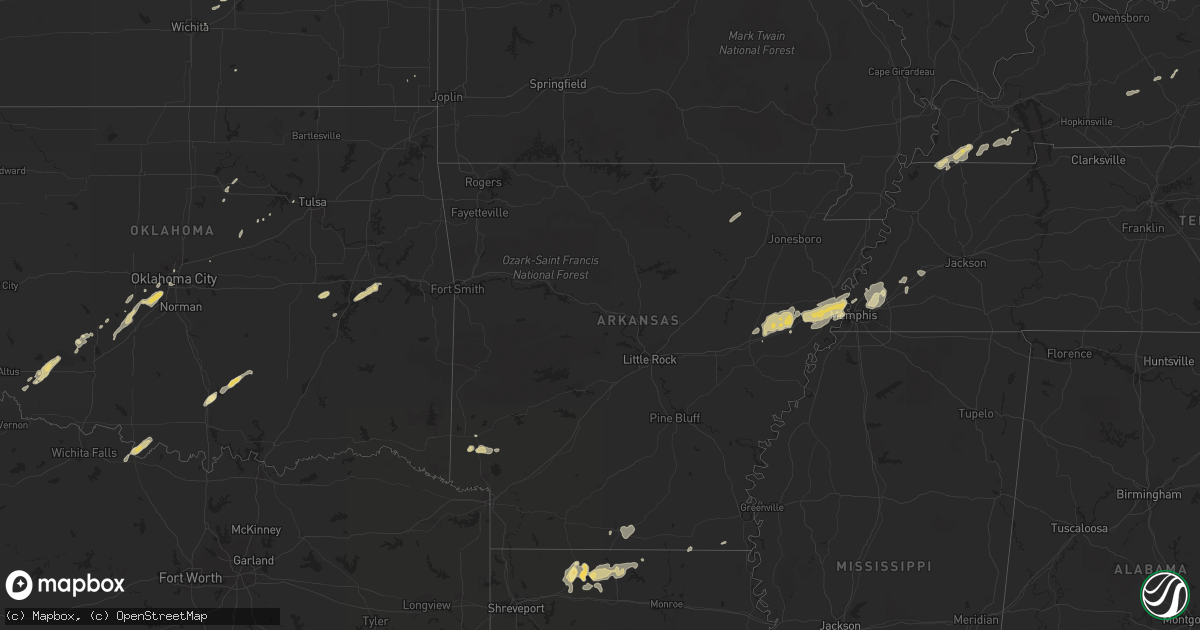
February 24 map
$229
one time, instant access
Download today. No call, no setup
Keep the $229
Bought the map and want the full workflow? Apply the entire $229 to a subscription within 7 days. None of it is wasted.
Every map, not just this one
This buys you this map. Subscription and you get every map we run, in the markets you choose from a few cities to whole states to nationwide. Plus real-time alerts the moment a storm fires.
Contact data
Name, contact info, occupancy, even credit band for addresses in the footprint. You go from where it hit to who to call.
Become the source they trust
Unlimited branding weather history reports on demand. You already have the documented answer ready for the property owner, and you are the one who showed up with it.
Property data and RoofTrace estimates
Pull up any address you have got, its value and the exact code rules for that jurisdiction, straight from One Click Code. Then RoofTrace estimates the squares, pitch, and roof value, priced the way you price.
Storm reports in Mississippi
Mississippi
| Date | Description |
|---|---|
| 02/23/201111:18 PM CST | A couple trees down...1 across cr 168. |
| 02/23/201111:04 PM CST | A couple trees were blown down. |
| 02/23/201110:17 PM CST | A couple trees were blown down. |
| 02/23/201110:15 PM CST | 8 trees were blown down around the city of caledonia. |
| 02/23/201110:15 PM CST | A tree was blown down on a house in the city of columbus. |
| 02/23/201110:03 PM CST | A couple trees were blown down. |
| 02/23/20119:57 PM CST | Several trees blown down. |
| 02/23/20119:55 PM CST | Trees and powerlines down on jasper street |
| 02/23/20119:53 PM CST | Trees and power lines down all over town. |
| 02/23/20119:52 PM CST | Trees...powerlines and power poles down |
| 02/23/20119:51 PM CST | Limbs and mailboxes blown over...car blown over near beaver lake. |
| 02/23/20119:50 PM CST | Utility lines along old fannin rd were damaged by large tree limbs. Time estimated. |
| 02/23/20119:50 PM CST | Lewisburg and match hatcher trees down |
| 02/23/20119:50 PM CST | Several trees down across belmont |
| 02/23/20119:44 PM CST | A few trees down and a fence blown down. |
| 02/23/20119:38 PM CST | Trees/power lines down in new wren...cason...smithville. 3 mobile homes with some damage. |
| 02/23/20119:35 PM CST | Trees down in northwestern and western leake county |
| 02/23/20119:32 PM CST | Roof peeled back on a business near the intersection of north port road and hwy 76. |
| 02/23/20119:32 PM CST | Several trees down in saltillo...possible tornado. |
| 02/23/20119:30 PM CST | Several trees were blown down. |
| 02/23/20119:30 PM CST | Trees were downed along highway 407...highway 790...and highway 9 across choctaw county. |
| 02/23/20119:25 PM CST | A couple trees were downed...partially blocking dewees rd. Time estimated. |
| 02/23/20119:25 PM CST | Trees...powerlines and power poles down |
| 02/23/20119:25 PM CST | A local report indicates 59 MPH wind near TUPELO |
| 02/23/20119:25 PM CST | Trees and power lines down countywide. |
| 02/23/20119:25 PM CST | Trees down along highway 341 and county road 102. |
| 02/23/20119:20 PM CST | A few trees were downed across attala county. |
| 02/23/20119:15 PM CST | Several large trees down...some on cars around new harmony and blue springs |
| 02/23/20119:10 PM CST | Trees were downed across webster county. One tree fell across highway 9 near walthall...and a car accident resulted. Numerous power outages countywide. |
| 02/23/20119:00 PM CST | Trees and power lines were downed across all of montgomery county |
| 02/23/20118:50 PM CST | Trees were reported down in the city of lexington...including one tree blocking highway 17 n |
| 02/23/20118:40 PM CST | Several trees and power lines downed across yazoo county. Some trees were blocking roadways. Some minor tree fires were reported as a result of damaged utility lines. S |
| 02/23/20118:35 PM CST | Numerous trees down around carrollton...some trees blocking roads |
| 02/23/20118:30 PM CST | Several trees down in multiple locations |
| 02/23/20118:30 PM CST | Recorded at grenada municipal airport |
| 02/23/20118:20 PM CST | Trees were blown down in the northern part of the county. A large tree was downed across a road in money. |
| 02/23/20118:20 PM CST | A large fence was blown down at an industrial park near greenwood |
| 02/23/20118:16 PM CST | Trees down |
| 02/23/20118:15 PM CST | Two trees were downed between greenwood and itta bena |
| 02/23/20118:15 PM CST | Two homes were damaged in itta bena...one sustained roof damage...and the other sustained window damage. |
| 02/23/20118:15 PM CST | Trees and power lines were downed along pluck rd |
| 02/23/20118:15 PM CST | Power outage reported in greenwood. Likely from damaging winds. |
| 02/23/20118:00 PM CST | Trees were downed around nitta yuma |
| 02/23/20117:51 PM CST | Limbs and mailboxes blown over...car blown over near beaver lake. |
| 02/23/20117:50 PM CST | Tree limbs down and tin roofs off some structures |
| 02/23/20117:50 PM CST | Trees and power poles down. |
| 02/23/20117:50 PM CST | Trees and power lines knocked down |
| 02/23/20117:50 PM CST | Tornado tracked from grace 6.5 miles to 1.5 se nitta yuma in sharkey co. Estimated max winds 115 mph...path length 6.5...max path width 400 yds. Several homes sustained |
| 02/23/20117:44 PM CST | Estimated wind gust associated with the dozen downed power poles. |
| 02/23/20117:40 PM CST | Around a dozen power poles were downed by high winds. Several power outages in the area around the state penitentiary. |
| 02/23/20117:38 PM CST | Carport blown off of a mobile home and onto two nearby parked cars |
| 02/23/20117:30 PM CST | Estimated wind gust associated with the roof dmg to the casino outside greenville. |
| 02/23/20117:30 PM CST | Trees downed...some blocking roads...and roofs damaged in the city of cleveland |
| 02/23/20117:27 PM CST | Part of the roof blown off a casino near the mississippi river bridges. Several light poles also blown down in the parking lot. |
All States Impacted by Hail Map on February 24, 2011
Cities Impacted by Hail Map on February 24, 2011
- Carnegie, OK
- Springer, OK
- Davis, OK
- Somerville, TN
- Mason, TN
- Terral, OK
- Ryan, OK
- Columbus, KS
- Garnett, KS
- Homer, LA
- Apache, OK
- Forrest City, AR
- Colt, AR
- Proctor, AR
- Memphis, TN
- Turrell, AR
- Widener, AR
- Edmondson, AR
- Marion, AR
- Heth, AR
- Earle, AR
- West Memphis, AR
- Crawfordsville, AR
- Parkin, AR
- Sulphur, OK
- Goodwin, AR
- Palestine, AR
- Wynne, AR
- Lockesburg, AR
- Mineral Springs, AR
- Tipton, OK
- Frederick, OK
- Mcalester, OK
- Indianola, OK
- Dougherty, OK
- Checotah, OK
- Eufaula, OK
- Mountain Park, OK
- Snyder, OK
- Roosevelt, OK
- Union City, TN
- Hickman, KY
- Fulton, KY
- Haynesville, LA
- Horatio, AR
- Anadarko, OK
- Grady, AR
- Star City, AR
- Oklahoma City, OK
- Lisbon, LA
- Dubach, LA
- Morgantown, KY
- Mill Creek, OK
- Roff, OK
- Arlington, TN
- Atoka, TN
- Millington, TN
- Brighton, TN
- Chickasha, OK
- Pocasset, OK
- Verden, OK
- Union City, OK
- Mustang, OK
- Arcadia, LA
- Athens, LA
- Potwin, KS
- El Dorado, KS
- Benton, KS
- Towanda, KS
- Belton, KY
- Dunmor, KY
- Nashville, AR
- Mayfield, KY
- Sedalia, KY
- Wingo, KY
- Minden, LA
- Scammon, KS
- Hardin, KY
- Benton, KY
- Parkdale, AR
- Wilmot, AR
- Ringgold, TX
- Burns, KS
- Burden, KS
- Porum, OK
- Stigler, OK
- Clinton, KY
- Water Valley, KY
- South Fulton, TN
- Amber, OK
- Minco, OK
- Brownsville, TN
- Stanton, TN
- Blanchard, OK
- Cement, OK
- Newcastle, OK
- Tuttle, OK
- Pawnee, OK
- Glencoe, OK
- Stuart, OK
- Drumright, OK
- Frankston, TX
- Spearsville, LA
- Farmerville, LA
- Bernice, LA
- Stillwater, OK
- Fitzhugh, OK
- Wichita, KS
- Mannford, OK
- Munford, TN
- Drummonds, TN
- Jetson, KY
- Strawberry, AR
- Smithville, AR
- Cave City, AR
- Lawton, OK
- El Dorado, AR
- Sand Springs, OK
- Kincaid, KS
- Marion, LA
- Wheatley, AR
- Brinkley, AR
- Cushing, OK
- Anguilla, MS
- Silver City, MS
- Louise, MS
- Hamburg, AR
- Bastrop, LA
- Moro, AR
- Luther, OK
- Kirksey, KY
- Almo, KY
- Farmington, KY
- Murray, KY


