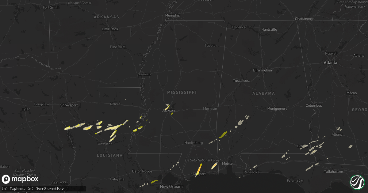
Hail Map in Mississippi on February 23, 2016
Get this storm
February 23 map
$229
one time, instant access
Download today. No call, no setup
Keep the $229
Bought the map and want the full workflow? Apply the entire $229 to a subscription within 7 days. None of it is wasted.
Every map, not just this one
This buys you this map. Subscription and you get every map we run, in the markets you choose from a few cities to whole states to nationwide. Plus real-time alerts the moment a storm fires.
Contact data
Name, contact info, occupancy, even credit band for addresses in the footprint. You go from where it hit to who to call.
Become the source they trust
Unlimited branding weather history reports on demand. You already have the documented answer ready for the property owner, and you are the one who showed up with it.
Property data and RoofTrace estimates
Pull up any address you have got, its value and the exact code rules for that jurisdiction, straight from One Click Code. Then RoofTrace estimates the squares, pitch, and roof value, priced the way you price.
Storm reports in Mississippi
Mississippi
| Date | Description |
|---|---|
| 02/23/20165:48 PM CST | Trees down on stateline battles rd. Near greene county. Residents unable to get out of driveway. |
| 02/23/20165:47 PM CST | Trees and debris at 6 henderson james rd. Near greene county line. |
| 02/23/20165:45 PM CST | A tornado touchdown occurred in a heavily wooded area near the green/wayne county line. Ef-1 damage was observed as numerous large diameter...greater than 2 feet...hard |
| 02/23/20165:45 PM CST | A local report indicates 1.75 inch wind near WADE |
| 02/23/20165:45 PM CST | Tree down along hwy 17 |
| 02/23/20165:40 PM CST | Tornado damage...trees down between avera and knobtown ms. |
| 02/23/20165:39 PM CST | Several pine trees uprooted and snapped...laying in the same direction. |
| 02/23/20165:38 PM CST | Several pine trees uprooted or snapped...laying in the same direction. |
| 02/23/20165:36 PM CST | Several pine trees uprooted or snapped laying in the same direction. A 40 x 52 storage building was destroyed with damage to siding of a mobile home. |
| 02/23/20165:35 PM CST | Downburst winds on the leading edge of a bow echo. Large pine trees uprooted or snapped...with trees laying in the same direction. |
| 02/23/20165:32 PM CST | A brief tornado touchdown occurred in the vicinity of shady hollow road. A couple of trees with large branches were sheared in a forested area several dozen yards to th |
| 02/23/20165:26 PM CST | Two trees down on pleasant grove sandersville rd. Near jack clark rd. |
| 02/23/20165:25 PM CST | Barn destroyed about 1 mile s. Of neely-avera rd. And 1/4 mile e. Of hwy 63. |
| 02/23/20165:25 PM CST | A tornado touched down along ms-63 southeast of the community of avera. A homestead was affected with metal roofing material from a barn lofted into an adjacent tree. A |
| 02/23/20165:21 PM CST | A severe thunderstorm blew farm equipment around...an aluminum boat into a pond...and a gate off a fence. In addition...tops were blown off several large oak trees. |
| 02/23/20165:15 PM CST | A tree was down on mcfarland road. |
| 02/23/20165:11 PM CST | Tree down on brown drive in the powers community. |
| 02/23/20165:08 PM CST | Minor roof damage to a home on gaines brewer road. A small greenhouse was also damaged. Time estimated from radar. |
| 02/23/20164:46 PM CST | Trees down on corinth road...elizabeth avenue...and north main street. Powerlines down on elizabeth avenue. |
| 02/23/20164:46 PM CST | Brief ef-0 rated tornado with max winds of 80 mph in southwest simpson county...snapped and uprooted softwood trees |
| 02/23/20164:42 PM CST | Ef-0 rated tornado with maximum winds of 85 mph and a path length of 1.2 miles and width of 100 yds...trees snapped and uprooted in a concentric pattern...a sign and fe |
| 02/23/20164:40 PM CST | Trees down in benton. |
| 02/23/20164:32 PM CST | Tornado began near entrekin road and ended near highway 13 snapping a few trees and a power pole along the way. Max winds of 75 mph. Path length of 3.9 miles and max wi |
| 02/23/20164:29 PM CST | Ef-1 tornado with maximum winds of 90 mph and a path length of 1.4 miles and width of 75 yards. Numerous trees were snapped along with some roof and fence damage. |
| 02/23/20164:22 PM CST | Reports of damage around purvis oloh road and mcraney road. Trees and powerlines down. Tornado debris signature observed in dual-pol radar data. |
| 02/23/20164:17 PM CST | *** 1 fatal *** ef-2 rated damage with path width of 115 yds has been found by the nws storm survey team...double wide mobile home was destroyed on sones road west of p |
| 02/23/20164:15 PM CST | *** 1 fatal *** ef-2 rated damage with max wind 115 mph has been found by the nws storm survey team...double wide mobile home was destroyed on sones road west of purvis |
| 02/23/20164:10 PM CST | Quarter to golfball sized hail reported in lyman. |
| 02/23/20164:07 PM CST | This brief tornado touchdown snapped and uprooted several trees just south of clear creek road in southwest lamar county. |
| 02/23/20164:00 PM CST | A local report indicates 1.00 inch wind near GULFPORT |
| 02/23/20163:57 PM CST | Preliminary damage to trees and structures consistent with low end ef-1. More details will be provided upon completion of survey. |
| 02/23/20163:57 PM CST | Emergency manager reported multiple structures with damage near henlefield |
| 02/23/20163:55 PM CST | Pea to quarter sized hail fell for a short duration |
| 02/23/20163:54 PM CST | This tornado started in pearl river county and crossed into southwest marion county where it snapped numerous softwood and hardwood trees. The tornado also caused roof |
| 02/23/20163:49 PM CST | Information from damage survey indicates an ef1 tornado with estimated wind speed of 105 mph began near donley burks road west of highway 43 and tracked northeast endin |
| 02/23/20163:45 PM CST | Ef-1 tornado with maximum winds of 90 mph and a path length of 0.5 miles and max width of 75 yards. Multiple trees were uprooted and a few structures heavily damaged. |
| 02/22/201610:50 PM CST | Large tree along stone blvd split in half on mississippi state campus. Also large limbs down on greensboro street in starkville. Both reports and pictures relayed via s |
| 02/22/201610:21 PM CST | A shed was damaged at a lumber business off ms hwy 12 |
| 02/22/201610:07 PM CST | Power lines downed across ms hwy 19 between zama and four corners |
| 02/22/20169:57 PM CST | Reported along ms hwy 468 |
| 02/22/20169:55 PM CST | Few trees down near hwy 49 around dabbs creek. |
| 02/22/20169:50 PM CST | Trees downed in the singleton area |
| 02/22/20169:48 PM CST | Trees downed in kosciusko and along ms hwy 35 south of kosciusko |
| 02/22/20169:45 PM CST | Tree across hwy 469 |
| 02/22/20169:40 PM CST | Shingles were blown off the roof of a home |
| 02/22/20169:25 PM CST | Tree down on a house on twin harbor place |
| 02/22/20169:18 PM CST | A few windshields were cracked along hwy 49 |
| 02/22/20168:45 PM CST | A tree was down on poplar hill road. |
| 02/22/20168:45 PM CST | A local report indicates 1.00 inch wind near 7 NNE PORT GIBSON |
| 02/22/20168:45 PM CST | Two trees were down on geoghegan road. |
| 02/22/20168:40 PM CST | Tree downed onto utility equipment along ms 547 |
| 02/22/20168:39 PM CST | Tree and power line down on grange hall rd |
| 02/22/20166:01 PM CST | A chicken pen was damaged. Trees were down on highway 13. Trees were also down on havard and entrekin roads. Possible tornado. |
All States Impacted by Hail Map on February 23, 2016
Cities Impacted by Hail Map on February 23, 2016
- Natchez, MS
- Olla, LA
- Jena, LA
- Trout, LA
- Grove Hill, AL
- Thomasville, AL
- Deville, LA
- Pineville, LA
- Norman Park, GA
- Moultrie, GA
- Altha, FL
- Clarksville, FL
- Grand Ridge, FL
- Marianna, FL
- Hermanville, MS
- Morgan, GA
- Sneads, FL
- Chattahoochee, FL
- Natchitoches, LA
- Westville, FL
- Samson, AL
- Geneva, AL
- Milton, FL
- Bagdad, FL
- Long Beach, MS
- Gulfport, MS
- Pass Christian, MS
- Saucier, MS
- Biloxi, MS
- Belle Rose, LA
- Donaldsonville, LA
- Jackson, MS
- Clinton, MS
- Converse, LA
- Leesburg, GA
- Gilbert, LA
- Fort Necessity, LA
- Wisner, LA
- Moss Point, MS
- Nathalie, VA
- Ridgeland, MS
- Climax, GA
- Bainbridge, GA
- Dothan, AL
- Pine Hill, AL
- Lower Peach Tree, AL
- Orange Beach, AL
- Richton, MS
- Oak Ridge, LA
- Colfax, LA
- Atlanta, LA
- Montgomery, LA
- Dry Prong, LA
- Arlington, GA
- Winnfield, LA
- Malone, FL
- Gordon, AL
- Jakin, GA
- Donalsonville, GA
- Bascom, FL
- Shelbyville, TX
- Coushatta, LA
- Robeline, LA
- Pleasant Hill, LA
- Marthaville, LA
- Pelican, LA
- Covington, LA
- Wilmer, AL
- Georgetown, LA
- Blakely, GA
- Jackson, AL
- Campti, LA
- State Line, MS
- Tullos, LA
- Bogalusa, LA
- Pollock, LA
- Lorman, MS
- Fayette, MS
- Bush, LA
- Vancleave, MS
- Ferriday, LA
- Damascus, GA
- Colquitt, GA
- Newellton, LA
- Defuniak Springs, FL
- Harrisonburg, LA
- Lucedale, MS
- Oakfield, GA
- Camden, AL
- Ponce De Leon, FL
- Columbia, AL
- Napoleonville, LA
- Pierre Part, LA
- Saint James, LA
- Clayton, LA
- Ashford, AL
- Webb, AL
- Madison, MS
- Flora, MS
- Saint Joseph, LA
- Citronelle, AL
- Cowarts, AL
- Pensacola, FL
- Bonifay, FL
- Pansey, AL
- Chatom, AL
- Fruitdale, AL
- Catherine, AL
- Millry, AL
- Port Gibson, MS
- Pearl, MS
- Florence, MS
- Brandon, MS
- Garyville, LA
- Gramercy, LA
- Paulina, LA
- Cloutierville, LA
- Aimwell, LA
- Enterprise, LA
- Frankville, AL


