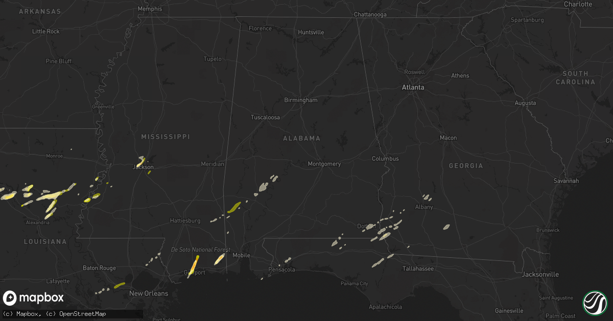
Hail Map in Alabama on February 23, 2016
Get this storm
February 23 map
$229
one time, instant access
Download today. No call, no setup
Keep the $229
Bought the map and want the full workflow? Apply the entire $229 to a subscription within 7 days. None of it is wasted.
Every map, not just this one
This buys you this map. Subscription and you get every map we run, in the markets you choose from a few cities to whole states to nationwide. Plus real-time alerts the moment a storm fires.
Contact data
Name, contact info, occupancy, even credit band for addresses in the footprint. You go from where it hit to who to call.
Become the source they trust
Unlimited branding weather history reports on demand. You already have the documented answer ready for the property owner, and you are the one who showed up with it.
Property data and RoofTrace estimates
Pull up any address you have got, its value and the exact code rules for that jurisdiction, straight from One Click Code. Then RoofTrace estimates the squares, pitch, and roof value, priced the way you price.
Storm reports in Alabama
Alabama
| Date | Description |
|---|---|
| 02/23/20165:53 PM CST | A shed and storage building was heavily damaged 3/4 miles north of highway 56 and 1 mile east of the al/ms line. |
| 02/23/20164:36 PM CST | Shingles off roof of homes. Windows broken. Car windows broken. Trash cans and patio furniture blown around. Possible tornado. Updated information. |
| 02/23/20164:22 PM CST | One home with minor roof damage. One shed with a section of its roof removed. Numerous trees uprooted and snapped. A 4.8 mile long path on a just west of due north orie |
| 02/23/20164:20 PM CST | Possible roof damage. Radar tds signature at 425 pm cdt. Time estimated by radar. |
| 02/23/20163:59 PM CST | Shingles off roof of homes. Windows broken. Car windows broken. Trash cans and patio furniture blown around. Updated information. Time estimated by radar. Updated to fi |
| 02/23/20164:14 AM CST | Tree fell onto home and damaged portion of roof. Tree fell and damaged portion of barn. Power lines down. Oak tree about 13 inches in diameter snapped. 4 pine trees dow |
| 02/23/20164:04 AM CST | A brief weak tornado touched down along cr 97 and moved east-northeast through a largely rural and wooded area. It lifted along peaceful valley rd. The majority of the |
| 02/23/20161:45 AM CST | Multiple trees down along highway 31 near the cullman and morgan county line. |
| 02/22/201611:20 PM CST | Trees blown down near a residence in columbia. Public post to wtvy facebook. |
| 02/22/201611:02 PM CST | A short tornado path was observed along cr-65 just to the east of its intersection with highway 95. Many large trees were snapped or uprooted along this short path. |
| 02/22/201610:54 PM CST | A short tornado track was determined along cr-53 just north of its intersection with cr-26. This was a concentrated area of tree damage. |
| 02/22/201610:49 PM CST | Damage to 5 residences and numerous trees and power lines down northeast of headland. Debris signature on radar at the time. |
| 02/22/201610:38 PM CST | Updated kinsey report...additional media reports of damage in the kinsey area with numerous trees and power lines down and carports destroyed. There was a debris signat |
| 02/22/201610:38 PM CST | This tornado was the fifth tornado to be spawned by the same thunderstorm. The tornado initially developed near cr-83 and the city limits of headland where large trees |
| 02/22/201610:35 PM CST | Large pine tree down at hazelwood and kent in dothan. |
| 02/22/201610:34 PM CST | Rated ef1 with a path length of 3.8 miles. This was the fourth tornado to develop in northwest houston county. The tornado began just south of westgate parkway and then |
| 02/22/201610:33 PM CST | Numerous reports of damage on the northwest side of dothan including many trees damaged and structural damage as well. In the vicinity of the walmart. There was a debri |
| 02/22/201610:32 PM CST | 8 power poles snapped on technology drive and trees also brought down power lines at westgate parkway and provincial street. |
| 02/22/201610:32 PM CST | Wtvy reports damage to northside walmart with possible roof damage and damage to doors. Also reports of power lines snapped in half and trees down in the area. |
| 02/22/201610:31 PM CST | Rated ef1 with a path length of 1.9 miles. Damage was focused at the athletic center of a private school and a nearby neighborhood. Concrete block baseball dugout was d |
| 02/22/201610:28 PM CST | Powerlines down on murphy mill road. Also power lines down on westgate at technology. |
| 02/22/201610:28 PM CST | Tree blown into the roadway west main at john d odom. |
| 02/22/201610:24 PM CST | This tornado...rated ef1...initially developed in houston county...briefly crossed into dale county...before crossing back into houston county and causing damage in the |
| 02/22/201610:20 PM CST | Trees blown down across county highway 105. |
| 02/22/201610:15 PM CST | This was a weak tornado just north of the houston-geneva county border. It removed metal roofing from several barns and porches. Multiple trees were blown down. Path le |
| 02/22/201610:05 PM CST | Roof damage reported in hartford |
| 02/22/20169:55 PM CST | Numerous trees reported down in geneva county across various parts of the county. Also many power outages reported by wiregrass electric coop. |
| 02/22/20169:40 PM CST | Trees down across county highway 65. |
| 02/22/20169:39 PM CST | Trees blown down across johnny johnson rd in the general vicinity of open pond road. |
| 02/22/20169:12 PM CST | Tree down hwy 154 at mile marker 6... Across road. |
| 02/22/20166:58 PM CST | Trees down on sumter county road 9. One large tree across county road 9 north of the intersection of county road 10. |
| 02/22/20166:47 PM CST | Trees down on sumter county road 9. One large tree across county road 9 north of the intersection of county road 10. Corrected - time estimated by radar. |
| 02/22/20166:30 PM CST | Tree down hwy 154 at mile marker 6... Across road. |
| 02/22/20166:30 PM CST | Tree down on residence at 155 maple dr. |
| 02/22/20166:30 PM CST | Large tree down across hwy. 69 1 mile s. Of coffeeville. |
| 02/22/20166:20 PM CST | Tree on residence at 155 maple dr. |
| 02/22/20166:03 PM CST | Dual-pol tornado debris signature detected from kgwx nexrad. |
| 02/22/20166:03 PM CST | Damage to the roof of a home. Trees and power lines down. Dual-pol tornado debris signature detected from kgwx nexrad. Updated location and information. |
| 02/22/20166:01 PM CST | One home with minor roof damage...and one garage had a part of its tin peeled back. Numerous trees uprooted. 2.2 mile long path on a north-northwest orientation. |
All States Impacted by Hail Map on February 23, 2016
Cities Impacted by Hail Map on February 23, 2016
- Natchez, MS
- Olla, LA
- Jena, LA
- Trout, LA
- Grove Hill, AL
- Thomasville, AL
- Deville, LA
- Pineville, LA
- Norman Park, GA
- Moultrie, GA
- Altha, FL
- Clarksville, FL
- Grand Ridge, FL
- Marianna, FL
- Hermanville, MS
- Morgan, GA
- Sneads, FL
- Chattahoochee, FL
- Natchitoches, LA
- Westville, FL
- Samson, AL
- Geneva, AL
- Milton, FL
- Bagdad, FL
- Long Beach, MS
- Gulfport, MS
- Pass Christian, MS
- Saucier, MS
- Biloxi, MS
- Belle Rose, LA
- Donaldsonville, LA
- Jackson, MS
- Clinton, MS
- Converse, LA
- Leesburg, GA
- Gilbert, LA
- Fort Necessity, LA
- Wisner, LA
- Moss Point, MS
- Nathalie, VA
- Ridgeland, MS
- Climax, GA
- Bainbridge, GA
- Dothan, AL
- Pine Hill, AL
- Lower Peach Tree, AL
- Orange Beach, AL
- Richton, MS
- Oak Ridge, LA
- Colfax, LA
- Atlanta, LA
- Montgomery, LA
- Dry Prong, LA
- Arlington, GA
- Winnfield, LA
- Malone, FL
- Gordon, AL
- Jakin, GA
- Donalsonville, GA
- Bascom, FL
- Shelbyville, TX
- Coushatta, LA
- Robeline, LA
- Pleasant Hill, LA
- Marthaville, LA
- Pelican, LA
- Covington, LA
- Wilmer, AL
- Georgetown, LA
- Blakely, GA
- Jackson, AL
- Campti, LA
- State Line, MS
- Tullos, LA
- Bogalusa, LA
- Pollock, LA
- Lorman, MS
- Fayette, MS
- Bush, LA
- Vancleave, MS
- Ferriday, LA
- Damascus, GA
- Colquitt, GA
- Newellton, LA
- Defuniak Springs, FL
- Harrisonburg, LA
- Lucedale, MS
- Oakfield, GA
- Camden, AL
- Ponce De Leon, FL
- Columbia, AL
- Napoleonville, LA
- Pierre Part, LA
- Saint James, LA
- Clayton, LA
- Ashford, AL
- Webb, AL
- Madison, MS
- Flora, MS
- Saint Joseph, LA
- Citronelle, AL
- Cowarts, AL
- Pensacola, FL
- Bonifay, FL
- Pansey, AL
- Chatom, AL
- Fruitdale, AL
- Catherine, AL
- Millry, AL
- Port Gibson, MS
- Pearl, MS
- Florence, MS
- Brandon, MS
- Garyville, LA
- Gramercy, LA
- Paulina, LA
- Cloutierville, LA
- Aimwell, LA
- Enterprise, LA
- Frankville, AL


