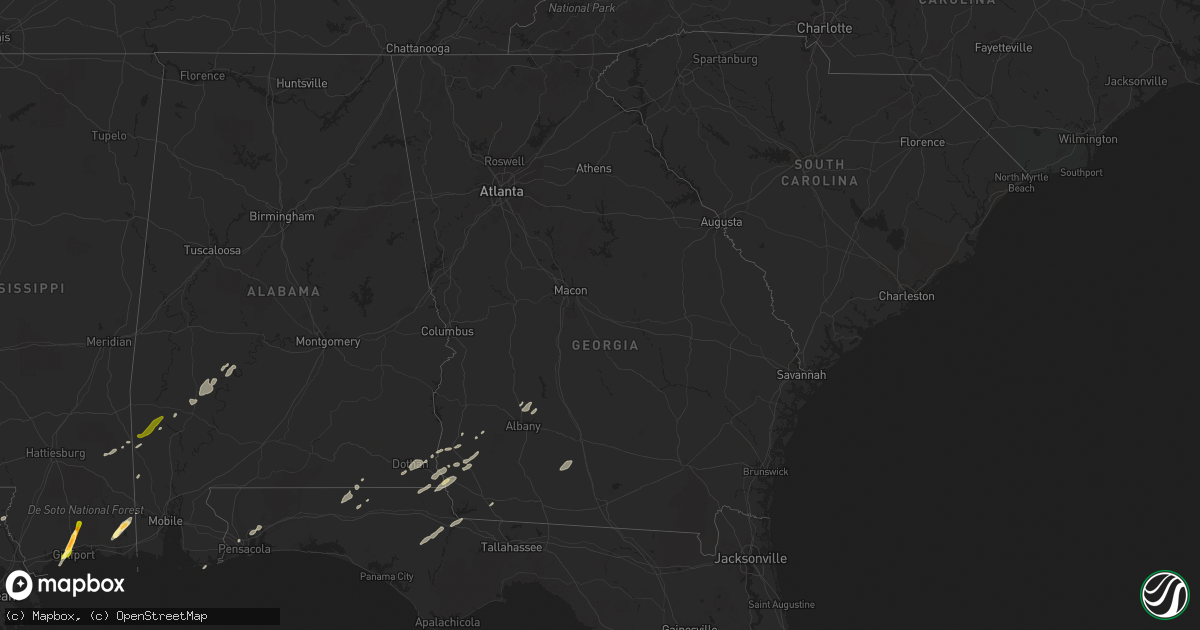
Hail Map in Georgia on February 23, 2016
Get this storm
February 23 map
$229
one time, instant access
Download today. No call, no setup
Keep the $229
Bought the map and want the full workflow? Apply the entire $229 to a subscription within 7 days. None of it is wasted.
Every map, not just this one
This buys you this map. Subscription and you get every map we run, in the markets you choose from a few cities to whole states to nationwide. Plus real-time alerts the moment a storm fires.
Contact data
Name, contact info, occupancy, even credit band for addresses in the footprint. You go from where it hit to who to call.
Become the source they trust
Unlimited branding weather history reports on demand. You already have the documented answer ready for the property owner, and you are the one who showed up with it.
Property data and RoofTrace estimates
Pull up any address you have got, its value and the exact code rules for that jurisdiction, straight from One Click Code. Then RoofTrace estimates the squares, pitch, and roof value, priced the way you price.
Storm reports in Georgia
Georgia
| Date | Description |
|---|---|
| 02/23/20165:20 AM CST | Tree down on golf course road. Time estimated by radar. |
| 02/23/20164:40 AM CST | Georgia power reported power lines down on belair road in the augusta area. Public report of estimated winds around 60 mph. |
| 02/23/20163:55 AM CST | Gas station awning damaged off i-75 exit 22. |
| 02/23/20163:55 AM CST | Trees down along val del road. |
| 02/23/20163:55 AM CST | Tree down on west adair street |
| 02/23/20163:02 AM CST | Tree down near intersection of 3rd street and 12th ave |
| 02/23/20162:39 AM CST | Tree on powerline. |
| 02/23/20162:26 AM CST | Powerline down. |
| 02/23/20162:26 AM CST | 3 to 4 trees down throughout thomasville. |
| 02/23/20162:10 AM CST | Roof partially blown off lighthouse church near sylvester. Reported by wfxl-tv. |
| 02/23/20161:49 AM CST | Trees down along providence road. Tds signature noted on radar. |
| 02/23/20161:47 AM CST | Several pecan trees were blown down in a field along highway 27 about 11 miles south of bainbridge |
| 02/23/20161:45 AM CST | Rated ef1 with estimated max winds of 90 mph. 12.9 mile track with max width of 400 yards. The tornado touched down southwest of whigham and travelled northeast... Cros |
| 02/23/20161:26 AM CST | There was minor roof damage to a structure near the palmer hotel |
| 02/23/20161:06 AM CST | Tree down on spring creek road. |
| 02/23/201612:40 AM CST | Metal roof blown off a pole barn on highway 33 between cofer and landfill roads. |
| 02/23/201612:33 AM CST | Tree uprooted just west of elmodel with other large limbs blown down in the area |
| 02/23/201612:30 AM CST | A few trees blown down in northern worth county. |
| 02/23/201612:26 AM CST | Tornado touched down briefly along gray moss rd with a path length of less than 0.5 mi. Rated ef1. There was significant damage to a mobile home roof...along with the c |
| 02/23/201612:26 AM CST | Roof off of brick house and mobile home severely damaged and debris in trees on gray moss rd. No injuries. |
| 02/23/201612:22 AM CST | Large pine tree blown down in northwest albany per public post to walb-tv facebook page. |
| 02/23/201612:22 AM CST | Tree blown down off stocks dairy road per a public post to walb-tv facebook page. |
| 02/23/201612:22 AM CST | Two trees were reported to have fallen on a home on the 2800 block of doublegate drive |
| 02/23/201612:20 AM CST | Tree down on the 5400 block of old dawson road |
| 02/23/201612:15 AM CST | A few trees were blown down along highway 216 just into baker county. |
| 02/23/201612:10 AM CST | Tree blown down on hickory ridge court. |
| 02/23/201612:05 AM CST | A few trees were blown down just into early county along highway 27. |
| 02/23/201612:00 AM CST | Broadcast media reports multiple trees down along bobby locke road just off sasser herod road. Walb-tv report. |
| 02/22/201611:55 PM CST | Rated ef1 with a path length of 5.1 miles. Damage was primarily to pine and pecan trees. A portion of the southern end was a focused area of uprooted and snapped mature |
| 02/22/201611:50 PM CST | Tree down on power line near arlington resulting in power outage |
| 02/22/201611:15 PM CST | Trees downed around highway 37 near fort gaines. |
| 02/22/201611:07 PM CST | This tornado began around grimsley road with tree damage noted in surrounding fields. It then moved northeast... Crossing state highway 39 to the northwest of blakely. |
All States Impacted by Hail Map on February 23, 2016
Cities Impacted by Hail Map on February 23, 2016
- Natchez, MS
- Olla, LA
- Jena, LA
- Trout, LA
- Grove Hill, AL
- Thomasville, AL
- Deville, LA
- Pineville, LA
- Norman Park, GA
- Moultrie, GA
- Altha, FL
- Clarksville, FL
- Grand Ridge, FL
- Marianna, FL
- Hermanville, MS
- Morgan, GA
- Sneads, FL
- Chattahoochee, FL
- Natchitoches, LA
- Westville, FL
- Samson, AL
- Geneva, AL
- Milton, FL
- Bagdad, FL
- Long Beach, MS
- Gulfport, MS
- Pass Christian, MS
- Saucier, MS
- Biloxi, MS
- Belle Rose, LA
- Donaldsonville, LA
- Jackson, MS
- Clinton, MS
- Converse, LA
- Leesburg, GA
- Gilbert, LA
- Fort Necessity, LA
- Wisner, LA
- Moss Point, MS
- Nathalie, VA
- Ridgeland, MS
- Climax, GA
- Bainbridge, GA
- Dothan, AL
- Pine Hill, AL
- Lower Peach Tree, AL
- Orange Beach, AL
- Richton, MS
- Oak Ridge, LA
- Colfax, LA
- Atlanta, LA
- Montgomery, LA
- Dry Prong, LA
- Arlington, GA
- Winnfield, LA
- Malone, FL
- Gordon, AL
- Jakin, GA
- Donalsonville, GA
- Bascom, FL
- Shelbyville, TX
- Coushatta, LA
- Robeline, LA
- Pleasant Hill, LA
- Marthaville, LA
- Pelican, LA
- Covington, LA
- Wilmer, AL
- Georgetown, LA
- Blakely, GA
- Jackson, AL
- Campti, LA
- State Line, MS
- Tullos, LA
- Bogalusa, LA
- Pollock, LA
- Lorman, MS
- Fayette, MS
- Bush, LA
- Vancleave, MS
- Ferriday, LA
- Damascus, GA
- Colquitt, GA
- Newellton, LA
- Defuniak Springs, FL
- Harrisonburg, LA
- Lucedale, MS
- Oakfield, GA
- Camden, AL
- Ponce De Leon, FL
- Columbia, AL
- Napoleonville, LA
- Pierre Part, LA
- Saint James, LA
- Clayton, LA
- Ashford, AL
- Webb, AL
- Madison, MS
- Flora, MS
- Saint Joseph, LA
- Citronelle, AL
- Cowarts, AL
- Pensacola, FL
- Bonifay, FL
- Pansey, AL
- Chatom, AL
- Fruitdale, AL
- Catherine, AL
- Millry, AL
- Port Gibson, MS
- Pearl, MS
- Florence, MS
- Brandon, MS
- Garyville, LA
- Gramercy, LA
- Paulina, LA
- Cloutierville, LA
- Aimwell, LA
- Enterprise, LA
- Frankville, AL


