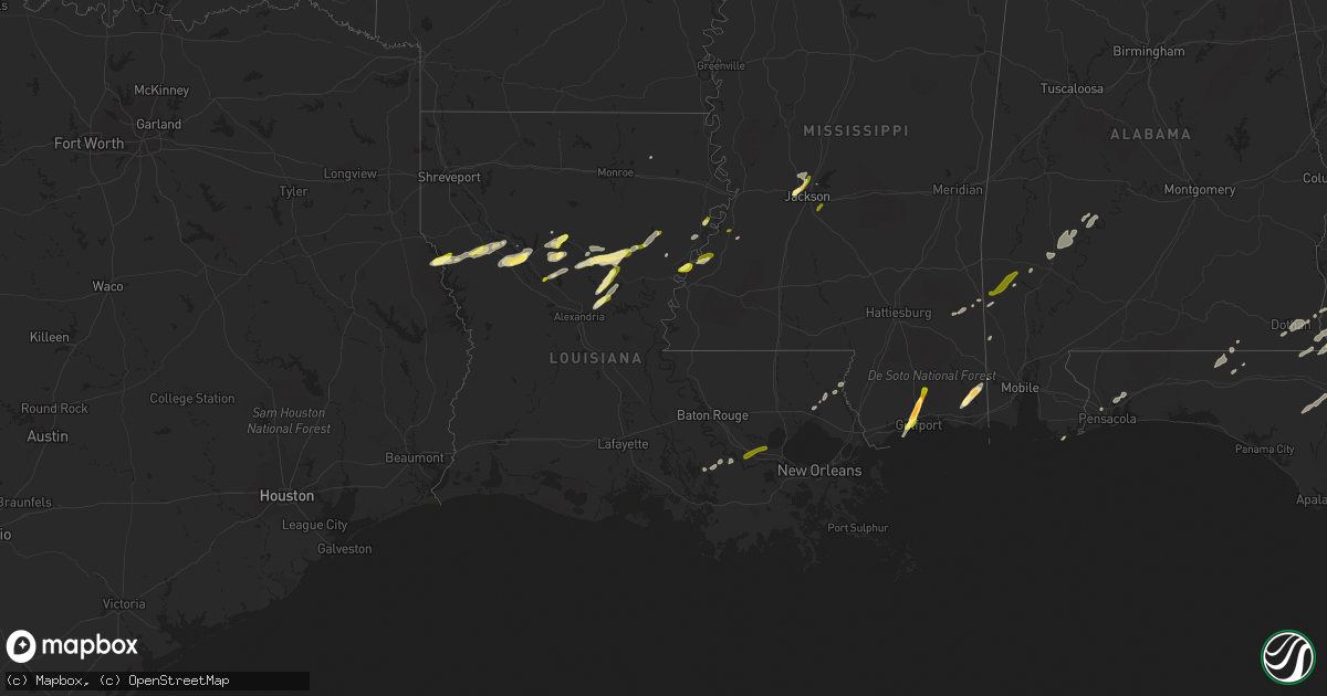
Hail Map in Louisiana on February 23, 2016
Get this storm
February 23 map
$229
one time, instant access
Download today. No call, no setup
Keep the $229
Bought the map and want the full workflow? Apply the entire $229 to a subscription within 7 days. None of it is wasted.
Every map, not just this one
This buys you this map. Subscription and you get every map we run, in the markets you choose from a few cities to whole states to nationwide. Plus real-time alerts the moment a storm fires.
Contact data
Name, contact info, occupancy, even credit band for addresses in the footprint. You go from where it hit to who to call.
Become the source they trust
Unlimited branding weather history reports on demand. You already have the documented answer ready for the property owner, and you are the one who showed up with it.
Property data and RoofTrace estimates
Pull up any address you have got, its value and the exact code rules for that jurisdiction, straight from One Click Code. Then RoofTrace estimates the squares, pitch, and roof value, priced the way you price.
Storm reports in Louisiana
Louisiana
| Date | Description |
|---|---|
| 02/23/20165:30 PM CST | Mostly trees snapped and minor shingle damage. 50-75 yards wide before dissipating. Also ef-0 in madisonville 50 yards wide. Damage to boat shed and some fascia off roo |
| 02/23/20165:30 PM CST | Trees downed on highway 190 near thompson road |
| 02/23/20165:30 PM CST | Trees downed on highway 190 near thompson street. |
| 02/23/20165:25 PM CST | A local report indicates 1.25 inch wind near NATCHITOCHES |
| 02/23/20165:23 PM CST | Hail lasted seven minutes and partially covered the ground. |
| 02/23/20165:07 PM CST | A local report indicates 1.00 inch wind near 3 SE PLEASANT HILL |
| 02/23/20165:02 PM CST | Draw bridge of causeway weather equipment measured a sustained wind speed of 60 mph with a gust of 120 mph. This was very close to the circulation of a storm with a his |
| 02/23/20164:40 PM CST | Madisonville mayor reported large metal canopy blown off at madisonville boat launch. One home near the boat launch was reported to have some damage. Event time estimat |
| 02/23/20164:35 PM CST | Widespread structural damage through laplace to homes and businesses. Numerous homes with major damage. Nws survey team will investigate. |
| 02/23/20164:35 PM CST | Preliminary estimate of 130 mph over 1/4 mile wide path. More details will be provided upon completion of survey. |
| 02/23/20164:15 PM CST | Nws storm survey found trees snapped and uprooted near mile marker 12 on interstate 55. Winds estimated at 100 mph rating the tornado an ef1. Width of 200 yards and a p |
| 02/23/20164:05 PM CST | Radar confirmed tornado. |
| 02/23/20163:38 PM CST | Emergency manager reported several powerlines downed in convent. |
| 02/23/20163:38 PM CST | *** 2 fatal *** updated information from damage survey indicates that an upper end ef2 tornado touched down about 3 mile west of plattenville and tracked northeast for |
| 02/23/20163:31 PM CST | *** 2 fatal *** the maximum wind and ef scale for assumption parish to st james parish strong tornado has been increased slightly to lower end ef3 tornado...versus prev |
| 02/23/20163:30 PM CST | Camp moved 6 inches... Minor roof damage to a few structures... Powerlines and pole down |
| 02/23/20163:23 PM CST | Tornado confirmed by radar tds. Emergency manager received multiple reports of tree and structure damage and is investigating. |
| 02/23/20163:20 PM CST | Possible tornado damage on highway 405 in white castle. Power poles downed and roof damage. |
| 02/23/20162:37 PM CST | Storm survey confirms ef1 tornado occurred between baldwin and franklin. The tornado touched down in a sugar cane field and traveled 2.6 miles before disipating in anot |
| 02/23/20162:36 PM CST | Report of multiple mobile homes damage and power lines down between baldwin and franklin. Time estimated from radar. |
| 02/23/20161:14 PM CST | Information from damage survey indicates an ef0 tornado with estimated wind speed of 85 mph began 3 and half miles east northeast of montpelier near green lane and trac |
| 02/23/20161:14 PM CST | Damage was mainly to an unsecured trailer and to some weak trees. More details will follow later upon conclusion of survey. |
| 02/23/20161:14 PM CST | Trailer received moderate damage and was rolled over. In addition multiple trees were damaged. |
| 02/23/20161:02 PM CST | Report of utility pole down on landry rd. Time estimated from radar. |
| 02/23/201612:45 PM CST | Preliminary estimated 120 mph with a 1/4 mile wide path. More details will be provided at the conclusion of the survey. |
| 02/23/201612:45 PM CST | Large delivery truck flipped on its side near highway 1036 near charles holden road. |
| 02/23/201612:17 PM CST | Tornado crossed hoo shoo too road east of south tiger bend road. |
| 02/23/201612:10 PM CST | Trained spotter reported tornado crossed i-10 near exit 171. |
| 02/23/201612:05 PM CST | Significant damage to golds gym in prairieville. |
| 02/23/201611:42 AM CST | Significant damage to golds gym in prairieville. |
| 02/23/201611:42 AM CST | Em said resident reports roof damage and power pole damage on richland rd. Possible tornado. 6 homes received minor damage. 3 utility poles and service lines down. |
| 02/23/201611:11 AM CST | Estimated 80 mph along a short path between highway 48 and airline highway in the vicinity of salvador road. More details will be sent at the conclusion of the survey. |
| 02/23/201610:56 AM CST | Report of bay doors and workshop damaged in boutte. Also report of vinyl siding lost on a home in ama along with another home in ama having their patio cover ripped off |
| 02/22/20167:52 PM CST | Quarter size hail reported at the 84 quick stop. |
| 02/22/20167:47 PM CST | Tree down across hwy 17 near the intersection of hwy 588. |
| 02/22/20167:35 PM CST | A local report indicates 1.00 inch wind near WISNER |
| 02/22/20167:15 PM CST | Dime to quarter size. |
| 02/22/20167:14 PM CST | Damage was mainly to an unsecured trailer and to some weak trees. More details will follow later upon conclusion of survey. |
| 02/22/20166:51 PM CST | Photo of quarter sized hail posted to twitter. |
| 02/22/20166:50 PM CST | Photo of hail from kalb-tv facebook page. |
| 02/22/20166:00 PM CST | Photo of hail from kalb-tv facebook page. |
All States Impacted by Hail Map on February 23, 2016
Cities Impacted by Hail Map on February 23, 2016
- Natchez, MS
- Olla, LA
- Jena, LA
- Trout, LA
- Grove Hill, AL
- Thomasville, AL
- Deville, LA
- Pineville, LA
- Norman Park, GA
- Moultrie, GA
- Altha, FL
- Clarksville, FL
- Grand Ridge, FL
- Marianna, FL
- Hermanville, MS
- Morgan, GA
- Sneads, FL
- Chattahoochee, FL
- Natchitoches, LA
- Westville, FL
- Samson, AL
- Geneva, AL
- Milton, FL
- Bagdad, FL
- Long Beach, MS
- Gulfport, MS
- Pass Christian, MS
- Saucier, MS
- Biloxi, MS
- Belle Rose, LA
- Donaldsonville, LA
- Jackson, MS
- Clinton, MS
- Converse, LA
- Leesburg, GA
- Gilbert, LA
- Fort Necessity, LA
- Wisner, LA
- Moss Point, MS
- Nathalie, VA
- Ridgeland, MS
- Climax, GA
- Bainbridge, GA
- Dothan, AL
- Pine Hill, AL
- Lower Peach Tree, AL
- Orange Beach, AL
- Richton, MS
- Oak Ridge, LA
- Colfax, LA
- Atlanta, LA
- Montgomery, LA
- Dry Prong, LA
- Arlington, GA
- Winnfield, LA
- Malone, FL
- Gordon, AL
- Jakin, GA
- Donalsonville, GA
- Bascom, FL
- Shelbyville, TX
- Coushatta, LA
- Robeline, LA
- Pleasant Hill, LA
- Marthaville, LA
- Pelican, LA
- Covington, LA
- Wilmer, AL
- Georgetown, LA
- Blakely, GA
- Jackson, AL
- Campti, LA
- State Line, MS
- Tullos, LA
- Bogalusa, LA
- Pollock, LA
- Lorman, MS
- Fayette, MS
- Bush, LA
- Vancleave, MS
- Ferriday, LA
- Damascus, GA
- Colquitt, GA
- Newellton, LA
- Defuniak Springs, FL
- Harrisonburg, LA
- Lucedale, MS
- Oakfield, GA
- Camden, AL
- Ponce De Leon, FL
- Columbia, AL
- Napoleonville, LA
- Pierre Part, LA
- Saint James, LA
- Clayton, LA
- Ashford, AL
- Webb, AL
- Madison, MS
- Flora, MS
- Saint Joseph, LA
- Citronelle, AL
- Cowarts, AL
- Pensacola, FL
- Bonifay, FL
- Pansey, AL
- Chatom, AL
- Fruitdale, AL
- Catherine, AL
- Millry, AL
- Port Gibson, MS
- Pearl, MS
- Florence, MS
- Brandon, MS
- Garyville, LA
- Gramercy, LA
- Paulina, LA
- Cloutierville, LA
- Aimwell, LA
- Enterprise, LA
- Frankville, AL


