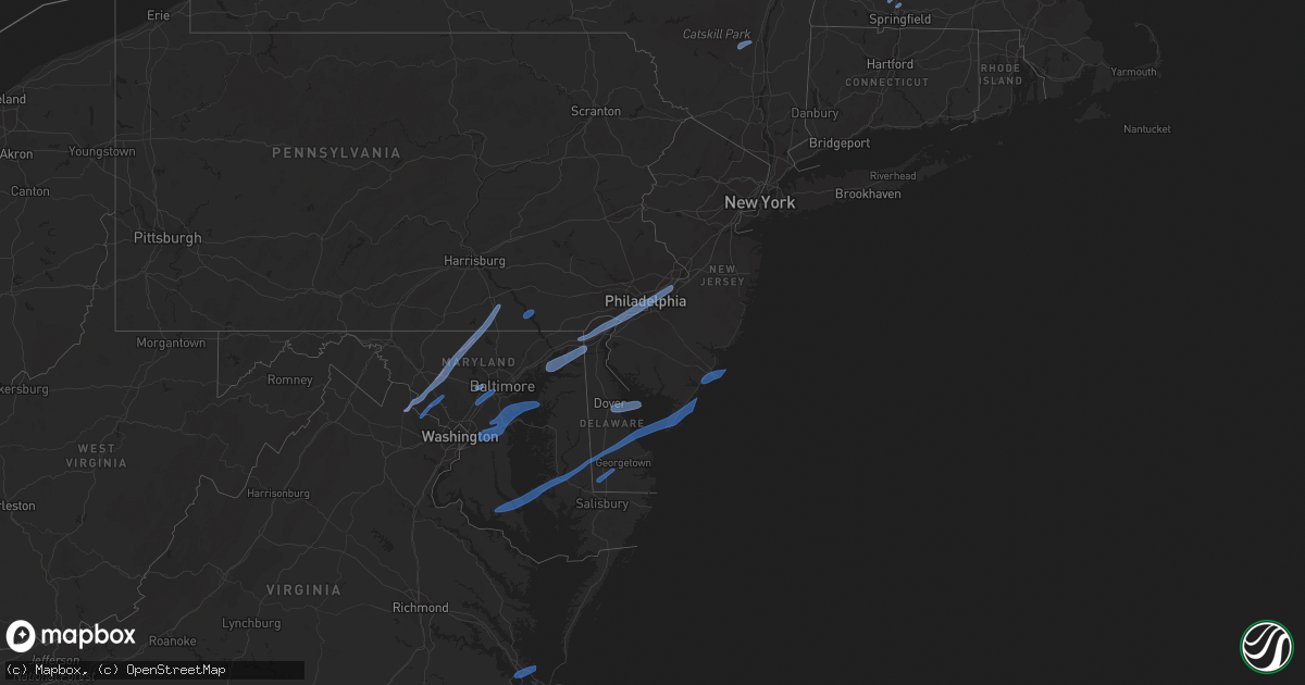
Hail Map in Maryland on February 7, 2020
Get this storm
February 7 map
$229
one time, instant access
Download today. No call, no setup
Keep the $229
Bought the map and want the full workflow? Apply the entire $229 to a subscription within 7 days. None of it is wasted.
Every map, not just this one
This buys you this map. Subscription and you get every map we run, in the markets you choose from a few cities to whole states to nationwide. Plus real-time alerts the moment a storm fires.
Contact data
Name, contact info, occupancy, even credit band for addresses in the footprint. You go from where it hit to who to call.
Become the source they trust
Unlimited branding weather history reports on demand. You already have the documented answer ready for the property owner, and you are the one who showed up with it.
Property data and RoofTrace estimates
Pull up any address you have got, its value and the exact code rules for that jurisdiction, straight from One Click Code. Then RoofTrace estimates the squares, pitch, and roof value, priced the way you price.
Storm reports in Maryland
Maryland
| Date | Description |
|---|---|
| 02/07/202010:35 AM CST | Tree branch onto power lines near ritchie highway and baltimore annapolis blvd |
| 02/07/20208:43 AM CST | Power pole knocked down. Time estimated from radar. Report via social media. |
| 02/07/20208:40 AM CST | Several reports of downed trees. Time estimated from radar. |
| 02/07/20208:39 AM CST | An ef-1 tornado briefly touched down near the elk mills quarry in cecil county... Maryland. The tornado uprooted and snapped numerous softwood trees just east and north |
| 02/07/20208:35 AM CST | A local report indicates 58 MPH wind near 8 E SMITH ISLAND |
| 02/07/20208:35 AM CST | Straight line winds collapsed a block barn on howard road north of federalsburg. A swath of damage to multiple other nearby structures consistent with winds of 70-80 mp |
| 02/07/20208:30 AM CST | Significant structural damage to a barn. Time estimated from radar. |
| 02/07/20208:30 AM CST | Downed utility on state highway 480 at sunset boulevard. Time estimated from radar. |
| 02/07/20208:27 AM CST | Large tree limb knocked down. Report via social media. |
| 02/07/20208:24 AM CST | Reports of downed trees in the area of rock hall road. Time estimated from radar. |
| 02/07/20208:23 AM CST | Wind blown debris in the road on i-95 north of exit 93. Time estimated from radar. |
| 02/07/20208:21 AM CST | Tree knocked down. Time estimated from radar. Report via social media. |
| 02/07/20208:18 AM CST | A local report indicates 64 MPH wind near 7 SSE SAINT GEORGE ISLA |
| 02/07/20208:17 AM CST | A local report indicates 67 MPH wind near PATUXENT RIVER NAS |
| 02/07/20208:16 AM CST | A local report indicates 62 MPH wind near PATUXENT RIVER NAS |
| 02/07/20208:12 AM CST | A marina structure collapsed impacting 20 boats |
| 02/07/20208:12 AM CST | Large tree splintered down the middle. |
| 02/07/20208:12 AM CST | A local report indicates 63 MPH wind near SOLOMONS |
| 02/07/20208:02 AM CST | 12 reports of trees down in the area around solomons and lusby. Approximately half of the reports involved trees falling onto homes. |
| 02/07/20208:02 AM CST | Tree down near intersection of shore acres rd and stonington dr. |
| 02/07/20208:02 AM CST | Tree down near intersection of eaglehill rd and n shore rd |
| 02/07/20208:00 AM CST | A local report indicates 65 MPH wind near 1 SSE SOTTERLEY |
| 02/07/20207:56 AM CST | Tree down onto rt 4 southbound lane near lower pindell rd |
| 02/07/20207:55 AM CST | Tree down blocking road near intersection of fishers station rd and w. Bayfront rd |
| 02/07/20207:52 AM CST | Tree branch down onto road at 188 mountain rd |
| 02/07/20207:51 AM CST | *** 1 inj *** roof removed from small building of business. One occupant injured. |
| 02/07/20207:51 AM CST | Tree down blocking roadway near intersection of governors bridge rd and davidsonville rd |
| 02/07/20207:50 AM CST | 29 reports of trees down across roadways and/or powerlines...mainly across central/northern parts of the county |
| 02/07/20207:42 AM CST | Large tree branch down onto power lines near intersection of largo rd and hancock dr |
| 02/07/20207:42 AM CST | Unoccupied barn destroyed |
| 02/07/20207:29 AM CST | Tree down near intersection of race rd and church ave |
| 02/07/20207:20 AM CST | Tree down at 8432 high ridge rd |
| 02/07/20207:20 AM CST | Tree down near intersection of vollmerhausen rd and dragonclaw |
| 02/07/20207:20 AM CST | Tree down near intersection of rogers ave and brightwell dr |
| 02/07/20207:19 AM CST | Tree down near intersection of gilford rd and oakland mills rd |
| 02/07/20207:19 AM CST | Tree down near intersection of oakland mills rd and dobbin rd |
| 02/07/20207:19 AM CST | Tree down near intersection of red branch rd and old annapolis rd |
| 02/07/20207:18 AM CST | Tree down to the south of the i-70 and us 29 ramp |
| 02/07/20207:17 AM CST | Tree down at 5870 thunder hill rd |
| 02/07/20207:15 AM CST | A local report indicates 67 MPH wind near MILLERS |
| 02/07/20207:15 AM CST | Tree down near intersection of cedar ln and lightfoot path |
| 02/07/20207:13 AM CST | Tree down near intersection of dobbin rd and mcgaw ct |
| 02/07/20207:12 AM CST | Tree fell into a house. |
| 02/07/20207:10 AM CST | Tree down near intersection of marriottsville rd and baltimore national pike |
| 02/07/20207:10 AM CST | Tree down near intersection of driver rd and marriottsville rd |
| 02/07/20207:08 AM CST | Multiple trees down with some damage to structures |
| 02/07/20207:07 AM CST | Metal roof blown off of pnc bank near englar rd and rt 140 |
| 02/07/20207:04 AM CST | Roof blown from property on west main st |
| 02/07/20207:03 AM CST | Intermittent tree damage... Roof and siding damage in central carroll county. Path length 10.3 miles. Maximum path width 100 yards. Estimated maximum wind speed 90 mph. |
| 02/07/20207:03 AM CST | Multiple downed and snapped trees at and near long valley road |
| 02/07/20207:03 AM CST | Tree down at 6885 haviland mill rd |
| 02/07/20207:00 AM CST | Tree fell on a house. |
| 02/07/20206:56 AM CST | Tree down on a vehicle. Several trees down in the area. |
| 02/07/20206:56 AM CST | Tree down at 715 lisbon center dr |
| 02/07/20206:55 AM CST | Multiple uproted trees in property near the 150200 block of oak orchard rd |
| 02/07/20206:51 AM CST | Trees and wires down blocking rt 28 east before martinsburg rd. |
| 02/07/20206:49 AM CST | Trees and wires down on whites ferry rd at sugarland road |
| 02/07/20206:48 AM CST | Many trees uprooted and snapped from old annapolis rd to jesse smith rd. |
| 02/07/20206:48 AM CST | Trees down blocking knoll rd in mt. Airy/new market area |
| 02/07/20206:47 AM CST | Multiple large trees down on knoll road. |
| 02/07/20206:47 AM CST | Wires down across the road between whites ferry rd and sugarland rd. |
| 02/07/20206:46 AM CST | Multiple downed trees near lynn burke rd and mid county dr |
| 02/07/20206:46 AM CST | Trees and wires down on white ground rd at darnestown rd |
| 02/07/20206:45 AM CST | Snapped trees on knoll rd |
| 02/07/20206:44 AM CST | Tornado confirmed in monrovia. Significant tree damage with nearly complete deforestation along sections of the path. Siloh and machine shop destroyed. Path length 6.0 |
| 02/07/20206:41 AM CST | Wires down on darnestown rd at beallsville rd in dawsonville. |
| 02/07/20206:38 AM CST | Pole barn destroyed and damage to cars in 1400 block of shaeffer road. |
| 02/07/20206:36 AM CST | Downed tree and branches on rt 109 between i-270 and rt 355 |
| 02/07/20206:35 AM CST | Multiple utility poles down. Four large trees downed and partially uprooted. |
| 02/07/20206:31 AM CST | Trees and wires down blocking darnestown rd. |
| 02/07/20206:28 AM CST | Trees down. Outbuildings damaged. Debris impaled trailer on schaeffer road. Path length 2.3 miles. Maximum path width 75 yards. Estimated maximum wind speed 80 mph. Max |
| 02/07/20206:28 AM CST | Numerous trees uprooted and snapped. Several barns damaged or destroyed. Shingle damage to farm house. Path length 1.0 mile. Maximum path width 150 yards. Estimated max |
| 02/07/20206:26 AM CST | Sheds collapsed... Roof blown from barn... Wind mill destroyed at farm near md 107 and martinsburg rd |
| 02/07/20206:25 AM CST | Multiple trees down in chesapeake and ohio canal near intersection of whites ferry road and river road. |
| 02/07/20203:36 AM CST | At 936 AM EST, severe thunderstorms were located along a line extending from Marshallton to Elkton to Kennedyville, moving northeast at 50 mph. HAZARD...70 mph wind gusts and penny size hail. SOURCE...Radar indicated. IMPACT...Expect considerable tree damage. Damage is likely to mobile homes, roofs, and outbuildings. Locations impacted include... Philadelphia, Camden, Wilmington, Newark, Middletown, West Chester, Elkton, Norristown, Chester, West Deptford, West Norriton, East Norriton, Pennsville, Yeadon, Westtown, Woodbury, Carneys Point, Downingtown, Conshohocken and Hatboro.This includes the following highways... Interstate 295 in New Jersey between mile markers 0 and 23. Interstate 95 in Pennsylvania between mile markers 0 and 23. New Jersey Turnpike between exits 1 and 2. Interstate 95 in Delaware between mile markers 0 and 23. Interstate 476 in Pennsylvania between mile markers 0 and 19. Pennsylvania Turnpike between exits 320 and 343. Northeast Extension near exit A20. Interstate 676 in Pennsylvania between mile markers 0 and 1. Interstate 76 in Pennsylvania between mile markers 327 and 351. |
| 02/07/20203:27 AM CST | At 927 AM EST, severe thunderstorms were located along a line extending from 13 miles northwest of Exmore to 10 miles north of Virginia Beach, moving northeast at 50 mph. HAZARD...60 mph wind gusts. SOURCE...Radar indicated. IMPACT...Expect damage to trees and powerlines. Severe thunderstorms will be near, Onancock around 945 AM EST. Onley around 950 AM EST. Parksley around 955 AM EST.Other locations impacted by these severe thunderstorms includeHorntown, Capeville, Kiptopeke State Park, Harborton, Melfa,Mappsville, Greenbackville, Eastville, Saxis and Franktown. |
| 02/07/20203:24 AM CST | At 924 AM EST, severe thunderstorms were located along a line extending from near Goldsboro to near Tanyard to 6 miles south of Cambridge, moving northeast at 70 mph. HAZARD...60 mph wind gusts and penny size hail. SOURCE...Radar indicated. IMPACT...Damage to roofs, siding, trees, and power lines is possible. Locations impacted include... Dover, Georgetown, Smyrna, Milford, Seaford, Millsboro, Laurel, Harrington, Camden, Clayton, Lewes, Milton, Selbyville, Bridgeville, Delmar, Cheswold, Dagsboro, Millville, Ellendale and Bowers. |
| 02/07/20203:16 AM CST | At 916 AM EST, a severe thunderstorm was located over Lexington Park, moving east at 50 mph. HAZARD...60 mph wind gusts. SOURCE...Radar indicated. IMPACT...Damaging winds will cause some trees and large branches to fall. This could injure those outdoors, as well as damage homes and vehicles. Roadways may become blocked by downed trees. Localized power outages are possible. Unsecured light objects may become projectiles. Locations impacted include... Lexington Park, Chesapeake Ranch Estates, Piney Point, Tall Timbers, Saint Inigoes Creek, Cuckold Creek, Saint Marys City, Saint George Island, Town Creek, Saint Marys River, California, Lusby, Patuxent River Naval Air Station, Drum Point, Valley Lee, Scotland, Great Mills, Drayden, Saint Inigoes and Park Hall. |
| 02/07/20202:59 AM CST | At 859 AM EST, severe thunderstorms were located along a line extending from near Lake Shore to Rhode River, moving northeast at 65 mph. HAZARD...60 mph wind gusts. SOURCE...Radar indicated. IMPACT...Damaging winds will cause some trees and large branches to fall. This could injure those outdoors, as well as damage homes and vehicles. Roadways may become blocked by downed trees. Localized power outages are possible. Unsecured light objects may become projectiles. Locations impacted include... Annapolis, Riviera Beach, Mayo, Shady Side, Naval Academy, Magothy River, Dobbins Island, Severn River, South River, Fort Smallwood State Park, Pinehurst, Gibson Island, Bodkin Point, Sillery Bay, Rhode River, Glen Burnie, Severna Park, Pasadena, Arnold and Lake Shore. |
| 02/07/20202:57 AM CST | At 857 AM EST, severe thunderstorms were located along a line extending from near St. Michaels to 6 miles southwest of Oxford to near Calvert Cliffs, moving northeast at 50 mph. HAZARD...60 mph wind gusts and penny size hail. SOURCE...Radar indicated. IMPACT...Expect damage to trees and powerlines. Severe thunderstorms will be near, University Of Maryland Center For Environmental Studies around 920 AM EST. Cambridge around 925 AM EST. Secretary around 935 AM EST. Hurlock around 940 AM EST.Other locations impacted by these severe thunderstorms includeGalestown, Madison, Brookview, Eldorado, Hudson, Honga, Church Creek,Lloyds, Taylors Island and Woolford. |
| 02/07/20202:52 AM CST | At 851 AM EST, severe thunderstorms were located along a line extending from Mountville to Delta to Essex, moving northeast at 60 mph. This storm has a history of producing wind damage across portions of Maryland. HAZARD...70 mph wind gusts and penny size hail. SOURCE...Radar indicated. IMPACT...Expect considerable tree damage. Damage is likely to mobile homes, roofs, and outbuildings. Locations impacted include... Reading, Wilmington, Newark, Middletown, West Chester, Elkton, Calvert, Pottstown, Phoenixville, Coatesville, Westtown, Wyomissing, Downingtown, Elsmere, Kennett Square, Birdsboro, Collegeville, Oxford, Kutztown and Royersford.This includes the following highways... Interstate 78 in Pennsylvania between mile markers 43 and 44. Interstate 95 in Maryland between mile markers 91 and 109. Interstate 95 in Delaware between mile markers 0 and 11. Pennsylvania Turnpike between exits 298 and 320. Interstate 176 in Pennsylvania between mile markers 1 and 11. |
| 02/07/20202:49 AM CST | At 848 AM EST, severe thunderstorms were located along a line extending from Odenton to near Upper Marlboro to near Waldorf, moving northeast at 50 mph. This line of storms has a history of producing wind damage. HAZARD...70 mph wind gusts and penny size hail. SOURCE...Radar indicated. IMPACT...Expect considerable tree damage. Damage is likely to mobile homes, roofs, and outbuildings. Locations impacted include... Easton, Centerville, Talbot, Chestertown, Denton, Centreville, Romancoke, Federalsburg, Greensboro, Oakland, Ridgely, Rock Hall, Trappe, St. Michaels, Church Hill, Preston, Oxford, Millington, Sudlersville and Goldsboro. |
| 02/07/20202:48 AM CST | At 848 AM EST, a severe thunderstorm was located near Leonardtown, moving northeast at 60 mph. HAZARD...60 mph wind gusts. SOURCE...Radar indicated. IMPACT...Damaging winds will cause some trees and large branches to fall. This could injure those outdoors, as well as damage homes and vehicles. Roadways may become blocked by downed trees. Localized power outages are possible. Unsecured light objects may become projectiles. Locations impacted include... Lexington Park, Chesapeake Ranch Estates, Leonardtown, Cuckold Creek, Sheridan Point, Calvert Cliffs, Greenwell State Park, Saint Leonard Creek, Saint Clements Bay, Town Creek, Flag Harbor, White Point Beach, California, Lusby, Patuxent River Naval Air Station, Saint Leonard, Hollywood, Drum Point, Long Beach and Mechanicsville. |
| 02/07/20202:42 AM CST | At 841 AM EST, severe thunderstorms were located along a line extending from Bainbridge to near Brogue to 6 miles north of Jarrettsville, moving northeast at 50 mph. HAZARD...60 mph wind gusts. SOURCE...Radar indicated. IMPACT...Expect damage to trees, roofs, and siding. Locations impacted include... Lancaster, Ephrata, Columbia, Lititz, Millersville, Willow Street, Mount Joy, New Holland, East Petersburg, Akron, Leola, Paradise, Salunga-Landisville, Denver, Maytown, Reamstown, Rothsville, Strasburg, Mountville and Hallam.This includes The Pennsylvania Turnpike from mile markers 283 to 295. |
| 02/07/20202:30 AM CST | At 830 AM EST, severe thunderstorms were located along a line extending from Oxon Hill to near Fort Washington, moving northeast at 50 mph. HAZARD...60 mph wind gusts. SOURCE...Radar indicated. IMPACT...Damaging winds will cause some trees and large branches to fall. This could injure those outdoors, as well as damage homes and vehicles. Roadways may become blocked by downed trees. Localized power outages are possible. Unsecured light objects may become projectiles. Locations impacted include... Bowie, Clinton, Fort Washington, Forestville, Largo, Upper Marlboro, Andrews Air Force Base, Camp Springs, Oxon Hill, Kettering, Rosaryville, Friendly, Marlton, Temple Hills, Marlow Heights, Woodmore, Accokeek, Brandywine, District Heights and Baden. |
| 02/07/20202:17 AM CST | At 817 AM EST, a severe thunderstorm was located near Manchester, moving northeast at 65 mph. HAZARD...60 mph wind gusts. SOURCE...Radar indicated. IMPACT...Expect damage to trees, roofs, and siding. Locations impacted include... York, Hanover, Weigelstown, Parkville, Red Lion, Spry, Dallastown, Shiloh, East York, Stonybrook-Wilshire, West York, Shrewsbury, Codorus, Grantley, Tyler Run-Queens Gate, Hallam, Emigsville, Wrightsville, Spring Grove and Stewartstown.This includes Interstate 83 from mile markers 0 to 23. |
| 02/07/20202:00 AM CST | At 800 AM EST, a severe thunderstorm was located near Montclair, or near Dale City, moving northeast at 55 mph. HAZARD...60 mph wind gusts. SOURCE...Radar indicated. IMPACT...Damaging winds will cause some trees and large branches to fall. This could injure those outdoors, as well as damage homes and vehicles. Roadways may become blocked by downed trees. Localized power outages are possible. Unsecured light objects may become projectiles. Locations impacted include... Alexandria, Dale City, Annandale, Springfield, Fort Washington, Fort Hunt, Groveton, Huntington, Fort Belvoir, Woodbridge, Lake Ridge, Burke, Lincolnia, Montclair, Lorton, Franconia, Hybla Valley, Newington, Lake Barcroft and Triangle. |
| 02/07/20201:56 AM CST | At 756 AM EST, a severe thunderstorm was located near Damascus, moving east at 50 mph. HAZARD...60 mph wind gusts. SOURCE...Radar indicated. IMPACT...Damaging winds will cause some trees and large branches to fall. This could injure those outdoors, as well as damage homes and vehicles. Roadways may become blocked by downed trees. Localized power outages are possible. Unsecured light objects may become projectiles. Locations impacted include... Columbia, Olney, Pikesville, Historic Ellicott City, Ellicott City, Catonsville, Woodlawn, Randallstown, Owings Mills, Eldersburg, Milford Mill, Reisterstown, Lochearn, Arbutus, Redland, Sykesville, Oakland, Ilchester, Garrison and Highland. |
| 02/07/20201:26 AM CST | At 725 AM EST, a severe thunderstorm was located over Leesburg, moving rapidly northeast at 55 mph. HAZARD...60 mph wind gusts. SOURCE...Radar indicated. IMPACT...Damaging winds will cause some trees and large branches to fall. This could injure those outdoors, as well as damage homes and vehicles. Roadways may become blocked by downed trees. Localized power outages are possible. Unsecured light objects may become projectiles. Locations impacted include... Germantown, Leesburg, Damascus, Poolesville, Green Valley, Boyds, Clarksburg, Monrovia, Barnesville, Dickerson and Beallsville. |
All States Impacted by Hail Map on February 7, 2020
Cities Impacted by Hail Map on February 7, 2020
- Easthampton, MA
- Southampton, MA
- Holyoke, MA
- Chicopee, MA
- South Hadley, MA
- Accord, NY
- Stone Ridge, NY
- Kingston, NY
- Hurley, NY
- West Hurley, NY
- Olivebridge, NY
- Leesburg, VA
- Glen Rock, PA
- Seven Valleys, PA
- Dallastown, PA
- Westminster, MD
- Red Lion, PA
- New Windsor, MD
- Monrovia, MD
- Mount Airy, MD
- Dickerson, MD
- Barnesville, MD
- Clarksburg, MD
- Manchester, MD
- Damascus, MD
- Hampstead, MD
- York, PA
- Beallsville, MD
- Ijamsville, MD
- Airville, PA
- Holtwood, PA
- Pequea, PA
- Rio Grande, NJ
- Avalon, NJ
- Bridgeville, DE
- Ocean View, NJ
- Lincoln, DE
- Cape May, NJ
- East New Market, MD
- Wildwood, NJ
- Greenwood, DE
- Lusby, MD
- Hollywood, MD
- Cambridge, MD
- Villas, NJ
- Leonardtown, MD
- Ellendale, DE
- Taylors Island, MD
- Hurlock, MD
- Sea Isle City, NJ
- Solomons, MD
- Church Creek, MD
- Milford, DE
- Madison, MD
- Federalsburg, MD
- California, MD
- Woolford, MD
- Dowell, MD
- Stone Harbor, NJ
- Cape May Court House, NJ
- Seaford, DE
- Dover, DE
- Camden Wyoming, DE
- Magnolia, DE
- Dover Afb, DE
- Severna Park, MD
- Millersville, MD
- Odenton, MD
- Arnold, MD
- Upper Marlboro, MD
- Bowie, MD
- Riva, MD
- Annapolis, MD
- Gibson Island, MD
- Davidsonville, MD
- Rock Hall, MD
- Gambrills, MD
- Pasadena, MD
- Crownsville, MD
- Harwood, MD
- Crofton, MD
- Aberdeen Proving Ground, MD
- North East, MD
- Newark, DE
- Bear, DE
- Elkton, MD
- Chesapeake City, MD
- Earleville, MD
- Ridley Park, PA
- Lansdowne, PA
- Prospect Park, PA
- Beverly, NJ
- Wilmington, DE
- Aston, PA
- Gibbstown, NJ
- Riverton, NJ
- Marcus Hook, PA
- Darby, PA
- Maple Shade, NJ
- Brookhaven, PA
- Merchantville, NJ
- Palmyra, NJ
- Camden, NJ
- Chester, PA
- Pedricktown, NJ
- Swedesboro, NJ
- Burlington, NJ
- Elk Mills, MD
- Folcroft, PA
- Pennsauken, NJ
- Glenolden, PA
- Willingboro, NJ
- Essington, PA
- Folsom, PA
- Norwood, PA
- Woodlyn, PA
- Riverside, NJ
- Sharon Hill, PA
- Claymont, DE
- Bridgeport, NJ
- Moorestown, NJ
- Philadelphia, PA
- Crum Lynne, PA
- Somers Point, NJ
- Atlantic City, NJ
- Margate City, NJ
- Brigantine, NJ
- Pleasantville, NJ
- Ventnor City, NJ
- Linwood, NJ
- Northfield, NJ
- Longport, NJ
- Absecon, NJ
- Bethel, DE
- Laurel, DE
- Fort Monroe, VA
- Hampton, VA
- Newport News, VA
- Ellicott City, MD
- Halethorpe, MD
- Columbia, MD
- Jessup, MD
- Catonsville, MD
- Baltimore, MD
- Laurel, MD
- Elkridge, MD
- Germantown, MD
- Boyds, MD
- Poolesville, MD
- Sterling, VA
- Ashburn, VA
- Gaithersburg, MD


