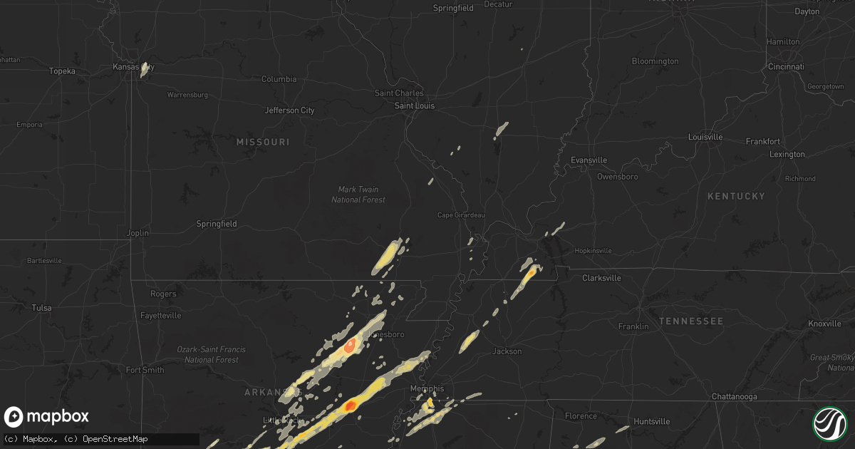
Hail Map in Tennessee on January 22, 2012
Get this storm
January 22 map
$229
one time, instant access
Download today. No call, no setup
Keep the $229
Bought the map and want the full workflow? Apply the entire $229 to a subscription within 7 days. None of it is wasted.
Every map, not just this one
This buys you this map. Subscription and you get every map we run, in the markets you choose from a few cities to whole states to nationwide. Plus real-time alerts the moment a storm fires.
Contact data
Name, contact info, occupancy, even credit band for addresses in the footprint. You go from where it hit to who to call.
Become the source they trust
Unlimited branding weather history reports on demand. You already have the documented answer ready for the property owner, and you are the one who showed up with it.
Property data and RoofTrace estimates
Pull up any address you have got, its value and the exact code rules for that jurisdiction, straight from One Click Code. Then RoofTrace estimates the squares, pitch, and roof value, priced the way you price.
Storm reports in Tennessee
Tennessee
| Date | Description |
|---|---|
| 01/22/20122:38 AM CST | Trees down at switchboard rd and womack rd near the community of oak grove. Road completely blocked. |
| 01/22/20122:36 AM CST | A few trees were downed across the county. |
| 01/22/20122:30 AM CST | A tree was reported downed on highway 64 east...coming from the i-24 wartrace area. |
| 01/22/20122:17 AM CST | A few trees were reported downed across the county. |
| 01/22/20122:08 AM CST | Tree down across road at crow cut road and old cox pike. |
| 01/22/20122:08 AM CST | A few trees were downed in the coopertown area. |
| 01/22/20122:05 AM CST | A couple of trees were reported downed across country roads. |
| 01/22/20122:03 AM CST | Tree down on hillboro rd and bobby drive |
| 01/22/20122:02 AM CST | Trees down on hillsboro rd across dody drive near fairview |
| 01/22/20121:55 AM CST | Trained spotter measures 62 mph gust 4 nw gallatin |
| 01/22/20121:50 AM CST | Power lines down at 1112 douglas place in gallatin. |
| 01/22/20121:46 AM CST | Tree blocking lane on new shackle road at long hollow pike. |
| 01/22/20121:36 AM CST | Trees blocking hwy 25 at halltown rd. |
| 01/22/20121:20 AM CST | Trained spotter reports trees down 2 m east of whitehouse at covington and cross plains rd. |
| 01/22/20121:16 AM CST | Amatuer radio operator reports multiple trees down and power lines blocking the road on hwy 48 n spanning from dickson to charlotte. |
| 01/22/20121:14 AM CST | Amatuer radio reports trees fallen on ups truck. Driver ok. Mm 161 eastbound i40. |
| 01/22/20121:08 AM CST | Amatuer radio operator reports trees down near hwy 70 at tennessee city. Hwy 48 n and steele rd. |
| 01/22/201212:55 AM CST | Trees and power lines were downed across portions of the county. |
| 01/22/201212:50 AM CST | Trained spotter reported estimated 60 mph gust 1 mile north of mm 163 on i40 |
| 01/22/201212:46 AM CST | Amateur radio reports measured 58 mph wind gust 18 m s of clarksville. |
| 01/22/201212:39 AM CST | In a field behind a residence on east humphries county line road in dickson...one thirty foot tree snapped aloft and another thrity foot tree uprooted...along with a fe |
| 01/22/201212:39 AM CST | Public report of possible tornado in the city of dickson. |
| 01/22/201212:35 AM CST | A few trees and power lines were downed across the county. |
| 01/22/201212:30 AM CST | Several trees were downed across the county. |
| 01/22/201212:21 AM CST | A few trees and power lines were downed across the county. |
| 01/21/201211:58 PM CST | Ef1 tornado with estimated winds of 105 mph touched down 5 miles south of lexington and continued east 8 miles. Numerous trees were uprooted or snapped along the path. |
| 01/21/201211:56 PM CST | Damage to structures in lexington. |
| 01/21/201211:55 PM CST | Powerlines down along us-70 in mason. |
| 01/21/201211:45 PM CST | Power lines were reported to have been peeled off a home in the southeastern part of the county. |
| 01/21/201211:33 PM CST | Trees down county wide. |
| 01/21/201211:15 PM CST | Estimated wind speed of 100 mph damaged numerous trees. Damage was focused in two locations. One just north of hickory valley and also near middleburg...tennesee. Occur |
| 01/21/201211:15 PM CST | Estimated wind speed of 100 mph damaged numerous trees. Damage was focused in two locations. One just north of hickory valley and also near middleburg...tennesee. Occur |
| 01/21/201211:14 PM CST | Trees down countywide. |
| 01/21/201211:12 PM CST | Trees on homes along hwy 18 south. |
| 01/21/201211:12 PM CST | Vehicle lodged in tree. |
| 01/21/201211:05 PM CST | Roof of metal barn blown off and one tree down. |
| 01/21/201211:03 PM CST | Tornado began at hazel ky to new providence ky. 100 yrds wide and 5.6 miles long. Pk wnd 95mph. Property damage 50k. Hundreds of trees uprooted/snapped. House with shin |
| 01/21/201210:40 PM CST | A local report indicates 58 MPH wind near GERMANTOWN |
| 01/21/201210:36 PM CST | Estimated 65 mph wind gust at national weather service forecast office. |
| 01/21/201210:36 PM CST | Estimated 65 mph wind gust at national weather service forecast office. |
| 01/21/201210:30 PM CST | Metal detachable garage blown over. |
| 01/21/201210:20 PM CST | Estimated wind speed of 105 mph lifted a large roof off a building and dropped it about 200 feet away across railroad tracks. Damage was just east of memphis airport ar |
| 01/21/201210:18 PM CST | Welcome to tennessee sign blown down on i-55 near the tennessee/mississippi state line |
| 01/21/201210:17 PM CST | Reported by weakley county ema. |
| 01/21/201210:15 PM CST | Carport destroyed |
| 01/21/201210:15 PM CST | Tree down on nailing drive |
| 01/21/201210:15 PM CST | A local report indicates 58 MPH wind near ATOKA |
All States Impacted by Hail Map on January 22, 2012
Cities Impacted by Hail Map on January 22, 2012
- Cotton Plant, AR
- Brinkley, AR
- Wheatley, AR
- Romance, AR
- Rose Bud, AR
- Searcy, AR
- Hampton, AR
- Royal, AR
- Bonnerdale, AR
- Chunky, MS
- Meridian, MS
- Collinsville, MS
- Bailey, MS
- Louann, AR
- Epes, AL
- Boligee, AL
- York, AL
- Livingston, AL
- Byhalia, MS
- Olive Branch, MS
- Lonoke, AR
- Perryville, MO
- Malvern, AR
- Winchester, AR
- Tillar, AR
- Monticello, AR
- Pickens, AR
- Poyen, AR
- Leola, AR
- Donaldson, AR
- Decatur, MS
- Camden, AR
- Smackover, AR
- Clanton, AL
- Wilmar, AR
- Fountain Hill, AR
- Joiner, AR
- Frenchmans Bayou, AR
- Tyronza, AR
- Bassett, AR
- Turrell, AR
- Earle, AR
- Gilmore, AR
- Alligator, MS
- Clarksdale, MS
- Shelby, MS
- Duncan, MS
- Bearden, AR
- Fordyce, AR
- Rosston, AR
- Chidester, AR
- Sarah, MS
- Coldwater, MS
- Kingsland, AR
- Sheridan, AR
- Redfield, AR
- Jefferson, AR
- Doniphan, MO
- Fairdealing, MO
- Grandin, MO
- Poplar Bluff, MO
- Ellsinore, MO
- Williamsville, MO
- Alexander, AR
- Benton, AR
- Grenada, MS
- Coffeeville, MS
- Tillatoba, MS
- Scobey, MS
- Sylacauga, AL
- Rockford, AL
- Weogufka, AL
- Benton, KY
- Hardin, KY
- Collierville, TN
- Magnolia, AR
- Traskwood, AR
- Bryant, AR
- Tunica, MS
- Imboden, AR
- Black Rock, AR
- Weiner, AR
- Little Rock, AR
- Pine Bluff, AR
- Ward, AR
- Drew, MS
- Tutwiler, MS
- Lyon, MS
- Gunnison, MS
- Vance, MS
- Lambert, MS
- Mound Bayou, MS
- Horn Lake, MS
- Lake Cormorant, MS
- Nesbit, MS
- Spruce Pine, AL
- Phil Campbell, AL
- Star City, AR
- Rison, AR
- Grady, AR
- Yorktown, AR
- Mayfield, KY
- Sedalia, KY
- Farmington, KY
- Kirksey, KY
- Trinity, AL
- Decatur, AL
- Tanner, AL
- Centreville, AL
- Maplesville, AL
- Thorsby, AL
- Randolph, AL
- Marion, AL
- Lawley, AL
- Des Arc, AR
- England, AR
- Wynne, AR
- Colt, AR
- Palestine, AR
- Humnoke, AR
- Biscoe, AR
- De Valls Bluff, AR
- Carlisle, AR
- Tucker, AR
- Stuttgart, AR
- Hazen, AR
- El Dorado, AR
- Vilonia, AR
- Conway, AR
- Mount Vernon, AR
- El Paso, AR
- Murray, KY
- Hazel, KY
- Gould, AR
- Altheimer, AR
- Waldo, AR
- Thornton, AR
- Ivan, AR
- Independence, MO
- Hermitage, AR
- Moulton, AL
- Southaven, MS
- Memphis, TN
- Dermott, AR
- Hamburg, AR
- Crossett, AR
- Strong, AR
- Jersey, AR
- Montrose, AR
- Garland City, AR
- Lewisville, AR
- Newport, AR
- Tuckerman, AR
- Hope, AR
- Emmet, AR
- Prescott, AR
- Rochester, IN
- Macy, IN
- Mount Hope, AL
- Dresden, TN
- Palmersville, TN
- Pocahontas, AR
- Scott, AR
- Beech Grove, AR
- Pleasant Plains, AR
- Alicia, AR
- Bono, AR
- Bradford, AR
- Swifton, AR
- Walnut Ridge, AR
- Cash, AR
- Judsonia, AR
- Thida, AR
- Oil Trough, AR
- Bald Knob, AR
- Philadelphia, MS
- De Kalb, MS
- Union, MS
- Hernando, MS
- Banks, AR
- Harrell, AR
- Halls, TN
- Gates, TN
- Brownsville, TN
- Ripley, TN
- Hodges, AL
- Senatobia, MS
- Dundee, MS
- Princeton, KY
- Fredonia, KY
- Kuttawa, KY
- Eddyville, KY
- Tuscaloosa, AL
- Adger, AL
- Brookwood, AL
- Northport, AL
- Arkadelphia, AR
- Prattsville, AR
- Walls, MS
- Robinsonville, MS
- Oxly, MO
- Waltonville, IL
- Corning, AR
- Wayland, MI
- Success, AR
- Gillett, AR
- Cuba, AL
- Lauderdale, MS
- Almyra, AR
- Logansport, IN
- Twelve Mile, IN
- Moro, AR
- Gurdon, AR
- Okolona, AR
- Coker, AL
- Charleston, MO
- Rosie, AR
- Sulphur Rock, AR
- Batesville, AR
- Ripley, MS
- Almo, KY
- Henning, TN
- Friendship, TN
- Tremont, MS
- Helena, AR
- Carrollton, AL
- Reform, AL
- Gordo, AL
- Cabot, AR
- North Little Rock, AR
- Jacksonville, AR
- Sherwood, AR
- Little Rock Air Force Base, AR
- Bellefontaine, MS
- Eupora, MS
- Cottage Grove, TN
- Letona, AR
- Pangburn, AR
- McRae, AR
- Harrisburg, AR
- Russellville, AL
- Town Creek, AL
- Puryear, TN
- Marion, MS
- Little Rock, MS
- Hickory, MS
- Floral, AR
- East Prairie, MO
- Alamo, TN
- Covington, TN
- Parkin, AR
- Fulton, MS
- Nettleton, MS
- Porterville, MS
- Bessemer, AL
- Oakman, AL
- Stewardson, IL
- Smithville, AR
- Mount Vernon, IL
- Rector, AR
- Lafe, AR
- Sawyerville, AL
- Forkland, AL
- Toomsuba, MS
- Peach Orchard, AR
- Delaplaine, AR
- Biggers, AR
- Charleston, MS
- Oakland, MS
- Kansas City, MO
- Kirby, AR
- Amity, AR
- Springville, AL
- Austin, AR
- Jonesboro, AR
- Bluff City, AR
- Mabelvale, AR
- Hensley, AR
- Vina, AL
- Amory, MS
- Hackleburg, AL
- Hamilton, AL
- Sharon, TN
- Rutherford, TN
- Dyer, TN
- Marked Tree, AR
- Goodwin, AR
- Cherry Valley, AR
- Wilson, AR
- Forrest City, AR
- Fisher, AR
- Corinth, MS
- Rienzi, MS
- Griffithville, AR
- Amagon, AR
- Merigold, MS
- Lees Summit, MO
- Bluford, IL
- Stamps, AR
- Taylor, AR
- De Witt, AR
- Warren, AR
- Trenton, TN
- Beebe, AR
- Heber Springs, AR
- Newark, AR
- Paragould, AR
- Greensboro, AL
- Brent, AL
- Newbern, AL
- Jemison, AL
- Ravenden Springs, AR
- Grand Junction, TN
- Moscow, TN
- Higginson, AR
- Watson, AR
- Steeleville, IL
- Sparta, IL
- Nashville, AR
- Moundville, AL
- Augusta, AR
- Cascilla, MS
- Pinson, AL
- Osceola, AR
- Clarendon, AR
- White Hall, AR
- Dyess, AR
- Gainesville, AL
- Fouke, AR
- Texarkana, AR
- New Edinburg, AR
- Buckner, AR
- Willisville, AR
- Waynesboro, MS
- Cord, AR
- Strawberry, AR
- Charlotte, AR
- Saffell, AR
- Harviell, MO
- Naylor, MO
- Crumrod, AR
- Fosters, AL
- Martin, TN
- Wappapello, MO
- Greenville, MO
- Holly Springs, MS
- Rossville, TN
- Glenwood, AR
- Ethel, AR
- Cutler, IL
- Coulterville, IL
- Gardendale, AL


