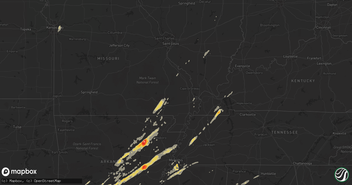
Hail Map on January 22, 2012
Get this storm
January 22 map
$229
one time, instant access
Download today. No call, no setup
Keep the $229
Bought the map and want the full workflow? Apply the entire $229 to a subscription within 7 days. None of it is wasted.
Every map, not just this one
This buys you this map. Subscription and you get every map we run, in the markets you choose from a few cities to whole states to nationwide. Plus real-time alerts the moment a storm fires.
Contact data
Name, contact info, occupancy, even credit band for addresses in the footprint. You go from where it hit to who to call.
Become the source they trust
Unlimited branding weather history reports on demand. You already have the documented answer ready for the property owner, and you are the one who showed up with it.
Property data and RoofTrace estimates
Pull up any address you have got, its value and the exact code rules for that jurisdiction, straight from One Click Code. Then RoofTrace estimates the squares, pitch, and roof value, priced the way you price.
States Impacted by Hail Map on January 22, 2012
Storm reports
Missouri
| Date | Description |
|---|---|
| 01/21/20129:16 PM CST | 60 mph winds and pea size hail reported in campbell. |
| 01/21/20129:12 PM CST | ...late report...camper overturned. Mobile home with roof blown off. |
| 01/21/20128:48 PM CST | Quarter size hail reported in the community. |
| 01/21/20128:34 PM CST | Power line down. |
Arkansas
| Date | Description |
|---|---|
| 01/21/201210:10 PM CST | Numerous reports of downed trees across northern ashley county. Also hail of unknown size. |
| 01/21/20129:55 PM CST | A local report indicates a tornado near SIMSBORO |
| 01/21/20129:45 PM CST | Tractor trailer overturned on us-49 near west helena. |
| 01/21/20129:45 PM CST | Tractor trailer overturned on us-49 near west helena. Numerous storage sheds also flipped over on the south side of the road |
| 01/21/20129:33 PM CST | Poinsett county oem reports quarter size hail and 50 mph winds just south of tyronza at hwy 118 along the crittenden/poinsett county line. |
| 01/21/20129:00 PM CST | Grain bins damaged on state highway 39 approximately 6 miles north of turner arkansas. Trees and part of a shop roof were blown off north of marvell arkansas on state h |
| 01/21/20128:59 PM CST | Tornado started 4 miles south of ragtown and ended 3.2 miles east of ragtown at the county border. The total path length of the storm was 5.8 miles and was rated an ef1 |
| 01/21/20128:55 PM CST | Law enforcement reports half dollar size hail 2 miles north of colt along the cross and st. Francis county line. |
| 01/21/20128:52 PM CST | St. Francis county office of emergency management reports quarter size hail west of colt near ar 306 and ar 193. |
| 01/21/20128:51 PM CST | An ef1 tornado touched down 8.2 miles south of de witt...and continued 9.4 miles to 3 miles se of de witt. This tornado remained in arkansas county...with trees...power |
| 01/21/20128:40 PM CST | Trailer house destroyed on garot road south of de witt. |
| 01/21/20128:38 PM CST | Tornado reported on the ground 1 mile west of burks. |
| 01/21/20128:37 PM CST | A camper and a storage building were destroyed. |
| 01/21/20128:36 PM CST | The ef2 tornado touched down 5.5 miles wnw of de witt...and continued 14.4 miles to near crocketts bluff. This tornado remained in arkansas county...with four steel tra |
| 01/21/20128:36 PM CST | Tornado reported on the ground by storm chasers 4 miles northwest of de witt. |
| 01/21/20128:36 PM CST | A shed and duck blind were demolished on stroh road. |
| 01/21/20128:33 PM CST | Tornado reported on the ground by storm chasers 4 miles northwest of de witt. |
| 01/21/20128:33 PM CST | A local report indicates 1.25 inch wind near 12 N STUTTGART |
| 01/21/20128:30 PM CST | A local report indicates 2.75 inch wind near BRINKLEY |
| 01/21/20128:30 PM CST | Law enforcement reported a tornado on the ground at the junction of highways 11 and 165 two miles east of lodge corner. |
| 01/21/20128:29 PM CST | Tree down blocking highway 226 spur in southwest jonesboro |
| 01/21/20128:26 PM CST | A local report indicates 1.75 inch wind near BRINKLEY |
| 01/21/20128:15 PM CST | A local report indicates 2.75 inch wind near GRIFFITH SPRING |
| 01/21/20128:15 PM CST | The ef2 tornado touched down in sweden...and continued 16.9 miles to 3.45 ne of lodge corner...affecting jefferson and arkansas counties. In jefferson county...numerous |
| 01/21/20128:10 PM CST | A local report indicates 2.75 inch wind near 1 NW HOOKER |
| 01/21/20128:10 PM CST | A local report indicates 1.25 inch wind near HOOKER |
| 01/21/20128:06 PM CST | The starting point of the tornado was 2.7 miles wsw of moscow and ended 1.2 miles ne of moscow for a total path length of 3.8 miles. This tornado was rated an ef1. Dama |
| 01/21/20128:00 PM CST | Trees were blown down. |
| 01/21/20128:00 PM CST | Golf ball to baseball size hail reported in newport |
| 01/21/20128:00 PM CST | Golf ball to baseball size hail reported in newport |
| 01/21/20127:59 PM CST | Amateur radio operator reports a tornado on the ground 2 miles north of slovak. |
| 01/21/20127:56 PM CST | A local report indicates 1.75 inch wind near PINEBERGEN |
| 01/21/20127:40 PM CST | Tree limbs and other debris reported across highway 371. |
| 01/21/20127:40 PM CST | Amateur radio operator reported a brief tornado touchdowwn 5 miles west of coy |
| 01/21/20127:38 PM CST | Quarter size hail reported by craighead county emergency management near the intersection of routes 226 and 67 near cash. |
| 01/21/20127:30 PM CST | A local report indicates 1.50 inch wind near ENGLAND |
| 01/21/20127:30 PM CST | Amateuer operator reporting some hail stones the size of saoftballs. |
| 01/21/20127:28 PM CST | This tornado started 2.5 miles sw of coy and ended 1.7 miles sw of coy for a total path length of three quarters of a mile and was rated an ef1. Damage found included a |
| 01/21/20127:26 PM CST | 2 houses damagaed on highway 8 northwest of fordyce. No injuries reported at this time. |
| 01/21/20127:26 PM CST | Quarter size hail reported by lawrence county sheriffs office in black rock. |
| 01/21/20127:26 PM CST | Tornado reported on the ground by law enforcement4 miles northeast of fordyce. |
| 01/21/20127:15 PM CST | A local report indicates 1.00 inch wind near NEWPORT |
| 01/21/20127:15 PM CST | A local report indicates 1.00 inch wind near NEWPORT |
| 01/21/20127:15 PM CST | A local report indicates 2.75 inch wind near TUCKERMAN |
| 01/21/20127:15 PM CST | Hail cracked the windshield of the amatuer radio operator. |
| 01/21/20127:14 PM CST | The ef2 tornado touched down 3 wsw of thornton and continued 19.2 miles to 4.9 sw of rison...affecting calhoun...dallas and cleveland counties. In calhoun county...dama |
| 01/21/20127:13 PM CST | Several trees were blown down near highway 31. |
| 01/21/20127:10 PM CST | A local report indicates 1.75 inch wind near OIL TROUGH |
| 01/21/20127:10 PM CST | A local report indicates 1.00 inch wind near CABOT |
| 01/21/20127:04 PM CST | A local report indicates 1.25 inch wind near 12 S FORDYCE |
| 01/21/20127:03 PM CST | A local report indicates 1.00 inch wind near JACKSONVILLE |
| 01/21/20127:02 PM CST | Trees down at white oak lake across highway 57 |
| 01/21/20126:52 PM CST | A local report indicates 1.00 inch wind near 1 N GRAVEL RIDGE |
| 01/21/20126:45 PM CST | Report of two damaged chicken houses on cr 1310 between ozan and nashville. |
| 01/21/20126:30 PM CST | A few trees reported down. |
| 01/21/20126:29 PM CST | A local report indicates 1.50 inch wind near MALVERN |
| 01/21/20126:29 PM CST | A local report indicates 1.00 inch wind near 8 N SEARCY |
| 01/21/20126:19 PM CST | Quarter to half dollar size hail reported in gravel hill. |
Illinois
| Date | Description |
|---|---|
| 01/21/201210:30 PM CST | Late report. |
| 01/21/201210:20 PM CST | Delayed report. Tree blown down on route 130 west of hugo blocking one lane of traffic. |
| 01/21/201210:17 PM CST | A local report indicates 58 MPH wind near HARRISBURG |
| 01/21/201210:12 PM CST | Large tree down. |
| 01/21/201210:05 PM CST | Downed trees with standing water on roadways along dutchman lake road. |
| 01/21/201210:05 PM CST | A local report indicates 60 MPH wind near ROUND KNOB |
| 01/21/20129:47 PM CST | A local report indicates 1.00 inch wind near MOUNT VERNON |
| 01/21/20129:38 PM CST | Half dollar size hail reported in the community. |
| 01/21/20129:23 PM CST | 60 mph wind gust reported on west side of town. |
| 01/21/20129:12 PM CST | 60 mph wind gust reported on west side of town. |
Kentucky
| Date | Description |
|---|---|
| 01/22/20123:00 AM CST | Casey county department of highways reported a few trees down throughout the county. |
| 01/22/20122:50 AM CST | A few trees down on cross pike near parksville. |
| 01/22/20122:24 AM CST | One tree down near riley |
| 01/22/20121:42 AM CST | Scattered trees down around the county |
| 01/22/20121:25 AM CST | Vehicle damage from downed trees |
| 01/22/20121:25 AM CST | Power line down and transformer blown |
| 01/22/20121:23 AM CST | A local report indicates 59 MPH wind near 5 SSW FRANKLIN |
| 01/22/20121:23 AM CST | Power outages |
| 01/22/20121:15 AM CST | Power outages in the city |
| 01/22/20121:12 AM CST | Two trees reported down. |
| 01/22/201212:40 AM CST | Few trees reported down across county. |
| 01/22/201212:37 AM CST | Two trees were downed across roads in the county. One large tree fell across holt road 2 miles east of cloversport. The other fell just west of hardinsburg near the int |
| 01/22/201212:35 AM CST | Roof blown off a mobile home and blown into power lines which were downed. |
| 01/22/201212:19 AM CST | Tree down across hwy 69 |
| 01/22/201212:14 AM CST | Barn blown away along hwy 334 |
| 01/22/201212:14 AM CST | Storage building destroyed and roof damage to a few homes |
| 01/22/201212:05 AM CST | ...late report...mobile home received extensive damage along old state road. |
| 01/22/201212:01 AM CST | ...minor injuries to occupants...house received major damage...one or more barns destroyed. Trees down along highway 81. |
| 01/22/201212:01 AM CST | Over 1500 electrical customers without power in the communities of sebree...poole and slaughters. |
| 01/21/201211:55 PM CST | A local report indicates 63 MPH wind near 6 N HOPKINSVILLE |
| 01/21/201211:45 PM CST | 1 mobile home destroyed on the west side of highway 81 northeast of calhoun. |
| 01/21/201211:42 PM CST | 1 barn destroyed in north central mclean county less than 1 mile from the mclean-daviess county line. |
| 01/21/201211:40 PM CST | Several mobile homes destroyed and many trees blown over along a 6 to 7 mile swath across the county. One mobile home was left in the middle of brooks schoolhouse road |
| 01/21/201211:30 PM CST | A local report indicates 60 MPH wind near DAWSON SPRINGS |
| 01/21/201211:30 PM CST | 200 customers without power. |
| 01/21/201211:25 PM CST | Power outages. |
| 01/21/201211:25 PM CST | Late report...large trees down or uprooted along niles road. |
| 01/21/201211:25 PM CST | Power outages. Utility company reports nearly 1000 customers affected in hopkins and christian counties. |
| 01/21/201211:25 PM CST | Power outages reported. |
| 01/21/201211:14 PM CST | Marble size hail reported with this storm. |
| 01/21/201211:09 PM CST | Hail the size of hen eggs reported just southwest of town. |
| 01/21/201211:05 PM CST | Late report...damage along craig road. Numerous trees down...gutters pulled off of one home which had several windows blown out. Large tree fell across a truck. |
| 01/21/201211:05 PM CST | Quarter size hail reported. |
| 01/21/201210:40 PM CST | Power outages reported. Approximately 20 customers affected. |
| 01/21/201210:20 PM CST | Downed trees blocking rufuge road. |
| 01/21/20129:58 PM CST | Widespread power outages...up to 296 customers affected. |
| 01/21/20129:53 PM CST | Downed radio/tv antenna. |
Alabama
| Date | Description |
|---|---|
| 01/22/20125:47 AM CST | Trees and power lines down on alabama highway 76 near desoto caverns park. |
| 01/22/20125:37 AM CST | One home had one-fifth of its roof peeled off. A dozen pine trees were uprooted near lee road and highway 76. Possible tornado. |
| 01/22/20125:35 AM CST | The tornado touched down just west of the intersection of al-76 and cr-175 oakdale road...and moved ene from there...remaining very close to al-76. A house and storage |
| 01/22/20125:20 AM CST | Wklf radio studio destroyed...and 302 foot transmission tower was toppled at the intersection of alabama highway 22 and county road 37. The strength of the tornado was |
| 01/22/20125:05 AM CST | Major structual damage reported in maplesville with people trapped in homes. |
| 01/22/20124:50 AM CST | Major stuctural damage reported near the 500 block of u.s. Highway 31 in fultondale. |
| 01/22/20124:37 AM CST | Multiple trees down blocking the roadway on the intersection of alabama highway 5 and county road 16. Possible tornado. |
| 01/22/20124:36 AM CST | Possible tornado - cr hwy 183- many trees blocking hwy sprott to sr 82 - oakmulgee damage as well |
| 01/22/20124:29 AM CST | Major structual damage reported on old springville road. Injuries unknown at this time. |
| 01/22/20124:27 AM CST | Major structural damage reported in trussville with multiple trees downed. |
| 01/22/20124:17 AM CST | Public reported a tornado on roulain road in the margaret community. |
| 01/22/20124:15 AM CST | Trees down and damage to homes near balboa court. |
| 01/22/20124:11 AM CST | Extensive damage with multiple trees and power lines down in center point. Possible tornado. |
| 01/22/20124:10 AM CST | Several homes destroyed in the paradise valley area in clay. Time estimated from radar. |
| 01/22/20124:05 AM CST | Quarter size hail reported in center point. |
| 01/22/20124:00 AM CST | Structure damage and numerous trees down in the 8800 block of taylors ferry road. Possible tornado. |
| 01/22/20124:00 AM CST | Pawnee village road completely impassible in tarrant. |
| 01/22/20123:54 AM CST | Major stuctural damage reported near the 500 block of u.s. Highway 31 in fultondale. |
| 01/22/20123:43 AM CST | Trees down blocking camp oliver road by stringfellow hill road west of oak grove. |
| 01/22/20123:31 AM CST | Trees down across taylors ferry road. Possible tornado. |
| 01/22/20123:26 AM CST | Trees down on toadvine road. Possible tornado. |
| 01/22/20123:24 AM CST | Multiple trees down on taylors ferry road. |
| 01/22/20123:23 AM CST | Reports of trees down and possible structural damage near smithville baptist church on toadvine road near oak grove. Possible tornado. Time estimated from radar. |
| 01/22/20123:21 AM CST | Several trees were snapped off or uprooted and a shed was destroyed.the path length was about 1 mile and the width was 50 yards. This occurred near highway 11 and count |
| 01/22/20123:20 AM CST | Several trees blown were down and a shed destroyed. |
| 01/22/20123:20 AM CST | Several trees were snapped off or uprooted and a shed was destroyed.the path length was about 1 mile and the width was 50 yards. This occurred near highway 11 and count |
| 01/22/20123:09 AM CST | *** 1 fatal *** the tornado started in extreme eastern tuscaloosa county and moved into jefferson county. Numerous trees were snapped off and uprooted along the path. O |
| 01/22/20123:09 AM CST | Roof reported off a home on gray drive in the mount olive community. Possible tornado. |
| 01/22/20123:00 AM CST | F2 tornado on watermelon road. Dozens of pines were snapped and several campers were rolled over. 3 h-frame transmission lines were snapped. The path was about one half |
| 01/22/20122:45 AM CST | Large trees down blocking the roadway on larry lake road...as well as a roof ripped off a home in the mount olive area of coker. |
| 01/22/20122:45 AM CST | Tornado spotted on the ground on lake tuscaloosa tierce patton road. |
| 01/22/20122:40 AM CST | Huge trees down on state highway 171 near crawford drive. Possible tornado. |
| 01/22/20122:40 AM CST | Dozens of trees were uprooted near koffman ranch road. One well constructed single family home lost its entie roof. The path length was about one half mile and was 400 |
| 01/22/20122:36 AM CST | Significant damage to a home off of marby heights drive. Possible tornado. |
| 01/22/20122:36 AM CST | The tornado touched down along s h and g drive causing significant roof damage to one single family residence. As the tornado continued northeast towards marby heights |
| 01/22/20122:25 AM CST | Trees down on highway 140 and holeman church road. Time estimated from radar. |
| 01/22/20121:15 AM CST | Brief quarter sized hail was reported. |
| 01/22/201212:34 AM CST | Tree knocked down on hwy 172 near bear creek bridge. |
Indiana
| Date | Description |
|---|---|
| 01/22/201212:40 AM CST | Part of the roof of nashville elementary school was tore off allowing water damage to some classrooms. Time estimated. |
| 01/22/201212:37 AM CST | Power outages in english. Dispatch reported power outages in grantsburg. |
| 01/22/201212:19 AM CST | Roof blown off building into road and several power outages |
| 01/22/201212:17 AM CST | Tree and utility line down at state road 550 and evans road just outside of wheatland. Time estimated. |
| 01/22/201212:15 AM CST | Garage door was blown in. Time estimated. |
| 01/22/201212:00 AM CST | Trees were blown down. Time estimated. |
| 01/22/201212:00 AM CST | Trees were blown down. Time estimated. |
| 01/21/201211:54 PM CST | A local report indicates 60 MPH wind near 1 SE IRELAND |
| 01/21/201211:48 PM CST | A local report indicates 58 MPH wind near CHANDLER |
| 01/21/201211:45 PM CST | Unspecified and unconfirmed damage |
| 01/21/201211:45 PM CST | House and turkey barns destroyed at 4930 north and 350 west. One wall left standing of house. Reference city and direction/distance is estimated. |
| 01/21/201211:43 PM CST | A local report indicates 58 MPH wind near CHANDLER |
| 01/21/201211:30 PM CST | Shingles were blown off a roof by measured 60 mph winds. |
| 01/21/201211:30 PM CST | Shingles were blown off a roof |
| 01/21/201211:30 PM CST | A local report indicates 58 MPH wind near CHANDLER |
| 01/21/201211:28 PM CST | A local report indicates 60 MPH wind near ST. PHILLIP |
| 01/21/201211:17 PM CST | Tree and utility line down at state road 550 and evans road just outside of wheatland. Time estimated. |
| 01/21/201211:15 PM CST | Winds of 60 plus mph reported in town. |
| 01/21/201211:15 PM CST | A few trees reported down throughout the community. |
| 01/21/201211:04 PM CST | A local report indicates 61 MPH wind near MOUNT VERNON |
| 01/21/201210:56 PM CST | A local report indicates 61 MPH wind near MOUNT VERNON |
| 01/21/201210:52 PM CST | Late report. |
| 01/21/201210:52 PM CST | A local report indicates 60 MPH wind near 3 W POSEYVILLE |
Tennessee
| Date | Description |
|---|---|
| 01/22/20122:38 AM CST | Trees down at switchboard rd and womack rd near the community of oak grove. Road completely blocked. |
| 01/22/20122:36 AM CST | A few trees were downed across the county. |
| 01/22/20122:30 AM CST | A tree was reported downed on highway 64 east...coming from the i-24 wartrace area. |
| 01/22/20122:17 AM CST | A few trees were reported downed across the county. |
| 01/22/20122:08 AM CST | Tree down across road at crow cut road and old cox pike. |
| 01/22/20122:08 AM CST | A few trees were downed in the coopertown area. |
| 01/22/20122:05 AM CST | A couple of trees were reported downed across country roads. |
| 01/22/20122:03 AM CST | Tree down on hillboro rd and bobby drive |
| 01/22/20122:02 AM CST | Trees down on hillsboro rd across dody drive near fairview |
| 01/22/20121:55 AM CST | Trained spotter measures 62 mph gust 4 nw gallatin |
| 01/22/20121:50 AM CST | Power lines down at 1112 douglas place in gallatin. |
| 01/22/20121:46 AM CST | Tree blocking lane on new shackle road at long hollow pike. |
| 01/22/20121:36 AM CST | Trees blocking hwy 25 at halltown rd. |
| 01/22/20121:20 AM CST | Trained spotter reports trees down 2 m east of whitehouse at covington and cross plains rd. |
| 01/22/20121:16 AM CST | Amatuer radio operator reports multiple trees down and power lines blocking the road on hwy 48 n spanning from dickson to charlotte. |
| 01/22/20121:14 AM CST | Amatuer radio reports trees fallen on ups truck. Driver ok. Mm 161 eastbound i40. |
| 01/22/20121:08 AM CST | Amatuer radio operator reports trees down near hwy 70 at tennessee city. Hwy 48 n and steele rd. |
| 01/22/201212:55 AM CST | Trees and power lines were downed across portions of the county. |
| 01/22/201212:50 AM CST | Trained spotter reported estimated 60 mph gust 1 mile north of mm 163 on i40 |
| 01/22/201212:46 AM CST | Amateur radio reports measured 58 mph wind gust 18 m s of clarksville. |
| 01/22/201212:39 AM CST | In a field behind a residence on east humphries county line road in dickson...one thirty foot tree snapped aloft and another thrity foot tree uprooted...along with a fe |
| 01/22/201212:39 AM CST | Public report of possible tornado in the city of dickson. |
| 01/22/201212:35 AM CST | A few trees and power lines were downed across the county. |
| 01/22/201212:30 AM CST | Several trees were downed across the county. |
| 01/22/201212:21 AM CST | A few trees and power lines were downed across the county. |
| 01/21/201211:58 PM CST | Ef1 tornado with estimated winds of 105 mph touched down 5 miles south of lexington and continued east 8 miles. Numerous trees were uprooted or snapped along the path. |
| 01/21/201211:56 PM CST | Damage to structures in lexington. |
| 01/21/201211:55 PM CST | Powerlines down along us-70 in mason. |
| 01/21/201211:45 PM CST | Power lines were reported to have been peeled off a home in the southeastern part of the county. |
| 01/21/201211:33 PM CST | Trees down county wide. |
| 01/21/201211:15 PM CST | Estimated wind speed of 100 mph damaged numerous trees. Damage was focused in two locations. One just north of hickory valley and also near middleburg...tennesee. Occur |
| 01/21/201211:15 PM CST | Estimated wind speed of 100 mph damaged numerous trees. Damage was focused in two locations. One just north of hickory valley and also near middleburg...tennesee. Occur |
| 01/21/201211:14 PM CST | Trees down countywide. |
| 01/21/201211:12 PM CST | Vehicle lodged in tree. |
| 01/21/201211:12 PM CST | Trees on homes along hwy 18 south. |
| 01/21/201211:05 PM CST | Roof of metal barn blown off and one tree down. |
| 01/21/201211:03 PM CST | Tornado began at hazel ky to new providence ky. 100 yrds wide and 5.6 miles long. Pk wnd 95mph. Property damage 50k. Hundreds of trees uprooted/snapped. House with shin |
| 01/21/201210:40 PM CST | A local report indicates 58 MPH wind near GERMANTOWN |
| 01/21/201210:36 PM CST | Estimated 65 mph wind gust at national weather service forecast office. |
| 01/21/201210:36 PM CST | Estimated 65 mph wind gust at national weather service forecast office. |
| 01/21/201210:30 PM CST | Metal detachable garage blown over. |
| 01/21/201210:20 PM CST | Estimated wind speed of 105 mph lifted a large roof off a building and dropped it about 200 feet away across railroad tracks. Damage was just east of memphis airport ar |
| 01/21/201210:18 PM CST | Welcome to tennessee sign blown down on i-55 near the tennessee/mississippi state line |
| 01/21/201210:17 PM CST | Reported by weakley county ema. |
| 01/21/201210:15 PM CST | Carport destroyed |
| 01/21/201210:15 PM CST | A local report indicates 58 MPH wind near ATOKA |
| 01/21/201210:15 PM CST | Tree down on nailing drive |
Mississippi
| Date | Description |
|---|---|
| 01/22/20123:25 AM CST | Few trees down |
| 01/22/20122:53 AM CST | Lauderdale county ema reports they have received numerous public reports of a tornado on the ground in ne lauderdale county between the lockhart and lauderdale communit |
| 01/22/20122:45 AM CST | Mobile home damaged and trees and powerlines down on sam lackey road. Update from emergency manager...a few trees were snapped and uprooted and there was shingle damage |
| 01/22/20122:35 AM CST | In the bailey community |
| 01/22/20122:30 AM CST | Several pine trees blown over |
| 01/22/20121:25 AM CST | Tree down on house on pegg street and another tree down near gore springs community |
| 01/22/20121:22 AM CST | Trees and powerlines down |
| 01/22/20121:15 AM CST | Awning blown off gas station near union |
| 01/22/20121:15 AM CST | Awning blown off gas station near union |
| 01/22/20121:03 AM CST | Couple of trees down near morton |
| 01/21/201211:55 PM CST | In the elizabeth community...mobile home with some damage...trees and powerlines down...carport blown away |
| 01/21/201211:20 PM CST | Trained spotter reported tornado on the ground near trebloc. |
| 01/21/201211:00 PM CST | About 7 homes damaged from shingles being torn off...uplift of small portion of roofing material...garage door blown out and numerous windows broken. The tornado first |
| 01/21/201211:00 PM CST | Heavy damage to a home garage...4 to 5 homes on the same street damaged. Metal roof and columns torn off of one home. Power lines and power poles down. |
| 01/21/201210:41 PM CST | Trees down 6 miles south of byhalia. |
| 01/21/201210:37 PM CST | Quarter to golf ball sized hail...likely driven by wind...broke some windows |
| 01/21/201210:35 PM CST | Large limbs down...fence blown apart...some shingle damage to houses...numerous trees down in area including on magnolia hill |
| 01/21/201210:35 PM CST | Updated info...11 mobile homes were damaged or destroyed...numerous powerlines down...possible tornado |
| 01/21/201210:34 PM CST | *** 1 inj *** nws storm survey determines an ef-2 tornado with max est winds of 120 mph caused substantial damage in extreme ne bolivar county. Path length 3.75 mi...ma |
| 01/21/201210:30 PM CST | Report of hail up to the size of golfballs on church road between getwell and pleasant hill road. |
| 01/21/201210:30 PM CST | Large limbs down...fence blown apart...some shingle damage to houses |
| 01/21/201210:23 PM CST | A local report indicates 1.00 inch wind near 7 S HERNANDO |
| 01/21/201210:18 PM CST | Debris on roadway on i-55 at mile marker 275...and northbound church road exit sign on i-55 blown down. |
| 01/21/201210:05 PM CST | Power lines down near robinsonville |
| 01/21/201210:00 PM CST | 3 grain elevator bins and farm shop heavily damaged on new africa road northeast of town of alligator. |
| 01/21/20129:55 PM CST | Trailer home moved off slab foundation on bellvue road hwy 322 just outside clarksdale city limits. |
Cities Impacted by Hail Map on January 22, 2012
- Cotton Plant, AR
- Brinkley, AR
- Wheatley, AR
- Romance, AR
- Rose Bud, AR
- Searcy, AR
- Hampton, AR
- Royal, AR
- Bonnerdale, AR
- Chunky, MS
- Meridian, MS
- Collinsville, MS
- Bailey, MS
- Louann, AR
- Epes, AL
- Boligee, AL
- York, AL
- Livingston, AL
- Byhalia, MS
- Olive Branch, MS
- Lonoke, AR
- Perryville, MO
- Malvern, AR
- Winchester, AR
- Tillar, AR
- Monticello, AR
- Pickens, AR
- Poyen, AR
- Leola, AR
- Donaldson, AR
- Decatur, MS
- Camden, AR
- Smackover, AR
- Clanton, AL
- Wilmar, AR
- Fountain Hill, AR
- Joiner, AR
- Frenchmans Bayou, AR
- Tyronza, AR
- Bassett, AR
- Turrell, AR
- Earle, AR
- Gilmore, AR
- Alligator, MS
- Clarksdale, MS
- Shelby, MS
- Duncan, MS
- Bearden, AR
- Fordyce, AR
- Rosston, AR
- Chidester, AR
- Sarah, MS
- Coldwater, MS
- Kingsland, AR
- Sheridan, AR
- Redfield, AR
- Jefferson, AR
- Doniphan, MO
- Fairdealing, MO
- Grandin, MO
- Poplar Bluff, MO
- Ellsinore, MO
- Williamsville, MO
- Alexander, AR
- Benton, AR
- Grenada, MS
- Coffeeville, MS
- Tillatoba, MS
- Scobey, MS
- Sylacauga, AL
- Rockford, AL
- Weogufka, AL
- Benton, KY
- Hardin, KY
- Collierville, TN
- Magnolia, AR
- Traskwood, AR
- Bryant, AR
- Tunica, MS
- Imboden, AR
- Black Rock, AR
- Weiner, AR
- Little Rock, AR
- Pine Bluff, AR
- Ward, AR
- Drew, MS
- Tutwiler, MS
- Lyon, MS
- Gunnison, MS
- Vance, MS
- Lambert, MS
- Mound Bayou, MS
- Horn Lake, MS
- Lake Cormorant, MS
- Nesbit, MS
- Spruce Pine, AL
- Phil Campbell, AL
- Star City, AR
- Rison, AR
- Grady, AR
- Yorktown, AR
- Mayfield, KY
- Sedalia, KY
- Farmington, KY
- Kirksey, KY
- Trinity, AL
- Decatur, AL
- Tanner, AL
- Centreville, AL
- Maplesville, AL
- Thorsby, AL
- Randolph, AL
- Marion, AL
- Lawley, AL
- Des Arc, AR
- England, AR
- Wynne, AR
- Colt, AR
- Palestine, AR
- Humnoke, AR
- Biscoe, AR
- De Valls Bluff, AR
- Carlisle, AR
- Tucker, AR
- Stuttgart, AR
- Hazen, AR
- El Dorado, AR
- Vilonia, AR
- Conway, AR
- Mount Vernon, AR
- El Paso, AR
- Murray, KY
- Hazel, KY
- Gould, AR
- Altheimer, AR
- Waldo, AR
- Thornton, AR
- Ivan, AR
- Independence, MO
- Hermitage, AR
- Moulton, AL
- Southaven, MS
- Memphis, TN
- Dermott, AR
- Hamburg, AR
- Crossett, AR
- Strong, AR
- Jersey, AR
- Montrose, AR
- Garland City, AR
- Lewisville, AR
- Newport, AR
- Tuckerman, AR
- Hope, AR
- Emmet, AR
- Prescott, AR
- Rochester, IN
- Macy, IN
- Mount Hope, AL
- Dresden, TN
- Palmersville, TN
- Pocahontas, AR
- Scott, AR
- Beech Grove, AR
- Pleasant Plains, AR
- Alicia, AR
- Bono, AR
- Bradford, AR
- Swifton, AR
- Walnut Ridge, AR
- Cash, AR
- Judsonia, AR
- Thida, AR
- Oil Trough, AR
- Bald Knob, AR
- Philadelphia, MS
- De Kalb, MS
- Union, MS
- Hernando, MS
- Banks, AR
- Harrell, AR
- Halls, TN
- Gates, TN
- Brownsville, TN
- Ripley, TN
- Hodges, AL
- Senatobia, MS
- Dundee, MS
- Princeton, KY
- Fredonia, KY
- Kuttawa, KY
- Eddyville, KY
- Tuscaloosa, AL
- Adger, AL
- Brookwood, AL
- Northport, AL
- Arkadelphia, AR
- Prattsville, AR
- Walls, MS
- Robinsonville, MS
- Oxly, MO
- Waltonville, IL
- Corning, AR
- Wayland, MI
- Success, AR
- Gillett, AR
- Cuba, AL
- Lauderdale, MS
- Almyra, AR
- Logansport, IN
- Twelve Mile, IN
- Moro, AR
- Gurdon, AR
- Okolona, AR
- Coker, AL
- Charleston, MO
- Rosie, AR
- Sulphur Rock, AR
- Batesville, AR
- Ripley, MS
- Almo, KY
- Henning, TN
- Friendship, TN
- Tremont, MS
- Helena, AR
- Carrollton, AL
- Reform, AL
- Gordo, AL
- Cabot, AR
- North Little Rock, AR
- Jacksonville, AR
- Sherwood, AR
- Little Rock Air Force Base, AR
- Bellefontaine, MS
- Eupora, MS
- Cottage Grove, TN
- Letona, AR
- Pangburn, AR
- McRae, AR
- Harrisburg, AR
- Russellville, AL
- Town Creek, AL
- Puryear, TN
- Marion, MS
- Little Rock, MS
- Hickory, MS
- Floral, AR
- East Prairie, MO
- Alamo, TN
- Covington, TN
- Parkin, AR
- Fulton, MS
- Nettleton, MS
- Porterville, MS
- Bessemer, AL
- Oakman, AL
- Stewardson, IL
- Smithville, AR
- Mount Vernon, IL
- Rector, AR
- Lafe, AR
- Sawyerville, AL
- Forkland, AL
- Toomsuba, MS
- Peach Orchard, AR
- Delaplaine, AR
- Biggers, AR
- Charleston, MS
- Oakland, MS
- Kansas City, MO
- Kirby, AR
- Amity, AR
- Springville, AL
- Austin, AR
- Jonesboro, AR
- Bluff City, AR
- Mabelvale, AR
- Hensley, AR
- Vina, AL
- Amory, MS
- Hackleburg, AL
- Hamilton, AL
- Sharon, TN
- Rutherford, TN
- Dyer, TN
- Marked Tree, AR
- Goodwin, AR
- Cherry Valley, AR
- Wilson, AR
- Forrest City, AR
- Fisher, AR
- Corinth, MS
- Rienzi, MS
- Griffithville, AR
- Amagon, AR
- Merigold, MS
- Lees Summit, MO
- Bluford, IL
- Stamps, AR
- Taylor, AR
- De Witt, AR
- Warren, AR
- Trenton, TN
- Beebe, AR
- Heber Springs, AR
- Newark, AR
- Paragould, AR
- Greensboro, AL
- Brent, AL
- Newbern, AL
- Jemison, AL
- Ravenden Springs, AR
- Grand Junction, TN
- Moscow, TN
- Higginson, AR
- Watson, AR
- Steeleville, IL
- Sparta, IL
- Nashville, AR
- Moundville, AL
- Augusta, AR
- Cascilla, MS
- Pinson, AL
- Osceola, AR
- Clarendon, AR
- White Hall, AR
- Dyess, AR
- Gainesville, AL
- Fouke, AR
- Texarkana, AR
- New Edinburg, AR
- Buckner, AR
- Willisville, AR
- Waynesboro, MS
- Cord, AR
- Strawberry, AR
- Charlotte, AR
- Saffell, AR
- Harviell, MO
- Naylor, MO
- Crumrod, AR
- Fosters, AL
- Martin, TN
- Wappapello, MO
- Greenville, MO
- Holly Springs, MS
- Rossville, TN
- Glenwood, AR
- Ethel, AR
- Cutler, IL
- Coulterville, IL
- Gardendale, AL