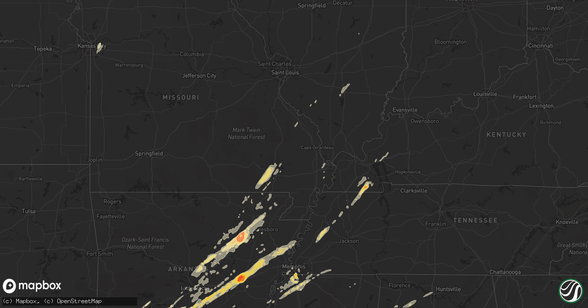
Hail Map in Arkansas on January 22, 2012
Get this storm
January 22 map
$229
one time, instant access
Download today. No call, no setup
Keep the $229
Bought the map and want the full workflow? Apply the entire $229 to a subscription within 7 days. None of it is wasted.
Every map, not just this one
This buys you this map. Subscription and you get every map we run, in the markets you choose from a few cities to whole states to nationwide. Plus real-time alerts the moment a storm fires.
Contact data
Name, contact info, occupancy, even credit band for addresses in the footprint. You go from where it hit to who to call.
Become the source they trust
Unlimited branding weather history reports on demand. You already have the documented answer ready for the property owner, and you are the one who showed up with it.
Property data and RoofTrace estimates
Pull up any address you have got, its value and the exact code rules for that jurisdiction, straight from One Click Code. Then RoofTrace estimates the squares, pitch, and roof value, priced the way you price.
Storm reports in Arkansas
Arkansas
| Date | Description |
|---|---|
| 01/21/201210:10 PM CST | Numerous reports of downed trees across northern ashley county. Also hail of unknown size. |
| 01/21/20129:55 PM CST | A local report indicates a tornado near SIMSBORO |
| 01/21/20129:45 PM CST | Tractor trailer overturned on us-49 near west helena. |
| 01/21/20129:45 PM CST | Tractor trailer overturned on us-49 near west helena. Numerous storage sheds also flipped over on the south side of the road |
| 01/21/20129:33 PM CST | Poinsett county oem reports quarter size hail and 50 mph winds just south of tyronza at hwy 118 along the crittenden/poinsett county line. |
| 01/21/20129:00 PM CST | Grain bins damaged on state highway 39 approximately 6 miles north of turner arkansas. Trees and part of a shop roof were blown off north of marvell arkansas on state h |
| 01/21/20128:59 PM CST | Tornado started 4 miles south of ragtown and ended 3.2 miles east of ragtown at the county border. The total path length of the storm was 5.8 miles and was rated an ef1 |
| 01/21/20128:55 PM CST | Law enforcement reports half dollar size hail 2 miles north of colt along the cross and st. Francis county line. |
| 01/21/20128:52 PM CST | St. Francis county office of emergency management reports quarter size hail west of colt near ar 306 and ar 193. |
| 01/21/20128:51 PM CST | An ef1 tornado touched down 8.2 miles south of de witt...and continued 9.4 miles to 3 miles se of de witt. This tornado remained in arkansas county...with trees...power |
| 01/21/20128:40 PM CST | Trailer house destroyed on garot road south of de witt. |
| 01/21/20128:38 PM CST | Tornado reported on the ground 1 mile west of burks. |
| 01/21/20128:37 PM CST | A camper and a storage building were destroyed. |
| 01/21/20128:36 PM CST | The ef2 tornado touched down 5.5 miles wnw of de witt...and continued 14.4 miles to near crocketts bluff. This tornado remained in arkansas county...with four steel tra |
| 01/21/20128:36 PM CST | Tornado reported on the ground by storm chasers 4 miles northwest of de witt. |
| 01/21/20128:36 PM CST | A shed and duck blind were demolished on stroh road. |
| 01/21/20128:33 PM CST | A local report indicates 1.25 inch wind near 12 N STUTTGART |
| 01/21/20128:33 PM CST | Tornado reported on the ground by storm chasers 4 miles northwest of de witt. |
| 01/21/20128:30 PM CST | A local report indicates 2.75 inch wind near BRINKLEY |
| 01/21/20128:30 PM CST | Law enforcement reported a tornado on the ground at the junction of highways 11 and 165 two miles east of lodge corner. |
| 01/21/20128:29 PM CST | Tree down blocking highway 226 spur in southwest jonesboro |
| 01/21/20128:26 PM CST | A local report indicates 1.75 inch wind near BRINKLEY |
| 01/21/20128:15 PM CST | The ef2 tornado touched down in sweden...and continued 16.9 miles to 3.45 ne of lodge corner...affecting jefferson and arkansas counties. In jefferson county...numerous |
| 01/21/20128:15 PM CST | A local report indicates 2.75 inch wind near GRIFFITH SPRING |
| 01/21/20128:10 PM CST | A local report indicates 1.25 inch wind near HOOKER |
| 01/21/20128:10 PM CST | A local report indicates 2.75 inch wind near 1 NW HOOKER |
| 01/21/20128:06 PM CST | The starting point of the tornado was 2.7 miles wsw of moscow and ended 1.2 miles ne of moscow for a total path length of 3.8 miles. This tornado was rated an ef1. Dama |
| 01/21/20128:00 PM CST | Trees were blown down. |
| 01/21/20128:00 PM CST | Golf ball to baseball size hail reported in newport |
| 01/21/20128:00 PM CST | Golf ball to baseball size hail reported in newport |
| 01/21/20127:59 PM CST | Amateur radio operator reports a tornado on the ground 2 miles north of slovak. |
| 01/21/20127:56 PM CST | A local report indicates 1.75 inch wind near PINEBERGEN |
| 01/21/20127:40 PM CST | Amateur radio operator reported a brief tornado touchdowwn 5 miles west of coy |
| 01/21/20127:40 PM CST | Tree limbs and other debris reported across highway 371. |
| 01/21/20127:38 PM CST | Quarter size hail reported by craighead county emergency management near the intersection of routes 226 and 67 near cash. |
| 01/21/20127:30 PM CST | Amateuer operator reporting some hail stones the size of saoftballs. |
| 01/21/20127:30 PM CST | A local report indicates 1.50 inch wind near ENGLAND |
| 01/21/20127:28 PM CST | This tornado started 2.5 miles sw of coy and ended 1.7 miles sw of coy for a total path length of three quarters of a mile and was rated an ef1. Damage found included a |
| 01/21/20127:26 PM CST | 2 houses damagaed on highway 8 northwest of fordyce. No injuries reported at this time. |
| 01/21/20127:26 PM CST | Quarter size hail reported by lawrence county sheriffs office in black rock. |
| 01/21/20127:26 PM CST | Tornado reported on the ground by law enforcement4 miles northeast of fordyce. |
| 01/21/20127:15 PM CST | A local report indicates 2.75 inch wind near TUCKERMAN |
| 01/21/20127:15 PM CST | Hail cracked the windshield of the amatuer radio operator. |
| 01/21/20127:15 PM CST | A local report indicates 1.00 inch wind near NEWPORT |
| 01/21/20127:15 PM CST | A local report indicates 1.00 inch wind near NEWPORT |
| 01/21/20127:14 PM CST | The ef2 tornado touched down 3 wsw of thornton and continued 19.2 miles to 4.9 sw of rison...affecting calhoun...dallas and cleveland counties. In calhoun county...dama |
| 01/21/20127:13 PM CST | Several trees were blown down near highway 31. |
| 01/21/20127:10 PM CST | A local report indicates 1.75 inch wind near OIL TROUGH |
| 01/21/20127:10 PM CST | A local report indicates 1.00 inch wind near CABOT |
| 01/21/20127:04 PM CST | A local report indicates 1.25 inch wind near 12 S FORDYCE |
| 01/21/20127:03 PM CST | A local report indicates 1.00 inch wind near JACKSONVILLE |
| 01/21/20127:02 PM CST | Trees down at white oak lake across highway 57 |
| 01/21/20126:52 PM CST | A local report indicates 1.00 inch wind near 1 N GRAVEL RIDGE |
| 01/21/20126:45 PM CST | Report of two damaged chicken houses on cr 1310 between ozan and nashville. |
| 01/21/20126:30 PM CST | A few trees reported down. |
| 01/21/20126:29 PM CST | A local report indicates 1.50 inch wind near MALVERN |
| 01/21/20126:29 PM CST | A local report indicates 1.00 inch wind near 8 N SEARCY |
| 01/21/20126:19 PM CST | Quarter to half dollar size hail reported in gravel hill. |
All States Impacted by Hail Map on January 22, 2012
Cities Impacted by Hail Map on January 22, 2012
- Cotton Plant, AR
- Brinkley, AR
- Wheatley, AR
- Romance, AR
- Rose Bud, AR
- Searcy, AR
- Hampton, AR
- Royal, AR
- Bonnerdale, AR
- Chunky, MS
- Meridian, MS
- Collinsville, MS
- Bailey, MS
- Louann, AR
- Epes, AL
- Boligee, AL
- York, AL
- Livingston, AL
- Byhalia, MS
- Olive Branch, MS
- Lonoke, AR
- Perryville, MO
- Malvern, AR
- Winchester, AR
- Tillar, AR
- Monticello, AR
- Pickens, AR
- Poyen, AR
- Leola, AR
- Donaldson, AR
- Decatur, MS
- Camden, AR
- Smackover, AR
- Clanton, AL
- Wilmar, AR
- Fountain Hill, AR
- Joiner, AR
- Frenchmans Bayou, AR
- Tyronza, AR
- Bassett, AR
- Turrell, AR
- Earle, AR
- Gilmore, AR
- Alligator, MS
- Clarksdale, MS
- Shelby, MS
- Duncan, MS
- Bearden, AR
- Fordyce, AR
- Rosston, AR
- Chidester, AR
- Sarah, MS
- Coldwater, MS
- Kingsland, AR
- Sheridan, AR
- Redfield, AR
- Jefferson, AR
- Doniphan, MO
- Fairdealing, MO
- Grandin, MO
- Poplar Bluff, MO
- Ellsinore, MO
- Williamsville, MO
- Alexander, AR
- Benton, AR
- Grenada, MS
- Coffeeville, MS
- Tillatoba, MS
- Scobey, MS
- Sylacauga, AL
- Rockford, AL
- Weogufka, AL
- Benton, KY
- Hardin, KY
- Collierville, TN
- Magnolia, AR
- Traskwood, AR
- Bryant, AR
- Tunica, MS
- Imboden, AR
- Black Rock, AR
- Weiner, AR
- Little Rock, AR
- Pine Bluff, AR
- Ward, AR
- Drew, MS
- Tutwiler, MS
- Lyon, MS
- Gunnison, MS
- Vance, MS
- Lambert, MS
- Mound Bayou, MS
- Horn Lake, MS
- Lake Cormorant, MS
- Nesbit, MS
- Spruce Pine, AL
- Phil Campbell, AL
- Star City, AR
- Rison, AR
- Grady, AR
- Yorktown, AR
- Mayfield, KY
- Sedalia, KY
- Farmington, KY
- Kirksey, KY
- Trinity, AL
- Decatur, AL
- Tanner, AL
- Centreville, AL
- Maplesville, AL
- Thorsby, AL
- Randolph, AL
- Marion, AL
- Lawley, AL
- Des Arc, AR
- England, AR
- Wynne, AR
- Colt, AR
- Palestine, AR
- Humnoke, AR
- Biscoe, AR
- De Valls Bluff, AR
- Carlisle, AR
- Tucker, AR
- Stuttgart, AR
- Hazen, AR
- El Dorado, AR
- Vilonia, AR
- Conway, AR
- Mount Vernon, AR
- El Paso, AR
- Murray, KY
- Hazel, KY
- Gould, AR
- Altheimer, AR
- Waldo, AR
- Thornton, AR
- Ivan, AR
- Independence, MO
- Hermitage, AR
- Moulton, AL
- Southaven, MS
- Memphis, TN
- Dermott, AR
- Hamburg, AR
- Crossett, AR
- Strong, AR
- Jersey, AR
- Montrose, AR
- Garland City, AR
- Lewisville, AR
- Newport, AR
- Tuckerman, AR
- Hope, AR
- Emmet, AR
- Prescott, AR
- Rochester, IN
- Macy, IN
- Mount Hope, AL
- Dresden, TN
- Palmersville, TN
- Pocahontas, AR
- Scott, AR
- Beech Grove, AR
- Pleasant Plains, AR
- Alicia, AR
- Bono, AR
- Bradford, AR
- Swifton, AR
- Walnut Ridge, AR
- Cash, AR
- Judsonia, AR
- Thida, AR
- Oil Trough, AR
- Bald Knob, AR
- Philadelphia, MS
- De Kalb, MS
- Union, MS
- Hernando, MS
- Banks, AR
- Harrell, AR
- Halls, TN
- Gates, TN
- Brownsville, TN
- Ripley, TN
- Hodges, AL
- Senatobia, MS
- Dundee, MS
- Princeton, KY
- Fredonia, KY
- Kuttawa, KY
- Eddyville, KY
- Tuscaloosa, AL
- Adger, AL
- Brookwood, AL
- Northport, AL
- Arkadelphia, AR
- Prattsville, AR
- Walls, MS
- Robinsonville, MS
- Oxly, MO
- Waltonville, IL
- Corning, AR
- Wayland, MI
- Success, AR
- Gillett, AR
- Cuba, AL
- Lauderdale, MS
- Almyra, AR
- Logansport, IN
- Twelve Mile, IN
- Moro, AR
- Gurdon, AR
- Okolona, AR
- Coker, AL
- Charleston, MO
- Rosie, AR
- Sulphur Rock, AR
- Batesville, AR
- Ripley, MS
- Almo, KY
- Henning, TN
- Friendship, TN
- Tremont, MS
- Helena, AR
- Carrollton, AL
- Reform, AL
- Gordo, AL
- Cabot, AR
- North Little Rock, AR
- Jacksonville, AR
- Sherwood, AR
- Little Rock Air Force Base, AR
- Bellefontaine, MS
- Eupora, MS
- Cottage Grove, TN
- Letona, AR
- Pangburn, AR
- McRae, AR
- Harrisburg, AR
- Russellville, AL
- Town Creek, AL
- Puryear, TN
- Marion, MS
- Little Rock, MS
- Hickory, MS
- Floral, AR
- East Prairie, MO
- Alamo, TN
- Covington, TN
- Parkin, AR
- Fulton, MS
- Nettleton, MS
- Porterville, MS
- Bessemer, AL
- Oakman, AL
- Stewardson, IL
- Smithville, AR
- Mount Vernon, IL
- Rector, AR
- Lafe, AR
- Sawyerville, AL
- Forkland, AL
- Toomsuba, MS
- Peach Orchard, AR
- Delaplaine, AR
- Biggers, AR
- Charleston, MS
- Oakland, MS
- Kansas City, MO
- Kirby, AR
- Amity, AR
- Springville, AL
- Austin, AR
- Jonesboro, AR
- Bluff City, AR
- Mabelvale, AR
- Hensley, AR
- Vina, AL
- Amory, MS
- Hackleburg, AL
- Hamilton, AL
- Sharon, TN
- Rutherford, TN
- Dyer, TN
- Marked Tree, AR
- Goodwin, AR
- Cherry Valley, AR
- Wilson, AR
- Forrest City, AR
- Fisher, AR
- Corinth, MS
- Rienzi, MS
- Griffithville, AR
- Amagon, AR
- Merigold, MS
- Lees Summit, MO
- Bluford, IL
- Stamps, AR
- Taylor, AR
- De Witt, AR
- Warren, AR
- Trenton, TN
- Beebe, AR
- Heber Springs, AR
- Newark, AR
- Paragould, AR
- Greensboro, AL
- Brent, AL
- Newbern, AL
- Jemison, AL
- Ravenden Springs, AR
- Grand Junction, TN
- Moscow, TN
- Higginson, AR
- Watson, AR
- Steeleville, IL
- Sparta, IL
- Nashville, AR
- Moundville, AL
- Augusta, AR
- Cascilla, MS
- Pinson, AL
- Osceola, AR
- Clarendon, AR
- White Hall, AR
- Dyess, AR
- Gainesville, AL
- Fouke, AR
- Texarkana, AR
- New Edinburg, AR
- Buckner, AR
- Willisville, AR
- Waynesboro, MS
- Cord, AR
- Strawberry, AR
- Charlotte, AR
- Saffell, AR
- Harviell, MO
- Naylor, MO
- Crumrod, AR
- Fosters, AL
- Martin, TN
- Wappapello, MO
- Greenville, MO
- Holly Springs, MS
- Rossville, TN
- Glenwood, AR
- Ethel, AR
- Cutler, IL
- Coulterville, IL
- Gardendale, AL


