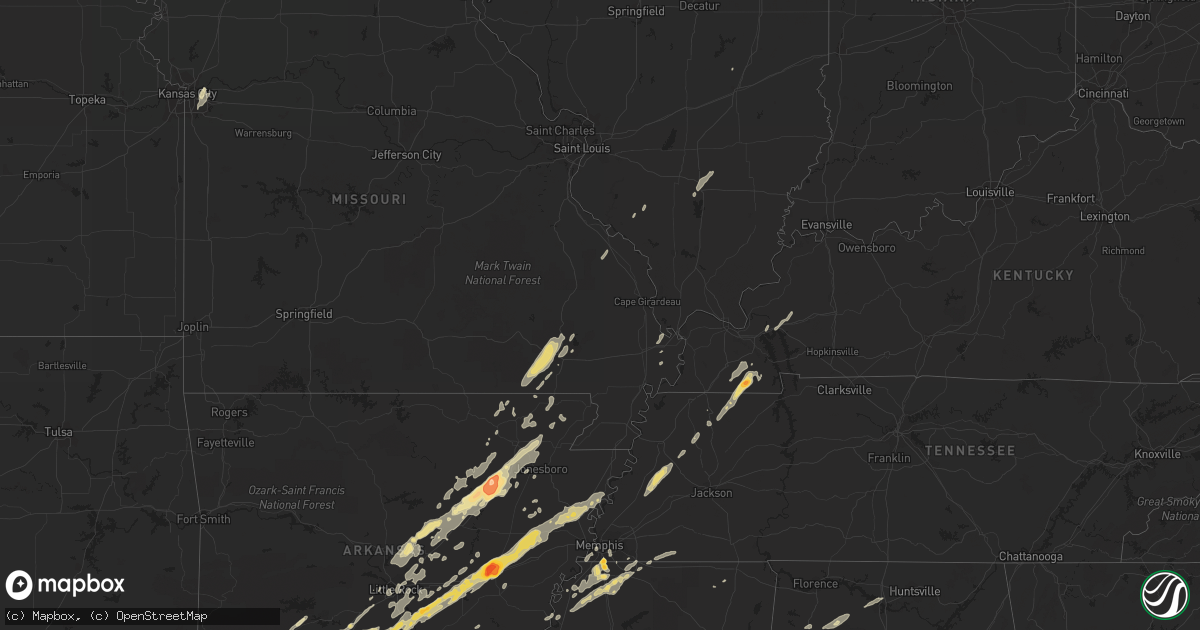
Hail Map in Kentucky on January 22, 2012
Get this storm
January 22 map
$229
one time, instant access
Download today. No call, no setup
Keep the $229
Bought the map and want the full workflow? Apply the entire $229 to a subscription within 7 days. None of it is wasted.
Every map, not just this one
This buys you this map. Subscription and you get every map we run, in the markets you choose from a few cities to whole states to nationwide. Plus real-time alerts the moment a storm fires.
Contact data
Name, contact info, occupancy, even credit band for addresses in the footprint. You go from where it hit to who to call.
Become the source they trust
Unlimited branding weather history reports on demand. You already have the documented answer ready for the property owner, and you are the one who showed up with it.
Property data and RoofTrace estimates
Pull up any address you have got, its value and the exact code rules for that jurisdiction, straight from One Click Code. Then RoofTrace estimates the squares, pitch, and roof value, priced the way you price.
Storm reports in Kentucky
Kentucky
| Date | Description |
|---|---|
| 01/22/20123:00 AM CST | Casey county department of highways reported a few trees down throughout the county. |
| 01/22/20122:50 AM CST | A few trees down on cross pike near parksville. |
| 01/22/20122:24 AM CST | One tree down near riley |
| 01/22/20121:42 AM CST | Scattered trees down around the county |
| 01/22/20121:25 AM CST | Vehicle damage from downed trees |
| 01/22/20121:25 AM CST | Power line down and transformer blown |
| 01/22/20121:23 AM CST | A local report indicates 59 MPH wind near 5 SSW FRANKLIN |
| 01/22/20121:23 AM CST | Power outages |
| 01/22/20121:15 AM CST | Power outages in the city |
| 01/22/20121:12 AM CST | Two trees reported down. |
| 01/22/201212:40 AM CST | Few trees reported down across county. |
| 01/22/201212:37 AM CST | Two trees were downed across roads in the county. One large tree fell across holt road 2 miles east of cloversport. The other fell just west of hardinsburg near the int |
| 01/22/201212:35 AM CST | Roof blown off a mobile home and blown into power lines which were downed. |
| 01/22/201212:19 AM CST | Tree down across hwy 69 |
| 01/22/201212:14 AM CST | Barn blown away along hwy 334 |
| 01/22/201212:14 AM CST | Storage building destroyed and roof damage to a few homes |
| 01/22/201212:05 AM CST | ...late report...mobile home received extensive damage along old state road. |
| 01/22/201212:01 AM CST | Over 1500 electrical customers without power in the communities of sebree...poole and slaughters. |
| 01/22/201212:01 AM CST | ...minor injuries to occupants...house received major damage...one or more barns destroyed. Trees down along highway 81. |
| 01/21/201211:55 PM CST | A local report indicates 63 MPH wind near 6 N HOPKINSVILLE |
| 01/21/201211:45 PM CST | 1 mobile home destroyed on the west side of highway 81 northeast of calhoun. |
| 01/21/201211:42 PM CST | 1 barn destroyed in north central mclean county less than 1 mile from the mclean-daviess county line. |
| 01/21/201211:40 PM CST | Several mobile homes destroyed and many trees blown over along a 6 to 7 mile swath across the county. One mobile home was left in the middle of brooks schoolhouse road |
| 01/21/201211:30 PM CST | A local report indicates 60 MPH wind near DAWSON SPRINGS |
| 01/21/201211:30 PM CST | 200 customers without power. |
| 01/21/201211:25 PM CST | Power outages. |
| 01/21/201211:25 PM CST | Power outages reported. |
| 01/21/201211:25 PM CST | Power outages. Utility company reports nearly 1000 customers affected in hopkins and christian counties. |
| 01/21/201211:25 PM CST | Late report...large trees down or uprooted along niles road. |
| 01/21/201211:14 PM CST | Marble size hail reported with this storm. |
| 01/21/201211:09 PM CST | Hail the size of hen eggs reported just southwest of town. |
| 01/21/201211:05 PM CST | Late report...damage along craig road. Numerous trees down...gutters pulled off of one home which had several windows blown out. Large tree fell across a truck. |
| 01/21/201211:05 PM CST | Quarter size hail reported. |
| 01/21/201210:40 PM CST | Power outages reported. Approximately 20 customers affected. |
| 01/21/201210:20 PM CST | Downed trees blocking rufuge road. |
| 01/21/20129:58 PM CST | Widespread power outages...up to 296 customers affected. |
| 01/21/20129:53 PM CST | Downed radio/tv antenna. |
All States Impacted by Hail Map on January 22, 2012
Cities Impacted by Hail Map on January 22, 2012
- Cotton Plant, AR
- Brinkley, AR
- Wheatley, AR
- Romance, AR
- Rose Bud, AR
- Searcy, AR
- Hampton, AR
- Royal, AR
- Bonnerdale, AR
- Chunky, MS
- Meridian, MS
- Collinsville, MS
- Bailey, MS
- Louann, AR
- Epes, AL
- Boligee, AL
- York, AL
- Livingston, AL
- Byhalia, MS
- Olive Branch, MS
- Lonoke, AR
- Perryville, MO
- Malvern, AR
- Winchester, AR
- Tillar, AR
- Monticello, AR
- Pickens, AR
- Poyen, AR
- Leola, AR
- Donaldson, AR
- Decatur, MS
- Camden, AR
- Smackover, AR
- Clanton, AL
- Wilmar, AR
- Fountain Hill, AR
- Joiner, AR
- Frenchmans Bayou, AR
- Tyronza, AR
- Bassett, AR
- Turrell, AR
- Earle, AR
- Gilmore, AR
- Alligator, MS
- Clarksdale, MS
- Shelby, MS
- Duncan, MS
- Bearden, AR
- Fordyce, AR
- Rosston, AR
- Chidester, AR
- Sarah, MS
- Coldwater, MS
- Kingsland, AR
- Sheridan, AR
- Redfield, AR
- Jefferson, AR
- Doniphan, MO
- Fairdealing, MO
- Grandin, MO
- Poplar Bluff, MO
- Ellsinore, MO
- Williamsville, MO
- Alexander, AR
- Benton, AR
- Grenada, MS
- Coffeeville, MS
- Tillatoba, MS
- Scobey, MS
- Sylacauga, AL
- Rockford, AL
- Weogufka, AL
- Benton, KY
- Hardin, KY
- Collierville, TN
- Magnolia, AR
- Traskwood, AR
- Bryant, AR
- Tunica, MS
- Imboden, AR
- Black Rock, AR
- Weiner, AR
- Little Rock, AR
- Pine Bluff, AR
- Ward, AR
- Drew, MS
- Tutwiler, MS
- Lyon, MS
- Gunnison, MS
- Vance, MS
- Lambert, MS
- Mound Bayou, MS
- Horn Lake, MS
- Lake Cormorant, MS
- Nesbit, MS
- Spruce Pine, AL
- Phil Campbell, AL
- Star City, AR
- Rison, AR
- Grady, AR
- Yorktown, AR
- Mayfield, KY
- Sedalia, KY
- Farmington, KY
- Kirksey, KY
- Trinity, AL
- Decatur, AL
- Tanner, AL
- Centreville, AL
- Maplesville, AL
- Thorsby, AL
- Randolph, AL
- Marion, AL
- Lawley, AL
- Des Arc, AR
- England, AR
- Wynne, AR
- Colt, AR
- Palestine, AR
- Humnoke, AR
- Biscoe, AR
- De Valls Bluff, AR
- Carlisle, AR
- Tucker, AR
- Stuttgart, AR
- Hazen, AR
- El Dorado, AR
- Vilonia, AR
- Conway, AR
- Mount Vernon, AR
- El Paso, AR
- Murray, KY
- Hazel, KY
- Gould, AR
- Altheimer, AR
- Waldo, AR
- Thornton, AR
- Ivan, AR
- Independence, MO
- Hermitage, AR
- Moulton, AL
- Southaven, MS
- Memphis, TN
- Dermott, AR
- Hamburg, AR
- Crossett, AR
- Strong, AR
- Jersey, AR
- Montrose, AR
- Garland City, AR
- Lewisville, AR
- Newport, AR
- Tuckerman, AR
- Hope, AR
- Emmet, AR
- Prescott, AR
- Rochester, IN
- Macy, IN
- Mount Hope, AL
- Dresden, TN
- Palmersville, TN
- Pocahontas, AR
- Scott, AR
- Beech Grove, AR
- Pleasant Plains, AR
- Alicia, AR
- Bono, AR
- Bradford, AR
- Swifton, AR
- Walnut Ridge, AR
- Cash, AR
- Judsonia, AR
- Thida, AR
- Oil Trough, AR
- Bald Knob, AR
- Philadelphia, MS
- De Kalb, MS
- Union, MS
- Hernando, MS
- Banks, AR
- Harrell, AR
- Halls, TN
- Gates, TN
- Brownsville, TN
- Ripley, TN
- Hodges, AL
- Senatobia, MS
- Dundee, MS
- Princeton, KY
- Fredonia, KY
- Kuttawa, KY
- Eddyville, KY
- Tuscaloosa, AL
- Adger, AL
- Brookwood, AL
- Northport, AL
- Arkadelphia, AR
- Prattsville, AR
- Walls, MS
- Robinsonville, MS
- Oxly, MO
- Waltonville, IL
- Corning, AR
- Wayland, MI
- Success, AR
- Gillett, AR
- Cuba, AL
- Lauderdale, MS
- Almyra, AR
- Logansport, IN
- Twelve Mile, IN
- Moro, AR
- Gurdon, AR
- Okolona, AR
- Coker, AL
- Charleston, MO
- Rosie, AR
- Sulphur Rock, AR
- Batesville, AR
- Ripley, MS
- Almo, KY
- Henning, TN
- Friendship, TN
- Tremont, MS
- Helena, AR
- Carrollton, AL
- Reform, AL
- Gordo, AL
- Cabot, AR
- North Little Rock, AR
- Jacksonville, AR
- Sherwood, AR
- Little Rock Air Force Base, AR
- Bellefontaine, MS
- Eupora, MS
- Cottage Grove, TN
- Letona, AR
- Pangburn, AR
- McRae, AR
- Harrisburg, AR
- Russellville, AL
- Town Creek, AL
- Puryear, TN
- Marion, MS
- Little Rock, MS
- Hickory, MS
- Floral, AR
- East Prairie, MO
- Alamo, TN
- Covington, TN
- Parkin, AR
- Fulton, MS
- Nettleton, MS
- Porterville, MS
- Bessemer, AL
- Oakman, AL
- Stewardson, IL
- Smithville, AR
- Mount Vernon, IL
- Rector, AR
- Lafe, AR
- Sawyerville, AL
- Forkland, AL
- Toomsuba, MS
- Peach Orchard, AR
- Delaplaine, AR
- Biggers, AR
- Charleston, MS
- Oakland, MS
- Kansas City, MO
- Kirby, AR
- Amity, AR
- Springville, AL
- Austin, AR
- Jonesboro, AR
- Bluff City, AR
- Mabelvale, AR
- Hensley, AR
- Vina, AL
- Amory, MS
- Hackleburg, AL
- Hamilton, AL
- Sharon, TN
- Rutherford, TN
- Dyer, TN
- Marked Tree, AR
- Goodwin, AR
- Cherry Valley, AR
- Wilson, AR
- Forrest City, AR
- Fisher, AR
- Corinth, MS
- Rienzi, MS
- Griffithville, AR
- Amagon, AR
- Merigold, MS
- Lees Summit, MO
- Bluford, IL
- Stamps, AR
- Taylor, AR
- De Witt, AR
- Warren, AR
- Trenton, TN
- Beebe, AR
- Heber Springs, AR
- Newark, AR
- Paragould, AR
- Greensboro, AL
- Brent, AL
- Newbern, AL
- Jemison, AL
- Ravenden Springs, AR
- Grand Junction, TN
- Moscow, TN
- Higginson, AR
- Watson, AR
- Steeleville, IL
- Sparta, IL
- Nashville, AR
- Moundville, AL
- Augusta, AR
- Cascilla, MS
- Pinson, AL
- Osceola, AR
- Clarendon, AR
- White Hall, AR
- Dyess, AR
- Gainesville, AL
- Fouke, AR
- Texarkana, AR
- New Edinburg, AR
- Buckner, AR
- Willisville, AR
- Waynesboro, MS
- Cord, AR
- Strawberry, AR
- Charlotte, AR
- Saffell, AR
- Harviell, MO
- Naylor, MO
- Crumrod, AR
- Fosters, AL
- Martin, TN
- Wappapello, MO
- Greenville, MO
- Holly Springs, MS
- Rossville, TN
- Glenwood, AR
- Ethel, AR
- Cutler, IL
- Coulterville, IL
- Gardendale, AL


