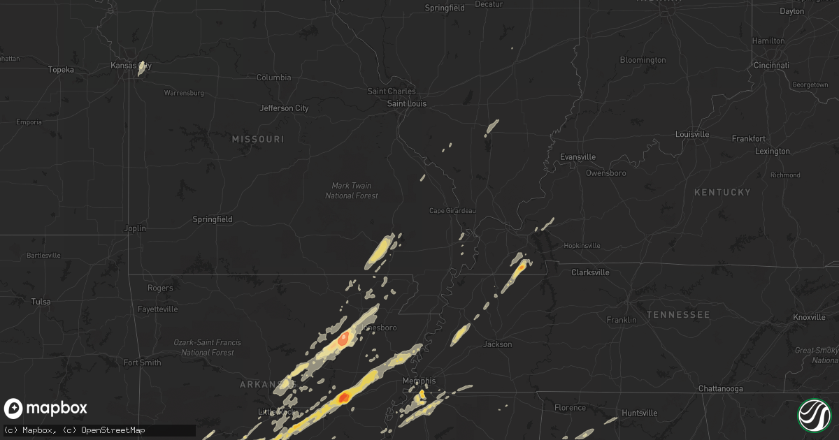
Hail Map in Mississippi on January 22, 2012
Get this storm
January 22 map
$229
one time, instant access
Download today. No call, no setup
Keep the $229
Bought the map and want the full workflow? Apply the entire $229 to a subscription within 7 days. None of it is wasted.
Every map, not just this one
This buys you this map. Subscription and you get every map we run, in the markets you choose from a few cities to whole states to nationwide. Plus real-time alerts the moment a storm fires.
Contact data
Name, contact info, occupancy, even credit band for addresses in the footprint. You go from where it hit to who to call.
Become the source they trust
Unlimited branding weather history reports on demand. You already have the documented answer ready for the property owner, and you are the one who showed up with it.
Property data and RoofTrace estimates
Pull up any address you have got, its value and the exact code rules for that jurisdiction, straight from One Click Code. Then RoofTrace estimates the squares, pitch, and roof value, priced the way you price.
Storm reports in Mississippi
Mississippi
| Date | Description |
|---|---|
| 01/22/20123:25 AM CST | Few trees down |
| 01/22/20122:53 AM CST | Lauderdale county ema reports they have received numerous public reports of a tornado on the ground in ne lauderdale county between the lockhart and lauderdale communit |
| 01/22/20122:45 AM CST | Mobile home damaged and trees and powerlines down on sam lackey road. Update from emergency manager...a few trees were snapped and uprooted and there was shingle damage |
| 01/22/20122:35 AM CST | In the bailey community |
| 01/22/20122:30 AM CST | Several pine trees blown over |
| 01/22/20121:25 AM CST | Tree down on house on pegg street and another tree down near gore springs community |
| 01/22/20121:22 AM CST | Trees and powerlines down |
| 01/22/20121:15 AM CST | Awning blown off gas station near union |
| 01/22/20121:15 AM CST | Awning blown off gas station near union |
| 01/22/20121:03 AM CST | Couple of trees down near morton |
| 01/21/201211:55 PM CST | In the elizabeth community...mobile home with some damage...trees and powerlines down...carport blown away |
| 01/21/201211:20 PM CST | Trained spotter reported tornado on the ground near trebloc. |
| 01/21/201211:00 PM CST | About 7 homes damaged from shingles being torn off...uplift of small portion of roofing material...garage door blown out and numerous windows broken. The tornado first |
| 01/21/201211:00 PM CST | Heavy damage to a home garage...4 to 5 homes on the same street damaged. Metal roof and columns torn off of one home. Power lines and power poles down. |
| 01/21/201210:41 PM CST | Trees down 6 miles south of byhalia. |
| 01/21/201210:37 PM CST | Quarter to golf ball sized hail...likely driven by wind...broke some windows |
| 01/21/201210:35 PM CST | Updated info...11 mobile homes were damaged or destroyed...numerous powerlines down...possible tornado |
| 01/21/201210:35 PM CST | Large limbs down...fence blown apart...some shingle damage to houses...numerous trees down in area including on magnolia hill |
| 01/21/201210:34 PM CST | *** 1 inj *** nws storm survey determines an ef-2 tornado with max est winds of 120 mph caused substantial damage in extreme ne bolivar county. Path length 3.75 mi...ma |
| 01/21/201210:30 PM CST | Large limbs down...fence blown apart...some shingle damage to houses |
| 01/21/201210:30 PM CST | Report of hail up to the size of golfballs on church road between getwell and pleasant hill road. |
| 01/21/201210:23 PM CST | A local report indicates 1.00 inch wind near 7 S HERNANDO |
| 01/21/201210:18 PM CST | Debris on roadway on i-55 at mile marker 275...and northbound church road exit sign on i-55 blown down. |
| 01/21/201210:05 PM CST | Power lines down near robinsonville |
| 01/21/201210:00 PM CST | 3 grain elevator bins and farm shop heavily damaged on new africa road northeast of town of alligator. |
| 01/21/20129:55 PM CST | Trailer home moved off slab foundation on bellvue road hwy 322 just outside clarksdale city limits. |
All States Impacted by Hail Map on January 22, 2012
Cities Impacted by Hail Map on January 22, 2012
- Cotton Plant, AR
- Brinkley, AR
- Wheatley, AR
- Romance, AR
- Rose Bud, AR
- Searcy, AR
- Hampton, AR
- Royal, AR
- Bonnerdale, AR
- Chunky, MS
- Meridian, MS
- Collinsville, MS
- Bailey, MS
- Louann, AR
- Epes, AL
- Boligee, AL
- York, AL
- Livingston, AL
- Byhalia, MS
- Olive Branch, MS
- Lonoke, AR
- Perryville, MO
- Malvern, AR
- Winchester, AR
- Tillar, AR
- Monticello, AR
- Pickens, AR
- Poyen, AR
- Leola, AR
- Donaldson, AR
- Decatur, MS
- Camden, AR
- Smackover, AR
- Clanton, AL
- Wilmar, AR
- Fountain Hill, AR
- Joiner, AR
- Frenchmans Bayou, AR
- Tyronza, AR
- Bassett, AR
- Turrell, AR
- Earle, AR
- Gilmore, AR
- Alligator, MS
- Clarksdale, MS
- Shelby, MS
- Duncan, MS
- Bearden, AR
- Fordyce, AR
- Rosston, AR
- Chidester, AR
- Sarah, MS
- Coldwater, MS
- Kingsland, AR
- Sheridan, AR
- Redfield, AR
- Jefferson, AR
- Doniphan, MO
- Fairdealing, MO
- Grandin, MO
- Poplar Bluff, MO
- Ellsinore, MO
- Williamsville, MO
- Alexander, AR
- Benton, AR
- Grenada, MS
- Coffeeville, MS
- Tillatoba, MS
- Scobey, MS
- Sylacauga, AL
- Rockford, AL
- Weogufka, AL
- Benton, KY
- Hardin, KY
- Collierville, TN
- Magnolia, AR
- Traskwood, AR
- Bryant, AR
- Tunica, MS
- Imboden, AR
- Black Rock, AR
- Weiner, AR
- Little Rock, AR
- Pine Bluff, AR
- Ward, AR
- Drew, MS
- Tutwiler, MS
- Lyon, MS
- Gunnison, MS
- Vance, MS
- Lambert, MS
- Mound Bayou, MS
- Horn Lake, MS
- Lake Cormorant, MS
- Nesbit, MS
- Spruce Pine, AL
- Phil Campbell, AL
- Star City, AR
- Rison, AR
- Grady, AR
- Yorktown, AR
- Mayfield, KY
- Sedalia, KY
- Farmington, KY
- Kirksey, KY
- Trinity, AL
- Decatur, AL
- Tanner, AL
- Centreville, AL
- Maplesville, AL
- Thorsby, AL
- Randolph, AL
- Marion, AL
- Lawley, AL
- Des Arc, AR
- England, AR
- Wynne, AR
- Colt, AR
- Palestine, AR
- Humnoke, AR
- Biscoe, AR
- De Valls Bluff, AR
- Carlisle, AR
- Tucker, AR
- Stuttgart, AR
- Hazen, AR
- El Dorado, AR
- Vilonia, AR
- Conway, AR
- Mount Vernon, AR
- El Paso, AR
- Murray, KY
- Hazel, KY
- Gould, AR
- Altheimer, AR
- Waldo, AR
- Thornton, AR
- Ivan, AR
- Independence, MO
- Hermitage, AR
- Moulton, AL
- Southaven, MS
- Memphis, TN
- Dermott, AR
- Hamburg, AR
- Crossett, AR
- Strong, AR
- Jersey, AR
- Montrose, AR
- Garland City, AR
- Lewisville, AR
- Newport, AR
- Tuckerman, AR
- Hope, AR
- Emmet, AR
- Prescott, AR
- Rochester, IN
- Macy, IN
- Mount Hope, AL
- Dresden, TN
- Palmersville, TN
- Pocahontas, AR
- Scott, AR
- Beech Grove, AR
- Pleasant Plains, AR
- Alicia, AR
- Bono, AR
- Bradford, AR
- Swifton, AR
- Walnut Ridge, AR
- Cash, AR
- Judsonia, AR
- Thida, AR
- Oil Trough, AR
- Bald Knob, AR
- Philadelphia, MS
- De Kalb, MS
- Union, MS
- Hernando, MS
- Banks, AR
- Harrell, AR
- Halls, TN
- Gates, TN
- Brownsville, TN
- Ripley, TN
- Hodges, AL
- Senatobia, MS
- Dundee, MS
- Princeton, KY
- Fredonia, KY
- Kuttawa, KY
- Eddyville, KY
- Tuscaloosa, AL
- Adger, AL
- Brookwood, AL
- Northport, AL
- Arkadelphia, AR
- Prattsville, AR
- Walls, MS
- Robinsonville, MS
- Oxly, MO
- Waltonville, IL
- Corning, AR
- Wayland, MI
- Success, AR
- Gillett, AR
- Cuba, AL
- Lauderdale, MS
- Almyra, AR
- Logansport, IN
- Twelve Mile, IN
- Moro, AR
- Gurdon, AR
- Okolona, AR
- Coker, AL
- Charleston, MO
- Rosie, AR
- Sulphur Rock, AR
- Batesville, AR
- Ripley, MS
- Almo, KY
- Henning, TN
- Friendship, TN
- Tremont, MS
- Helena, AR
- Carrollton, AL
- Reform, AL
- Gordo, AL
- Cabot, AR
- North Little Rock, AR
- Jacksonville, AR
- Sherwood, AR
- Little Rock Air Force Base, AR
- Bellefontaine, MS
- Eupora, MS
- Cottage Grove, TN
- Letona, AR
- Pangburn, AR
- McRae, AR
- Harrisburg, AR
- Russellville, AL
- Town Creek, AL
- Puryear, TN
- Marion, MS
- Little Rock, MS
- Hickory, MS
- Floral, AR
- East Prairie, MO
- Alamo, TN
- Covington, TN
- Parkin, AR
- Fulton, MS
- Nettleton, MS
- Porterville, MS
- Bessemer, AL
- Oakman, AL
- Stewardson, IL
- Smithville, AR
- Mount Vernon, IL
- Rector, AR
- Lafe, AR
- Sawyerville, AL
- Forkland, AL
- Toomsuba, MS
- Peach Orchard, AR
- Delaplaine, AR
- Biggers, AR
- Charleston, MS
- Oakland, MS
- Kansas City, MO
- Kirby, AR
- Amity, AR
- Springville, AL
- Austin, AR
- Jonesboro, AR
- Bluff City, AR
- Mabelvale, AR
- Hensley, AR
- Vina, AL
- Amory, MS
- Hackleburg, AL
- Hamilton, AL
- Sharon, TN
- Rutherford, TN
- Dyer, TN
- Marked Tree, AR
- Goodwin, AR
- Cherry Valley, AR
- Wilson, AR
- Forrest City, AR
- Fisher, AR
- Corinth, MS
- Rienzi, MS
- Griffithville, AR
- Amagon, AR
- Merigold, MS
- Lees Summit, MO
- Bluford, IL
- Stamps, AR
- Taylor, AR
- De Witt, AR
- Warren, AR
- Trenton, TN
- Beebe, AR
- Heber Springs, AR
- Newark, AR
- Paragould, AR
- Greensboro, AL
- Brent, AL
- Newbern, AL
- Jemison, AL
- Ravenden Springs, AR
- Grand Junction, TN
- Moscow, TN
- Higginson, AR
- Watson, AR
- Steeleville, IL
- Sparta, IL
- Nashville, AR
- Moundville, AL
- Augusta, AR
- Cascilla, MS
- Pinson, AL
- Osceola, AR
- Clarendon, AR
- White Hall, AR
- Dyess, AR
- Gainesville, AL
- Fouke, AR
- Texarkana, AR
- New Edinburg, AR
- Buckner, AR
- Willisville, AR
- Waynesboro, MS
- Cord, AR
- Strawberry, AR
- Charlotte, AR
- Saffell, AR
- Harviell, MO
- Naylor, MO
- Crumrod, AR
- Fosters, AL
- Martin, TN
- Wappapello, MO
- Greenville, MO
- Holly Springs, MS
- Rossville, TN
- Glenwood, AR
- Ethel, AR
- Cutler, IL
- Coulterville, IL
- Gardendale, AL


