Hail Map in Illinois on January 22, 2012
Get this storm
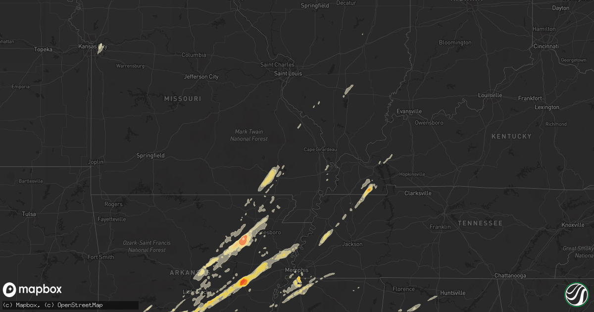
January 22 map
$229
one time, instant access
Download today. No call, no setup
Keep the $229
Bought the map and want the full workflow? Apply the entire $229 to a subscription within 7 days. None of it is wasted.
Every map, not just this one
This buys you this map. Subscription and you get every map we run, in the markets you choose from a few cities to whole states to nationwide. Plus real-time alerts the moment a storm fires.
Contact data
Name, contact info, occupancy, even credit band for addresses in the footprint. You go from where it hit to who to call.
Become the source they trust
Unlimited branding weather history reports on demand. You already have the documented answer ready for the property owner, and you are the one who showed up with it.
Property data and RoofTrace estimates
Pull up any address you have got, its value and the exact code rules for that jurisdiction, straight from One Click Code. Then RoofTrace estimates the squares, pitch, and roof value, priced the way you price.
Storm reports in Illinois
Illinois
| Date | Description |
|---|---|
| 01/21/201210:30 PM CST | Late report. |
| 01/21/201210:20 PM CST | Delayed report. Tree blown down on route 130 west of hugo blocking one lane of traffic. |
| 01/21/201210:17 PM CST | A local report indicates 58 MPH wind near HARRISBURG |
| 01/21/201210:12 PM CST | Large tree down. |
| 01/21/201210:05 PM CST | A local report indicates 60 MPH wind near ROUND KNOB |
| 01/21/201210:05 PM CST | Downed trees with standing water on roadways along dutchman lake road. |
| 01/21/20129:47 PM CST | A local report indicates 1.00 inch wind near MOUNT VERNON |
| 01/21/20129:38 PM CST | Half dollar size hail reported in the community. |
| 01/21/20129:23 PM CST | 60 mph wind gust reported on west side of town. |
| 01/21/20129:12 PM CST | 60 mph wind gust reported on west side of town. |
All States Impacted by Hail Map on January 22, 2012
Cities Impacted by Hail Map on January 22, 2012
- Cotton Plant, AR
- Brinkley, AR
- Wheatley, AR
- Romance, AR
- Rose Bud, AR
- Searcy, AR
- Hampton, AR
- Royal, AR
- Bonnerdale, AR
- Chunky, MS
- Meridian, MS
- Collinsville, MS
- Bailey, MS
- Louann, AR
- Epes, AL
- Boligee, AL
- York, AL
- Livingston, AL
- Byhalia, MS
- Olive Branch, MS
- Lonoke, AR
- Perryville, MO
- Malvern, AR
- Winchester, AR
- Tillar, AR
- Monticello, AR
- Pickens, AR
- Poyen, AR
- Leola, AR
- Donaldson, AR
- Decatur, MS
- Camden, AR
- Smackover, AR
- Clanton, AL
- Wilmar, AR
- Fountain Hill, AR
- Joiner, AR
- Frenchmans Bayou, AR
- Tyronza, AR
- Bassett, AR
- Turrell, AR
- Earle, AR
- Gilmore, AR
- Alligator, MS
- Clarksdale, MS
- Shelby, MS
- Duncan, MS
- Bearden, AR
- Fordyce, AR
- Rosston, AR
- Chidester, AR
- Sarah, MS
- Coldwater, MS
- Kingsland, AR
- Sheridan, AR
- Redfield, AR
- Jefferson, AR
- Doniphan, MO
- Fairdealing, MO
- Grandin, MO
- Poplar Bluff, MO
- Ellsinore, MO
- Williamsville, MO
- Alexander, AR
- Benton, AR
- Grenada, MS
- Coffeeville, MS
- Tillatoba, MS
- Scobey, MS
- Sylacauga, AL
- Rockford, AL
- Weogufka, AL
- Benton, KY
- Hardin, KY
- Collierville, TN
- Magnolia, AR
- Traskwood, AR
- Bryant, AR
- Tunica, MS
- Imboden, AR
- Black Rock, AR
- Weiner, AR
- Little Rock, AR
- Pine Bluff, AR
- Ward, AR
- Drew, MS
- Tutwiler, MS
- Lyon, MS
- Gunnison, MS
- Vance, MS
- Lambert, MS
- Mound Bayou, MS
- Horn Lake, MS
- Lake Cormorant, MS
- Nesbit, MS
- Spruce Pine, AL
- Phil Campbell, AL
- Star City, AR
- Rison, AR
- Grady, AR
- Yorktown, AR
- Mayfield, KY
- Sedalia, KY
- Farmington, KY
- Kirksey, KY
- Trinity, AL
- Decatur, AL
- Tanner, AL
- Centreville, AL
- Maplesville, AL
- Thorsby, AL
- Randolph, AL
- Marion, AL
- Lawley, AL
- Des Arc, AR
- England, AR
- Wynne, AR
- Colt, AR
- Palestine, AR
- Humnoke, AR
- Biscoe, AR
- De Valls Bluff, AR
- Carlisle, AR
- Tucker, AR
- Stuttgart, AR
- Hazen, AR
- El Dorado, AR
- Vilonia, AR
- Conway, AR
- Mount Vernon, AR
- El Paso, AR
- Murray, KY
- Hazel, KY
- Gould, AR
- Altheimer, AR
- Waldo, AR
- Thornton, AR
- Ivan, AR
- Independence, MO
- Hermitage, AR
- Moulton, AL
- Southaven, MS
- Memphis, TN
- Dermott, AR
- Hamburg, AR
- Crossett, AR
- Strong, AR
- Jersey, AR
- Montrose, AR
- Garland City, AR
- Lewisville, AR
- Newport, AR
- Tuckerman, AR
- Hope, AR
- Emmet, AR
- Prescott, AR
- Rochester, IN
- Macy, IN
- Mount Hope, AL
- Dresden, TN
- Palmersville, TN
- Pocahontas, AR
- Scott, AR
- Beech Grove, AR
- Pleasant Plains, AR
- Alicia, AR
- Bono, AR
- Bradford, AR
- Swifton, AR
- Walnut Ridge, AR
- Cash, AR
- Judsonia, AR
- Thida, AR
- Oil Trough, AR
- Bald Knob, AR
- Philadelphia, MS
- De Kalb, MS
- Union, MS
- Hernando, MS
- Banks, AR
- Harrell, AR
- Halls, TN
- Gates, TN
- Brownsville, TN
- Ripley, TN
- Hodges, AL
- Senatobia, MS
- Dundee, MS
- Princeton, KY
- Fredonia, KY
- Kuttawa, KY
- Eddyville, KY
- Tuscaloosa, AL
- Adger, AL
- Brookwood, AL
- Northport, AL
- Arkadelphia, AR
- Prattsville, AR
- Walls, MS
- Robinsonville, MS
- Oxly, MO
- Waltonville, IL
- Corning, AR
- Wayland, MI
- Success, AR
- Gillett, AR
- Cuba, AL
- Lauderdale, MS
- Almyra, AR
- Logansport, IN
- Twelve Mile, IN
- Moro, AR
- Gurdon, AR
- Okolona, AR
- Coker, AL
- Charleston, MO
- Rosie, AR
- Sulphur Rock, AR
- Batesville, AR
- Ripley, MS
- Almo, KY
- Henning, TN
- Friendship, TN
- Tremont, MS
- Helena, AR
- Carrollton, AL
- Reform, AL
- Gordo, AL
- Cabot, AR
- North Little Rock, AR
- Jacksonville, AR
- Sherwood, AR
- Little Rock Air Force Base, AR
- Bellefontaine, MS
- Eupora, MS
- Cottage Grove, TN
- Letona, AR
- Pangburn, AR
- McRae, AR
- Harrisburg, AR
- Russellville, AL
- Town Creek, AL
- Puryear, TN
- Marion, MS
- Little Rock, MS
- Hickory, MS
- Floral, AR
- East Prairie, MO
- Alamo, TN
- Covington, TN
- Parkin, AR
- Fulton, MS
- Nettleton, MS
- Porterville, MS
- Bessemer, AL
- Oakman, AL
- Stewardson, IL
- Smithville, AR
- Mount Vernon, IL
- Rector, AR
- Lafe, AR
- Sawyerville, AL
- Forkland, AL
- Toomsuba, MS
- Peach Orchard, AR
- Delaplaine, AR
- Biggers, AR
- Charleston, MS
- Oakland, MS
- Kansas City, MO
- Kirby, AR
- Amity, AR
- Springville, AL
- Austin, AR
- Jonesboro, AR
- Bluff City, AR
- Mabelvale, AR
- Hensley, AR
- Vina, AL
- Amory, MS
- Hackleburg, AL
- Hamilton, AL
- Sharon, TN
- Rutherford, TN
- Dyer, TN
- Marked Tree, AR
- Goodwin, AR
- Cherry Valley, AR
- Wilson, AR
- Forrest City, AR
- Fisher, AR
- Corinth, MS
- Rienzi, MS
- Griffithville, AR
- Amagon, AR
- Merigold, MS
- Lees Summit, MO
- Bluford, IL
- Stamps, AR
- Taylor, AR
- De Witt, AR
- Warren, AR
- Trenton, TN
- Beebe, AR
- Heber Springs, AR
- Newark, AR
- Paragould, AR
- Greensboro, AL
- Brent, AL
- Newbern, AL
- Jemison, AL
- Ravenden Springs, AR
- Grand Junction, TN
- Moscow, TN
- Higginson, AR
- Watson, AR
- Steeleville, IL
- Sparta, IL
- Nashville, AR
- Moundville, AL
- Augusta, AR
- Cascilla, MS
- Pinson, AL
- Osceola, AR
- Clarendon, AR
- White Hall, AR
- Dyess, AR
- Gainesville, AL
- Fouke, AR
- Texarkana, AR
- New Edinburg, AR
- Buckner, AR
- Willisville, AR
- Waynesboro, MS
- Cord, AR
- Strawberry, AR
- Charlotte, AR
- Saffell, AR
- Harviell, MO
- Naylor, MO
- Crumrod, AR
- Fosters, AL
- Martin, TN
- Wappapello, MO
- Greenville, MO
- Holly Springs, MS
- Rossville, TN
- Glenwood, AR
- Ethel, AR
- Cutler, IL
- Coulterville, IL
- Gardendale, AL


