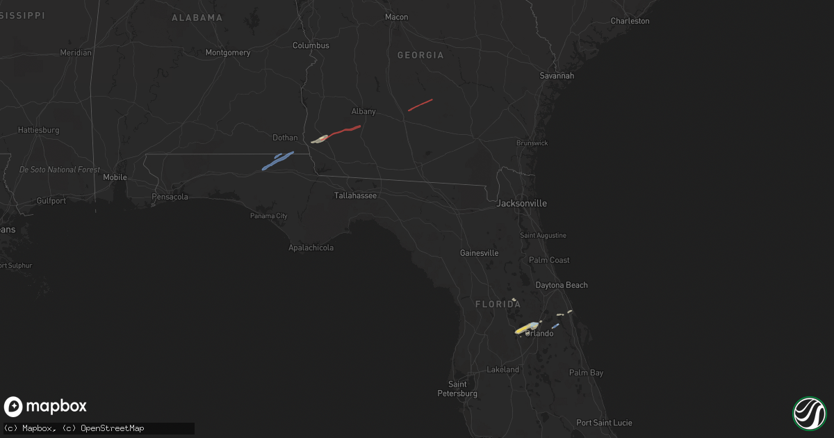
Hail Map in Florida on December 17, 2019
Get this storm
December 17 map
$229
one time, instant access
Download today. No call, no setup
Keep the $229
Bought the map and want the full workflow? Apply the entire $229 to a subscription within 7 days. None of it is wasted.
Every map, not just this one
This buys you this map. Subscription and you get every map we run, in the markets you choose from a few cities to whole states to nationwide. Plus real-time alerts the moment a storm fires.
Contact data
Name, contact info, occupancy, even credit band for addresses in the footprint. You go from where it hit to who to call.
Become the source they trust
Unlimited branding weather history reports on demand. You already have the documented answer ready for the property owner, and you are the one who showed up with it.
Property data and RoofTrace estimates
Pull up any address you have got, its value and the exact code rules for that jurisdiction, straight from One Click Code. Then RoofTrace estimates the squares, pitch, and roof value, priced the way you price.
Storm reports in Florida
Florida
| Date | Description |
|---|---|
| 12/17/20192:40 PM CST | Public reported stop signs and tree limbs down in altamonte springs near the intersection of sr 434 and 436. A sign to a business was also blown over. Time estimated ba |
| 12/17/201911:08 AM CST | Five trees and two power lines reported down scattered across calhoun county. |
| 12/17/20199:29 AM CST | Multiple trees down. One is on highway 69a between parrish lake road and john redd road. |
| 12/17/20196:08 AM CST | At 1207 PM EST/1107 AM CST/, a severe thunderstorm was located over Wewahitchka, or 22 miles north of Port St. Joe, moving east at 45 mph. HAZARD...60 mph wind gusts. SOURCE...Radar indicated. IMPACT...Expect damage to roofs, siding, and trees. Locations impacted include... Carrabelle, Eastpoint, Apalachicola, St George Island, Port St. Joe, Stonemill Creek, Orange, Franklin, Wewahitchka, Sopchoppy, Honeyville, Jewel Fire Tower, Royal Bluff, Vilas, Chipola Cutoff, St George Island St Pk, Central City, Beverly, Scotts Ferry and Poplar Camp. |
| 12/17/20195:16 AM CST | At 1115 AM EST/1015 AM CST/, a severe thunderstorm was located 12 miles west of Tyndall Air Force Base, or 12 miles southwest of Panama City, moving east at 45 mph. HAZARD...60 mph wind gusts. SOURCE...Radar indicated. IMPACT...Expect damage to roofs, siding, and trees. Locations impacted include... Panama City, Lynn Haven, Callaway, Blountstown, Port St. Joe, Springfield, Mexico Beach, Hiland Park, Stonemill Creek, Tyndall Air Force Base, Orange, Parker, Wewahitchka, Bristol, Honeyville, Jewel Fire Tower, Clarksville, Abe Springs, Allanton and Vilas. |
| 12/17/20193:58 AM CST | At 958 AM EST/858 AM CST/, a severe thunderstorm was located 17 miles west of Blountstown, moving northeast at 55 mph. HAZARD...60 mph wind gusts. SOURCE...Radar indicated. IMPACT...Expect damage to roofs, siding, and trees. Locations impacted include... Blountstown, Bristol, Altha, Rock Bluff, Clarksville, Red Oak, Ocheesee, Selman, Chason, Chipola, Henderson Mill, Kennys Mill, Willis, Nettle Ridge, Frink, Alliance, Blountstown Airport, Macedonia, Torreya State Park and Durham. |
| 12/16/20199:47 PM CST | At 347 PM EST, a severe thunderstorm was located over Altamonte Springs, moving northeast at 25 mph. HAZARD...60 mph wind gusts and penny size hail. SOURCE...Radar indicated. IMPACT...Expect damage to roofs, siding, and trees. Locations impacted include... Orlando, Sanford, Apopka, Altamonte Springs and Ocoee. |
| 12/16/20199:39 PM CST | At 339 PM EST, severe thunderstorms were located along a line extending from near Waynesville to near Race Pond to 11 miles southeast of Fargo, moving northeast at 45 mph. HAZARD...60 mph wind gusts. SOURCE...Radar indicated. IMPACT...Expect damage to roofs, siding, and trees. Locations impacted include... Folkston, Woodbine, Dock Junction, Homeland, Waverly, Thalmann, Everett, Waynesville, Atkinson and Winokur. |
| 12/16/20199:00 PM CST | At 300 PM EST, severe thunderstorms were located along a line extending from 12 miles northwest of Stephen Foster State Park to 7 miles northwest of Belmont, moving east at 45 mph. HAZARD...60 mph wind gusts. SOURCE...Radar indicated. IMPACT...Expect damage to roofs, siding, and trees. Locations impacted include... Fargo, Stephen Foster State Park and Needmore. |
| 12/16/20198:56 PM CST | At 256 PM EST, a severe thunderstorm was located near Ferndale, moving northeast at 35 mph. HAZARD...60 mph wind gusts and quarter size hail. SOURCE...Radar indicated. IMPACT...Hail damage to vehicles is expected. Expect wind damage to roofs, siding, and trees. Locations impacted include... Lake Apopka, Apopka, Altamonte Springs, Ocoee and Winter Garden. |
Cities Impacted by Hail Map on December 17, 2019
- Ocoee, FL
- Altamonte Springs, FL
- Montverde, FL
- Winter Garden, FL
- Orlando, FL
- Clermont, FL
- Apopka, FL
- Umatilla, FL
- Colquitt, GA
- Oak Hill, FL
- Oakland, FL
- Longwood, FL
- Maitland, FL
- Oviedo, FL
- Osteen, FL
- Windermere, FL
- Gotha, FL
- Blakely, GA
- Donalsonville, GA
- Jakin, GA
- Geneva, FL
- Graceville, FL
- Cottondale, FL
- Cottonwood, AL
- Bonifay, FL
- Gordon, AL
- Marianna, FL
- Campbellton, FL
- Fitzgerald, GA
- Chula, GA
- Ocilla, GA
- Newton, GA
- Camilla, GA
- Albany, GA
- Damascus, GA
- Leary, GA


