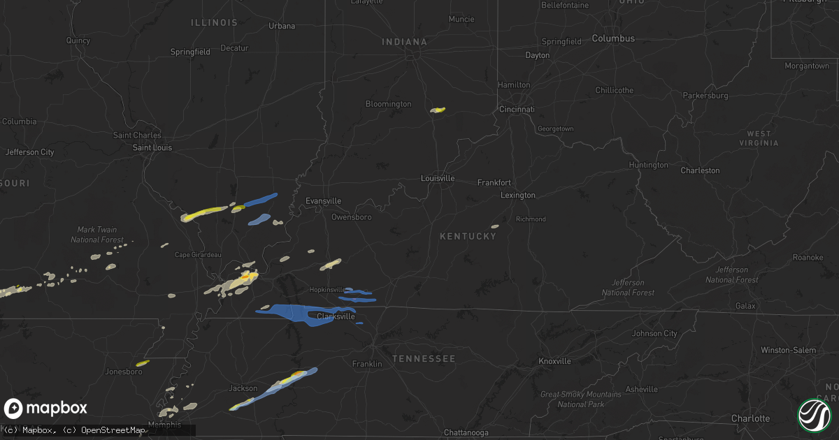
Hail Map in Kentucky on December 5, 2021
Get this storm
December 5 map
$229
one time, instant access
Download today. No call, no setup
Keep the $229
Bought the map and want the full workflow? Apply the entire $229 to a subscription within 7 days. None of it is wasted.
Every map, not just this one
This buys you this map. Subscription and you get every map we run, in the markets you choose from a few cities to whole states to nationwide. Plus real-time alerts the moment a storm fires.
Contact data
Name, contact info, occupancy, even credit band for addresses in the footprint. You go from where it hit to who to call.
Become the source they trust
Unlimited branding weather history reports on demand. You already have the documented answer ready for the property owner, and you are the one who showed up with it.
Property data and RoofTrace estimates
Pull up any address you have got, its value and the exact code rules for that jurisdiction, straight from One Click Code. Then RoofTrace estimates the squares, pitch, and roof value, priced the way you price.
Storm reports in Kentucky
Kentucky
| Date | Description |
|---|---|
| 12/05/20215:30 AM CST | Powerlines are down around scott county... Ky. Due to this... The scott county schools have been closed for today. |
| 12/05/20215:27 AM CST | Power pole and lines down on lincoln ave at red lane. Time estimated from radar. |
| 12/05/20215:25 AM CST | Few trees down on rt 784 and rt 1 near carter county line. |
| 12/05/20215:21 AM CST | Trees down on wesley rd. Area had three rounds of storms from 1 to 7 am. Estimated the last wave caused this damage. |
| 12/05/20215:00 AM CST | *** 2 inj *** 2 overturned mobile homes... Many trees and powerlines down over roads... Tree down on home... Damage to homes and mobile homes... And 2 injuries in the d |
| 12/05/20214:51 AM CST | Dispatch reported a tree across old volney rd. Time approximated from radar. |
| 12/05/20214:43 AM CST | Significant tree damage on clay cole rd. Possible tornado. |
| 12/05/20214:40 AM CST | Trees blocking old railroad lane and herman road. Possible tornado. |
| 12/05/20214:37 AM CST | Significant tree damage and structure damage to an outbuilding on highway 106. Possible tornado. |
| 12/05/20214:37 AM CST | Semi trailer storing construction equipment overturned near the intersection of highways 181 and 106. Possible tornado. |
| 12/05/20214:36 AM CST | Damage to a house on pond river road. Trees down over b white road. Possible tornado. |
| 12/05/20213:50 AM CST | Significant tree and powerline damage reported along and near highway 280 two to three miles east of murray. Possible tornado. |
| 12/05/20213:41 AM CST | Tree downed onto a house on crossland road. |
| 12/05/20213:39 AM CST | Damage to a barn. Trees and powerlines downed. Damage concentrated along cherokee trail near lynn grove. Time estimated from radar. |
| 12/05/20213:30 AM CST | Report from mping: trees uprooted or snapped; roof blown off. |
| 12/05/20213:25 AM CST | Nws storm survey found straight-lined wind damage peaking at 80 mph in an area roughly a quarter of a mile by a third of a mile. Damage was concentrated along duvall st |
| 12/05/20213:22 AM CST | *** 2 inj *** an ef1 tornado with peak winds around 95 mph briefly touched in stamping ground. It was on the ground for a quarter of a mile with a maximum width of 60 y |
| 12/05/20212:40 AM CST | At 840 PM CST, a severe thunderstorm was located near Crofton, or 11 miles east of Dawson Springs, moving east at 45 mph. HAZARD...60 mph wind gusts and penny size hail. SOURCE...Radar indicated. IMPACT...Expect damage to roofs, siding, and trees. This severe thunderstorm will be near... Weir and Graham around 900 PM CST.Other locations in the path of this severe thunderstorm includeGreenville, Central City and Powderly.This includes the following highways... Interstate 69 in Kentucky between Mile Markers 105 and 106. Western Kentucky Parkway between Mile Markers 39 and 65. Pennyrile Parkway between Mile Markers 21 and 34. |
| 12/05/202112:39 AM CST | Trees down on yates road off hwy 300. Time estimated from radar. Dispatcher also reported high water there. |
| 12/05/202112:39 AM CST | Trees down. Time estimated from radar. |
| 12/05/202112:36 AM CST | Tree down near intersection of high street and fifth street. Time estimated from radar. |
| 12/05/202112:27 AM CST | Trees down on tank pond road. Time approximated from radar. |
| 12/05/202112:05 AM CST | Tree partially blocking road at short line pike near 68e. Time estimated from radar. Also reported a tree across the road at hood lane off fairgrounds road...similar ti |
| 12/05/202112:00 AM CST | Trees and wires down across boldrick ave near woodlawn ave. Time approximated from radar. |
| 12/04/20218:31 PM CST | A captain on the ohio river near the confluence of the tennessee and ohio rivers reported a tornado narrowly missed their boat as it crossed the river. The tornado ripp |
| 12/04/20217:35 PM CST | Most hail was dimed size largest was 1.5 inches. |
All States Impacted by Hail Map on December 5, 2021
Cities Impacted by Hail Map on December 5, 2021
- Eminence, MO
- Blue Eye, MO
- Lampe, MO
- Covington, TN
- Hollister, MO
- Lake City, AR
- Monette, AR
- Fancy Farm, KY
- Arlington, KY
- Bardwell, KY
- Melber, KY
- Cunningham, KY
- Hickory, KY
- Memphis, TN
- Millington, TN
- White Plains, KY
- Graham, KY
- Nortonville, KY
- Dora, MO
- Drury, MO
- Wickliffe, KY
- Pomona, MO
- Mountain View, MO
- Branson, MO
- Shell Knob, MO
- Kimberling City, MO
- Reeds Spring, MO
- Adair, OK
- Linden, TN
- Lobelville, TN
- Marion, KY
- Squires, MO
- Ava, MO
- Paducah, KY
- Wasola, MO
- Kevil, KY
- Perryville, MO
- Ava, IL
- Murphysboro, IL
- Frohna, MO
- Rockwood, IL
- Jacob, IL
- Crofton, KY
- Greenville, KY
- Saint Charles, KY
- Scipio, IN
- Elizabethtown, IN
- Orient, IL
- West Frankfort, IL
- Johnston City, IL
- West Paducah, KY
- Columbus, KY
- East Prairie, MO
- Charleston, MO
- Anniston, MO
- Boaz, KY
- La Center, KY
- Annapolis, MO
- Farmington, KY
- Murray, KY
- Kirksey, KY
- Salem, KY
- Fredonia, KY
- Parsons, TN
- Elkville, IL
- Royalton, IL
- De Soto, IL
- Zeigler, IL
- Catoosa, OK
- Claremore, OK
- Owasso, OK
- Farrar, MO
- Vergennes, IL
- Winona, MO
- Thornfield, MO
- Tulsa, OK
- Medon, TN
- Toone, TN
- Equality, IL
- Junction, IL
- Shawneetown, IL
- Sugar Tree, TN
- Darden, TN
- Drummonds, TN
- Danville, KY
- Willow Springs, MO
- Providence, KY
- Nebo, KY
- Brookport, IL
- Benton, IL
- Dudley, MO
- Walnut Shade, MO
- Birch Tree, MO
- Metropolis, IL
- Essex, MO
- Dexter, MO
- Jenks, OK
- Sand Springs, OK
- Sapulpa, OK
- Broken Arrow, OK
- Bixby, OK
- Henning, TN
- Ellington, MO
- Theodosia, MO
- Cape Fair, MO
- Galena, MO
- Hughes, AR
- Heth, AR
- Lesterville, MO
- New Albany, MS
- Myrtle, MS
- Westport, IN
- North Vernon, IN
- Seymour, IN
- Forsyth, MO
- Kissee Mills, MO
- Bradleyville, MO
- Rueter, MO
- Wilson, AR
- Noble, MO
- Taneyville, MO
- Lexington, TN
- Redford, MO
- Kirbyville, MO
- Patton, MO
- Marble Hill, MO
- Scotts Hill, TN
- Arcadia, MO
- Proctor, AR
- Mason, TN
- Arlington, TN
- Brighton, TN
- Henderson, TN
- Pinson, TN
- Atoka, TN
- Holcomb, MO
- Piggott, AR
- Vanzant, MO
- Norwood, MO
- Luray, TN
- Only, TN
- Huron, TN
- Decaturville, TN
- Centerville, TN
- Hurricane Mills, TN
- Reagan, TN
- Jacks Creek, TN
- Beech Bluff, TN
- Tennessee Ridge, TN
- Almo, KY
- Sedalia, KY
- Adams, TN
- Indian Mound, TN
- Hazel, KY
- Clarksville, TN
- New Concord, KY
- Cadiz, KY
- Palmyra, TN
- Mayfield, KY
- Bumpus Mills, TN
- Big Rock, TN
- Cedar Hill, TN
- Buchanan, TN
- Woodlawn, TN
- Cumberland City, TN
- Dover, TN
- Springfield, TN
- Pleasant View, TN
- Greenbrier, TN
- Inola, OK
- Chouteau, OK
- Harrisburg, IL
- Eldorado, IL
- Carrier Mills, IL
- Stonefort, IL
- Norris City, IL
- Enfield, IL
- Broughton, IL
- Dale, IL
- McLeansboro, IL
- Macedonia, IL
- Thompsonville, IL
- Olmstead, KY
- Guthrie, KY
- Pembroke, KY
- Allensville, KY
- Russellville, KY
- Adairville, KY
- Elkton, KY
- Trenton, KY
- Franklin, KY
- Lewisburg, KY
- Auburn, KY
- Leachville, AR
- Potts Camp, MS
- Guntown, MS
- Hickory Flat, MS
- Dumas, MS
- Blue Springs, MS
- Ecru, MS


