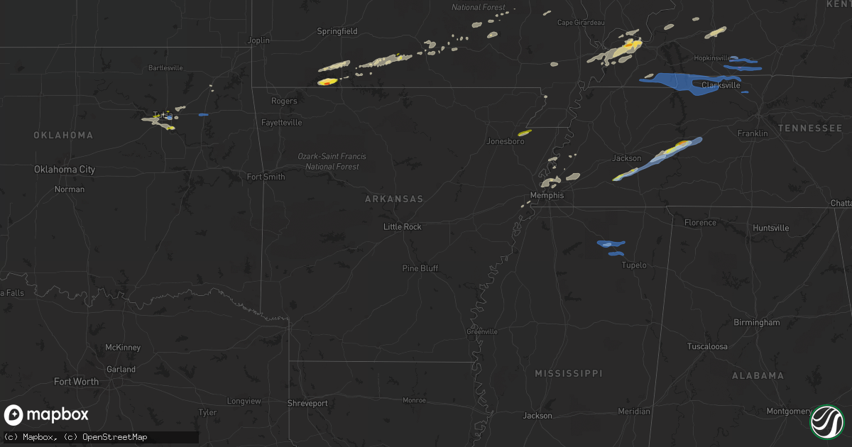
Hail Map in Arkansas on December 5, 2021
Get this storm
December 5 map
$229
one time, instant access
Download today. No call, no setup
Keep the $229
Bought the map and want the full workflow? Apply the entire $229 to a subscription within 7 days. None of it is wasted.
Every map, not just this one
This buys you this map. Subscription and you get every map we run, in the markets you choose from a few cities to whole states to nationwide. Plus real-time alerts the moment a storm fires.
Contact data
Name, contact info, occupancy, even credit band for addresses in the footprint. You go from where it hit to who to call.
Become the source they trust
Unlimited branding weather history reports on demand. You already have the documented answer ready for the property owner, and you are the one who showed up with it.
Property data and RoofTrace estimates
Pull up any address you have got, its value and the exact code rules for that jurisdiction, straight from One Click Code. Then RoofTrace estimates the squares, pitch, and roof value, priced the way you price.
Storm reports in Arkansas
Arkansas
| Date | Description |
|---|---|
| 12/05/20214:00 AM CST | At 959 PM CST, severe thunderstorms were located along a line extending from 4 miles northwest of Gravette to 4 miles west of West Siloam Springs, moving east at 50 mph. HAZARD...60 mph wind gusts and nickel size hail. SOURCE...Radar indicated. IMPACT...Expect damage to roofs, siding, and trees. Locations in or near the path include... Springdale... Rogers... Bentonville... Bella Vista... Lowell... Pea Ridge... Gentry... Bethel Heights... Gravette... Cave Springs... Decatur... Highfill... Gateway... Springtown... Northwest Arkansas Regional Air... Hiwasse... Hobbs State Park... War Eagle... Miller... Centerton...This includes Interstate 49 between mile markers 76 and 93. |
| 12/05/20213:23 AM CST | At 923 PM CST, severe thunderstorms were located along a line extending from 2 miles southwest of Hoot Owl to 6 miles southeast of Chouteau to 3 miles southwest of Oneta, moving east at 30 mph. HAZARD...60 mph wind gusts and quarter size hail. SOURCE...Radar indicated. IMPACT...Hail damage to vehicles is expected. Expect wind damage to roofs, siding, and trees. Locations in or near the path include... Broken Arrow... Siloam Springs... Wagoner... Jay... Pryor... Coweta... Pryor Creek... Chouteau... Inola... Locust Grove... Salina... West Siloam Springs... Colcord... Kansas... Hulbert... Spavinaw... Oaks... Hoot Owl... Peggs... Rose... |
| 12/04/20216:45 PM CST | Quarter sized hail north of monette near childress. |
| 12/04/20216:45 PM CST | Quarter sized hail north of monette near childress. |
All States Impacted by Hail Map on December 5, 2021
Cities Impacted by Hail Map on December 5, 2021
- Eminence, MO
- Blue Eye, MO
- Lampe, MO
- Covington, TN
- Hollister, MO
- Lake City, AR
- Monette, AR
- Fancy Farm, KY
- Arlington, KY
- Bardwell, KY
- Melber, KY
- Cunningham, KY
- Hickory, KY
- Memphis, TN
- Millington, TN
- White Plains, KY
- Graham, KY
- Nortonville, KY
- Dora, MO
- Drury, MO
- Wickliffe, KY
- Pomona, MO
- Mountain View, MO
- Branson, MO
- Shell Knob, MO
- Kimberling City, MO
- Reeds Spring, MO
- Adair, OK
- Linden, TN
- Lobelville, TN
- Marion, KY
- Squires, MO
- Ava, MO
- Paducah, KY
- Wasola, MO
- Kevil, KY
- Perryville, MO
- Ava, IL
- Murphysboro, IL
- Frohna, MO
- Rockwood, IL
- Jacob, IL
- Crofton, KY
- Greenville, KY
- Saint Charles, KY
- Scipio, IN
- Elizabethtown, IN
- Orient, IL
- West Frankfort, IL
- Johnston City, IL
- West Paducah, KY
- Columbus, KY
- East Prairie, MO
- Charleston, MO
- Anniston, MO
- Boaz, KY
- La Center, KY
- Annapolis, MO
- Farmington, KY
- Murray, KY
- Kirksey, KY
- Salem, KY
- Fredonia, KY
- Parsons, TN
- Elkville, IL
- Royalton, IL
- De Soto, IL
- Zeigler, IL
- Catoosa, OK
- Claremore, OK
- Owasso, OK
- Farrar, MO
- Vergennes, IL
- Winona, MO
- Thornfield, MO
- Tulsa, OK
- Medon, TN
- Toone, TN
- Equality, IL
- Junction, IL
- Shawneetown, IL
- Sugar Tree, TN
- Darden, TN
- Drummonds, TN
- Danville, KY
- Willow Springs, MO
- Providence, KY
- Nebo, KY
- Brookport, IL
- Benton, IL
- Dudley, MO
- Walnut Shade, MO
- Birch Tree, MO
- Metropolis, IL
- Essex, MO
- Dexter, MO
- Jenks, OK
- Sand Springs, OK
- Sapulpa, OK
- Broken Arrow, OK
- Bixby, OK
- Henning, TN
- Ellington, MO
- Theodosia, MO
- Cape Fair, MO
- Galena, MO
- Hughes, AR
- Heth, AR
- Lesterville, MO
- New Albany, MS
- Myrtle, MS
- Westport, IN
- North Vernon, IN
- Seymour, IN
- Forsyth, MO
- Kissee Mills, MO
- Bradleyville, MO
- Rueter, MO
- Wilson, AR
- Noble, MO
- Taneyville, MO
- Lexington, TN
- Redford, MO
- Kirbyville, MO
- Patton, MO
- Marble Hill, MO
- Scotts Hill, TN
- Arcadia, MO
- Proctor, AR
- Mason, TN
- Arlington, TN
- Brighton, TN
- Henderson, TN
- Pinson, TN
- Atoka, TN
- Holcomb, MO
- Piggott, AR
- Vanzant, MO
- Norwood, MO
- Luray, TN
- Only, TN
- Huron, TN
- Decaturville, TN
- Centerville, TN
- Hurricane Mills, TN
- Reagan, TN
- Jacks Creek, TN
- Beech Bluff, TN
- Tennessee Ridge, TN
- Almo, KY
- Sedalia, KY
- Adams, TN
- Indian Mound, TN
- Hazel, KY
- Clarksville, TN
- New Concord, KY
- Cadiz, KY
- Palmyra, TN
- Mayfield, KY
- Bumpus Mills, TN
- Big Rock, TN
- Cedar Hill, TN
- Buchanan, TN
- Woodlawn, TN
- Cumberland City, TN
- Dover, TN
- Springfield, TN
- Pleasant View, TN
- Greenbrier, TN
- Inola, OK
- Chouteau, OK
- Harrisburg, IL
- Eldorado, IL
- Carrier Mills, IL
- Stonefort, IL
- Norris City, IL
- Enfield, IL
- Broughton, IL
- Dale, IL
- McLeansboro, IL
- Macedonia, IL
- Thompsonville, IL
- Olmstead, KY
- Guthrie, KY
- Pembroke, KY
- Allensville, KY
- Russellville, KY
- Adairville, KY
- Elkton, KY
- Trenton, KY
- Franklin, KY
- Lewisburg, KY
- Auburn, KY
- Leachville, AR
- Potts Camp, MS
- Guntown, MS
- Hickory Flat, MS
- Dumas, MS
- Blue Springs, MS
- Ecru, MS


