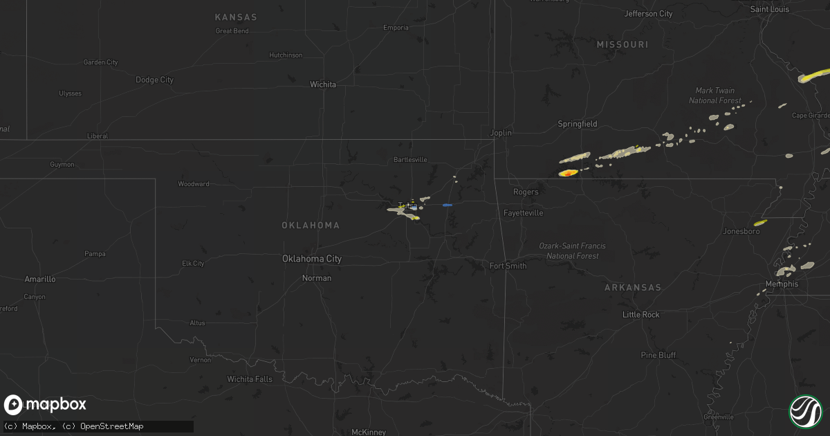
Hail Map on December 5, 2021
Get this storm
December 5 map
$229
one time, instant access
Download today. No call, no setup
Keep the $229
Bought the map and want the full workflow? Apply the entire $229 to a subscription within 7 days. None of it is wasted.
Every map, not just this one
This buys you this map. Subscription and you get every map we run, in the markets you choose from a few cities to whole states to nationwide. Plus real-time alerts the moment a storm fires.
Contact data
Name, contact info, occupancy, even credit band for addresses in the footprint. You go from where it hit to who to call.
Become the source they trust
Unlimited branding weather history reports on demand. You already have the documented answer ready for the property owner, and you are the one who showed up with it.
Property data and RoofTrace estimates
Pull up any address you have got, its value and the exact code rules for that jurisdiction, straight from One Click Code. Then RoofTrace estimates the squares, pitch, and roof value, priced the way you price.
States Impacted by Hail Map on December 5, 2021
Storm reports
Missouri
| Date | Description |
|---|---|
| 12/05/20214:00 AM CST | At 1000 PM CST, a severe thunderstorm was located 7 miles west of Altenburg, or 10 miles southeast of Perryville, moving east at 55 mph. HAZARD...60 mph wind gusts and penny size hail. SOURCE...Radar indicated. IMPACT...Expect damage to roofs, siding, and trees. This severe thunderstorm will be near... Altenburg around 1010 PM CST. Grand Tower around 1015 PM CST.Other locations in the path of this severe thunderstorm includeMurphysboro and Cedar Lake Area.This includes Interstate 55 between Mile Markers 115 and 123. |
| 12/05/20213:57 AM CST | At 956 PM CST, severe thunderstorms were located along a line extending from near Buckhorn to near Garwood, moving east at 40 mph. HAZARD...60 mph wind gusts and penny size hail. SOURCE...Radar indicated. IMPACT...Expect damage to roofs, siding, and trees. Severe thunderstorms will be near... Cascade around 1005 PM CST.Other locations in the path of these severe thunderstorms includeGreenville and Shook. |
| 12/05/20213:50 AM CST | At 949 PM CST, a severe thunderstorm was located 7 miles south of Kimberling City, moving east at 45 mph. HAZARD...60 mph wind gusts and quarter size hail. SOURCE...Radar indicated. IMPACT...Hail damage to vehicles is expected. Expect wind damage to roofs, siding, and trees. Locations impacted include... Branson... Table Rock Lake... Lake Taneycomo... Bull Shoals Lake... Table Rock State Park... Hollister... Forsyth... Kissee Mills... Indian Point... Table Rock... Kirbyville... Blue Eye... Coney Island... Powersite... Protem... Lampe... Rueter... Ridgedale... Ozark Beach... Edgewater Beach... |
| 12/05/20213:03 AM CST | At 903 PM CST, a severe thunderstorm was located 11 miles south of Ava, moving east at 35 mph. HAZARD...60 mph wind gusts and quarter size hail. SOURCE...Radar indicated. IMPACT...Hail damage to vehicles is expected. Expect wind damage to roofs, siding, and trees. Locations impacted include... Wasola... Brixey... Noble... Squires... Dora... Rockbridge... Drury... Gentryville... |
| 12/05/20212:57 AM CST | At 855 PM CST, a severe thunderstorm was located over Reeds Spring, or near Kimberling City, moving east at 35 mph. HAZARD...60 mph wind gusts and quarter size hail. SOURCE...Radar indicated. IMPACT...Hail damage to vehicles is expected. Expect wind damage to roofs, siding, and trees. Locations impacted include... Table Rock Lake... Reeds Spring... Branson West... |
| 12/05/20212:48 AM CST | At 847 PM CST, a severe thunderstorm was located near Merriam Woods, or 7 miles northwest of Forsyth, moving east at 40 mph. HAZARD...60 mph wind gusts and quarter size hail. SOURCE...Radar indicated. IMPACT...Hail damage to vehicles is expected. Expect wind damage to roofs, siding, and trees. Locations impacted include... Taneyville... Goodhope... Garrison... Rome... Brownbranch... Bradleyville... |
| 12/04/202110:14 PM CST | A local report indicates 1.25 inch wind near TABLE ROCK |
| 12/04/202110:10 PM CST | A local report indicates 1.25 inch wind near 4 N BLUE EYE |
| 12/04/202110:06 PM CST | A local report indicates 1.25 inch wind near 1 ESE TABLE ROCK |
| 12/04/202110:03 PM CST | A local report indicates 1.00 inch wind near TABLE ROCK |
| 12/04/202110:02 PM CST | A nws survey confirmed that an ef-1 tornado touched down northeast of highlandville and caused extensive damage to the roof of an outbuilding. The tornado continued eas |
| 12/04/20219:57 PM CST | A local report indicates 1.75 inch wind near 4 N BLUE EYE |
| 12/04/20219:48 PM CST | A local report indicates 1.00 inch wind near DRURY |
Oklahoma
| Date | Description |
|---|---|
| 12/05/20212:40 AM CST | At 840 PM CST, severe thunderstorms were located along a line extending from 2 miles west of Catoosa to Sapulpa, moving east at 45 mph. HAZARD...60 mph wind gusts and quarter size hail. SOURCE...Radar indicated. IMPACT...Hail damage to vehicles is expected. Expect wind damage to roofs, siding, and trees. Locations in or near the path include... Tulsa... Broken Arrow... Wagoner... Bixby... Jenks... Glenpool... Coweta... Catoosa... Verdigris... Chouteau... Inola... Locust Grove... Rose... Jenks Riverside Airport... Sportsmen Acres Community... Oneta... Leach... Mazie... Murphy... This includes Interstate 44 between mile markers 221 and 243. |
| 12/04/20219:11 PM CST | Dime to quarter size hail. |
| 12/04/20219:10 PM CST | A local report indicates 1.00 inch wind near BIXBY |
| 12/04/20219:05 PM CST | Time estimated from radar. |
| 12/04/20218:56 PM CST | Strong thunderstorm wind snapped large tree limbs. |
| 12/04/20218:40 PM CST | A local report indicates 1.00 inch wind near 5 NNE TULSA |
| 12/04/20218:25 PM CST | Quarter size hail near us 412 and 49th w ave. |
| 12/04/20218:19 PM CST | A local report indicates 60 MPH wind near 4 WNW TULSA |
Kentucky
| Date | Description |
|---|---|
| 12/05/20215:30 AM CST | Powerlines are down around scott county... Ky. Due to this... The scott county schools have been closed for today. |
| 12/05/20215:27 AM CST | Power pole and lines down on lincoln ave at red lane. Time estimated from radar. |
| 12/05/20215:25 AM CST | Few trees down on rt 784 and rt 1 near carter county line. |
| 12/05/20215:21 AM CST | Trees down on wesley rd. Area had three rounds of storms from 1 to 7 am. Estimated the last wave caused this damage. |
| 12/05/20215:00 AM CST | *** 2 inj *** 2 overturned mobile homes... Many trees and powerlines down over roads... Tree down on home... Damage to homes and mobile homes... And 2 injuries in the d |
| 12/05/20214:51 AM CST | Dispatch reported a tree across old volney rd. Time approximated from radar. |
| 12/05/20214:43 AM CST | Significant tree damage on clay cole rd. Possible tornado. |
| 12/05/20214:40 AM CST | Trees blocking old railroad lane and herman road. Possible tornado. |
| 12/05/20214:37 AM CST | Significant tree damage and structure damage to an outbuilding on highway 106. Possible tornado. |
| 12/05/20214:37 AM CST | Semi trailer storing construction equipment overturned near the intersection of highways 181 and 106. Possible tornado. |
| 12/05/20214:36 AM CST | Damage to a house on pond river road. Trees down over b white road. Possible tornado. |
| 12/05/20213:50 AM CST | Significant tree and powerline damage reported along and near highway 280 two to three miles east of murray. Possible tornado. |
| 12/05/20213:41 AM CST | Tree downed onto a house on crossland road. |
| 12/05/20213:39 AM CST | Damage to a barn. Trees and powerlines downed. Damage concentrated along cherokee trail near lynn grove. Time estimated from radar. |
| 12/05/20213:30 AM CST | Report from mping: trees uprooted or snapped; roof blown off. |
| 12/05/20213:25 AM CST | Nws storm survey found straight-lined wind damage peaking at 80 mph in an area roughly a quarter of a mile by a third of a mile. Damage was concentrated along duvall st |
| 12/05/20213:22 AM CST | *** 2 inj *** an ef1 tornado with peak winds around 95 mph briefly touched in stamping ground. It was on the ground for a quarter of a mile with a maximum width of 60 y |
| 12/05/20212:40 AM CST | At 840 PM CST, a severe thunderstorm was located near Crofton, or 11 miles east of Dawson Springs, moving east at 45 mph. HAZARD...60 mph wind gusts and penny size hail. SOURCE...Radar indicated. IMPACT...Expect damage to roofs, siding, and trees. This severe thunderstorm will be near... Weir and Graham around 900 PM CST.Other locations in the path of this severe thunderstorm includeGreenville, Central City and Powderly.This includes the following highways... Interstate 69 in Kentucky between Mile Markers 105 and 106. Western Kentucky Parkway between Mile Markers 39 and 65. Pennyrile Parkway between Mile Markers 21 and 34. |
| 12/05/202112:39 AM CST | Trees down. Time estimated from radar. |
| 12/05/202112:39 AM CST | Trees down on yates road off hwy 300. Time estimated from radar. Dispatcher also reported high water there. |
| 12/05/202112:36 AM CST | Tree down near intersection of high street and fifth street. Time estimated from radar. |
| 12/05/202112:27 AM CST | Trees down on tank pond road. Time approximated from radar. |
| 12/05/202112:05 AM CST | Tree partially blocking road at short line pike near 68e. Time estimated from radar. Also reported a tree across the road at hood lane off fairgrounds road...similar ti |
| 12/05/202112:00 AM CST | Trees and wires down across boldrick ave near woodlawn ave. Time approximated from radar. |
| 12/04/20218:31 PM CST | A captain on the ohio river near the confluence of the tennessee and ohio rivers reported a tornado narrowly missed their boat as it crossed the river. The tornado ripp |
| 12/04/20217:35 PM CST | Most hail was dimed size largest was 1.5 inches. |
Illinois
| Date | Description |
|---|---|
| 12/05/20214:50 AM CST | At 1049 PM CST, severe thunderstorms were located along a line extending from Johnston City to near Lake Of Egypt Area to near Anna, moving east at 55 mph. HAZARD...60 mph wind gusts. SOURCE...Radar indicated. IMPACT...Expect damage to roofs, siding, and trees. Severe thunderstorms will be near... Marion, Johnston City, Pittsburg, Creal Springs and Lake Of Egypt Area around 1055 PM CST. Goreville around 1105 PM CST.Other locations in the path of these severe thunderstorms includeVienna, Galatia, Carrier Mills, Harrisburg and Eldorado.This includes the following highways... Interstate 24 in Illinois between Mile Markers 1 and 16. Interstate 57 in Illinois between Mile Markers 27 and 60. |
| 12/05/20213:59 AM CST | At 959 PM CST, a severe thunderstorm was located near Murphysboro, moving east at 45 mph. HAZARD...60 mph wind gusts and quarter size hail. SOURCE...Radar indicated. IMPACT...Hail damage to vehicles is expected. Expect wind damage to roofs, siding, and trees. This severe thunderstorm will be near... De Soto around 1005 PM CST. Elkville around 1010 PM CST. Cambria, Royalton and Hurst around 1015 PM CST.Other locations in the path of this severe thunderstorm includeZeigler, Herrin, Christopher, West Frankfort, Johnston City, WestCity, Benton and Thompsonville.This includes Interstate 57 in Illinois between Mile Markers 58 and72. |
| 12/05/20211:11 AM CST | At 711 PM CST, severe thunderstorms were located along a line extending from near Barlow to 7 miles southwest of Lovelaceville to near Bardwell, moving northeast at 60 mph. HAZARD...60 mph wind gusts and penny size hail. SOURCE...Radar indicated. IMPACT...Expect damage to roofs, siding, and trees. Severe thunderstorms will be near... Lovelaceville around 720 PM CST. West Paducah and Barkley Regional Airport around 725 PM CST. Paducah, Metropolis and Lone Oak around 730 PM CST.Other locations in the path of these severe thunderstorms includeBrookport, Reidland and Ledbetter.This includes the following highways... Interstate 24 in Kentucky between Mile Markers 1 and 17. Interstate 24 in Illinois between Mile Markers 35 and 38. |
| 12/04/202110:45 PM CST | Trees and powerlines down. |
| 12/04/202110:43 PM CST | A local report indicates 65 MPH wind near JONESBORO |
| 12/04/202110:27 PM CST | Trees and powerlines down in west frankfort... Some of downed trees caused structural damage to homes and blocked roads. Time estimated. |
| 12/04/202110:25 PM CST | Roof damage to building ... Says roof blown off bathroom at a stadium/park. |
| 12/04/202110:25 PM CST | Mesonet station up809 3.6 se grand tower |
| 12/04/202110:21 PM CST | Tornado rated ef1 based on damage assessment. Some businesses and homes sustained damage... Especially roof damage. Tree damage along the path. |
Arkansas
| Date | Description |
|---|---|
| 12/05/20214:00 AM CST | At 959 PM CST, severe thunderstorms were located along a line extending from 4 miles northwest of Gravette to 4 miles west of West Siloam Springs, moving east at 50 mph. HAZARD...60 mph wind gusts and nickel size hail. SOURCE...Radar indicated. IMPACT...Expect damage to roofs, siding, and trees. Locations in or near the path include... Springdale... Rogers... Bentonville... Bella Vista... Lowell... Pea Ridge... Gentry... Bethel Heights... Gravette... Cave Springs... Decatur... Highfill... Gateway... Springtown... Northwest Arkansas Regional Air... Hiwasse... Hobbs State Park... War Eagle... Miller... Centerton...This includes Interstate 49 between mile markers 76 and 93. |
| 12/05/20213:23 AM CST | At 923 PM CST, severe thunderstorms were located along a line extending from 2 miles southwest of Hoot Owl to 6 miles southeast of Chouteau to 3 miles southwest of Oneta, moving east at 30 mph. HAZARD...60 mph wind gusts and quarter size hail. SOURCE...Radar indicated. IMPACT...Hail damage to vehicles is expected. Expect wind damage to roofs, siding, and trees. Locations in or near the path include... Broken Arrow... Siloam Springs... Wagoner... Jay... Pryor... Coweta... Pryor Creek... Chouteau... Inola... Locust Grove... Salina... West Siloam Springs... Colcord... Kansas... Hulbert... Spavinaw... Oaks... Hoot Owl... Peggs... Rose... |
| 12/04/20216:45 PM CST | Quarter sized hail north of monette near childress. |
| 12/04/20216:45 PM CST | Quarter sized hail north of monette near childress. |
Tennessee
| Date | Description |
|---|---|
| 12/05/20214:04 PM CST | Fast moving storm with small hail that quickly turned to inch sized hail. |
| 12/05/20215:24 AM CST | Report of trees down in cottontown. Time estimated via radar. |
| 12/05/20215:18 AM CST | Report of trees down blocking road on saddle tree road and ed harris road. Time estimated via radar. |
| 12/05/20215:10 AM CST | Two structure fires from lightning strikes in martin chapel area. Time estimated via radar. |
| 12/05/20214:38 AM CST | Report of trees and limbs down through out the county with the front. Time estimated via radar. |
| 12/05/20214:38 AM CST | Tree down on house w/limb through window in the 1200 block of upper creek road. |
| 12/05/20214:36 AM CST | Reports of trees and limbs down in lewis branch and baitman branch areas of houston county. Time estimated via radar. |
| 12/05/20214:18 AM CST | Concentrated area of downed trees near cross creeks wildlife refuge headquarters. |
| 12/05/20214:18 AM CST | Trees and powerlines down... Along with minor property damage throughout the city of dover. Time estimated via radar. |
| 12/05/20214:17 AM CST | Trees and power lines down in big rock. |
| 12/05/20214:14 AM CST | Trees and power lines down across bumpus mills. |
| 12/05/20214:05 AM CST | Trees down in the 6000 block of highway 140 east. |
| 12/05/20213:51 AM CST | Tree down blocking one lane on west goldston springs rd. |
| 12/05/20212:09 AM CST | At 809 PM CST, a severe thunderstorm was located near Murray, moving east at 45 mph. HAZARD...60 mph wind gusts and quarter size hail. SOURCE...Radar indicated. IMPACT...Hail damage to vehicles is expected. Expect wind damage to roofs, siding, and trees. Locations impacted include... Land Between The Lakes Area and Canton. |
| 12/04/202111:51 PM CST | At 550 PM CST, a severe thunderstorm was located near Parsons, or 10 miles east of Natchez Trace State Forest, moving northeast at 25 mph. HAZARD...60 mph wind gusts and quarter size hail. SOURCE...Radar indicated. IMPACT...Hail damage to vehicles is expected. Expect wind damage to roofs, siding, and trees. Locations impacted include... Lobelville.This includes Interstate 40 between mile markers 138 and 144. |
| 12/04/202110:24 PM CST | At 423 PM CST, a severe thunderstorm was located over Chickasaw State Park, moving northeast at 45 mph. HAZARD...60 mph wind gusts and quarter size hail. SOURCE...Radar indicated. IMPACT...Hail damage to vehicles is expected. Expect wind damage to roofs, siding, and trees. Locations impacted include... Lexington, Henderson, Chickasaw State Forest, Natchez Trace State Park, Natchez Trace State Forest, Chickasaw State Park, Parsons, Decaturville, Silerton, Reagan, Jacks Creek, Darden, Mifflin, Scotts Hill, Medon, Pinson, Pine Top, Busseltown, Jeannette and Rock Hill. |
Mississippi
| Date | Description |
|---|---|
| 12/05/20215:30 AM CST | A few trees were down across town. |
Indiana
| Date | Description |
|---|---|
| 12/05/20215:57 AM CST | At 1156 PM EST, a severe thunderstorm was located 7 miles north of North Vernon, or 15 miles southeast of Columbus, moving northeast at 55 mph. HAZARD...60 mph wind gusts and quarter size hail. SOURCE...Radar indicated. IMPACT...Hail damage to vehicles is expected. Expect wind damage to roofs, siding, and trees. This severe thunderstorm will be near... Westport and Letts around 1205 AM EST. Millhousen around 1210 AM EST.This includes Interstate 74 near mile marker 136. |
| 12/05/20214:45 AM CST | At 1045 PM CST, a severe thunderstorm was located 7 miles south of Mcleansboro, moving east at 55 mph. HAZARD...60 mph wind gusts. SOURCE...Radar indicated. IMPACT...Expect damage to roofs, siding, and trees. This severe thunderstorm will be near... Norris City around 1100 PM CST.Other locations in the path of this severe thunderstorm includeCarmi. |
| 12/04/202111:00 PM CST | Shared with a picture via twitter. Time estimated based on radar. |
Cities Impacted by Hail Map on December 5, 2021
- Eminence, MO
- Blue Eye, MO
- Lampe, MO
- Covington, TN
- Hollister, MO
- Lake City, AR
- Monette, AR
- Fancy Farm, KY
- Arlington, KY
- Bardwell, KY
- Melber, KY
- Cunningham, KY
- Hickory, KY
- Memphis, TN
- Millington, TN
- White Plains, KY
- Graham, KY
- Nortonville, KY
- Dora, MO
- Drury, MO
- Wickliffe, KY
- Pomona, MO
- Mountain View, MO
- Branson, MO
- Shell Knob, MO
- Kimberling City, MO
- Reeds Spring, MO
- Adair, OK
- Linden, TN
- Lobelville, TN
- Marion, KY
- Squires, MO
- Ava, MO
- Paducah, KY
- Wasola, MO
- Kevil, KY
- Perryville, MO
- Ava, IL
- Murphysboro, IL
- Frohna, MO
- Rockwood, IL
- Jacob, IL
- Crofton, KY
- Greenville, KY
- Saint Charles, KY
- Scipio, IN
- Elizabethtown, IN
- Orient, IL
- West Frankfort, IL
- Johnston City, IL
- West Paducah, KY
- Columbus, KY
- East Prairie, MO
- Charleston, MO
- Anniston, MO
- Boaz, KY
- La Center, KY
- Annapolis, MO
- Farmington, KY
- Murray, KY
- Kirksey, KY
- Salem, KY
- Fredonia, KY
- Parsons, TN
- Elkville, IL
- Royalton, IL
- De Soto, IL
- Zeigler, IL
- Catoosa, OK
- Claremore, OK
- Owasso, OK
- Farrar, MO
- Vergennes, IL
- Winona, MO
- Thornfield, MO
- Tulsa, OK
- Medon, TN
- Toone, TN
- Equality, IL
- Junction, IL
- Shawneetown, IL
- Sugar Tree, TN
- Darden, TN
- Drummonds, TN
- Danville, KY
- Willow Springs, MO
- Providence, KY
- Nebo, KY
- Brookport, IL
- Benton, IL
- Dudley, MO
- Walnut Shade, MO
- Birch Tree, MO
- Metropolis, IL
- Essex, MO
- Dexter, MO
- Jenks, OK
- Sand Springs, OK
- Sapulpa, OK
- Broken Arrow, OK
- Bixby, OK
- Henning, TN
- Ellington, MO
- Theodosia, MO
- Cape Fair, MO
- Galena, MO
- Hughes, AR
- Heth, AR
- Lesterville, MO
- New Albany, MS
- Myrtle, MS
- Westport, IN
- North Vernon, IN
- Seymour, IN
- Forsyth, MO
- Kissee Mills, MO
- Bradleyville, MO
- Rueter, MO
- Wilson, AR
- Noble, MO
- Taneyville, MO
- Lexington, TN
- Redford, MO
- Kirbyville, MO
- Patton, MO
- Marble Hill, MO
- Scotts Hill, TN
- Arcadia, MO
- Proctor, AR
- Mason, TN
- Arlington, TN
- Brighton, TN
- Henderson, TN
- Pinson, TN
- Atoka, TN
- Holcomb, MO
- Piggott, AR
- Vanzant, MO
- Norwood, MO
- Luray, TN
- Only, TN
- Huron, TN
- Decaturville, TN
- Centerville, TN
- Hurricane Mills, TN
- Reagan, TN
- Jacks Creek, TN
- Beech Bluff, TN
- Tennessee Ridge, TN
- Almo, KY
- Sedalia, KY
- Adams, TN
- Indian Mound, TN
- Hazel, KY
- Clarksville, TN
- New Concord, KY
- Cadiz, KY
- Palmyra, TN
- Mayfield, KY
- Bumpus Mills, TN
- Big Rock, TN
- Cedar Hill, TN
- Buchanan, TN
- Woodlawn, TN
- Cumberland City, TN
- Dover, TN
- Springfield, TN
- Pleasant View, TN
- Greenbrier, TN
- Inola, OK
- Chouteau, OK
- Harrisburg, IL
- Eldorado, IL
- Carrier Mills, IL
- Stonefort, IL
- Norris City, IL
- Enfield, IL
- Broughton, IL
- Dale, IL
- McLeansboro, IL
- Macedonia, IL
- Thompsonville, IL
- Olmstead, KY
- Guthrie, KY
- Pembroke, KY
- Allensville, KY
- Russellville, KY
- Adairville, KY
- Elkton, KY
- Trenton, KY
- Franklin, KY
- Lewisburg, KY
- Auburn, KY
- Leachville, AR
- Potts Camp, MS
- Guntown, MS
- Hickory Flat, MS
- Dumas, MS
- Blue Springs, MS
- Ecru, MS