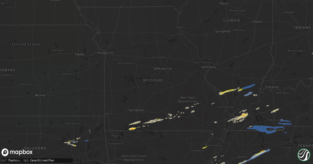
Hail Map in Missouri on December 5, 2021
Get this storm
December 5 map
$229
one time, instant access
Download today. No call, no setup
Keep the $229
Bought the map and want the full workflow? Apply the entire $229 to a subscription within 7 days. None of it is wasted.
Every map, not just this one
This buys you this map. Subscription and you get every map we run, in the markets you choose from a few cities to whole states to nationwide. Plus real-time alerts the moment a storm fires.
Contact data
Name, contact info, occupancy, even credit band for addresses in the footprint. You go from where it hit to who to call.
Become the source they trust
Unlimited branding weather history reports on demand. You already have the documented answer ready for the property owner, and you are the one who showed up with it.
Property data and RoofTrace estimates
Pull up any address you have got, its value and the exact code rules for that jurisdiction, straight from One Click Code. Then RoofTrace estimates the squares, pitch, and roof value, priced the way you price.
Storm reports in Missouri
Missouri
| Date | Description |
|---|---|
| 12/05/20214:00 AM CST | At 1000 PM CST, a severe thunderstorm was located 7 miles west of Altenburg, or 10 miles southeast of Perryville, moving east at 55 mph. HAZARD...60 mph wind gusts and penny size hail. SOURCE...Radar indicated. IMPACT...Expect damage to roofs, siding, and trees. This severe thunderstorm will be near... Altenburg around 1010 PM CST. Grand Tower around 1015 PM CST.Other locations in the path of this severe thunderstorm includeMurphysboro and Cedar Lake Area.This includes Interstate 55 between Mile Markers 115 and 123. |
| 12/05/20213:57 AM CST | At 956 PM CST, severe thunderstorms were located along a line extending from near Buckhorn to near Garwood, moving east at 40 mph. HAZARD...60 mph wind gusts and penny size hail. SOURCE...Radar indicated. IMPACT...Expect damage to roofs, siding, and trees. Severe thunderstorms will be near... Cascade around 1005 PM CST.Other locations in the path of these severe thunderstorms includeGreenville and Shook. |
| 12/05/20213:50 AM CST | At 949 PM CST, a severe thunderstorm was located 7 miles south of Kimberling City, moving east at 45 mph. HAZARD...60 mph wind gusts and quarter size hail. SOURCE...Radar indicated. IMPACT...Hail damage to vehicles is expected. Expect wind damage to roofs, siding, and trees. Locations impacted include... Branson... Table Rock Lake... Lake Taneycomo... Bull Shoals Lake... Table Rock State Park... Hollister... Forsyth... Kissee Mills... Indian Point... Table Rock... Kirbyville... Blue Eye... Coney Island... Powersite... Protem... Lampe... Rueter... Ridgedale... Ozark Beach... Edgewater Beach... |
| 12/05/20213:03 AM CST | At 903 PM CST, a severe thunderstorm was located 11 miles south of Ava, moving east at 35 mph. HAZARD...60 mph wind gusts and quarter size hail. SOURCE...Radar indicated. IMPACT...Hail damage to vehicles is expected. Expect wind damage to roofs, siding, and trees. Locations impacted include... Wasola... Brixey... Noble... Squires... Dora... Rockbridge... Drury... Gentryville... |
| 12/05/20212:57 AM CST | At 855 PM CST, a severe thunderstorm was located over Reeds Spring, or near Kimberling City, moving east at 35 mph. HAZARD...60 mph wind gusts and quarter size hail. SOURCE...Radar indicated. IMPACT...Hail damage to vehicles is expected. Expect wind damage to roofs, siding, and trees. Locations impacted include... Table Rock Lake... Reeds Spring... Branson West... |
| 12/05/20212:48 AM CST | At 847 PM CST, a severe thunderstorm was located near Merriam Woods, or 7 miles northwest of Forsyth, moving east at 40 mph. HAZARD...60 mph wind gusts and quarter size hail. SOURCE...Radar indicated. IMPACT...Hail damage to vehicles is expected. Expect wind damage to roofs, siding, and trees. Locations impacted include... Taneyville... Goodhope... Garrison... Rome... Brownbranch... Bradleyville... |
| 12/04/202110:14 PM CST | A local report indicates 1.25 inch wind near TABLE ROCK |
| 12/04/202110:10 PM CST | A local report indicates 1.25 inch wind near 4 N BLUE EYE |
| 12/04/202110:06 PM CST | A local report indicates 1.25 inch wind near 1 ESE TABLE ROCK |
| 12/04/202110:03 PM CST | A local report indicates 1.00 inch wind near TABLE ROCK |
| 12/04/202110:02 PM CST | A nws survey confirmed that an ef-1 tornado touched down northeast of highlandville and caused extensive damage to the roof of an outbuilding. The tornado continued eas |
| 12/04/20219:57 PM CST | A local report indicates 1.75 inch wind near 4 N BLUE EYE |
| 12/04/20219:48 PM CST | A local report indicates 1.00 inch wind near DRURY |
All States Impacted by Hail Map on December 5, 2021
Cities Impacted by Hail Map on December 5, 2021
- Eminence, MO
- Blue Eye, MO
- Lampe, MO
- Covington, TN
- Hollister, MO
- Lake City, AR
- Monette, AR
- Fancy Farm, KY
- Arlington, KY
- Bardwell, KY
- Melber, KY
- Cunningham, KY
- Hickory, KY
- Memphis, TN
- Millington, TN
- White Plains, KY
- Graham, KY
- Nortonville, KY
- Dora, MO
- Drury, MO
- Wickliffe, KY
- Pomona, MO
- Mountain View, MO
- Branson, MO
- Shell Knob, MO
- Kimberling City, MO
- Reeds Spring, MO
- Adair, OK
- Linden, TN
- Lobelville, TN
- Marion, KY
- Squires, MO
- Ava, MO
- Paducah, KY
- Wasola, MO
- Kevil, KY
- Perryville, MO
- Ava, IL
- Murphysboro, IL
- Frohna, MO
- Rockwood, IL
- Jacob, IL
- Crofton, KY
- Greenville, KY
- Saint Charles, KY
- Scipio, IN
- Elizabethtown, IN
- Orient, IL
- West Frankfort, IL
- Johnston City, IL
- West Paducah, KY
- Columbus, KY
- East Prairie, MO
- Charleston, MO
- Anniston, MO
- Boaz, KY
- La Center, KY
- Annapolis, MO
- Farmington, KY
- Murray, KY
- Kirksey, KY
- Salem, KY
- Fredonia, KY
- Parsons, TN
- Elkville, IL
- Royalton, IL
- De Soto, IL
- Zeigler, IL
- Catoosa, OK
- Claremore, OK
- Owasso, OK
- Farrar, MO
- Vergennes, IL
- Winona, MO
- Thornfield, MO
- Tulsa, OK
- Medon, TN
- Toone, TN
- Equality, IL
- Junction, IL
- Shawneetown, IL
- Sugar Tree, TN
- Darden, TN
- Drummonds, TN
- Danville, KY
- Willow Springs, MO
- Providence, KY
- Nebo, KY
- Brookport, IL
- Benton, IL
- Dudley, MO
- Walnut Shade, MO
- Birch Tree, MO
- Metropolis, IL
- Essex, MO
- Dexter, MO
- Jenks, OK
- Sand Springs, OK
- Sapulpa, OK
- Broken Arrow, OK
- Bixby, OK
- Henning, TN
- Ellington, MO
- Theodosia, MO
- Cape Fair, MO
- Galena, MO
- Hughes, AR
- Heth, AR
- Lesterville, MO
- New Albany, MS
- Myrtle, MS
- Westport, IN
- North Vernon, IN
- Seymour, IN
- Forsyth, MO
- Kissee Mills, MO
- Bradleyville, MO
- Rueter, MO
- Wilson, AR
- Noble, MO
- Taneyville, MO
- Lexington, TN
- Redford, MO
- Kirbyville, MO
- Patton, MO
- Marble Hill, MO
- Scotts Hill, TN
- Arcadia, MO
- Proctor, AR
- Mason, TN
- Arlington, TN
- Brighton, TN
- Henderson, TN
- Pinson, TN
- Atoka, TN
- Holcomb, MO
- Piggott, AR
- Vanzant, MO
- Norwood, MO
- Luray, TN
- Only, TN
- Huron, TN
- Decaturville, TN
- Centerville, TN
- Hurricane Mills, TN
- Reagan, TN
- Jacks Creek, TN
- Beech Bluff, TN
- Tennessee Ridge, TN
- Almo, KY
- Sedalia, KY
- Adams, TN
- Indian Mound, TN
- Hazel, KY
- Clarksville, TN
- New Concord, KY
- Cadiz, KY
- Palmyra, TN
- Mayfield, KY
- Bumpus Mills, TN
- Big Rock, TN
- Cedar Hill, TN
- Buchanan, TN
- Woodlawn, TN
- Cumberland City, TN
- Dover, TN
- Springfield, TN
- Pleasant View, TN
- Greenbrier, TN
- Inola, OK
- Chouteau, OK
- Harrisburg, IL
- Eldorado, IL
- Carrier Mills, IL
- Stonefort, IL
- Norris City, IL
- Enfield, IL
- Broughton, IL
- Dale, IL
- McLeansboro, IL
- Macedonia, IL
- Thompsonville, IL
- Olmstead, KY
- Guthrie, KY
- Pembroke, KY
- Allensville, KY
- Russellville, KY
- Adairville, KY
- Elkton, KY
- Trenton, KY
- Franklin, KY
- Lewisburg, KY
- Auburn, KY
- Leachville, AR
- Potts Camp, MS
- Guntown, MS
- Hickory Flat, MS
- Dumas, MS
- Blue Springs, MS
- Ecru, MS


