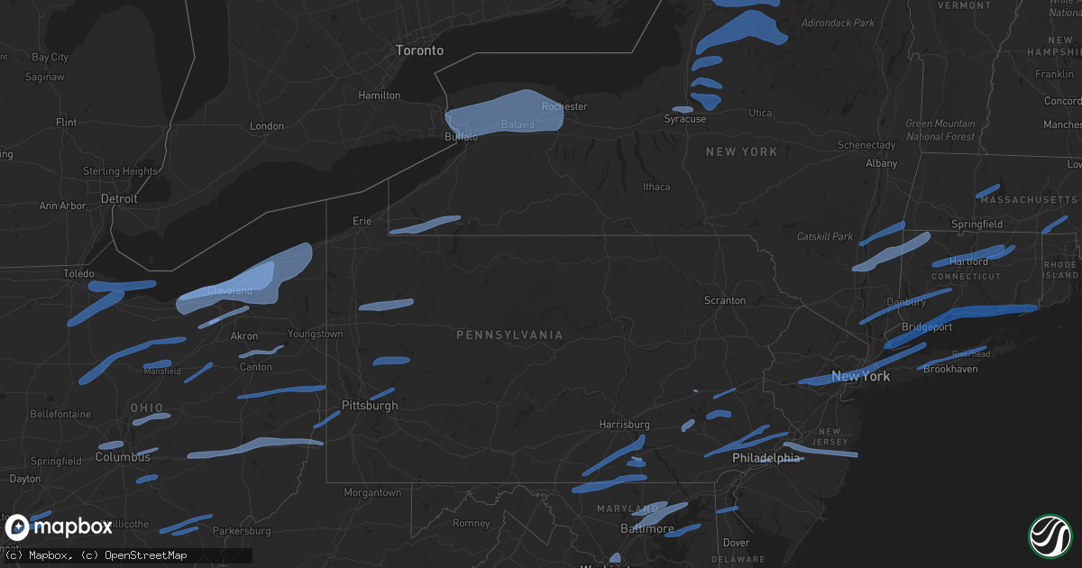
Hail Map in Connecticut on November 15, 2020
Get this storm
November 15 map
$229
one time, instant access
Download today. No call, no setup
Keep the $229
Bought the map and want the full workflow? Apply the entire $229 to a subscription within 7 days. None of it is wasted.
Every map, not just this one
This buys you this map. Subscription and you get every map we run, in the markets you choose from a few cities to whole states to nationwide. Plus real-time alerts the moment a storm fires.
Contact data
Name, contact info, occupancy, even credit band for addresses in the footprint. You go from where it hit to who to call.
Become the source they trust
Unlimited branding weather history reports on demand. You already have the documented answer ready for the property owner, and you are the one who showed up with it.
Property data and RoofTrace estimates
Pull up any address you have got, its value and the exact code rules for that jurisdiction, straight from One Click Code. Then RoofTrace estimates the squares, pitch, and roof value, priced the way you price.
Storm reports in Connecticut
Connecticut
| Date | Description |
|---|---|
| 11/15/20204:24 AM CST | At 1024 PM EST, severe thunderstorms were located along a line extending from near Southbridge to Preston to Gardner's Island, moving east at 45 mph. HAZARD...60 mph wind gusts. SOURCE...Radar indicated. IMPACT...Expect damage to trees and power lines. Locations impacted include... Providence, New Bedford, Brockton, Fall River, Warwick, Cranston, Pawtucket, Taunton, Weymouth, East Providence, Woonsocket, Coventry, Dartmouth, Cumberland, Randolph, North Providence, Franklin, South Kingstown, West Warwick and Johnston. |
| 11/15/20204:22 AM CST | At 1022 PM EST, severe thunderstorms were located along a line extending from New Ipswich to Princeton to near Woodstock, moving east at 50 mph. HAZARD...60 mph wind gusts. SOURCE...Radar indicated. IMPACT...Expect damage to trees and power lines. Locations impacted include... Boston, Worcester, Lowell, Cambridge, Brockton, Quincy, Lynn, Newton, Lawrence, Somerville, Framingham, Haverhill, Waltham, Malden, Brookline, Medford, Weymouth, Revere, Peabody and Methuen. |
| 11/15/20203:41 AM CST | At 940 PM EST, severe thunderstorms were located along a line extending from Wethersfield to near Branford, moving east at 60 mph. HAZARD...60 mph wind gusts. SOURCE...Radar indicated. IMPACT...Expect damage to trees and power lines. Severe thunderstorms will be near... East Hampton and Cromwell around 945 PM EST. Clinton and North Madison around 955 PM EST. Old Saybrook and Westbrook around 1000 PM EST. Chester and Old Lyme around 1005 PM EST. Lyme and North Lyme around 1010 PM EST. Waterford and East Lyme around 1015 PM EST. New London and Groton around 1020 PM EST. Ledyard Center around 1025 PM EST. Ledyard around 1030 PM EST. |
| 11/15/20203:29 AM CST | At 928 PM EST, severe thunderstorms were located along a line extending from near Goshen to Westfield to near Granby, moving east at 45 mph. HAZARD...60 mph wind gusts. SOURCE...Radar indicated. IMPACT...Expect damage to trees and power lines. Locations impacted include... Springfield, Chicopee, Enfield, Westfield, Holyoke, Amherst, Northampton, Agawam, West Springfield, Ludlow, South Hadley, Easthampton, Longmeadow, Suffield, East Longmeadow, Belchertown, Wilbraham, Palmer, Stafford and Somers. |
| 11/15/20202:41 AM CST | At 840 PM EST, severe thunderstorms were located along a line extending from Lake Carmel to near Sandy Hook, moving east at 70 mph. HAZARD...60 mph wind gusts. SOURCE...Radar indicated. IMPACT...Expect damage to trees and power lines. Severe thunderstorms will be near... Brewster around 845 PM EST. Danbury and Bethel around 850 PM EST. Long Beach and Newtown around 855 PM EST. Freeport and Jones Beach around 900 PM EST. Massapequa and Southbury around 905 PM EST. Waterbury and Lindenhurst around 910 PM EST. Islip and Brentwood around 915 PM EST. Ronkonkoma and Sayville around 920 PM EST. Patchogue and Holbrook around 925 PM EST. Shirley and Medford around 930 PM EST. Manorville and Center Moriches around 935 PM EST. Calverton around 940 PM EST. |
| 11/15/20201:57 AM CST | At 757 PM EST, severe thunderstorms were located along a line extending from 6 miles northwest of Wallkill to near Franklin to Chester to near Bridgewater to near Doylestown, moving east at 55 mph. HAZARD...60 mph wind gusts. SOURCE...Radar indicated. IMPACT...Expect damage to trees and power lines. Severe thunderstorms will be near... West Milford around 800 PM EST. Upper Greenwood Lake around 805 PM EST. Plainfield and Ringwood around 810 PM EST. Summit and Millburn around 815 PM EST. Orange and Monsey around 820 PM EST. Newark and Paterson around 825 PM EST. Jersey City and Passaic around 830 PM EST. Hoboken and Hackensack around 835 PM EST. Mott Haven and Nanuet around 840 PM EST. Yonkers and East Tremont around 845 PM EST. New Rochelle and White Plains around 850 PM EST. Todt Hill and Port Richmond around 855 PM EST. |
| 11/14/202010:06 PM CST | Tree down on power lines on route 198 and hawkins road |
| 11/14/20209:08 PM CST | Tree down on wires on cooper lane |
| 11/14/20208:55 PM CST | Tree down on wires on springfield road |
| 11/14/20208:48 PM CST | Tree down on wires on cubles drive |
| 11/14/20208:48 PM CST | Tree down on tyler street |
| 11/14/20208:48 PM CST | Tree and wires down on buff cap road |
| 11/14/20208:44 PM CST | Large tree blocking the road on route 17 |
| 11/14/20208:42 PM CST | Tree and wires down on walredge road |
| 11/14/20208:31 PM CST | Several trees down across the city |
| 11/14/20208:30 PM CST | Tree on wires on claire hill road |
| 11/14/20208:15 PM CST | Tree downed on wires on new harwinton road |
| 11/14/20208:14 PM CST | Bdr asos recorded a 61 mph wind gust. |
| 11/14/20208:10 PM CST | Tree downed on bantam road |
| 11/14/20208:09 PM CST | Tree downed on bantam road |
| 11/14/20208:06 PM CST | Tree and wires down on route 202 |
| 11/14/20208:03 PM CST | Tree down on route 44 at toll house lane |
| 11/14/20208:00 PM CST | Downed tree on wires resulting in fire |
| 11/14/20207:59 PM CST | Tree and wires down on west chippens hill road |
| 11/14/20207:57 PM CST | Trained spotter reports trees and power lines down near sound beach ave and across benjamin st. Time estimated by radar. |
| 11/14/20207:56 PM CST | A tree and wires were downed on lower road |
| 11/14/20207:54 PM CST | Tree and wires down on devine avenue |
| 11/14/20207:51 PM CST | Tree down on route 7 |
| 11/14/20207:49 PM CST | Downed trees and wires |
| 11/14/20207:46 PM CST | Numerous tree limbs down on jackson hill road |
| 11/14/20207:18 PM CST | Large branches greater than 2 inches in diameter down |
| 11/14/20206:55 PM CST | Trees and wires down. Time estimated by radar. |
All States Impacted by Hail Map on November 15, 2020
Cities Impacted by Hail Map on November 15, 2020
- Amherst, MA
- Shutesbury, MA
- Hadley, MA
- Mendon, MA
- Uxbridge, MA
- Douglas, MA
- Hopedale, MA
- Milford, MA
- Whitinsville, MA
- Northbridge, MA
- Sutton, MA
- Upton, MA
- Middleport, NY
- Stafford, NY
- West Henrietta, NY
- Alden, NY
- Kendall, NY
- Sanborn, NY
- Rochester, NY
- Alexander, NY
- Rush, NY
- Avon, NY
- Tonawanda, NY
- Gasport, NY
- Batavia, NY
- Getzville, NY
- East Bethany, NY
- Medina, NY
- Clarence, NY
- Scottsville, NY
- Spencerport, NY
- Corfu, NY
- Caledonia, NY
- Depew, NY
- Bergen, NY
- Grand Island, NY
- Henrietta, NY
- North Chili, NY
- Buffalo, NY
- South Byron, NY
- East Pembroke, NY
- Pavilion, NY
- Byron, NY
- North Tonawanda, NY
- Holley, NY
- Niagara Falls, NY
- Oakfield, NY
- Clarence Center, NY
- Churchville, NY
- Kent, NY
- Knowlesville, NY
- Honeoye Falls, NY
- Elba, NY
- East Amherst, NY
- Lockport, NY
- Basom, NY
- Hilton, NY
- Bowmansville, NY
- Brockport, NY
- Mumford, NY
- Le Roy, NY
- Albion, NY
- Akron, NY
- Lancaster, NY
- Jamestown, NY
- Randolph, NY
- Panama, NY
- Ashville, NY
- Clymer, NY
- Falconer, NY
- Frewsburg, NY
- Lakewood, NY
- Kennedy, NY
- Celoron, NY
- Baldwinsville, NY
- Cicero, NY
- Liverpool, NY
- East Syracuse, NY
- Syracuse, NY
- Constantia, NY
- Bernhards Bay, NY
- West Monroe, NY
- Camden, NY
- Westdale, NY
- Parish, NY
- Williamstown, NY
- Cleveland, NY
- Blossvale, NY
- Chittenango, NY
- Durhamville, NY
- Canastota, NY
- Verona Beach, NY
- Bridgeport, NY
- North Bay, NY
- Sylvan Beach, NY
- Edwards, NY
- Gouverneur, NY
- Harrisville, NY
- Carthage, NY
- Fort Drum, NY
- Wanakena, NY
- Watertown, NY
- Natural Bridge, NY
- Evans Mills, NY
- Oswegatchie, NY
- Philadelphia, NY
- Pulaski, NY
- Richland, NY
- Redfield, NY
- Altmar, NY
- Glenfield, NY
- Adams, NY
- Lorraine, NY
- Croghan, NY
- Mannsville, NY
- Eagle Bay, NY
- Thendara, NY
- Lowville, NY
- Castorland, NY
- Lacona, NY
- Copenhagen, NY
- Old Forge, NY
- Rodman, NY
- Worton, MD
- Kennedyville, MD
- Chestertown, MD
- Still Pond, MD
- West River, MD
- Temple Hills, MD
- Hyattsville, MD
- Suitland, MD
- Lothian, MD
- Upper Marlboro, MD
- Capitol Heights, MD
- District Heights, MD
- Harwood, MD
- Chalfont, PA
- Berwyn, PA
- Gwynedd, PA
- Exton, PA
- Flourtown, PA
- Fort Washington, PA
- Conshohocken, PA
- Willow Grove, PA
- Bryn Athyn, PA
- Malvern, PA
- King Of Prussia, PA
- Montgomeryville, PA
- Lafayette Hill, PA
- Southampton, PA
- Abington, PA
- Downingtown, PA
- Phoenixville, PA
- Warrington, PA
- Thorndale, PA
- Chester Springs, PA
- Norristown, PA
- West Chester, PA
- Paoli, PA
- Blue Bell, PA
- Feasterville Trevose, PA
- Huntingdon Valley, PA
- Oreland, PA
- Parkesburg, PA
- Glenside, PA
- Langhorne, PA
- Devon, PA
- North Wales, PA
- Plymouth Meeting, PA
- Bridgeport, PA
- Oaks, PA
- Dresher, PA
- Coatesville, PA
- Ambler, PA
- Immaculata, PA
- Spring House, PA
- Lansdale, PA
- Wayne, PA
- Bechtelsville, PA
- Douglassville, PA
- Oley, PA
- Gilbertsville, PA
- Boyertown, PA
- Reading, PA
- Barto, PA
- Birdsboro, PA
- Adamstown, PA
- Wernersville, PA
- Reinholds, PA
- Denver, PA
- Ephrata, PA
- Stevens, PA
- York Haven, PA
- New Oxford, PA
- Gettysburg, PA
- Dover, PA
- Manchester, PA
- Wellsville, PA
- Fairfield, PA
- East Berlin, PA
- Middletown, PA
- Elizabethtown, PA
- Mount Wolf, PA
- Bainbridge, PA
- York, PA
- Kutztown, PA
- Allentown, PA
- Mertztown, PA
- Breinigsville, PA
- Philadelphia, PA
- Camden, NJ
- Brooklyn, NY
- Union City, NJ
- Summit, NJ
- Bridgewater, NJ
- Gillette, NJ
- Roselle, NJ
- Oldwick, NJ
- Millburn, NJ
- Watchung, NJ
- Bronx, NY
- Warren, NJ
- Fanwood, NJ
- Jackson Heights, NY
- Basking Ridge, NJ
- Union, NJ
- Great Neck, NY
- Sea Cliff, NY
- Maspeth, NY
- Sunnyside, NY
- Whitehouse Station, NJ
- Bedminster, NJ
- Long Island City, NY
- Millington, NJ
- Springfield, NJ
- North Bergen, NJ
- Bayside, NY
- Port Washington, NY
- Irvington, NJ
- Woodside, NY
- Westfield, NJ
- Whitestone, NY
- Kenilworth, NJ
- Mill Neck, NY
- Elizabeth, NJ
- Scotch Plains, NJ
- East Elmhurst, NY
- Newark, NJ
- Hoboken, NJ
- Bayville, NY
- Hillside, NJ
- Berkeley Heights, NJ
- Maplewood, NJ
- Cranford, NJ
- Far Hills, NJ
- Harrison, NJ
- Flushing, NY
- Vauxhall, NJ
- Short Hills, NJ
- Bayonne, NJ
- Locust Valley, NY
- Glen Cove, NY
- Garwood, NJ
- Jersey City, NJ
- Northport, NY
- Glen Head, NY
- Secaucus, NJ
- Oyster Bay, NY
- Plainfield, NJ
- Glenwood Landing, NY
- Astoria, NY
- Elmhurst, NY
- Weehawken, NJ
- New Providence, NJ
- Huntington, NY
- New York, NY
- Roselle Park, NJ
- Lebanon, NJ
- Stirling, NJ
- Corona, NY
- Califon, NJ
- Kearny, NJ
- College Point, NY
- Chatham, NJ
- Mountainside, NJ
- Manhasset, NY
- Montrose, NY
- Pomona, NY
- Granite Springs, NY
- Somers, NY
- Yorktown Heights, NY
- Cheshire, CT
- Oxford, CT
- Southbury, CT
- Cortlandt Manor, NY
- Garnerville, NY
- Croton On Hudson, NY
- Haverstraw, NY
- Amawalk, NY
- Beacon Falls, CT
- West Haverstraw, NY
- Sandy Hook, CT
- Stony Point, NY
- Prospect, CT
- North Salem, NY
- Naugatuck, CT
- Bethel, CT
- Danbury, CT
- Katonah, NY
- Brewster, NY
- Newtown, CT
- New City, NY
- Purdys, NY
- Ridgefield, CT
- Thiells, NY
- Pemberton, NJ
- Lumberton, NJ
- Vincentown, NJ
- Medford, NJ
- Cherry Hill, NJ
- Mount Laurel, NJ
- Croydon, PA
- Seaside Heights, NJ
- Burlington, NJ
- Lakehurst, NJ
- Columbus, NJ
- Joint Base Mdl, NJ
- Mount Holly, NJ
- Bristol, PA
- Jobstown, NJ
- Wrightstown, NJ
- Bensalem, PA
- Toms River, NJ
- Lavallette, NJ
- Beverly, NJ
- Manchester Township, NJ
- Bordentown, NJ
- Cookstown, NJ
- Townsend, DE
- Salem, NJ
- Odessa, DE
- Middletown, DE
- Bolton, CT
- Harwinton, CT
- Ellington, CT
- Northfield, CT
- Manchester, CT
- East Hartford, CT
- Willington, CT
- Windsor, CT
- Coventry, CT
- Burlington, CT
- Farmington, CT
- Litchfield, CT
- South Windsor, CT
- Unionville, CT
- Storrs Mansfield, CT
- Avon, CT
- Vernon Rockville, CT
- Hartford, CT
- Tolland, CT
- West Hartford, CT
- Bloomfield, CT
- Islandia, NY
- Nesconset, NY
- Calverton, NY
- Middle Island, NY
- Bay Shore, NY
- Centereach, NY
- Holbrook, NY
- Central Islip, NY
- Ronkonkoma, NY
- Medford, NY
- Deer Park, NY
- Selden, NY
- Lake Grove, NY
- South Jamesport, NY
- Manorville, NY
- Laurel, NY
- Huntington Station, NY
- Coram, NY
- Smithtown, NY
- Brentwood, NY
- Hauppauge, NY
- Riverhead, NY
- Ridge, NY
- Jamesport, NY
- Farmingville, NY
- Mattituck, NY
- Eastford, CT
- Ashford, CT
- Fairfield, CT
- Riverside, CT
- Guilford, CT
- East Lyme, CT
- Madison, CT
- Darien, CT
- Pawcatuck, CT
- Westport, CT
- Norwalk, CT
- Essex, CT
- Stamford, CT
- Stonington, CT
- Southport, CT
- Milford, CT
- Westbrook, CT
- Killingworth, CT
- Niantic, CT
- Ivoryton, CT
- Harrison, NY
- Port Chester, NY
- Bridgeport, CT
- Groton, CT
- West Haven, CT
- Old Lyme, CT
- Old Saybrook, CT
- East Haven, CT
- Stratford, CT
- Centerbrook, CT
- Branford, CT
- Greenwich, CT
- Rye, NY
- Waterford, CT
- New Haven, CT
- Northford, CT
- New London, CT
- North Branford, CT
- Clinton, CT
- Orange, CT
- Old Greenwich, CT
- Deep River, CT
- Mystic, CT
- Cos Cob, CT
- Rhinebeck, NY
- Millerton, NY
- Kingston, NY
- Ancramdale, NY
- Port Ewen, NY
- Ancram, NY
- South Egremont, MA
- Pine Plains, NY
- Copake Falls, NY
- Copake, NY
- Red Hook, NY
- Wassaic, NY
- West Cornwall, CT
- Stanfordville, NY
- Highland, NY
- Clintondale, NY
- Millbrook, NY
- Clinton Corners, NY
- Milton, NY
- Amenia, NY
- Poughkeepsie, NY
- Norfolk, CT
- Falls Village, CT
- Sharon, CT
- Salt Point, NY
- East Canaan, CT
- New Paltz, NY
- Modena, NY
- Hyde Park, NY
- Lakeville, CT
- Pleasant Valley, NY
- Bel Air, MD
- White Marsh, MD
- Joppa, MD
- Catonsville, MD
- Towson, MD
- Gwynn Oak, MD
- Belcamp, MD
- Glen Arm, MD
- Nottingham, MD
- Baltimore, MD
- Parkville, MD
- Aberdeen Proving Ground, MD
- Perry Hall, MD
- Rosedale, MD
- Aberdeen, MD
- Kingsville, MD
- Edgewood, MD
- Havre De Grace, MD
- Abingdon, MD
- Windsor Mill, MD
- Upper Falls, MD
- Cockeysville, MD
- Forest Hill, MD
- Hydes, MD
- Fallston, MD
- Lutherville Timonium, MD
- Baldwin, MD
- Owings Mills, MD
- Fork, MD
- Phoenix, MD
- Stevenson, MD
- Takoma Park, MD
- Silver Spring, MD
- Washington, DC
- Chevy Chase, MD
- College Park, MD
- New Freedom, PA
- Stewartstown, PA
- Glenville, PA
- Hanover, PA
- Glen Rock, PA
- Sabillasville, MD
- Shrewsbury, PA
- Keymar, MD
- Manchester, MD
- Rocky Ridge, MD
- Railroad, PA
- Thurmont, MD
- Smithsburg, MD
- Emmitsburg, MD
- Taneytown, MD
- Littlestown, PA
- Westminster, MD
- Spring Grove, PA
- Seven Valleys, PA
- Red Lion, PA
- Dallastown, PA
- York New Salem, PA
- Columbus, OH
- Hilliard, OH
- Dublin, OH
- Amlin, OH
- Plain City, OH
- Sheffield Lake, OH
- Columbia Station, OH
- Thompson, OH
- Middlefield, OH
- Grafton, OH
- Geneva, OH
- Novelty, OH
- Avon Lake, OH
- Wickliffe, OH
- Ashtabula, OH
- Brookpark, OH
- Huntsburg, OH
- Burton, OH
- Amherst, OH
- Westlake, OH
- Gates Mills, OH
- Solon, OH
- Jefferson, OH
- Euclid, OH
- Beachwood, OH
- Bedford, OH
- Grand River, OH
- Montville, OH
- Kingsville, OH
- Wakeman, OH
- Rock Creek, OH
- Avon, OH
- Chardon, OH
- Vermilion, OH
- Windsor, OH
- Rocky River, OH
- Lakewood, OH
- Newbury, OH
- Hiram, OH
- Olmsted Falls, OH
- Berea, OH
- North Ridgeville, OH
- Maple Heights, OH
- Chagrin Falls, OH
- Eastlake, OH
- Painesville, OH
- Lorain, OH
- Madison, OH
- Bay Village, OH
- Austinburg, OH
- Willoughby, OH
- Independence, OH
- Chesterland, OH
- Rome, OH
- Lagrange, OH
- Oberlin, OH
- North Olmsted, OH
- Mentor, OH
- Elyria, OH
- Perry, OH
- Cleveland, OH
- Lancaster, OH
- Amanda, OH
- Carroll, OH
- Canal Winchester, OH
- Granville, OH
- Blacklick, OH
- Pataskala, OH
- Reynoldsburg, OH
- Sunbury, OH
- Gambier, OH
- Mount Vernon, OH
- Centerburg, OH
- Medina, OH
- North Royalton, OH
- Litchfield, OH
- Richfield, OH
- Brunswick, OH
- Brecksville, OH
- Hinckley, OH
- Twinsburg, OH
- Broadview Heights, OH
- Northfield, OH
- Macedonia, OH
- Valley City, OH
- Hartville, OH
- North Canton, OH
- Massillon, OH
- North Benton, OH
- Canton, OH
- Clinton, OH
- Canal Fulton, OH
- Alliance, OH
- Louisville, OH
- Uniontown, OH
- Carrollton, OH
- New Philadelphia, OH
- Hammondsville, OH
- Mineral City, OH
- East Liverpool, OH
- Dover, OH
- Chester, WV
- Sugarcreek, OH
- Dellroy, OH
- Irondale, OH
- Newell, WV
- Salineville, OH
- Wellsville, OH
- New Cumberland, WV
- Sherrodsville, OH
- Mechanicstown, OH
- Brilliant, OH
- Burgettstown, PA
- Bulger, PA
- Rayland, OH
- Avella, PA
- Langeloth, PA
- Slovan, PA
- Beech Bottom, WV
- Joffre, PA
- Wellsburg, WV
- Colliers, WV
- Glenshaw, PA
- Pittsburgh, PA
- Tarentum, PA
- Cheswick, PA
- Springdale, PA
- Oakmont, PA
- Harwick, PA
- New Kensington, PA
- Creighton, PA
- Adrian, PA
- East Butler, PA
- Butler, PA
- Cowansville, PA
- Renfrew, PA
- Cabot, PA
- Lyndora, PA
- Worthington, PA
- Kittanning, PA
- Fenelton, PA
- Sandy Lake, PA
- Oil City, PA
- Polk, PA
- Cranberry, PA
- Tionesta, PA
- Seneca, PA
- Franklin, PA
- Stoneboro, PA
- Venus, PA
- Kennerdell, PA
- Hamburg, PA
- Port Clinton, PA
- Bethesda, OH
- Quaker City, OH
- Wheeling, WV
- Hopewell, OH
- Old Washington, OH
- Piedmont, OH
- New Concord, OH
- Salesville, OH
- Flushing, OH
- Martins Ferry, OH
- Cambridge, OH
- Adamsville, OH
- Bridgeport, OH
- Barnesville, OH
- Freeport, OH
- Norwich, OH
- Lore City, OH
- Saint Clairsville, OH
- Belmont, OH
- Triadelphia, WV
- Zanesville, OH
- Heath, OH
- Valley Grove, WV
- New Marshfield, OH
- McArthur, OH
- Albany, OH
- Athens, OH
- Millfield, OH
- Amesville, OH
- New Plymouth, OH
- Zaleski, OH
- The Plains, OH
- Ashland, OH
- Crestline, OH
- Shelby, OH
- Mansfield, OH
- Wooster, OH
- Loudonville, OH
- Shreve, OH
- Lakeville, OH
- Clarksville, OH
- Wilmington, OH
- Morrow, OH
- Oregonia, OH
- Cincinnati, OH
- Maineville, OH
- Blanchester, OH
- Loveland, OH
- Pleasant Plain, OH
- Goshen, OH
- Graytown, OH
- Lacarne, OH
- Port Clinton, OH
- Rocky Ridge, OH
- Martin, OH
- Lakeside Marblehead, OH
- Elmore, OH
- Clay Center, OH
- Woodville, OH
- Genoa, OH
- Millbury, OH
- Oak Harbor, OH
- Bradner, OH
- Van Buren, OH
- Cygnet, OH
- Gibsonburg, OH
- Bloomdale, OH
- Risingsun, OH
- North Baltimore, OH
- Kansas, OH
- Helena, OH
- Lindsey, OH
- Wayne, OH
- West Millgrove, OH
- Fremont, OH
- Fostoria, OH
- Kenton, OH
- Sullivan, OH
- New London, OH
- Sycamore, OH
- Nevada, OH
- Bucyrus, OH
- New Washington, OH
- Bloomville, OH
- Tiro, OH
- Harpster, OH
- Chatfield, OH
- Willard, OH
- Shiloh, OH
- Plymouth, OH
- Nova, OH
- Forest, OH
- La Rue, OH
- Upper Sandusky, OH
- Greenwich, OH


