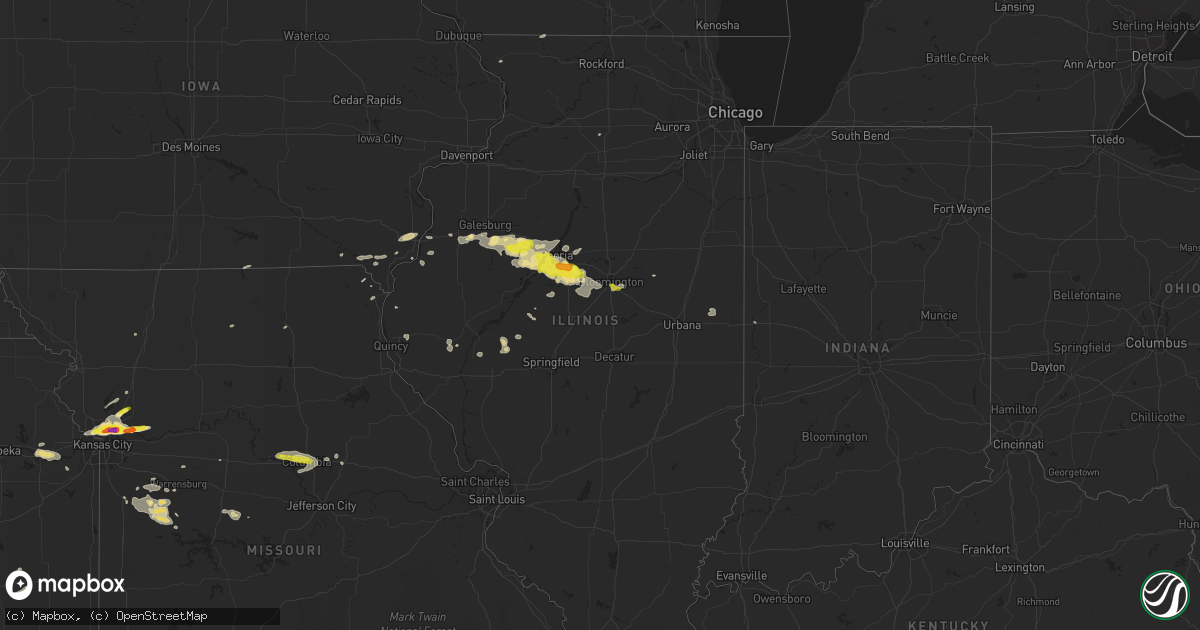
Hail Map in Illinois on November 2, 2016
Get this storm
November 2 map
$229
one time, instant access
Download today. No call, no setup
Keep the $229
Bought the map and want the full workflow? Apply the entire $229 to a subscription within 7 days. None of it is wasted.
Every map, not just this one
This buys you this map. Subscription and you get every map we run, in the markets you choose from a few cities to whole states to nationwide. Plus real-time alerts the moment a storm fires.
Contact data
Name, contact info, occupancy, even credit band for addresses in the footprint. You go from where it hit to who to call.
Become the source they trust
Unlimited branding weather history reports on demand. You already have the documented answer ready for the property owner, and you are the one who showed up with it.
Property data and RoofTrace estimates
Pull up any address you have got, its value and the exact code rules for that jurisdiction, straight from One Click Code. Then RoofTrace estimates the squares, pitch, and roof value, priced the way you price.
Storm reports in Illinois
Illinois
| Date | Description |
|---|---|
| 11/02/20166:37 PM CDT | Tree limb blown down |
| 11/02/20165:52 PM CDT | Tree limbs and power lines down on the south side of town |
| 11/02/20165:30 PM CDT | A local report indicates 1.00 inch wind near DOWNS |
| 11/02/20164:35 PM CDT | A local report indicates 1.50 inch wind near 1 E MORTON |
| 11/02/20164:30 PM CDT | A local report indicates 1.75 inch wind near MORTON |
| 11/02/20164:28 PM CDT | A local report indicates 1.00 inch wind near GROVELAND |
| 11/02/20164:27 PM CDT | On i-74 mm 98 |
| 11/02/20164:25 PM CDT | Tree blown down blocking one lane os chatham road. Time estimated. |
| 11/02/20164:19 PM CDT | A local report indicates 1.00 inch wind near PEORIA INTERNATIONAL AI |
| 11/02/20164:15 PM CDT | A local report indicates 1.25 inch wind near MAPLETON |
| 11/02/20164:05 PM CDT | A local report indicates 1.25 inch wind near HANNA CITY |
All States Impacted by Hail Map on November 2, 2016
Cities Impacted by Hail Map on November 2, 2016
- Galesburg, IL
- Tonganoxie, KS
- Linwood, KS
- Lawrence, KS
- Knox City, TX
- Seymour, TX
- Goree, TX
- Munday, TX
- Pekin, IL
- Groveland, IL
- Tremont, IL
- Morton, IL
- Big Spring, TX
- Andrews, TX
- Childress, TX
- Fluvanna, TX
- Snyder, TX
- Crosbyton, TX
- Stephenville, TX
- Hico, TX
- Maquon, IL
- Odonnell, TX
- Lamesa, TX
- Welch, TX
- Liberty, MO
- Turkey, TX
- Tahoka, TX
- Post, TX
- Garden City, MO
- Iredell, TX
- Sweet Springs, MO
- Kansas City, MO
- Yates City, IL
- Farmington, IL
- Elmwood, IL
- Brimfield, IL
- Glasford, IL
- Canton, IL
- Trivoli, IL
- Warrensburg, MO
- Centerview, MO
- Lenapah, OK
- S Coffeyville, OK
- Fayette, MO
- Columbia, MO
- New Franklin, MO
- Rocheport, MO
- Virginia, IL
- Ashland, IL
- Stronghurst, IL
- Lomax, IL
- Kingfisher, OK
- Cashion, OK
- Stover, MO
- Cole Camp, MO
- Mora, MO
- Sedalia, MO
- Trimble, MO
- Holt, MO
- Plattsburg, MO
- Smithville, MO
- Gail, TX
- Lathrop, MO
- Hobbs, NM
- Ira, TX
- Danville, IA
- Burlington, IA
- Middletown, IA
- West Burlington, IA
- Independence, MO
- Cee Vee, TX
- Jayton, TX
- Moran, TX
- Coyle, OK
- Guthrie, OK
- Brownfield, TX
- Hanna City, IL
- Grand Prairie, TX
- Mansfield, TX
- Cedar Hill, TX
- Humboldt, KS
- Iola, KS
- Orrick, MO
- Easton, IL
- Floydada, TX
- Crowell, TX
- Blairstown, MO
- Urich, MO
- Tell, TX
- Matador, TX
- Gilson, IL
- Abingdon, IL
- Edwards, IL
- Stillwater, OK
- Comanche, OK
- Tarzan, TX
- Hinton, OK
- Lookeba, OK
- Binger, OK
- Girard, TX
- Kearney, MO
- Kirksville, MO
- Meridian, TX
- Wann, OK
- Caney, KS
- Eudora, KS
- Perry, KS
- Ackerly, TX
- Wever, IA
- Stanton, TX
- Riverside, MO
- Camden, MO
- Richmond, MO
- Creighton, MO
- Clinton, MO
- Holden, MO
- Chilhowee, MO
- Mackinaw, IL
- Minier, IL
- Okarche, OK
- Lockney, TX
- Mapleton, IL
- Peoria, IL
- East Peoria, IL
- Dublin, TX
- Aspermont, TX
- Colony, KS
- Oskaloosa, KS
- Loving, NM
- Kingsville, MO
- Ralls, TX
- Cordell, OK
- Mountain View, OK
- Meridian, OK
- Bonaparte, IA
- Farmington, IA
- Donnellson, IA
- Lenorah, TX
- Justiceburg, TX
- Old Glory, TX
- Jal, NM
- Harrisonville, MO
- Paducah, TX
- Hopedale, IL
- Creve Coeur, IL
- Auxvasse, MO
- Saint Patrick, MO
- Alexandria, MO
- Fowler, IL
- Paloma, IL
- Wayland, MO
- Kahoka, MO
- Independence, KS
- Coffeyville, KS
- Yale, OK
- Metamora, IL
- Washington, IL
- Lindsay, OK
- Compton, IL
- West Brooklyn, IL
- Downs, IL
- Heyworth, IL
- Bloomington, IL
- Hollis, OK
- Glencoe, OK
- Temple, OK
- Covington, IN
- Cincinnati, IA
- Unionville, MO
- Keosauqua, IA
- Lorenzo, TX
- Olathe, KS
- West Point, IA
- Cameron, IL
- Monmouth, IL
- Dodson, TX
- Fort Madison, IA
- Mount Sterling, IL
- Willow, OK
- Granite, OK
- Kingdom City, MO
- Winslow, IL
- Orangeville, IL
- Pleasant Hill, MO
- Kirkwood, IL
- Eureka, IL
- Green Valley, IL
- Anchor, IL
- Deer Creek, IL
- McLean, IL
- Manito, IL
- Roseville, IL
- Knoxville, IL
- Danvers, IL
- London Mills, IL
- Mossville, IL
- Norris, IL
- Berwick, IL
- Shirley, IL
- Fairview, IL
- South Pekin, IL
- Saint Augustine, IL
- Dunlap, IL
- Williamsfield, IL
- Stanford, IL
- Kingston Mines, IL
- Armington, IL
- Milan, MO
- Armstrong, IL
- Fithian, IL
- Collison, IL
- Concordia, MO
- Tallula, IL
- Chandlerville, IL
- Petersburg, IL
- Purcell, OK
- Sutter, IL
- Electra, TX
- Spur, TX
- Gladstone, IL
- Pattonsburg, MO
- Wellston, OK
- Dallas City, IL
- Cushing, OK
- Ripley, OK
- Meredosia, IL
- Arenzville, IL
- Chapin, IL
- Edna, KS
- Rotan, TX
- Hermleigh, TX
- Pawnee, OK
- Elizabeth, IL
- Sibley, MO
- Kansas City, KS
- Missouri City, MO
- Excelsior Springs, MO
- Lawson, MO


