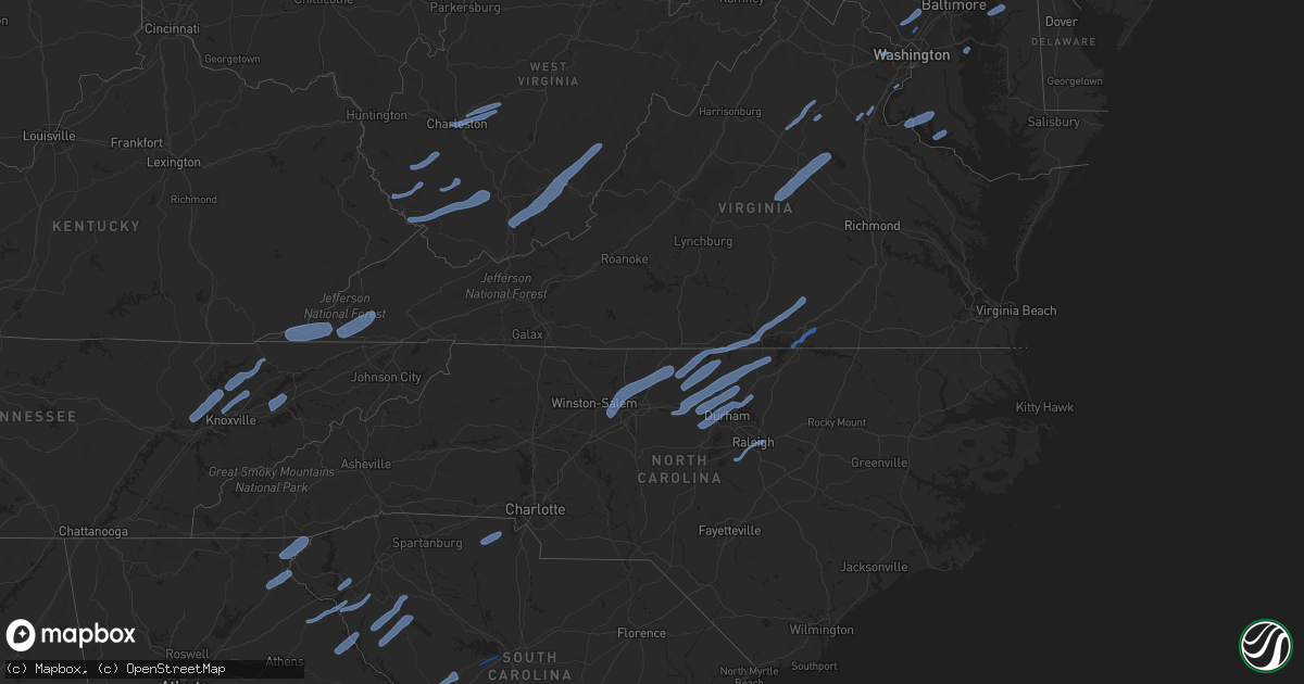
Hail Map in Virginia on October 31, 2019
Get this storm
October 31 map
$229
one time, instant access
Download today. No call, no setup
Keep the $229
Bought the map and want the full workflow? Apply the entire $229 to a subscription within 7 days. None of it is wasted.
Every map, not just this one
This buys you this map. Subscription and you get every map we run, in the markets you choose from a few cities to whole states to nationwide. Plus real-time alerts the moment a storm fires.
Contact data
Name, contact info, occupancy, even credit band for addresses in the footprint. You go from where it hit to who to call.
Become the source they trust
Unlimited branding weather history reports on demand. You already have the documented answer ready for the property owner, and you are the one who showed up with it.
Property data and RoofTrace estimates
Pull up any address you have got, its value and the exact code rules for that jurisdiction, straight from One Click Code. Then RoofTrace estimates the squares, pitch, and roof value, priced the way you price.
Storm reports in Virginia
Virginia
| Date | Description |
|---|---|
| 10/31/20196:48 PM CDT | Confirmed tornado touched down near white house rd in far southwest mecklenburg county. Tornado traveled northeast for approx. 10 minutes before lifting shortly after c |
| 10/31/20196:48 PM CDT | Trees down at pea ridge road at wolftown hood road |
| 10/31/20196:47 PM CDT | Tree down. |
| 10/31/20196:45 PM CDT | Tree down on woodfork rd. Time estimated from radar. |
| 10/31/20196:44 PM CDT | Tree down closing limestone school road |
| 10/31/20196:40 PM CDT | Tree and power lines down on spotswood trail near intersection with goose pond road |
| 10/31/20196:38 PM CDT | Report of 30+ large trees uprooted at a property on falling springs dr. |
| 10/31/20196:35 PM CDT | Tree reported down on hoover road near true blue lane. |
| 10/31/20196:33 PM CDT | Tree down in scottsburg. Timing estimated by radar. |
| 10/31/20196:33 PM CDT | Tree reported down on the 3500 block of leeds manor road. |
| 10/31/20196:31 PM CDT | Trees down at intersection of thoroughfare road at spring branch road |
| 10/31/20196:27 PM CDT | Tree down inlet rd near brandy rd |
| 10/31/20196:25 PM CDT | Tree down in halifax. Timing estimated by radar. |
| 10/31/20196:24 PM CDT | Tree down on mt tabor rd near keeling. |
| 10/31/20196:24 PM CDT | Tree down on orrison road at featherbed lane |
| 10/31/20196:23 PM CDT | Tree down on hoover rd near true blue ln |
| 10/31/20196:21 PM CDT | Trees and wires reported down on jame madison highway near kettle club road. |
| 10/31/20196:19 PM CDT | Tree down on georges mill road at stevens road |
| 10/31/20196:16 PM CDT | Large pine tree down on rt 630 near beahm town rd. |
| 10/31/20196:15 PM CDT | Numerous trees down closing roads in the round hill and purcellville area... Including ketoctin church road |
| 10/31/20196:12 PM CDT | Tree down on midway rd. |
| 10/31/20196:06 PM CDT | Numerous trees down with roads closed in bluemont... Including foggy bottom and hollow oak roads |
| 10/31/20196:04 PM CDT | Ef-0 tornado confirmed. Path length 0.5 miles. Width 25 yards. Max winds 75 mph. |
| 10/31/20195:54 PM CDT | Tree down on zachary taylor road at hume road |
| 10/31/20195:20 PM CDT | Tree down on old valley pike near zion church rd. |
| 10/31/20195:03 PM CDT | Multiple trees down county wide from 4:30 to 5:30pm. |
| 10/31/20194:56 PM CDT | Tree down on ridgeview rd. Time estimated from radar. |
| 10/31/20194:55 PM CDT | Tree down on burks fork rd. |
| 10/31/20194:29 PM CDT | Two trees down in the city of millboro. Timing estimated by radar. |
| 10/31/20194:27 PM CDT | Tree and powerlines down. Timing estimated by radar. |
| 10/31/20194:14 PM CDT | Power lines down near smith mountain lake. Timing estimated by radar. |
| 10/31/20193:57 PM CDT | Tree reported down on the 12000 block of mountain turnpike. |
| 10/31/20193:54 PM CDT | Tree down in the city of hot springs. Timing estimated by radar. |
| 10/31/20193:49 PM CDT | Tree down on shooting creek rd. |
| 10/31/20193:30 PM CDT | Corrects previous tstm wnd dmg report from hillsville. Multiple trees down county wide from 4:30 to 5:30pm. |
| 10/31/20192:00 PM CDT | One tree was blown down on park blvd north of hungry mother state park. |
| 10/31/20191:46 PM CDT | Corrects previous tstm wnd dmg report from 5 nnw marion. One tree was blown down on park blvd north of hungry mother state park. |
| 10/31/20191:41 PM CDT | Large tree down due to high wind gusts blocking entire street. Timing estimated by radar. |
| 10/31/20191:31 PM CDT | Powerlines down. Timing estimated by radar. |
| 10/31/201912:40 PM CDT | Tree down on slate creek road. |
| 10/31/201912:40 PM CDT | Tree down on riverside dr. |
| 10/31/201912:15 PM CDT | Large tree down across hwy 58. |
| 10/31/201912:12 PM CDT | Tree down on spillway lane. |
| 10/31/201912:05 PM CDT | Tree down on intersection of rt. 72 and crab tree hollow. |
| 10/31/201912:00 PM CDT | Tree down. |
| 10/31/201911:58 AM CDT | Tree down on intersection of skeetrock and blowing rock roads. |
| 10/31/201911:35 AM CDT | Tree down. |
| 10/31/201911:30 AM CDT | Tree down. |
| 10/31/201911:15 AM CDT | Numerous trees down across the county. |
| 10/31/201910:50 AM CDT | Trees down. |
| 10/31/20197:26 AM CDT | At 1226 PM EDT, severe thunderstorms were located along a line extending from Lewis Creek to 9 miles southeast of Jonesville, moving northeast at 60 mph. HAZARD...60 mph wind gusts. SOURCE...Radar indicated. IMPACT...Expect damage to roofs, siding, and trees. Locations impacted include... Norton, Wise, Big Stone Gap, Pennington Gap, Clover Fork, Coeburn, Appalachia, Pound, St. Paul and Dryden. |
| 10/31/20197:11 AM CDT | At 1210 PM EDT, severe thunderstorms were located along a line extending from 7 miles southwest of Jonesville to near Sneedville to near Bean Station, moving northeast at 65 mph. HAZARD...60 mph wind gusts. SOURCE...Radar indicated. IMPACT...Expect damage to roofs, siding, and trees. Locations impacted include... Kingsport, Rogersville, Gate City, Sneedville, Surgoinsville, Church Hill, Mount Carmel, Duffield, Clinchport and Treadway. |
| 10/31/20196:33 AM CDT | At 1133 AM EDT, a severe thunderstorm was located 7 miles southwest of New Tazewell, or 10 miles northeast of Maynardville, moving northeast at 55 mph. HAZARD...60 mph wind gusts. SOURCE...Radar indicated. IMPACT...Expect damage to roofs, siding, and trees. Locations impacted include... Sneedville, New Tazewell, Tazewell, Harrogate, Springdale, Lone Mountain, Howard Quarter, Evanston, Ewing and Arthur. |
| 10/31/20194:18 AM CDT | At 918 PM EDT, a severe thunderstorm was located over Alberta, or 7 miles north of Lawrenceville, moving northeast at 60 mph. HAZARD...60 mph wind gusts. SOURCE...Radar indicated. IMPACT...Expect damage to trees and powerlines. This severe thunderstorm will be near, McKenney around 930 PM EDT. Dinwiddie and Dewitt around 935 PM EDT. Carson and Sutherland around 940 PM EDT. Petersburg around 950 PM EDT.Other locations impacted by this severe thunderstorm include Cochran,Addison, Booker, Dolphin, Lumberton, Wharfs Store, Darvills, ChurchRoad, Templeton and Edgerton. |
| 10/31/20194:14 AM CDT | At 914 PM EDT, severe thunderstorms were located along a line extending from 6 miles west of Ebony to near Kittrell, moving northeast at 40 mph. HAZARD...60 mph wind gusts. SOURCE...Radar indicated. IMPACT...Expect damage to roofs, siding, and trees. Locations impacted include... Roanoke Rapids, Warrenton, Norlina, Littleton, Macon, Centerville, Ingleside, Medoc Mountain State Park, Gillburg and Afton. |
| 10/31/20194:08 AM CDT | At 908 PM EDT, a severe thunderstorm was located over Centreville, moving northeast at 50 mph. HAZARD...60 mph wind gusts. SOURCE...Radar indicated. IMPACT...Damaging winds will cause some trees and large branches to fall. This could injure those outdoors, as well as damage homes and vehicles. Roadways may become blocked by downed trees. Localized power outages are possible. Unsecured light objects may become projectiles. Locations impacted include... Centreville, Bethesda, Reston, Annandale, Fairfax, Vienna, Falls Church, Mantua, Pimmit Hills, American Legion Bridge, Mclean, Potomac, North Bethesda, Oakton, Chantilly, Tysons Corner, Wolf Trap, Great Falls, Merrifield and Chevy Chase. |
| 10/31/20193:42 AM CDT | At 840 PM EDT, severe thunderstorms were located along a line extending from near Louisa to near Trenholm, moving east at 30 mph. HAZARD...60 mph wind gusts and penny size hail. SOURCE...Radar indicated. IMPACT...Expect damage to trees and powerlines. Severe thunderstorms will be near, Louisa around 845 PM EDT. Mineral around 855 PM EDT. Goochland around 905 PM EDT. Gum Spring around 910 PM EDT. Oilville around 915 PM EDT. Montpelier and Wyndham around 930 PM EDT.Other locations impacted by these severe thunderstorms includeOrchid, Louisa Airport, Vontay, Maidens, Three Square, Irwin,Johnsons Springs, Gilman, Tabscott and Othma. |
| 10/31/20193:32 AM CDT | At 832 PM EDT, severe thunderstorms were located along a line extending from near Damascus to near Lowes Island, moving northeast at 50 mph. HAZARD...60 mph wind gusts. SOURCE...Radar indicated. IMPACT...Damaging winds will cause some trees and large branches to fall. This could injure those outdoors, as well as damage homes and vehicles. Roadways may become blocked by downed trees. Localized power outages are possible. Unsecured light objects may become projectiles. Locations impacted include... Columbia, Germantown, Rockville, Gaithersburg, Olney, Damascus, Lowes Island, Ellicott City, Aspen Hill, Montgomery Village, Eldersburg, North Potomac, Redland, Mount Airy, Sykesville, Oakland, Rossmoor, Gamber, Scaggsville and Cloverly. |
| 10/31/20193:27 AM CDT | At 827 PM EDT, a severe thunderstorm was located near Orange, moving northeast at 75 mph. HAZARD...60 mph wind gusts. SOURCE...Radar indicated. IMPACT...Damaging winds will cause some trees and large branches to fall. This could injure those outdoors, as well as damage homes and vehicles. Roadways may become blocked by downed trees. Localized power outages are possible. Unsecured light objects may become projectiles. Locations impacted include... Culpeper, Orange, Bealeton, Gordonsville, Opal, Remington, Midland, Elkwood, Stevensburg, Roseville, Brandy Station, Oakpark, Everona, Montpelier Station, Flat Run, Nasons, Winston, Heflin, Madison Mills and Montford. |
| 10/31/20193:17 AM CDT | At 816 PM EDT, a severe thunderstorm was located over Boswells Tavern, or 8 miles west of Louisa, moving northeast at 60 mph. HAZARD...60 mph wind gusts and penny size hail. SOURCE...Radar indicated. IMPACT...Expect damage to trees and powerlines. This severe thunderstorm will remain over mainly rural areas of northwestern Louisa and north central Fluvanna Counties, including the following locations... Zion Crossroads, Waldrop, Vawter Corner, Green Springs and Gordonsville. |
| 10/31/20192:32 AM CDT | At 732 PM EDT, severe thunderstorms were located along a line extending from near Charlottesville to near Phenix, moving east at 45 mph. HAZARD...60 mph wind gusts and penny size hail. SOURCE...Radar indicated. IMPACT...Expect damage to trees and powerlines. Severe thunderstorms will be near, Darlington Heights around 750 PM EDT. Hampden Sydney College, Hampden Sydney and Boswells Tavern around 800 PM EDT. Farmville around 805 PM EDT. Longwood University and Green Bay around 810 PM EDT. Burkeville and Rice around 815 PM EDT.Other locations impacted by these severe thunderstorms includeTuggle, Angola, Three Square, Central Plains, Bremo Bluff, Hawk,Elam, Whiteville, Grays Siding and West View. |
| 10/31/20192:19 AM CDT | At 719 PM EDT, a severe thunderstorm was located 7 miles northeast of Madison, moving northeast at 60 mph. HAZARD...60 mph wind gusts. SOURCE...Radar indicated. This storm has a history of producing tree damage near Oak Park. IMPACT...Damaging winds will cause some trees and large branches to fall. This could injure those outdoors, as well as damage homes and vehicles. Roadways may become blocked by downed trees. Localized power outages are possible. Unsecured light objects may become projectiles. Locations impacted include... Culpeper, Bealeton, Brightwood, Opal, Catalpa, Viewtown, Oakpark, Amissville, Casanova, Jeffersonton, Turnbull, Cardova, Reva, Rixeyville, Fordsville, Leon, Alanthus and Boston. |
| 10/31/20192:06 AM CDT | At 705 PM EDT, severe thunderstorms were located along a line extending from near Riverville to near Blanch, moving northeast at 70 mph. HAZARD...60 mph wind gusts. SOURCE...Radar indicated. IMPACT...Expect damage to roofs, siding, and trees. Locations impacted include... Buckingham... South Boston... Appomattox... Halifax... Brookneal... Keysville... and Charlotte Court House. |
| 10/31/201912:45 AM CDT | At 544 PM EDT, a severe thunderstorm was located 9 miles southeast of Romney, moving northeast at 55 mph. HAZARD...60 mph wind gusts. SOURCE...Radar indicated. IMPACT...Damaging winds will cause some trees and large branches to fall. This could injure those outdoors, as well as damage homes and vehicles. Roadways may become blocked by downed trees. Localized power outages are possible. Unsecured light objects may become projectiles. Locations impacted include... Martinsburg, Greenwood, Inwood, Capon Bridge, Tomahawk, Yellow Spring, High View, Johnsontown, Oakland, Bloomery, Delray, Cross Junction, Arden, Jones Springs, Kirby, Unger, Gore, Augusta, Glengary and Omps. |
| 10/31/201912:45 AM CDT | Powerlines ripped away from house and multiple screens missing from windows. |
| 10/31/201912:25 AM CDT | At 524 PM EDT, a severe thunderstorm was located over Goode, or near Forest, moving northeast at 55 mph. HAZARD...60 mph wind gusts. SOURCE...Radar indicated. IMPACT...Expect damage to roofs, siding, and trees. Locations impacted include... Lynchburg... Bedford... Amherst... Forks Of Buffalo... Clifford... Big Island... and Forest.This includes The following Location The National D-Day Memorial. |
| 10/31/201912:03 AM CDT | At 503 PM EDT, a severe thunderstorm was located near Sydnorsville, moving northeast at 45 mph. HAZARD...60 mph wind gusts. SOURCE...Radar indicated. IMPACT...Expect damage to roofs, siding, and trees. Locations impacted include... Penhook... Western Smith Mountain Lake... Union Hall... Sontag... North Shore... Westlake Corner... and Southern Smith Mountain Lake. |
| 10/31/201912:02 AM CDT | Tree on powerlines on pennsylvania ave. In onley. |
| 10/31/201912:01 AM CDT | Large tree down on lankford hwy. |
| 10/30/201911:58 PM CDT | Numerous power outages due to storm damage in the hickory area of chesapeake. |
| 10/30/201911:58 PM CDT | Trees snapped along dewald rd. In the hickory area of the city of chesapeake. Numerous trees down... Some on houses and on a motor home. The area of damage was about 30 |
| 10/30/201911:55 PM CDT | Nws storm survey confirmed an ef1 tornado in the city of chesapeake. The tornado touched down near benefit rd. And rapidly tracked ene 4.9 miles before lifting prior to |
| 10/30/201911:55 PM CDT | 2200 block of shillelagh closed due to downed powerlines and a large tree blocking the road. |
| 10/30/201911:51 PM CDT | At 451 PM EDT, severe thunderstorms were located along a line extending from near Baywood to near Elkville, moving northeast at 25 mph. HAZARD...60 mph wind gusts. SOURCE...Radar indicated. IMPACT...Expect damage to roofs, siding, and trees. Locations impacted include... Galax... North Wilkesboro... Elkin... Wilkesboro... Sparta... Independence... and Fries. |
| 10/30/201911:41 PM CDT | At 441 PM EDT, severe thunderstorms were located along a line extending from near Monterey to near Burnsville, moving northeast at 60 mph. HAZARD...60 mph wind gusts. SOURCE...Radar indicated. IMPACT...Damaging winds will cause some trees and large branches to fall. This could injure those outdoors, as well as damage homes and vehicles. Roadways may become blocked by downed trees. Localized power outages are possible. Unsecured light objects may become projectiles. Locations impacted include... Franklin, Monterey, Brandywine, Doe Hill, Head Waters, Bolar, Deer Run, Liberty, Circleville, Ruddle, Williamsville, Oak Flat, Vanderpool, Sirons Mill, Hightown, Clover Creek, Mill Gap, Cherry Grove, New Hampden and Harper. |
| 10/30/201911:41 PM CDT | Awos station kngu norfolk nas cham. |
| 10/30/201911:39 PM CDT | Front porch roof damaged at a residence on queenswood dr. In portsmouth. |
| 10/30/201911:36 PM CDT | Mesonet station domv2 dominion terminal. |
| 10/30/201911:31 PM CDT | Tree on a house at michael st. And deerfield blvd. In hampton. |
| 10/30/201911:30 PM CDT | At 429 PM EDT, a severe thunderstorm was located over Claytor Lake State Park, or near Dublin, moving northeast at 60 mph. HAZARD...60 mph wind gusts. SOURCE...Radar indicated. IMPACT...Expect damage to roofs, siding, and trees. Locations impacted include... Blacksburg... Christiansburg... Radford... Hillsville... Pilot... Shawsville... and Allisonia.This includes The following Location Virginia Tech. |
| 10/30/201911:02 PM CDT | At 402 PM EDT, a severe thunderstorm was located near Beartown State Park, or 9 miles southwest of Marlinton, moving northeast at 55 mph. HAZARD...60 mph wind gusts. SOURCE...Radar indicated. IMPACT...Expect damage to roofs, siding, and trees. Locations impacted include... Marlinton, Cass Scenic Railroad, Greenbank, Snowshoe, Durbin, Hillsboro, Dunmore, Arbovale, Bartow, Cranberry Mountain Nature Center, Frost, Boyer, Edray and Buckeye. |
| 10/30/201910:45 PM CDT | At 344 PM EDT, severe thunderstorms were located along a line extending from 6 miles northwest of Elk Park to near Table Rock, moving northeast at 50 mph. HAZARD...60 mph wind gusts. SOURCE...Radar indicated. IMPACT...Expect damage to roofs, siding, and trees. Locations impacted include... Boone... North Wilkesboro... Wilkesboro... Sparta... Jefferson... West Jefferson... and Blowing Rock.This includes The following Location Appalachian State University. |
| 10/30/201910:44 PM CDT | Corrects previous tstm wnd dmg report from 2 wnw dendron. Large trees uprooted at a residence near dendron. |
| 10/30/201910:42 PM CDT | Several trees down in spring hill near wakefield. |
| 10/30/201910:41 PM CDT | At 341 PM EDT, severe thunderstorms were located along a line extending from near Parsons to near Snowshoe, moving east at 45 mph. HAZARD...60 mph wind gusts. SOURCE...Radar indicated. IMPACT...Expect damage to roofs, siding, and trees. Locations impacted include... Elkins, Mill Creek, Dailey, Snowshoe, Mingo, Beverly, Durbin, Huttonsville, Montrose, Harman, Arbovale, Cheat Bridge, Dryfork, Bartow, Glady, Boyer, Bowden, Kerens and Valley Head.This includes Route 33 between mile markers 34 and 35. |
| 10/30/201910:39 PM CDT | Large trees uprooted at a residence near dendron. |
| 10/30/20199:54 PM CDT | Around a dozen downed trees in the dahlgren area. |
| 10/30/20199:52 PM CDT | Downed tree near owens drive and gambo creek road. |
| 10/30/20199:48 PM CDT | Downed tree near ridge road and lakeview drive. |
| 10/30/20199:45 PM CDT | At 242 PM EDT, severe thunderstorms were located along a line extending from Camden On Gauley to near Marion, moving northeast at 70 mph. HAZARD...60 mph wind gusts. SOURCE...Radar indicated. IMPACT...Expect damage to roofs, siding, and trees. Locations impacted include... Bluefield... Wytheville... Bland... Princeton... Marion... Tazewell... and Lewisburg.This includes The following Locations The West Virginia StateFairgrounds and Mercer County Airport. |
| 10/30/20199:43 PM CDT | At 242 PM EDT, severe thunderstorms were located along a line extending from 7 miles southwest of Salem to 6 miles north of Quinwood, moving northeast at 60 mph. HAZARD...60 mph wind gusts. SOURCE...Radar indicated. IMPACT...Expect damage to roofs, siding, and trees. Locations impacted include... Clarksburg, Elkins, Buckhannon, Grafton, Weston, Philippi, Richwood, Sutton, Audra State Park, Webster Springs, Cass Scenic Railroad, Greenbank, Bridgeport, Shinnston, Belington, Stonewood, Nutter Fort, Gassaway, Lumberport and Addison (Webster Springs).This includes the following highways... Interstate 79 between mile markers 55 and 128. Route 50 in West Virginia between mile markers 70 and 82. Route 19 between mile markers 51 and 68. Route 33 between mile markers 1 and 35. |
| 10/30/20199:24 PM CDT | Tree reported down in new post |
| 10/30/20199:17 PM CDT | Tree down on va-236 at high pl and lafayette park drive |
| 10/30/20199:17 PM CDT | A tree was down across the road along cabin road and stonewall manor drive. |
| 10/30/20199:15 PM CDT | Numerous trees down in the thornburg area |
| 10/30/20199:13 PM CDT | Several trees down in partlow |
| 10/30/20199:09 PM CDT | Four trees down along ebenezer church road. |
| 10/30/20199:07 PM CDT | Tree down along brock road |
| 10/30/20199:01 PM CDT | Tree down on purcell road near kahns road |
| 10/30/20198:59 PM CDT | Numerous trees down along route 17. |
| 10/30/20198:57 PM CDT | Trees down along route 3 in chancellorsville |
| 10/30/20198:46 PM CDT | Tree down in the 400 block of westover parkway |
| 10/30/20198:44 PM CDT | Tree down in the 34400 block of constitution highway |
| 10/30/20198:35 PM CDT | Tree down in the 26100 block of orange springs road |
| 10/30/20198:33 PM CDT | Tree down on cabin road at stonewall manor drive |
| 10/30/20198:32 PM CDT | At 130 PM EDT, severe thunderstorms were located along a line extending from near Oceana to near Bristol Va, moving northeast at 55 mph. HAZARD...60 mph wind gusts. SOURCE...Radar indicated. IMPACT...Expect damage to roofs, siding, and trees. Locations impacted include... Bluefield... Wytheville... Bland... Princeton... Marion... Richlands... and Tazewell.This includes The following Location Mercer County Airport. |
| 10/30/20198:31 PM CDT | Tree down at intersection of va-123 and potomac school road and georgetown pike |
| 10/30/20198:26 PM CDT | Trees down along courthouse road. |
| 10/30/20198:25 PM CDT | Tree down on fern oak court at hornet lane |
| 10/30/20198:24 PM CDT | At 123 PM EDT, severe thunderstorms were located along a line extending from 6 miles west of Van to 7 miles east of Grundy, moving northeast at 60 mph. HAZARD...60 mph wind gusts. SOURCE...Radar indicated. IMPACT...Expect damage to roofs, siding, and trees. Locations impacted include... Welch, Pineville, Mullens, Oceana, Gary, Man, Northfork, Hanover, R.d. Bailey Lake, Gilbert Creek, Bald Knob, Mallory, Amherstdale-Robinette, Twin Falls State Park, Wharton, Gilbert, Davy, Bradshaw, Iaeger and Keystone. |
| 10/30/20198:23 PM CDT | Tree down in the 17500 block of mountain track road |
| 10/30/20198:15 PM CDT | Tree down on riviera drive at corsica street |
| 10/30/20198:15 PM CDT | Tree down on hill road at ivy lane |
| 10/30/20198:15 PM CDT | Tree down on woodrow street at stryker avenue |
| 10/30/20198:14 PM CDT | A few trees and powerlines down in brunswick county. |
| 10/30/20198:11 PM CDT | Tree down on rifle ridge road. Tree also down on adel road at samaga drive |
| 10/30/20198:07 PM CDT | Tree down in the 8400 block of briarmont lane |
| 10/30/20198:05 PM CDT | Tree down on leland road near centreville road |
| 10/30/20197:52 PM CDT | Tree reported down on the 8100 block of burwell road. |
| 10/30/20197:52 PM CDT | Tree reported down on the 2700 block of dumfries road. |
| 10/30/20197:52 PM CDT | Tree reported down on 1400 block of swoego road. |
| 10/30/20197:52 PM CDT | Tree down at intersection of pageland lane and lee highway |
| 10/30/20197:45 PM CDT | Trees down throughout louisa county. |
| 10/30/20197:45 PM CDT | A few trees down throughout goochland county. |
| 10/30/20197:44 PM CDT | Tree reported down on the 15000 block of inlet road. |
| 10/30/20197:39 PM CDT | Tree reported down on the 11000 block of rougues road. |
| 10/30/20197:39 PM CDT | Multiple trees reported down on eleyes ford road. |
| 10/30/20197:33 PM CDT | Tree down in the 28000 block of raccoon ford road |
| 10/30/20197:33 PM CDT | Tree down on waterfall road at duck lane |
| 10/30/20197:33 PM CDT | Tree reported down messick road and germantown road. |
| 10/30/20197:33 PM CDT | Tree reported down on the 5500 block of germantown road. |
| 10/30/20197:31 PM CDT | Tree down at constitution highway and ivy lane |
| 10/30/20197:31 PM CDT | Tree down in the 11300 block of zachary taylor highway |
| 10/30/20197:27 PM CDT | Tree down at lahore road and gum tree road |
| 10/30/20197:25 PM CDT | Tree reported down on the 17000 block of carrico mills road. |
| 10/30/20197:21 PM CDT | Tree reported down on stevensburg road near greens corner road. |
| 10/30/20197:21 PM CDT | Tree reported down on the 3600 block of zulla road. |
| 10/30/20197:17 PM CDT | Tree reported down on the 20000 block of mount pony road. |
| 10/30/20197:17 PM CDT | Multiple trees reported down on zachary taylor road. |
| 10/30/20197:15 PM CDT | Tree reported down on the 9600 block of crest hill road. |
| 10/30/20197:15 PM CDT | Trees down throughout mecklenburg county. Time estimated from radar. |
| 10/30/20197:13 PM CDT | Trees and wires down on stevens loop road at home again drive |
| 10/30/20197:13 PM CDT | Tree down at little zion road and tomahawk creek road |
| 10/30/20197:11 PM CDT | Tree down at litchfield drive at old gordonsville road |
| 10/30/20197:11 PM CDT | Tree down in the 14100 block of old gordonsville road |
| 10/30/20197:11 PM CDT | Multiple trees reported down on algonquin trail. |
| 10/30/20197:10 PM CDT | Multiple trees down throughout the county. Time estimated from radar. |
| 10/30/20197:09 PM CDT | Tree down at spicers mill road and miller road |
| 10/30/20197:00 PM CDT | Tree down on a residence on rockfish run road. |
| 10/30/20197:00 PM CDT | Tree down. Time estimated from radar. |
| 10/30/20197:00 PM CDT | Tree down on hwy 15. Time estimated from radar. |
| 10/30/20197:00 PM CDT | Tree down. |
All States Impacted by Hail Map on October 31, 2019
Cities Impacted by Hail Map on October 31, 2019
- La Crosse, VA
- Boydton, VA
- Bracey, VA
- Brodnax, VA
- Culpeper, VA
- Madison, VA
- Aroda, VA
- Brightwood, VA
- Reva, VA
- Pratts, VA
- Rochelle, VA
- Oakpark, VA
- Mitchells, VA
- Louisa, VA
- Scottsville, VA
- Mineral, VA
- Troy, VA
- Bremo Bluff, VA
- Fork Union, VA
- Kents Store, VA
- Palmyra, VA
- Fredericksburg, VA
- Stafford, VA
- Lorton, VA
- Annapolis, MD
- Lenore, WV
- Williamson, WV
- Logan, WV
- Pecks Mill, WV
- Delbarton, WV
- Chapmanville, WV
- Holden, WV
- Foster, WV
- Julian, WV
- Danville, WV
- Harts, WV
- Big Creek, WV
- Bim, WV
- Wharton, WV
- Twilight, WV
- Gilbert, WV
- Ravencliff, WV
- Glen Rogers, WV
- Fairdale, WV
- Glen Daniel, WV
- Matewan, WV
- Coal Mountain, WV
- Simon, WV
- Surveyor, WV
- Maben, WV
- Baisden, WV
- Saxon, WV
- Wharncliffe, WV
- Beckley, WV
- Lester, WV
- Bolt, WV
- Glen Fork, WV
- Jesse, WV
- Oceana, WV
- Verner, WV
- Matheny, WV
- Arnett, WV
- Cyclone, WV
- Clear Fork, WV
- Slab Fork, WV
- Procious, WV
- Elkview, WV
- Bomont, WV
- Charleston, WV
- Clendenin, WV
- South Charleston, WV
- Crawley, WV
- Pence Springs, WV
- Renick, WV
- Sandstone, WV
- Green Sulphur Springs, WV
- Hinton, WV
- Jumping Branch, WV
- Nimitz, WV
- Williamsburg, WV
- Buckeye, WV
- Grassy Meadows, WV
- Asbury, WV
- Maxwelton, WV
- Hillsboro, WV
- Lewisburg, WV
- Flat Top, WV
- Talcott, WV
- Smoot, WV
- Alderson, WV
- Waterloo, SC
- Abbeville, SC
- Hodges, SC
- Greenwood, SC
- Clayton, GA
- Tiger, GA
- North Augusta, SC
- Grovetown, GA
- Clarks Hill, SC
- Ridge Spring, SC
- Johnston, SC
- Evans, GA
- Augusta, GA
- Trenton, SC
- Monetta, SC
- Harlem, GA
- Graniteville, SC
- Aiken, SC
- Beech Island, SC
- Gibson, GA
- Warrenville, SC
- Avera, GA
- Wrens, GA
- Matthews, GA
- Hephzibah, GA
- Stapleton, GA
- Gloverville, SC
- Blythe, GA
- Keysville, GA
- Bartow, GA
- Wadley, GA
- Waynesboro, GA
- Davisboro, GA
- New Ellenton, SC
- Jackson, SC
- Louisville, GA
- Sharon, SC
- Smyrna, SC
- Clover, SC
- York, SC
- Gilbert, SC
- Lexington, SC
- Reidsville, NC
- Ruffin, NC
- Kernersville, NC
- Colfax, NC
- High Point, NC
- Stokesdale, NC
- Yanceyville, NC
- Greensboro, NC
- Browns Summit, NC
- Summerfield, NC
- Pelham, NC
- Oak Ridge, NC
- Alton, VA
- Virgilina, VA
- Skipwith, VA
- Semora, NC
- Elon, NC
- South Hill, VA
- Milton, NC
- Baskerville, VA
- Kenbridge, VA
- Clarksville, VA
- Nelson, VA
- Roxboro, NC
- Blanch, NC
- Chase City, VA
- Buffalo Junction, VA
- Leasburg, NC
- Prospect Hill, NC
- Mebane, NC
- Hurdle Mills, NC
- Burlington, NC
- Hillsborough, NC
- Cedar Grove, NC
- Henderson, NC
- Graham, NC
- Oxford, NC
- Timberlake, NC
- Haw River, NC
- Rougemont, NC
- Efland, NC
- Bahama, NC
- Stem, NC
- Durham, NC
- Creedmoor, NC
- Butner, NC
- Carrboro, NC
- Chapel Hill, NC
- Raleigh, NC
- Knightdale, NC
- Apex, NC
- Holly Springs, NC
- Fuquay Varina, NC
- Clarkesville, GA
- Demorest, GA
- Mount Airy, GA
- Toccoa, GA
- Long Creek, SC
- Westminster, SC
- Anderson, SC
- Pendleton, SC
- Bowersville, GA
- Canon, GA
- Royston, GA
- Starr, SC
- Hartwell, GA
- Laurens, SC
- Donalds, SC
- Due West, SC
- Iva, SC
- Ware Shoals, SC
- Belton, SC
- Elberton, GA
- Hockessin, DE
- Gladwyne, PA
- Kennett Square, PA
- Wilmington, DE
- Bridgeport, PA
- Newtown Square, PA
- Chalfont, PA
- Paoli, PA
- Blue Bell, PA
- Philadelphia, PA
- Oreland, PA
- Villanova, PA
- Willow Grove, PA
- Berwyn, PA
- Horsham, PA
- Dresher, PA
- Montgomeryville, PA
- Spring House, PA
- Landenberg, PA
- Conshohocken, PA
- Media, PA
- Lafayette Hill, PA
- Newtown, PA
- Hatboro, PA
- Richboro, PA
- Malvern, PA
- Thornton, PA
- Flourtown, PA
- Huntingdon Valley, PA
- King Of Prussia, PA
- Devon, PA
- Avondale, PA
- Toughkenamon, PA
- Southampton, PA
- Doylestown, PA
- West Chester, PA
- Gwynedd, PA
- Cheyney, PA
- Bryn Mawr, PA
- Glen Mills, PA
- Warminster, PA
- Norristown, PA
- Ambler, PA
- North Wales, PA
- Jamison, PA
- Chadds Ford, PA
- Glenside, PA
- Furlong, PA
- Plymouth Meeting, PA
- Wayne, PA
- Warrington, PA
- Abington, PA
- Fort Washington, PA
- Silver Spring, MD
- Oakton, VA
- Vienna, VA
- Worton, MD
- Chestertown, MD
- Faulkner, MD
- Mechanicsville, MD
- Newburg, MD
- King George, VA
- Charlotte Hall, MD
- Dahlgren, VA
- Coltons Point, MD
- Leonardtown, MD
- Bushwood, MD
- Abell, MD
- Avenue, MD
- Brinklow, MD
- Ellicott City, MD
- Brookeville, MD
- Olney, MD
- Highland, MD
- Clarksville, MD
- Rockville, MD
- Dayton, MD
- Sandy Spring, MD
- Derwood, MD
- Norris, TN
- Heiskell, TN
- Oak Ridge, TN
- Clinton, TN
- Andersonville, TN
- Powell, TN
- Corryton, TN
- Luttrell, TN
- Blaine, TN
- Knoxville, TN
- Maynardville, TN
- Sharps Chapel, TN
- Tazewell, TN
- New Tazewell, TN
- Dryden, VA
- Duffield, VA
- Blackwater, VA
- Jonesville, VA
- Rose Hill, VA
- Pennington Gap, VA
- Gate City, VA
- Coeburn, VA
- Nickelsville, VA
- Fort Blackmore, VA
- Dungannon, VA
- Talbott, TN
- Jefferson City, TN
- New Market, TN
- Dandridge, TN
- Morristown, TN


