Hail Map in Maryland on October 31, 2019
Get this storm
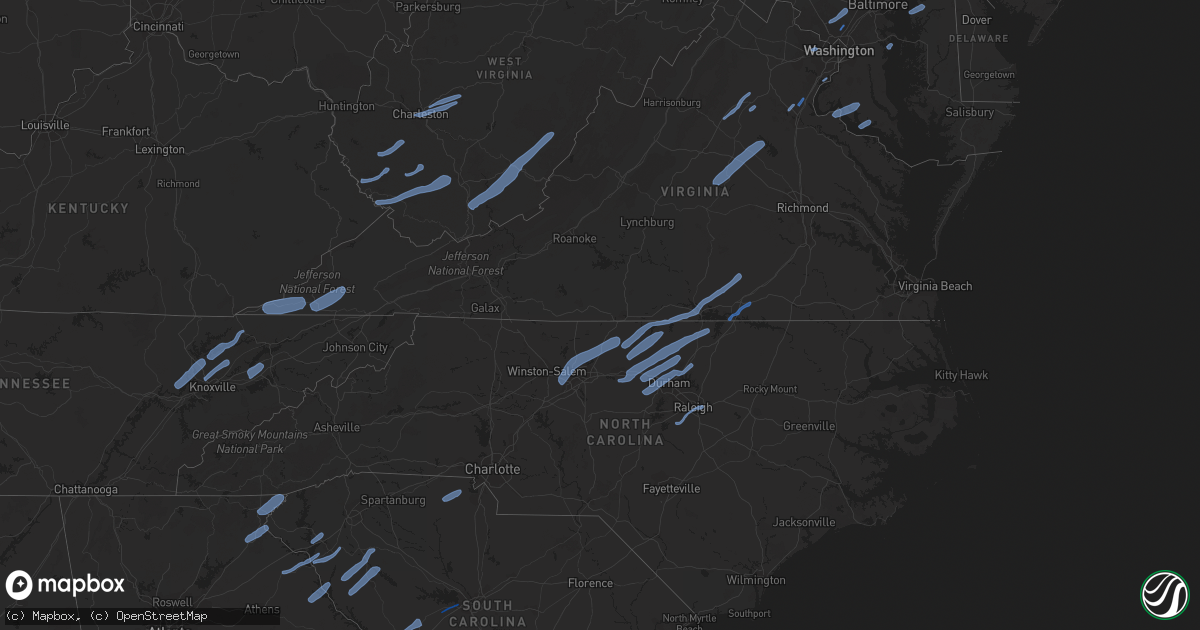
October 31 map
$229
one time, instant access
Download today. No call, no setup
Keep the $229
Bought the map and want the full workflow? Apply the entire $229 to a subscription within 7 days. None of it is wasted.
Every map, not just this one
This buys you this map. Subscription and you get every map we run, in the markets you choose from a few cities to whole states to nationwide. Plus real-time alerts the moment a storm fires.
Contact data
Name, contact info, occupancy, even credit band for addresses in the footprint. You go from where it hit to who to call.
Become the source they trust
Unlimited branding weather history reports on demand. You already have the documented answer ready for the property owner, and you are the one who showed up with it.
Property data and RoofTrace estimates
Pull up any address you have got, its value and the exact code rules for that jurisdiction, straight from One Click Code. Then RoofTrace estimates the squares, pitch, and roof value, priced the way you price.
Storm reports in Maryland
Maryland
| Date | Description |
|---|---|
| 10/31/20196:28 AM CDT | At 1128 PM EDT, severe thunderstorms were located along a line extending from near Saint Georges to near St. Michaels, moving northeast at 65 mph. HAZARD...60 mph wind gusts. SOURCE...Radar indicated. IMPACT...Damage to roofs, siding, trees, and power lines is possible. Locations impacted include... Dover, Middletown, Smyrna, Milford, Harrington, Camden, Clayton, Cheswold, Bowers, Woodside, Viola, Hartly, Rising Sun-Lebanon, Woodland Beach, Hazlettville, Port Penn, Delaney Corner, Dover Base Housing, Dover Speedway and Sandtown. |
| 10/31/20196:23 AM CDT | At 1123 PM EDT, a severe thunderstorm was located over Breezy Point, moving east at 55 mph. HAZARD...60 mph wind gusts. SOURCE...Radar indicated. IMPACT...Damaging winds will cause some trees and large branches to fall. This could injure those outdoors, as well as damage homes and vehicles. Roadways may become blocked by downed trees. Localized power outages are possible. Unsecured light objects may become projectiles. Locations impacted include... Chesapeake Beach, Prince Frederick, Breezy Point, Dunkirk, Huntingtown, Owings, Barstow, Mount Harmony, Sunderland and Dares Beach. |
| 10/31/20196:22 AM CDT | At 1122 PM EDT, severe thunderstorms were located along a line extending from near Leonardtown to near Saint Clements Bay, moving northeast at 60 mph. HAZARD...60 mph wind gusts. SOURCE...Radar indicated. A mesonet at Cobb Point gusted over 60 MPH. IMPACT...Damaging winds will cause some trees and large branches to fall. This could injure those outdoors, as well as damage homes and vehicles. Roadways may become blocked by downed trees. Localized power outages are possible. Unsecured light objects may become projectiles. Locations impacted include... Lexington Park, Leonardtown, Piney Point, Tall Timbers, Saint Inigoes Creek, Saint Marys City, Saint George Island, Saint Clements Bay, Saint Marys River, White Point Beach, Wicomico River, California, Patuxent River Naval Air Station, Bushwood, Abell, Valley Lee, Scotland, Great Mills, Avenue and Drayden. |
| 10/31/20196:15 AM CDT | At 1114 PM EDT, severe thunderstorms were located along a line extending from Riegelsville to Newark, moving northeast at 60 mph. HAZARD...60 mph wind gusts. SOURCE...Radar indicated. IMPACT...Damage to roofs, siding, trees, and power lines is possible. Locations impacted include... Philadelphia, Trenton, Camden, Wilmington, Newark, West Chester, Bensalem, Ewing, Norristown, Chester, Deptford, West Deptford, Phoenixville, Lansdale, West Norriton, East Norriton, Pennsville, Bellmawr, Yeadon and Westtown.This includes the following highways... Interstate 295 in New Jersey between mile markers 0 and 26. Interstate 95 in Pennsylvania between mile markers 0 and 40. New Jersey Turnpike between exits 1 and 2. Interstate 95 in Delaware between mile markers 1 and 23. |
| 10/31/20196:10 AM CDT | At 1110 PM EDT, a severe thunderstorm was located 7 miles southwest of Golden Beach, or 9 miles southwest of Sheridan Point, moving east at 50 mph. HAZARD...60 mph wind gusts. SOURCE...Radar indicated. IMPACT...Damaging winds will cause some trees and large branches to fall. This could injure those outdoors, as well as damage homes and vehicles. Roadways may become blocked by downed trees. Localized power outages are possible. Unsecured light objects may become projectiles. Locations impacted include... Chesapeake Ranch Estates, Leonardtown, Prince Frederick, Greenwell State Park, Hallowing Point, Saint Leonard Creek, Town Creek, Cuckold Creek, Sheridan Point, Calvert Cliffs, Port Tobacco River, Flag Harbor, Popes Creek, California, Golden Beach, Lusby, Hollywood, Saint Leonard, Wicomico and Drum Point. |
| 10/31/20195:56 AM CDT | At 1056 PM EDT, a severe thunderstorm was located near La Plata, moving east at 55 mph. HAZARD...60 mph wind gusts. SOURCE...Radar indicated. IMPACT...Damaging winds will cause some trees and large branches to fall. This could injure those outdoors, as well as damage homes and vehicles. Roadways may become blocked by downed trees. Localized power outages are possible. Unsecured light objects may become projectiles. Locations impacted include... Waldorf, La Plata, Saint Charles, Hughesville, Bryantown, Dentsville and Bel Alton. |
| 10/31/20195:47 AM CDT | At 1047 PM EDT, severe thunderstorms were located along a line extending from near Aberdeen to near Waldorf, moving northeast at 65 mph. HAZARD...60 mph wind gusts. SOURCE...Radar indicated. IMPACT...Damage to roofs, siding, trees, and power lines is possible. Locations impacted include... Easton, Centerville, Talbot, Chestertown, Denton, Centreville, Romancoke, Federalsburg, Greensboro, Oakland, Ridgely, Rock Hall, Trappe, St. Michaels, Church Hill, Preston, Cecilton, Oxford, Millington and Sudlersville. |
| 10/31/20195:25 AM CDT | At 1025 PM EDT, severe thunderstorms were located along a line extending from near New Morgan to Wakefield, moving northeast at 60 mph. HAZARD...70 mph wind gusts. SOURCE...Radar indicated. IMPACT...Expect considerable tree damage. Damage is likely to mobile homes, roofs, and outbuildings. Locations impacted include... Paradise, Quarryville, Gap, Wakefield, Churchtown, Intercourse, Christiana, Georgetown, Goodville, Kirkwood, Little Britain, Buck, White Horse and Peach Bottom.This includes The Pennsylvania Turnpike from mile markers 293 to 295. |
| 10/31/20195:23 AM CDT | At 1023 PM EDT, severe thunderstorms were located along a line extending from East Greenville to near Aberdeen, moving northeast at 65 mph. HAZARD...60 mph wind gusts. SOURCE...Radar indicated. IMPACT...Damage to roofs, siding, trees, and power lines is possible. Locations impacted include... West Chester, Elkton, Calvert, Norristown, Pottstown, Phoenixville, Lansdale, West Norriton, East Norriton, Coatesville, Westtown, Quakertown, Perkasie, Doylestown, Downingtown, Conshohocken, Souderton, Bedminster, Ambler and Kennett Square.This includes the following highways... Interstate 95 in Maryland between mile markers 91 and 109. Interstate 95 in Delaware near mile marker 0. |
| 10/31/20195:14 AM CDT | At 1013 PM EDT, severe thunderstorms were located along a line extending from near Delta to White Marsh, moving northeast at 65 mph. HAZARD...60 mph wind gusts. SOURCE...Radar indicated. IMPACT...Damaging winds will cause some trees and large branches to fall. This could injure those outdoors, as well as damage homes and vehicles. Roadways may become blocked by downed trees. Localized power outages are possible. Unsecured light objects may become projectiles. Locations impacted include... Middle River, Aberdeen, Havre De Grace, Aberdeen Proving Ground, Bel Air South, Bel Air North, Perry Hall, Rosedale, Rossville, White Marsh, Fallston, Bowleys Quarters, Riverside, Kingsville, Pleasant Hills, Jarrettsville, Perryman, Edgewood, Joppatowne and Pylesville. |
| 10/31/20194:35 AM CDT | At 934 PM EDT, severe thunderstorms were located along a line extending from New Holland to Towson, moving northeast at 50 mph. HAZARD...60 mph wind gusts. SOURCE...Radar indicated. IMPACT...Damage to roofs, siding, trees, and power lines is possible. Locations impacted include... Reading, Calvert, Pottstown, Coatesville, Wyomissing, Downingtown, Birdsboro, Oxford, Kutztown, Royersford, Fleetwood, Laureldale, Parkesburg, East Greenville, West Grove, Rising Sun, Topton, Honey Brook, Schwenksville and Elverson.This includes Interstate 95 in Maryland between mile markers 91 and98. |
| 10/31/20194:24 AM CDT | At 923 PM EDT, a severe thunderstorm was located over Stafford, moving northeast at 60 mph. HAZARD...60 mph wind gusts. SOURCE...Emergency management has reported numerous trees down in Spotsylvania County associated with this storm. IMPACT...Damaging winds will cause some trees and large branches to fall. This could injure those outdoors, as well as damage homes and vehicles. Roadways may become blocked by downed trees. Localized power outages are possible. Unsecured light objects may become projectiles. Locations impacted include... Stafford, Dale City, Fredericksburg, Quantico, Lake Ridge, Montclair, Triangle, Dumfries, Cherry Hill, Independent Hill, Falmouth, Roseville, Garrisonville, Arkendale, Spring Valley, Ramoth, Aquia and Glendie. |
| 10/31/20192:08 AM CDT | At 706 PM EDT, severe thunderstorms were located along a line extending from 7 miles northwest of Millersburg to Newport to near Duncannon to Pine Grove Furnace to near Mont Alto, moving northeast at 65 mph. HAZARD...70 mph wind gusts. SOURCE...Radar indicated. IMPACT...Expect considerable tree damage. Damage is likely to mobile homes, roofs, and outbuildings. Locations impacted include... Harrisburg, York, Carlisle, Lower Allen, Hanover, Hershey, Colonial Park, Weigelstown, Waynesboro, Progress, Mechanicsburg, Middletown, Camp Hill, Gettysburg, Shamokin, Palmyra, New Cumberland, Parkville, Linglestown and Enola.This includes the following Interstates... The Pennsylvania Turnpike from mile markers 222 to 259. Interstate 78 from mile markers 0 to 4. Interstate 81 between mile markers 42 and 102...and from mile markers 104 to 112. Interstate 83 from mile markers 21 to 50. Interstate 283 from mile markers 0 to 2. |
| 10/31/20191:46 AM CDT | At 645 PM EDT, a severe thunderstorm was located near Inwood, or 9 miles northeast of Winchester, moving northeast at 55 mph. HAZARD...60 mph wind gusts. SOURCE...Radar indicated. IMPACT...Damaging winds will cause some trees and large branches to fall. This could injure those outdoors, as well as damage homes and vehicles. Roadways may become blocked by downed trees. Localized power outages are possible. Unsecured light objects may become projectiles. Locations impacted include... Frederick, Hagerstown, Winchester, Martinsburg, Charles Town, Shepherdstown, Millwood Pike, Robinwood, Walkersville, Ranson, Boonsboro, Inwood, Braddock Heights, Mount Aetna, Mount Lena, San Mar, Harpers Ferry, Corporation Of Ranson, Kearneysville and Clover Hill. |
| 10/31/20191:27 AM CDT | At 625 PM EDT, severe thunderstorms were located along a line extending from near Big Spring State Park to near Roxbury to near Upper Strasburg to Marion to 8 miles east of Hancock, moving northeast at 50 mph. HAZARD...70 mph wind gusts. SOURCE...Radar indicated. IMPACT...Expect localized considerable tree damage. Damage is likely to mobile homes, roofs, and outbuildings. Locations impacted include... Chambersburg, Carlisle, Waynesboro, Shippensburg, Greencastle, Guilford, Plainfield, St. Thomas, Schlusser, Fayetteville, Wayne Heights, Mount Holly Springs, Mont Alto, Newport, Mercersburg, Duncannon, Scotland, Newville, New Bloomfield and Marion.This includes the following Interstates... The Pennsylvania Turnpike from mile markers 194 to 229. Interstate 81 from mile markers 1 to 56. |
| 10/31/20191:15 AM CDT | Trees snapped at links at lighthouse sound golf course. Damage was consistent with straight line wind. |
| 10/31/201912:42 AM CDT | At 541 PM EDT, severe thunderstorms were located along a line extending from near Big Cove Tannery to near Hancock to near Greenwood, moving northeast at 55 mph. HAZARD...60 mph wind gusts. SOURCE...Radar indicated. IMPACT...Expect damage to trees, roofs, and siding. Locations impacted include... Chambersburg, Waynesboro, Shippensburg, Greencastle, Guilford, St. Thomas, Fayetteville, Warfordsburg, Wayne Heights, Mont Alto, Mercersburg, Scotland, McConnellsburg, Rouzerville, Marion, Fort Loudon, Big Cove Tannery, Needmore, Claylick and Willow Hill.This includes the following Interstates... Interstate 70 from mile markers 167 to 170. The Pennsylvania Turnpike from mile markers 188 to 201. Interstate 81 from mile markers 1 to 25. |
| 10/31/201912:20 AM CDT | Damage at an rv park along st. Martins neck rd. |
| 10/31/201912:13 AM CDT | Roof damage at kelly foods corporation. |
| 10/31/201912:12 AM CDT | Trees down at atlantic general hospital. |
| 10/31/201912:01 AM CDT | Trees and powerlines down in around willards. |
| 10/31/201912:01 AM CDT | Trees and powerlines down around powellville. |
| 10/30/201911:56 PM CDT | At 456 PM EDT, a severe thunderstorm was located over Romney, moving northeast at 55 mph. HAZARD...60 mph wind gusts. SOURCE...Radar indicated. IMPACT...Damaging winds will cause some trees and large branches to fall. This could injure those outdoors, as well as damage homes and vehicles. Roadways may become blocked by downed trees. Localized power outages are possible. Unsecured light objects may become projectiles. Locations impacted include... Romney, Paw Paw, Greenwood, Berkeley Springs, Springfield, Great Cacapon, Hedgesville, Green Spring, Oldtown, Little Orleans, Johnsons Mill, Tomahawk, Shanks, Johnsontown, Valley View, Spohrs Crossroads, Fishers Bridge, Oakland, Rock Gap and Bloomery. |
| 10/30/201911:54 PM CDT | Downed power lines near the intersection of spring branch road and greensboro road. Time estimated from radar. |
| 10/30/201911:47 PM CDT | Several reports of downed trees in the area. Time estimated from radar. |
| 10/30/201911:44 PM CDT | Trees and powerlines down in salisbury. |
| 10/30/201911:44 PM CDT | Transformer fire in fruitland. |
| 10/30/201911:35 PM CDT | Powerlines down along allen road. |
| 10/30/201911:11 PM CDT | Downed utility near the intersection of state highway 802 and romancoke road. Time estimated from radar. |
| 10/30/201911:10 PM CDT | At 409 PM EDT, severe thunderstorms were located along a line extending from near Davis to 10 miles southeast of Thomas, moving northeast at 60 mph. HAZARD...60 mph wind gusts. SOURCE...Radar indicated. IMPACT...Damaging winds will cause some trees and large branches to fall. This could injure those outdoors, as well as damage homes and vehicles. Roadways may become blocked by downed trees. Localized power outages are possible. Unsecured light objects may become projectiles. Locations impacted include... Keyser, Moorefield, Romney, Bayard, Piedmont, Elk Garden, Kitzmiller, Burlington, Luke, Gorman, Russelldale, Bean Settlement, Arthur, Beechwood, Hartmansville, New Creek, Seymourville, Lahmansville, Reeses Mill and Medley. |
| 10/30/201911:06 PM CDT | Tolchester beach nos gauge. |
| 10/30/201910:59 PM CDT | Tree down in the 17300 block of whitaker road |
| 10/30/201910:54 PM CDT | Downed power lines near the intersection of spring branch road and greensboro road. Time estimated from radar. |
| 10/30/201910:47 PM CDT | Several reports of downed trees in the area. Time estimated from radar. |
| 10/30/201910:46 PM CDT | Tree down in the 46600 block of frogs marsh road |
| 10/30/201910:42 PM CDT | Tree down in the 100 block of leason cove drive |
| 10/30/201910:38 PM CDT | Trees down in the 21100 block of tri community way and 20600 block of vintage lane in lexington park |
| 10/30/201910:37 PM CDT | Tree down in the 22300 block of golden road drive |
| 10/30/201910:34 PM CDT | Tree down in the 44400 block of boxwood drive |
| 10/30/201910:29 PM CDT | Tree down at intersection of saint leonard road and west shores boulevard |
| 10/30/201910:27 PM CDT | Tree down in the 300 block of shannon avenue |
| 10/30/201910:25 PM CDT | Tree down at willows road and bayside road |
| 10/30/201910:25 PM CDT | Tree down in the 24400 block of mcintosh road |
| 10/30/201910:23 PM CDT | Tree damage at the intersection of clay hammond road and oliver drive |
| 10/30/201910:22 PM CDT | Tree down in the 20900 block of golden thompson road |
| 10/30/201910:16 PM CDT | A local report indicates 62 MPH wind near 2 SE COBB ISLAND |
| 10/30/201910:15 PM CDT | Large tree uprooted. Another large tree down. Tin roof torn off shed. Skirting partially ripped off trailer. Boat blown off boat trailer. |
| 10/30/201910:11 PM CDT | Downed utility near the intersection of state highway 802 and romancoke road. Time estimated from radar. |
| 10/30/201910:10 PM CDT | Tree down at intersection of ward road and haven road |
| 10/30/201910:06 PM CDT | Tolchester beach nos gauge. |
| 10/30/201910:04 PM CDT | A local report indicates 58 MPH wind near SWAN POINT |
| 10/30/201910:00 PM CDT | Downed treen near the poplar hill road and breconridge drive. |
| 10/30/201910:00 PM CDT | Downed tree near rock point road and delozier farm road. |
| 10/30/20199:54 PM CDT | Downed tree on charles street in the vicinity of zekiah swamp. |
| 10/30/20199:54 PM CDT | Downed tree near hamshire circle and pronghorn court. |
| 10/30/20199:52 PM CDT | Downed tree in the 8700 block of crain highway. |
| 10/30/20199:52 PM CDT | Downed tree in the 7400 block of crain highway. |
| 10/30/20199:43 PM CDT | Downed tree in the 8900 block of poorhouse road. |
| 10/30/20199:39 PM CDT | Tree down at the intersection of higgins dr. And st. Barbara ln. |
| 10/30/20199:38 PM CDT | Downed tree in the 5800 block of smallwood church rd. |
| 10/30/20199:36 PM CDT | Downed tree near holly springs road and oak grove. |
| 10/30/20199:35 PM CDT | Tree reported down on philadelphia road near joppa road. |
| 10/30/20199:32 PM CDT | Downed tree in the 5500 block of bicknell road. |
| 10/30/20199:28 PM CDT | Downed tree near liverpool point road and jacksontown road. |
| 10/30/20199:26 PM CDT | Downed tree near chicamuxen road and milstead road. |
| 10/30/20199:16 PM CDT | Tree down at thomas run road and pennington road |
| 10/30/20199:13 PM CDT | Tree down on watervale road at intersection with vale road |
| 10/30/20199:10 PM CDT | Tree down on woodloo dr. |
| 10/30/20199:05 PM CDT | Tree down at the intersection of autumn hill dr. And bali rd. |
| 10/30/20199:04 PM CDT | Several trees down on the north side of columbia... Md. |
| 10/30/20199:02 PM CDT | Tree down near the intersection of rogers ave. And north ridge rd. |
| 10/30/20198:53 PM CDT | Tree down at srt136 and heaps road |
| 10/30/20198:42 PM CDT | *** 1 inj *** a tree fell onto a car near the intersection of delford avenue and two farm drive... Critically injuring someone inside. |
| 10/30/20198:37 PM CDT | *** 1 fatal *** a tree fell on an occupied car that was parked at a residence on delford ave. The occupant was later pronounced dead. |
| 10/30/20198:35 PM CDT | Tree down in the 3600 block of fallston road |
| 10/30/20198:13 PM CDT | Tree down in roadway on md 496 |
| 10/30/20198:09 PM CDT | Tree reported down on ridge road near marriotsville road. |
| 10/30/20198:09 PM CDT | Multiple reports of trees down along mariottsville rd. North of albeth heights. |
| 10/30/20197:59 PM CDT | Tree down at the intersection of burntwoods rd. And roscommon dr. |
| 10/30/20197:59 PM CDT | Trees down along route 97 near the montgomery county line. |
| 10/30/20197:54 PM CDT | Tree reported down on the 6200 block of w hemlock drive. |
| 10/30/20197:51 PM CDT | Trees down along river rd. In sykesville |
| 10/30/20197:50 PM CDT | Tree reported down on johnsville road near liberty road. |
| 10/30/20197:46 PM CDT | Several trees down along old frederick rd. And forsyth rd. Near sykesville. |
| 10/30/20197:41 PM CDT | Tree and wires down blocking the intersection of darnestown road and black rock road |
| 10/30/20197:25 PM CDT | Several trees and wires down along long corner rd. Near the intersection with windsor forest rd. |
| 10/30/20197:19 PM CDT | Multiple trees reported down on back woods road. |
| 10/30/20197:19 PM CDT | Multiple trees reported down on bachmans valley road. |
| 10/30/20197:13 PM CDT | Power lines reported down on hughes shop road near pinch valley road. |
| 10/30/20197:13 PM CDT | Tree reported down on uniontown road and n springdale road. |
| 10/30/20197:07 PM CDT | Tree reported down on the 3400 block of uniontown road. |
| 10/30/20197:07 PM CDT | Tree down blocking 1 lane of eastbound us 340 at us 15. |
| 10/30/20197:05 PM CDT | Tree reported down on 3200 block of hyser road. |
| 10/30/20197:02 PM CDT | Tree reported down on the 100 block of penrose street. |
All States Impacted by Hail Map on October 31, 2019
Cities Impacted by Hail Map on October 31, 2019
- La Crosse, VA
- Boydton, VA
- Bracey, VA
- Brodnax, VA
- Culpeper, VA
- Madison, VA
- Aroda, VA
- Brightwood, VA
- Reva, VA
- Pratts, VA
- Rochelle, VA
- Oakpark, VA
- Mitchells, VA
- Louisa, VA
- Scottsville, VA
- Mineral, VA
- Troy, VA
- Bremo Bluff, VA
- Fork Union, VA
- Kents Store, VA
- Palmyra, VA
- Fredericksburg, VA
- Stafford, VA
- Lorton, VA
- Annapolis, MD
- Lenore, WV
- Williamson, WV
- Logan, WV
- Pecks Mill, WV
- Delbarton, WV
- Chapmanville, WV
- Holden, WV
- Foster, WV
- Julian, WV
- Danville, WV
- Harts, WV
- Big Creek, WV
- Bim, WV
- Wharton, WV
- Twilight, WV
- Gilbert, WV
- Ravencliff, WV
- Glen Rogers, WV
- Fairdale, WV
- Glen Daniel, WV
- Matewan, WV
- Coal Mountain, WV
- Simon, WV
- Surveyor, WV
- Maben, WV
- Baisden, WV
- Saxon, WV
- Wharncliffe, WV
- Beckley, WV
- Lester, WV
- Bolt, WV
- Glen Fork, WV
- Jesse, WV
- Oceana, WV
- Verner, WV
- Matheny, WV
- Arnett, WV
- Cyclone, WV
- Clear Fork, WV
- Slab Fork, WV
- Procious, WV
- Elkview, WV
- Bomont, WV
- Charleston, WV
- Clendenin, WV
- South Charleston, WV
- Crawley, WV
- Pence Springs, WV
- Renick, WV
- Sandstone, WV
- Green Sulphur Springs, WV
- Hinton, WV
- Jumping Branch, WV
- Nimitz, WV
- Williamsburg, WV
- Buckeye, WV
- Grassy Meadows, WV
- Asbury, WV
- Maxwelton, WV
- Hillsboro, WV
- Lewisburg, WV
- Flat Top, WV
- Talcott, WV
- Smoot, WV
- Alderson, WV
- Waterloo, SC
- Abbeville, SC
- Hodges, SC
- Greenwood, SC
- Clayton, GA
- Tiger, GA
- North Augusta, SC
- Grovetown, GA
- Clarks Hill, SC
- Ridge Spring, SC
- Johnston, SC
- Evans, GA
- Augusta, GA
- Trenton, SC
- Monetta, SC
- Harlem, GA
- Graniteville, SC
- Aiken, SC
- Beech Island, SC
- Gibson, GA
- Warrenville, SC
- Avera, GA
- Wrens, GA
- Matthews, GA
- Hephzibah, GA
- Stapleton, GA
- Gloverville, SC
- Blythe, GA
- Keysville, GA
- Bartow, GA
- Wadley, GA
- Waynesboro, GA
- Davisboro, GA
- New Ellenton, SC
- Jackson, SC
- Louisville, GA
- Sharon, SC
- Smyrna, SC
- Clover, SC
- York, SC
- Gilbert, SC
- Lexington, SC
- Reidsville, NC
- Ruffin, NC
- Kernersville, NC
- Colfax, NC
- High Point, NC
- Stokesdale, NC
- Yanceyville, NC
- Greensboro, NC
- Browns Summit, NC
- Summerfield, NC
- Pelham, NC
- Oak Ridge, NC
- Alton, VA
- Virgilina, VA
- Skipwith, VA
- Semora, NC
- Elon, NC
- South Hill, VA
- Milton, NC
- Baskerville, VA
- Kenbridge, VA
- Clarksville, VA
- Nelson, VA
- Roxboro, NC
- Blanch, NC
- Chase City, VA
- Buffalo Junction, VA
- Leasburg, NC
- Prospect Hill, NC
- Mebane, NC
- Hurdle Mills, NC
- Burlington, NC
- Hillsborough, NC
- Cedar Grove, NC
- Henderson, NC
- Graham, NC
- Oxford, NC
- Timberlake, NC
- Haw River, NC
- Rougemont, NC
- Efland, NC
- Bahama, NC
- Stem, NC
- Durham, NC
- Creedmoor, NC
- Butner, NC
- Carrboro, NC
- Chapel Hill, NC
- Raleigh, NC
- Knightdale, NC
- Apex, NC
- Holly Springs, NC
- Fuquay Varina, NC
- Clarkesville, GA
- Demorest, GA
- Mount Airy, GA
- Toccoa, GA
- Long Creek, SC
- Westminster, SC
- Anderson, SC
- Pendleton, SC
- Bowersville, GA
- Canon, GA
- Royston, GA
- Starr, SC
- Hartwell, GA
- Laurens, SC
- Donalds, SC
- Due West, SC
- Iva, SC
- Ware Shoals, SC
- Belton, SC
- Elberton, GA
- Hockessin, DE
- Gladwyne, PA
- Kennett Square, PA
- Wilmington, DE
- Bridgeport, PA
- Newtown Square, PA
- Chalfont, PA
- Paoli, PA
- Blue Bell, PA
- Philadelphia, PA
- Oreland, PA
- Villanova, PA
- Willow Grove, PA
- Berwyn, PA
- Horsham, PA
- Dresher, PA
- Montgomeryville, PA
- Spring House, PA
- Landenberg, PA
- Conshohocken, PA
- Media, PA
- Lafayette Hill, PA
- Newtown, PA
- Hatboro, PA
- Richboro, PA
- Malvern, PA
- Thornton, PA
- Flourtown, PA
- Huntingdon Valley, PA
- King Of Prussia, PA
- Devon, PA
- Avondale, PA
- Toughkenamon, PA
- Southampton, PA
- Doylestown, PA
- West Chester, PA
- Gwynedd, PA
- Cheyney, PA
- Bryn Mawr, PA
- Glen Mills, PA
- Warminster, PA
- Norristown, PA
- Ambler, PA
- North Wales, PA
- Jamison, PA
- Chadds Ford, PA
- Glenside, PA
- Furlong, PA
- Plymouth Meeting, PA
- Wayne, PA
- Warrington, PA
- Abington, PA
- Fort Washington, PA
- Silver Spring, MD
- Oakton, VA
- Vienna, VA
- Worton, MD
- Chestertown, MD
- Faulkner, MD
- Mechanicsville, MD
- Newburg, MD
- King George, VA
- Charlotte Hall, MD
- Dahlgren, VA
- Coltons Point, MD
- Leonardtown, MD
- Bushwood, MD
- Abell, MD
- Avenue, MD
- Brinklow, MD
- Ellicott City, MD
- Brookeville, MD
- Olney, MD
- Highland, MD
- Clarksville, MD
- Rockville, MD
- Dayton, MD
- Sandy Spring, MD
- Derwood, MD
- Norris, TN
- Heiskell, TN
- Oak Ridge, TN
- Clinton, TN
- Andersonville, TN
- Powell, TN
- Corryton, TN
- Luttrell, TN
- Blaine, TN
- Knoxville, TN
- Maynardville, TN
- Sharps Chapel, TN
- Tazewell, TN
- New Tazewell, TN
- Dryden, VA
- Duffield, VA
- Blackwater, VA
- Jonesville, VA
- Rose Hill, VA
- Pennington Gap, VA
- Gate City, VA
- Coeburn, VA
- Nickelsville, VA
- Fort Blackmore, VA
- Dungannon, VA
- Talbott, TN
- Jefferson City, TN
- New Market, TN
- Dandridge, TN
- Morristown, TN


