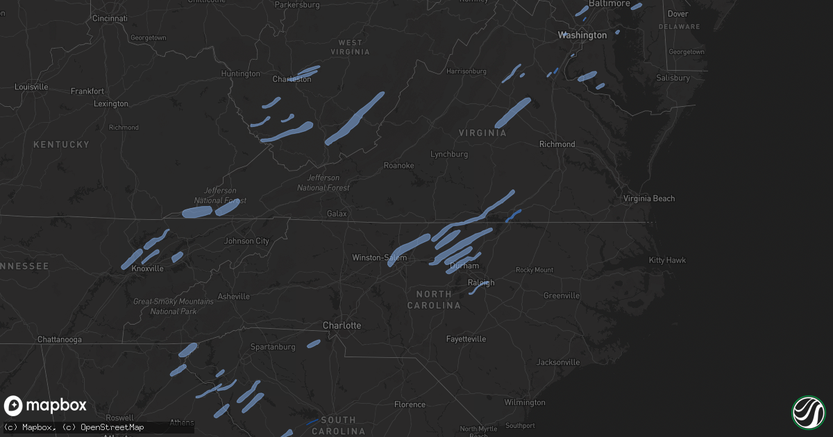
Hail Map in South Carolina on October 31, 2019
Get this storm
October 31 map
$229
one time, instant access
Download today. No call, no setup
Keep the $229
Bought the map and want the full workflow? Apply the entire $229 to a subscription within 7 days. None of it is wasted.
Every map, not just this one
This buys you this map. Subscription and you get every map we run, in the markets you choose from a few cities to whole states to nationwide. Plus real-time alerts the moment a storm fires.
Contact data
Name, contact info, occupancy, even credit band for addresses in the footprint. You go from where it hit to who to call.
Become the source they trust
Unlimited branding weather history reports on demand. You already have the documented answer ready for the property owner, and you are the one who showed up with it.
Property data and RoofTrace estimates
Pull up any address you have got, its value and the exact code rules for that jurisdiction, straight from One Click Code. Then RoofTrace estimates the squares, pitch, and roof value, priced the way you price.
Storm reports in South Carolina
South Carolina
| Date | Description |
|---|---|
| 10/31/20196:52 PM CDT | Reports large limbs down in the town of manning. |
| 10/31/20196:18 PM CDT | Reported trees down near the intersection of highway 31... Bethune road... And highway 15... Old stagecoach road. |
| 10/31/20196:16 PM CDT | Several trees reported down edisto river road. |
| 10/31/20196:03 PM CDT | Allendale warning point reported a tree down near the intersection of confederate highway and jennys road. |
| 10/31/20196:01 PM CDT | Reported trees down along evans mill road. |
| 10/31/20195:58 PM CDT | Reported trees down along arant street near pageland. |
| 10/31/20195:35 PM CDT | Social media spotter report with pictures. Trees down with damage to two vehicles. |
| 10/31/20195:09 PM CDT | The final touchdown occurred near the lexington middle school near the intersection of dreher street and harmon street. A large hardwood tree broke and took down a powe |
| 10/31/20195:08 PM CDT | Social media report of large tree down blocking the road on dreher st just past harmon st. Time estimated by radar. |
| 10/31/20195:02 PM CDT | This is the location of the most widespread tree damage and strongest winds. The tornado once again touched down near clinton sease farms along olde farm road. The torn |
| 10/31/20194:59 PM CDT | A tornado touched down near the intersection of roy steele road and crosby road just northeast of the town of gilbert. It moved quickly to the northeast at nearly 50 mp |
| 10/31/20194:50 PM CDT | Rcwinds mesonet equipment at coast guard island on lake murray measured a 58 mph wind gust. |
| 10/31/20194:45 PM CDT | Trees down in the southeastern portion of the county. |
| 10/31/20194:00 PM CDT | Large oak tree down on pope st. Time estimated by radar. |
| 10/31/20193:50 PM CDT | Trees and powerlines down. |
| 10/31/20193:46 PM CDT | County highway department reported several trees down. |
| 10/31/20193:35 PM CDT | A couple of trees down. |
| 10/31/20193:05 PM CDT | Power lines down. |
| 10/31/20193:00 PM CDT | Several trees down across the county. |
| 10/31/20192:24 PM CDT | Multiple trees down in piedmont. |
| 10/31/20192:17 PM CDT | Multiple trees reported down se of fork shoals. |
| 10/31/20192:15 PM CDT | Large limb down on a car. |
| 10/31/20191:48 PM CDT | Trees down near downtown townville. |
| 10/31/20191:28 PM CDT | A few trees reported down across the county. |
| 10/31/20198:30 AM CDT | A couple of trees down on the north side of the county. Time estimated based on radar. |
| 10/31/20197:35 AM CDT | Several trees down in the northeast part of the county. |
| 10/31/20194:41 AM CDT | At 941 AM EDT, a severe thunderstorm was located 10 miles south of Forest City, or 4 miles northwest of Chesnee, moving northeast at 45 mph. HAZARD...60 mph wind gusts. SOURCE...Radar indicated. IMPACT...Expect damage to trees and power lines. Locations impacted include... Forest City, Lawndale, Polkville, Ellenboro, Lattimore, Mooresboro, Bostic, Kingstown, Cliffside and Henrietta. |
| 10/31/20193:23 AM CDT | At 822 AM EDT, a severe thunderstorm was located 8 miles east of Clemson, or 6 miles east of Pendleton, moving northeast at 50 mph. HAZARD...60 mph wind gusts. SOURCE...Radar indicated. IMPACT...Expect damage to trees and power lines. Locations impacted include... Greenville Downtown, Greenville Eastside, West Greenville, Mauldin, Taylors, Berea, Five Forks, Welcome, Powdersville and Piedmont. |
| 10/31/20192:39 AM CDT | At 738 PM EDT, severe thunderstorms were located along a line extending from 6 miles south of Siler City to near Carthage to near Wadesboro, moving east at 45 mph. HAZARD...60 mph wind gusts. SOURCE...Radar indicated. IMPACT...Expect damage to roofs, siding, and trees. Locations impacted include... Fayetteville, Sanford, Laurinburg, Southern Pines, Raeford, Lillington, Carthage, Fort Bragg, Pinehurst and Dunn. |
| 10/31/20192:27 AM CDT | At 726 PM EDT, severe thunderstorms were located along a line extending from near Shaw Air Base to near Elloree to near Padgetts, moving east at 35 mph. HAZARD...60 mph wind gusts. SOURCE...Radar indicated. IMPACT...Expect damage to roofs, siding, and trees. Locations impacted include... Sumter, Manning, South Sumter, Shaw Air Base, Holly Hill, Branchville, Summerton, Bowman, Elloree, Oakland, Santee State Park, Mulberry, Alcolu, Woods Bay State Park, Santee Cooper Regional Airport, Sumter County Airport, Millwood, Poinsett State Park, Santee and Turbeville.This includes the following highways... Interstate 26 between mile markers 150 and 168. Interstate 95 between mile markers 86 and 146. |
| 10/31/20192:22 AM CDT | At 722 PM EDT, a line of strong and severe thunderstorms was approaching western Marlboro and western Darlington counties, moving northeast at 50 mph. HAZARD...60 mph wind gusts. SOURCE...Radar indicated. IMPACT...Expect wind damage to trees and power lines. Locations impacted include... Hartsville, Darlington, Timmonsville, Lamar, North Hartsville, Dovesville, Lydia, Darlington Raceway, Auburn, Swift Creek, Cartersville, Wallace, Clyde, Oats, Chavistown, Floyd, Kellytown, Society Hill and Carolina Pines Regional Medical Center. |
| 10/31/20191:53 AM CDT | At 653 PM EDT, severe thunderstorms were located along a line extending from near Camden to near Lugoff to 9 miles southeast of Elgin, moving east at 50 mph. HAZARD...60 mph wind gusts. SOURCE...Radar indicated. IMPACT...Expect damage to roofs, siding, and trees. Locations impacted include... Camden, Cheraw, Bishopville, Lake Wateree Dam, Pageland, Kershaw, Chesterfield, Elgin, Heath Springs, Lugoff, Westville, Cheraw State Park, Northeastern Technical College, Cassatt, Elliott, Cheraw Municipal Airport, Lee State Park, Carolina Sandhills Wildlife Refuge, Mt Pisgah and Buford.This includes Interstate 20 in South Carolina between mile markers 85and 125. |
| 10/31/20191:48 AM CDT | At 647 PM EDT, severe thunderstorms were located along a line extending from near Randleman to 7 miles west of Ansonville, moving northeast at 50 mph. HAZARD...60 mph wind gusts. SOURCE...Radar indicated. IMPACT...Expect damage to roofs, siding, and trees. Locations impacted include... Burlington, Asheboro, Graham, Rockingham, Wadesboro, Troy, Siler City, North Carolina Zoo, Mebane and Hamlet. |
| 10/31/20191:46 AM CDT | At 646 PM EDT, severe thunderstorms were located along a line extending from 6 miles south of Sandy Run to 6 miles northwest of Edisto Gardens to Bamberg, moving east at 55 mph. HAZARD...60 mph wind gusts. SOURCE...Radar indicated. IMPACT...Expect damage to roofs, siding, and trees. Locations impacted include... Orangeburg, Bamberg, Denmark, Brookdale, St. Matthews, Branchville, Bowman, Elloree, Claflin College, South Carolina State University, Orangeburg County Airport, Rivers Bridge State Park, Edisto Gardens, North, Ehrhardt, Cameron, Neeses, Norway, Rowesville and Olar.This includes the following highways... Interstate 26 between mile markers 126 and 127, and between milemarkers 131 and 169. Interstate 95 between mile markers 85 and 92. |
| 10/31/20191:26 AM CDT | At 626 PM EDT, a severe thunderstorm was located near Wingate, or near Monroe, moving northeast at 45 mph. HAZARD...60 mph wind gusts. SOURCE...Radar indicated. IMPACT...Expect damage to roofs, siding, and trees. Locations impacted include... Albemarle, Rockingham, Wadesboro, Troy, Biscoe, Ansonville, Polkton, Locust, Norwood and Oakboro. |
| 10/31/20191:12 AM CDT | At 611 PM EDT, severe thunderstorms were located along a line extending from near Lake Wateree State Park to near Red Bank, moving east at 30 mph. HAZARD...60 mph wind gusts. SOURCE...Radar indicated. IMPACT...Expect damage to roofs, siding, and trees. Locations impacted include... Columbia, Lexington, West Columbia, Cayce, Irmo, Forest Acres, Camden, Winnsboro, Springdale, St. Andrews, Dentsville, Oak Grove, McEntire Air Base, Highway 6 at Lake Murray Dam, Red Bank, Lake Wateree Dam, South Congaree, Pine Ridge, Kershaw and Gaston.This includes the following highways... Interstate 126 between mile markers 0 and 3. Interstate 20 in South Carolina between mile markers 47 and 95. Interstate 26 between mile markers 98 and 126. Interstate 77 between mile markers 0 and 50. |
| 10/31/201912:53 AM CDT | At 553 PM EDT, severe thunderstorms were located along a line extending from 6 miles southeast of Uptown Charlotte to 7 miles north of Lancaster, moving northeast at 55 mph. HAZARD...60 mph wind gusts. SOURCE...Radar indicated. IMPACT...Expect damage to trees and power lines. Locations impacted include... Monroe, South Charlotte, East Charlotte, Matthews, Mint Hill, Indian Trail, Weddington, Stallings, Unionville and Harrisburg. |
| 10/31/201912:39 AM CDT | At 538 PM EDT, a severe thunderstorm was located 14 miles southeast of Chester, or 5 miles west of Great Falls, moving northeast at 45 mph. HAZARD...60 mph wind gusts. SOURCE...Radar indicated. IMPACT...Expect damage to trees and power lines. Locations impacted include... Lesslie, Great Falls, Fort Lawn, Richburg, Catawba, Cornwell, Edgemoor, Blackstock and Fishing Creek Reservoir. |
| 10/31/201912:35 AM CDT | At 534 PM EDT, severe thunderstorms were located along a line extending from 6 miles south of Mocksville to 8 miles northeast of Uptown Charlotte to 7 miles north of Indian Land, moving northeast at 50 mph. HAZARD...60 mph wind gusts. SOURCE...Radar indicated. IMPACT...Expect damage to trees and power lines. Locations impacted include... Uptown Charlotte, Kannapolis, Downtown Concord, Salisbury, Mocksville, Central Charlotte, South Charlotte, Northeast Charlotte, Southwest Charlotte and East Charlotte. |
| 10/31/201912:21 AM CDT | At 521 PM EDT, severe thunderstorms were located along a line extending from near Blackstock to near Dreher Island State Park, moving east at 30 mph. HAZARD...60 mph wind gusts. SOURCE...Radar indicated. IMPACT...Expect damage to roofs, siding, and trees. Locations impacted include... Columbia, Lexington, West Columbia, Cayce, Irmo, Forest Acres, Newberry, Batesburg-Leesville, Winnsboro, Springdale, Dentsville, Oak Grove, Lake Wateree Dam, St. Andrews, VC Summer Nuclear Station, Highway 6 at Lake Murray Dam, Red Bank, South Congaree, Pine Ridge and Prosperity.This includes the following highways... Interstate 126 between mile markers 0 and 3. Interstate 20 in South Carolina between mile markers 47 and 88. Interstate 26 between mile markers 75 and 120. Interstate 77 between mile markers 0 and 50. |
| 10/30/201911:58 PM CDT | At 457 PM EDT, severe thunderstorms were located along a line extending from 10 miles east of Lincolnton to 3 miles southeast of Gastonia to 13 miles northwest of Chester, moving northeast at 55 mph. HAZARD...60 mph wind gusts. SOURCE...Radar indicated. IMPACT...Expect damage to trees and power lines. Locations impacted include... Gastonia, Rock Hill, Uptown Charlotte, Huntersville, Kannapolis, Downtown Concord, Salisbury, York, Central Charlotte and South Charlotte. |
| 10/30/201911:43 PM CDT | At 442 PM EDT, severe thunderstorms were located along a line extending from near Appling to near Louisville, moving northeast at 50 mph. HAZARD...60 mph wind gusts and penny size hail. SOURCE...Radar indicated. IMPACT...Expect damage to roofs, siding, and trees. Locations impacted include... North Augusta, Grovetown, Evans, Waynesboro, Fort Gordon, Augusta, Clearwater, Martinez, Belvedere, Edgefield, Hephzibah, Harlem, Glendale, Gough, South Augusta, Clarks Hill Recreation Area, Mistletoe State Park, Summerville, Augusta Mall and Daniel Field.This includes the following highways... Interstate 20 in Georgia between mile markers 178 and 201. Interstate 20 in South Carolina between mile markers 0 and 12. Interstate 520 in Georgia between mile markers 1 and 15. Interstate 520 in South Carolina between mile markers 16 and 23. |
| 10/30/201911:38 PM CDT | At 438 PM EDT, a severe thunderstorm was located near Edgefield, or 21 miles north of Belvedere, moving northeast at 50 mph. HAZARD...60 mph wind gusts. SOURCE...Radar indicated. IMPACT...Expect damage to roofs, siding, and trees. Locations impacted include... Batesburg-Leesville, Edgefield, Saluda, Johnston, Ridge Spring, Saluda County Airport, Monetta, Ward, Strom Thurmond High School, Saluda Co Sheriff's Office, Good Hope, Northside Fire Station Main, Hollywood Elementary School, Emory, Cleora, Delmar, Edgefield Federal Correction Institution, Harmony, Pleasant Lane and Wyses Ferry. |
| 10/30/201911:27 PM CDT | At 426 PM EDT, a severe thunderstorm was located 10 miles north of Greenwood, or 4 miles northeast of Cokesbury, moving northeast at 55 mph.Another strong storm will move across the middle of Greenwood County at about 50 mph. HAZARD...60 mph wind gusts. SOURCE...Radar indicated. IMPACT...Expect damage to trees and power lines. Locations impacted include... Greenwood, Laurens, Abbeville, Clinton, Ware Shoals, Ninety Six, Joanna, Cross Hill, Cokesbury and Waterloo. |
| 10/30/201910:58 PM CDT | At 357 PM EDT, severe thunderstorms were located along a line extending from 6 miles southwest of Rutherfordton to 14 miles east of Greenville Downtown, moving northeast at 45 mph. HAZARD...60 mph wind gusts. SOURCE...Radar indicated. IMPACT...Expect damage to trees and power lines. Locations impacted include... Spartanburg, Shelby, Gaffney, Forest City, Rutherfordton, Boiling Springs SC, Spindale, Boiling Springs NC, Duncan and Lyman. |
| 10/30/201910:46 PM CDT | At 346 PM EDT, severe thunderstorms were located along a line extending from 7 miles northwest of Laurens to 12 miles north of Abbeville, moving northeast at 60 mph. HAZARD...60 mph wind gusts. SOURCE...Radar indicated. IMPACT...Expect damage to trees and power lines. Locations impacted include... Gaffney, Laurens, Union, Clinton, Fountain Inn, Woodruff, Pacolet, Roebuck, Buffalo and Gray Court. |
All States Impacted by Hail Map on October 31, 2019
Cities Impacted by Hail Map on October 31, 2019
- La Crosse, VA
- Boydton, VA
- Bracey, VA
- Brodnax, VA
- Culpeper, VA
- Madison, VA
- Aroda, VA
- Brightwood, VA
- Reva, VA
- Pratts, VA
- Rochelle, VA
- Oakpark, VA
- Mitchells, VA
- Louisa, VA
- Scottsville, VA
- Mineral, VA
- Troy, VA
- Bremo Bluff, VA
- Fork Union, VA
- Kents Store, VA
- Palmyra, VA
- Fredericksburg, VA
- Stafford, VA
- Lorton, VA
- Annapolis, MD
- Lenore, WV
- Williamson, WV
- Logan, WV
- Pecks Mill, WV
- Delbarton, WV
- Chapmanville, WV
- Holden, WV
- Foster, WV
- Julian, WV
- Danville, WV
- Harts, WV
- Big Creek, WV
- Bim, WV
- Wharton, WV
- Twilight, WV
- Gilbert, WV
- Ravencliff, WV
- Glen Rogers, WV
- Fairdale, WV
- Glen Daniel, WV
- Matewan, WV
- Coal Mountain, WV
- Simon, WV
- Surveyor, WV
- Maben, WV
- Baisden, WV
- Saxon, WV
- Wharncliffe, WV
- Beckley, WV
- Lester, WV
- Bolt, WV
- Glen Fork, WV
- Jesse, WV
- Oceana, WV
- Verner, WV
- Matheny, WV
- Arnett, WV
- Cyclone, WV
- Clear Fork, WV
- Slab Fork, WV
- Procious, WV
- Elkview, WV
- Bomont, WV
- Charleston, WV
- Clendenin, WV
- South Charleston, WV
- Crawley, WV
- Pence Springs, WV
- Renick, WV
- Sandstone, WV
- Green Sulphur Springs, WV
- Hinton, WV
- Jumping Branch, WV
- Nimitz, WV
- Williamsburg, WV
- Buckeye, WV
- Grassy Meadows, WV
- Asbury, WV
- Maxwelton, WV
- Hillsboro, WV
- Lewisburg, WV
- Flat Top, WV
- Talcott, WV
- Smoot, WV
- Alderson, WV
- Waterloo, SC
- Abbeville, SC
- Hodges, SC
- Greenwood, SC
- Clayton, GA
- Tiger, GA
- North Augusta, SC
- Grovetown, GA
- Clarks Hill, SC
- Ridge Spring, SC
- Johnston, SC
- Evans, GA
- Augusta, GA
- Trenton, SC
- Monetta, SC
- Harlem, GA
- Graniteville, SC
- Aiken, SC
- Beech Island, SC
- Gibson, GA
- Warrenville, SC
- Avera, GA
- Wrens, GA
- Matthews, GA
- Hephzibah, GA
- Stapleton, GA
- Gloverville, SC
- Blythe, GA
- Keysville, GA
- Bartow, GA
- Wadley, GA
- Waynesboro, GA
- Davisboro, GA
- New Ellenton, SC
- Jackson, SC
- Louisville, GA
- Sharon, SC
- Smyrna, SC
- Clover, SC
- York, SC
- Gilbert, SC
- Lexington, SC
- Reidsville, NC
- Ruffin, NC
- Kernersville, NC
- Colfax, NC
- High Point, NC
- Stokesdale, NC
- Yanceyville, NC
- Greensboro, NC
- Browns Summit, NC
- Summerfield, NC
- Pelham, NC
- Oak Ridge, NC
- Alton, VA
- Virgilina, VA
- Skipwith, VA
- Semora, NC
- Elon, NC
- South Hill, VA
- Milton, NC
- Baskerville, VA
- Kenbridge, VA
- Clarksville, VA
- Nelson, VA
- Roxboro, NC
- Blanch, NC
- Chase City, VA
- Buffalo Junction, VA
- Leasburg, NC
- Prospect Hill, NC
- Mebane, NC
- Hurdle Mills, NC
- Burlington, NC
- Hillsborough, NC
- Cedar Grove, NC
- Henderson, NC
- Graham, NC
- Oxford, NC
- Timberlake, NC
- Haw River, NC
- Rougemont, NC
- Efland, NC
- Bahama, NC
- Stem, NC
- Durham, NC
- Creedmoor, NC
- Butner, NC
- Carrboro, NC
- Chapel Hill, NC
- Raleigh, NC
- Knightdale, NC
- Apex, NC
- Holly Springs, NC
- Fuquay Varina, NC
- Clarkesville, GA
- Demorest, GA
- Mount Airy, GA
- Toccoa, GA
- Long Creek, SC
- Westminster, SC
- Anderson, SC
- Pendleton, SC
- Bowersville, GA
- Canon, GA
- Royston, GA
- Starr, SC
- Hartwell, GA
- Laurens, SC
- Donalds, SC
- Due West, SC
- Iva, SC
- Ware Shoals, SC
- Belton, SC
- Elberton, GA
- Hockessin, DE
- Gladwyne, PA
- Kennett Square, PA
- Wilmington, DE
- Bridgeport, PA
- Newtown Square, PA
- Chalfont, PA
- Paoli, PA
- Blue Bell, PA
- Philadelphia, PA
- Oreland, PA
- Villanova, PA
- Willow Grove, PA
- Berwyn, PA
- Horsham, PA
- Dresher, PA
- Montgomeryville, PA
- Spring House, PA
- Landenberg, PA
- Conshohocken, PA
- Media, PA
- Lafayette Hill, PA
- Newtown, PA
- Hatboro, PA
- Richboro, PA
- Malvern, PA
- Thornton, PA
- Flourtown, PA
- Huntingdon Valley, PA
- King Of Prussia, PA
- Devon, PA
- Avondale, PA
- Toughkenamon, PA
- Southampton, PA
- Doylestown, PA
- West Chester, PA
- Gwynedd, PA
- Cheyney, PA
- Bryn Mawr, PA
- Glen Mills, PA
- Warminster, PA
- Norristown, PA
- Ambler, PA
- North Wales, PA
- Jamison, PA
- Chadds Ford, PA
- Glenside, PA
- Furlong, PA
- Plymouth Meeting, PA
- Wayne, PA
- Warrington, PA
- Abington, PA
- Fort Washington, PA
- Silver Spring, MD
- Oakton, VA
- Vienna, VA
- Worton, MD
- Chestertown, MD
- Faulkner, MD
- Mechanicsville, MD
- Newburg, MD
- King George, VA
- Charlotte Hall, MD
- Dahlgren, VA
- Coltons Point, MD
- Leonardtown, MD
- Bushwood, MD
- Abell, MD
- Avenue, MD
- Brinklow, MD
- Ellicott City, MD
- Brookeville, MD
- Olney, MD
- Highland, MD
- Clarksville, MD
- Rockville, MD
- Dayton, MD
- Sandy Spring, MD
- Derwood, MD
- Norris, TN
- Heiskell, TN
- Oak Ridge, TN
- Clinton, TN
- Andersonville, TN
- Powell, TN
- Corryton, TN
- Luttrell, TN
- Blaine, TN
- Knoxville, TN
- Maynardville, TN
- Sharps Chapel, TN
- Tazewell, TN
- New Tazewell, TN
- Dryden, VA
- Duffield, VA
- Blackwater, VA
- Jonesville, VA
- Rose Hill, VA
- Pennington Gap, VA
- Gate City, VA
- Coeburn, VA
- Nickelsville, VA
- Fort Blackmore, VA
- Dungannon, VA
- Talbott, TN
- Jefferson City, TN
- New Market, TN
- Dandridge, TN
- Morristown, TN


