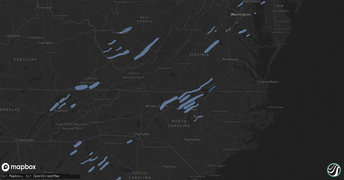
Hail Map in North Carolina on October 31, 2019
Get this storm
October 31 map
$229
one time, instant access
Download today. No call, no setup
Keep the $229
Bought the map and want the full workflow? Apply the entire $229 to a subscription within 7 days. None of it is wasted.
Every map, not just this one
This buys you this map. Subscription and you get every map we run, in the markets you choose from a few cities to whole states to nationwide. Plus real-time alerts the moment a storm fires.
Contact data
Name, contact info, occupancy, even credit band for addresses in the footprint. You go from where it hit to who to call.
Become the source they trust
Unlimited branding weather history reports on demand. You already have the documented answer ready for the property owner, and you are the one who showed up with it.
Property data and RoofTrace estimates
Pull up any address you have got, its value and the exact code rules for that jurisdiction, straight from One Click Code. Then RoofTrace estimates the squares, pitch, and roof value, priced the way you price.
Storm reports in North Carolina
North Carolina
| Date | Description |
|---|---|
| 10/31/20196:50 PM CDT | Moore county 911 received report of tree down across 3000 block of mt carmel rd in carthage. |
| 10/31/20196:48 PM CDT | Tree down on dick holeman rd. |
| 10/31/20196:47 PM CDT | Moore county 911 received call of tree down across 800 block of mcduffey rd between biscoe and robbins. |
| 10/31/20196:45 PM CDT | Corrects previous tstm wnd dmg report from 1 e robbins. Moore county 911 received report of tree down across 2800 block of plank rd in robbins. |
| 10/31/20196:40 PM CDT | Utility pole down due to fallen trees on us 70 w. |
| 10/31/20196:38 PM CDT | Thunderstorm winds downed a tree in siler city along the intersection of grady siler and poe road. |
| 10/31/20196:33 PM CDT | Corrects previous tstm wnd dmg report from 6 sse robbins. Corrects previous tstm wnd dmg report from 6 sse robbins. Moore county 911 received report of tree down across |
| 10/31/20196:30 PM CDT | Corrects previous tstm wnd dmg reports from 1 e robbins. Corrects previous tstm wnd dmg report from 1 e robbins. Moore county 911 received report of tree down across 28 |
| 10/31/20196:25 PM CDT | Tree down. |
| 10/31/20196:22 PM CDT | Corrects previous tstm wnd dmg report from 4 nnw eagle springs. Moore county 911 received call of tree down across 800 block of mcduffey rd between biscoe and robbins. |
| 10/31/20196:18 PM CDT | Thunderstorm winds downed a tree in the city of staley along willard road. |
| 10/31/20196:18 PM CDT | Trees down. |
| 10/31/20196:17 PM CDT | Duke energy reports multiple trees down on equipment. Time estimated from radar. |
| 10/31/20196:15 PM CDT | Thunderstorm winds downed 2 trees in the city of liberty. This includes along the intersection of kidds mill road and ramseur julian road and old siler city road. |
| 10/31/20196:15 PM CDT | Duke energy reports multiple trees down on equipment. Time estimated from radar. |
| 10/31/20196:12 PM CDT | Trees down. |
| 10/31/20196:12 PM CDT | Thunderstorm winds downed a tree in the city of seagrove along the intersection of fork creek mill road and sugg teaugue road. |
| 10/31/20196:10 PM CDT | Thunderstorm winds downed 3 trees in the city of ramseur. This includes along brady street extension and old siler city road. |
| 10/31/20196:00 PM CDT | Trees down. |
| 10/31/20195:58 PM CDT | Trees down. |
| 10/31/20195:58 PM CDT | Thunderstorm winds downed 7 trees in the city of asheboro. This includes along center street and back creek road. |
| 10/31/20195:53 PM CDT | Corrects previous tstm wnd dmg report from 3 e climax. Corrects previous tstm wnd dmg report from 3 e climax. Tree down on nc 62 e. |
| 10/31/20195:48 PM CDT | Thunderstorm winds downed 4 trees in the city of randleman. This includes along north main street and randleman lake road. |
| 10/31/20195:45 PM CDT | Thunderstorm winds downed a tree in the city of pleasant garden along the intersection of racine road and gregson road. |
| 10/31/20195:43 PM CDT | Thunderstorm winds downed a tree near the intersection of high pine church road and lanier road. Time estimated via radar. |
| 10/31/20195:30 PM CDT | Duke energy reports multiple trees down on equipment. Time estimated from radar. |
| 10/31/20195:30 PM CDT | One tree... Approximately 12-18 inches in diameter... Down across driveway. |
| 10/31/20195:28 PM CDT | Thunderstorm winds downed at least 13 trees across the county... Including several in the communities of oxford... Franklinton... And creedmore. |
| 10/31/20195:27 PM CDT | Corrects previous tstm wnd dmg report from 3 sw lake townsend. Corrects previous tstm wnd dmg report from 3 sw lake townsend. Tree down on house on lake jeanette road. |
| 10/31/20195:25 PM CDT | Corrects previous tstm wnd dmg report from 3 nnw greensboro. Corrects previous tstm wnd dmg report from 3 nnw greensboro. Tree down near battleground ave and westridge |
| 10/31/20195:22 PM CDT | Thunderstorm winds downed a tree in the city of trinity along thayer road. |
| 10/31/20195:10 PM CDT | Corrects previous tstm wnd dmg report from 1 sse greensboro. Corrects previous tstm wnd dmg report from 1 sse greensboro. Between 6:10pm and 6:50pm numerous trees blown |
| 10/31/20195:07 PM CDT | Corrects previous tstm wnd dmg report from 5 w high point. Tree down on power lines. Wallburg - high point rd abbots creeks church rd. |
| 10/31/20195:00 PM CDT | A couple of trees down. |
| 10/31/20195:00 PM CDT | Corrects previous tstm wnd dmg report from 3 ene walkertown. Corrects previous tstm wnd dmg report from 3 ene walkertown. Tree down on reidsville road. |
| 10/31/20194:53 PM CDT | Tree down on nc 62 e. |
| 10/31/20194:46 PM CDT | Multiple trees down off orrell trail rd... West of advance. |
| 10/31/20194:46 PM CDT | Trees down on larkwood dr and yadkinville rd. |
| 10/31/20194:27 PM CDT | Tree down on house on lake jeanette road. No injuries. |
| 10/31/20194:25 PM CDT | Tree down near battleground ave and westridge road. |
| 10/31/20194:22 PM CDT | Tree blown down on glenfall ave. |
| 10/31/20194:15 PM CDT | Multiple trees blown down along amity hill rd southeast of statesville. |
| 10/31/20194:10 PM CDT | Between 5:10pm and 5:50pm numerous trees blown down in guilford county. |
| 10/31/20194:07 PM CDT | Tree down on power lines. Wallburg - high point rd abbots creeks church rd. |
| 10/31/20194:00 PM CDT | Powerlines down along lake norman... 3000 customers without power. |
| 10/31/20194:00 PM CDT | About 5 trees down county wide... Some on power lines. Between 5-6pm. |
| 10/31/20194:00 PM CDT | Tree down on reidsville road. |
| 10/31/20193:45 PM CDT | Large tree limbs down on hideaway lane. |
| 10/31/20193:20 PM CDT | Three trees down in fleetwood area between 4:20 and 4:30pm. |
| 10/31/20193:16 PM CDT | Multiple trees down in morganton. |
| 10/31/20193:10 PM CDT | Tree down along highway 1094 in todd. |
| 10/31/20193:04 PM CDT | Trees snapped or uprooted on priscilla drive. |
| 10/31/20192:50 PM CDT | Trees down. |
| 10/31/20192:30 PM CDT | Tree down on s trade street near carson street. |
| 10/31/20192:30 PM CDT | Trees down on buck creek road. |
| 10/31/20192:15 PM CDT | Tree branch through a truck winshield on naples road. |
| 10/31/20191:52 PM CDT | Trees down ne of balsam grove. |
| 10/31/20191:50 PM CDT | Numerous trees and power lines down with a greater concentration between waynesville and cruso. |
| 10/31/20191:50 PM CDT | Numerous trees and power lines down with a greater concentration between waynesville and cruso. |
| 10/31/20191:35 PM CDT | Numerous trees and power lines down with a greater concentration between waynesville and cruso. |
| 10/31/20199:00 AM CDT | Several trees down across the southern part of the county. Time estimated on radar. |
| 10/31/20198:45 AM CDT | Several trees down across the southern part of the county. On tree on a power line sparked a fire on rock corner road near forest city. Time estimated on radar. |
| 10/31/20195:14 AM CDT | At 1014 AM EDT, a severe thunderstorm was located 11 miles northwest of Shelby, or over Polkville, moving northeast at 45 mph. HAZARD...60 mph wind gusts. SOURCE...Radar indicated. IMPACT...Expect damage to trees and power lines. Locations impacted include... Icard, Connelly Springs, Belwood, Lawndale, Polkville, Casar, Kingstown, Cooksville, Vale and Pleasant Grove. |
| 10/31/20194:17 AM CDT | At 917 AM EDT, a severe thunderstorm was located 12 miles northwest of Spartanburg, or near Inman, moving northeast at 50 mph. HAZARD...60 mph wind gusts. SOURCE...Radar indicated. IMPACT...Expect damage to trees and power lines. Locations impacted include... Forest City, Spindale, Inman, Chesnee, Campobello, Bostic, Lake Bowen, Henrietta, Harris and Green Creek. |
| 10/31/20193:59 AM CDT | At 859 PM EDT, severe thunderstorms were located along a line extending from near Wake Forest to near Garner to Fuquay-Varina, moving northeast at 45 mph. HAZARD...60 mph wind gusts. SOURCE...Radar indicated. IMPACT...Expect damage to roofs, siding, and trees. Locations impacted include... Raleigh, Cary, Louisburg, Wake Forest, Garner, Fuquay-Varina, Clayton, Zebulon, Franklinton and Bunn. |
| 10/31/20193:58 AM CDT | At 858 PM EDT, a severe thunderstorm was located 7 miles west of Pope AFB, or 8 miles west of Fort Bragg, moving northeast at 45 mph. HAZARD...60 mph wind gusts. SOURCE...Radar indicated. IMPACT...Expect damage to roofs, siding, and trees. Locations impacted include... Fayetteville, Raeford, Lillington, Fort Bragg, Dunn, Angier, Benson, Godwin, Pope AFB and Spring Lake. |
| 10/31/20193:15 AM CDT | At 814 PM EDT, severe thunderstorms were located along a line extending from near Clarksville to 10 miles north of Oxford to near Butner, moving northeast at 50 mph. HAZARD...60 mph wind gusts. SOURCE...Radar indicated. IMPACT...Expect damage to roofs, siding, and trees. Locations impacted include... Henderson, Oxford, Warrenton, Norlina, Kittrell, Rougemont, Stem, Stovall, Middleburg and Macon. |
| 10/31/20193:13 AM CDT | At 812 PM EDT, severe thunderstorms were located along a line extending from near Rice to near Kells Corner to near Clarksville, moving east at 55 mph. HAZARD...60 mph wind gusts. SOURCE...Radar indicated. IMPACT...Expect damage to trees and powerlines. Severe thunderstorms will be near, Rice around 820 PM EDT. Lunenburg and Jetersville around 825 PM EDT. Kenbridge around 830 PM EDT. Amelia Courthouse and Dundas around 835 PM EDT. Alberta and Chula around 840 PM EDT. South Hill, Moseley, La Crosse and Fort Pickett around 845 PM EDT. Brodnax around 850 PM EDT. McKenney around 855 PM EDT.Other locations impacted by these severe thunderstorms include BaconsFork, North Wellville, Wilburn, Arvins Store, Dolphin, Bowens Corner,Ammon, Murdocks, Nutbush and Finneywood. |
| 10/31/20192:40 AM CDT | At 739 PM EDT, severe thunderstorms were located along a line extending from near Prospect Hill to 7 miles south of Siler City, moving northeast at 55 mph. HAZARD...60 mph wind gusts. SOURCE...Radar indicated. IMPACT...Expect damage to roofs, siding, and trees. Locations impacted include... Raleigh, Durham, Cary, Chapel Hill, Hillsborough, Creedmoor, Pittsboro, Garner, Carrboro and Fuquay-Varina. |
| 10/31/20192:34 AM CDT | At 733 PM EDT, severe thunderstorms were located along a line extending from near Mt Laurel to near Roxboro, moving northeast at 45 mph. HAZARD...60 mph wind gusts and penny size hail. SOURCE...Radar indicated. IMPACT...Expect damage to trees and powerlines. Severe thunderstorms will be near, Clarksville around 810 PM EDT.Other locations impacted by these severe thunderstorms includeWilburn, Spanish Grove, Arvins Store, Finchley, Nutbush, Finneywood,The Falls, Fairview, Plantersville and Rogers Corner. |
| 10/31/20192:17 AM CDT | At 717 PM EDT, a severe thunderstorm was located over Leasburg, or 8 miles west of Roxboro, moving northeast at 60 mph. HAZARD...60 mph wind gusts. SOURCE...Radar indicated. IMPACT...Expect damage to roofs, siding, and trees. Locations impacted include... Roxboro, Rougemont, Concord, Stem, Bethel Hill, Bushy Fork, Hyco Lake, Moriah, Mayo Reservoir and Hyco Marina. |
| 10/31/20192:15 AM CDT | At 715 PM EDT, severe thunderstorms were located along a line extending from near Milton to near Baynes, moving east at 80 mph. HAZARD...60 mph wind gusts. SOURCE...Radar indicated. IMPACT...Expect damage to roofs, siding, and trees. Locations impacted include... Yanceyville... Jericho... Prospect Hill... Milton... Leasburg... Hamer... and Semora. |
| 10/31/20191:41 AM CDT | At 641 PM EDT, a severe thunderstorm was located over Mayfield, moving northeast at 50 mph. HAZARD...60 mph wind gusts. SOURCE...Radar indicated. IMPACT...Expect damage to roofs, siding, and trees. Locations impacted include... Danville... Bethel... Providence... Blairs... Gatewood... Westover Hills... and Pelham.This includes The following Location Danville Airport. |
| 10/31/20191:14 AM CDT | At 614 PM EDT, a severe thunderstorm was located near Greensboro, moving east at 45 mph. HAZARD...60 mph wind gusts. SOURCE...Radar indicated. IMPACT...Expect damage to roofs, siding, and trees. Locations impacted include... Greensboro, Burlington, Asheboro, Graham, Randleman, Mebane, Elon, McLeansville, Summerfield and Gibsonville. |
| 10/31/20191:12 AM CDT | At 612 PM EDT, a severe thunderstorm was located near Pine Hall, or 8 miles southeast of Walnut Cove, moving northeast at 60 mph. HAZARD...60 mph wind gusts. SOURCE...Radar indicated. IMPACT...Expect damage to roofs, siding, and trees. Locations impacted include... Eden... Reidsville... Wentworth... Madison... Mayfield... Intelligence... and Harrisons Crossroads. |
| 10/31/201912:54 AM CDT | At 553 PM EDT, severe thunderstorms were located along a line extending from near Faith to near Midland, moving northeast at 50 mph. HAZARD...60 mph wind gusts. SOURCE...Radar indicated. IMPACT...Expect damage to roofs, siding, and trees. Locations impacted include... Asheboro, Lexington, Albemarle, Badin Lake, Plyler, Locust, Badin, Denton, Stanfield and Richfield. |
| 10/31/201912:49 AM CDT | At 548 PM EDT, a severe thunderstorm was located over Dugspur, or 7 miles southwest of Willis, moving northeast at 40 mph. HAZARD...60 mph wind gusts. SOURCE...Radar indicated. IMPACT...Expect damage to roofs, siding, and trees. Locations impacted include... Floyd... Indian Valley... Copper Hill... Ararat... Ferrum... Woolwine... and Willis. |
| 10/31/201912:33 AM CDT | At 532 PM EDT, a severe thunderstorm was located near Cooleemee, or 9 miles south of Mocksville, moving northeast at 55 mph. HAZARD...60 mph wind gusts. SOURCE...Radar indicated. IMPACT...Expect damage to roofs, siding, and trees. Locations impacted include... Greensboro, Winston-Salem, High Point, Lexington, Thomasville, Kernersville, Clemmons, Bermuda Run, Huntsville and Linwood. |
| 10/31/201912:15 AM CDT | Corrects previous tstm wnd dmg report from 1 wnw peletier... At 1:15am edt... A brief tornado occurred near the intersection of 3 oaks ln and w firetower rd. The tornad |
| 10/31/201912:15 AM CDT | *** 1 inj *** a large branch fell on a vehicle and damaged it on w fire tower rd between rolling hill dr and russell ln. One occupant inside was reportedly injured. |
| 10/31/201912:11 AM CDT | Roof damage in moyock. |
| 10/31/201912:10 AM CDT | Damage to cemented barn fencing. Possible tornado damage. |
| 10/30/201911:30 PM CDT | At 430 PM EDT, severe thunderstorms were located along a line extending from 3 miles southeast of Shelby to 12 miles southeast of Gaffney to 12 miles northeast of Laurens, moving northeast at 40 mph. HAZARD...60 mph wind gusts. SOURCE...Radar indicated. IMPACT...Expect damage to trees and power lines. Locations impacted include... Gastonia, Union, York, Kings Mountain, Mt Holly, Belmont, Cherryville, Bessemer City, South Gastonia and Clover. |
| 10/30/201911:04 PM CDT | At 403 PM EDT, rain showers capable of producing damaging winds were located along a line extending from 7 miles east of Marion to 7 miles northwest of Rutherfordton, moving northeast at 45 mph. HAZARD...60 mph wind gusts. SOURCE...Radar indicated. IMPACT...Expect damage to trees and power lines. Locations impacted include... Lenoir, Morganton, Sawmills, Granite Falls, Valdese, Gamewell, Hudson, Icard, Cajah's Mountain and Drexel. |
| 10/30/201910:33 PM CDT | At 332 PM EDT, rain showers capable of producing damaging winds were located along a line extending from 11 miles east of Erwin to near Spruce Pine to 12 miles west of Marion, moving northeast at 65 mph. HAZARD...60 mph wind gusts. SOURCE...Radar indicated. IMPACT...Expect damage to trees and power lines. Locations impacted include... Lenoir, Marion, Newland, Gamewell, Banner Elk, Elk Park, Beech Mountain In Avery County, Crossnore, Sugar Mountain and Seven Devils. |
| 10/30/201910:12 PM CDT | At 312 PM EDT, rain showers capable of producing damaging winds were located along a line extending from 13 miles southwest of Burnsville to 5 miles southeast of Downtown Asheville to 8 miles northwest of Hendersonville, moving northeast at 55 mph. HAZARD...60 mph wind gusts. SOURCE...Radar indicated. IMPACT...Expect damage to trees and power lines. Locations impacted include... Spruce Pine, Black Mountain, Fairview In Buncombe County, Mountain Home, Old Fort, B.R. Parkway-Little Switzerland To Linville, Mount Mitchell State Park, B.R. Parkway-Craggy To Little Switzerland, Montreat and Pleasant Gardens. |
| 10/30/20199:42 PM CDT | At 242 PM EDT, severe thunderstorms were located along a line extending from 6 miles east of Waynesville to 11 miles northwest of Brevard to 17 miles southeast of Sylva, moving northeast at 45 mph. HAZARD...60 mph wind gusts. SOURCE...Radar indicated. IMPACT...Expect damage to trees and power lines. Locations impacted include... Downtown Asheville, East Asheville, Arden, West Asheville, North Asheville, Mills River, Woodfin, Fletcher, Swannanoa and Canton. |
| 10/30/20199:35 PM CDT | At 234 PM EDT, severe thunderstorms were located along a line extending from 13 miles west of Pickens to 7 miles southwest of Seneca to 5 miles north of Danielsville, moving east at 45 mph. HAZARD...60 mph wind gusts. SOURCE...Radar indicated. IMPACT...Expect damage to trees and power lines. Locations impacted include... Anderson, Easley, Clemson, Seneca, Hartwell, Pickens, Homeland Park, Central, Northlake and Pendleton. |
| 10/30/20198:56 PM CDT | At 155 PM EDT, severe thunderstorms were located along a line extending from 7 miles southwest of Clayton to near Clarkesville to 6 miles west of Homer, moving northeast at 50 mph. HAZARD...60 mph wind gusts. SOURCE...Radar indicated. IMPACT...Expect damage to trees and power lines. Locations impacted include... Toccoa, Seneca, Walhalla, Clayton, Carnesville, Cornelia, Westminster, Lavonia, Gumlog and Mount Airy. |
| 10/30/20198:22 PM CDT | Report from mping: trees uprooted or snapped; roof blown off. |
| 10/30/20198:05 PM CDT | Tree down on mc pherson rd. |
| 10/30/20198:00 PM CDT | Tree down on powerline on lobelia rd. |
| 10/30/20197:49 PM CDT | Thunderstorm winds downed a few trees including snapping a tree in the vicinity of lake wheeler. Time estimated via radar. |
| 10/30/20197:39 PM CDT | Duke energy reports multiple trees down on equipment. Time estimated from radar. |
| 10/30/20197:39 PM CDT | Thunderstorm winds downed a tree along with other branch debris within the vicinity of landmark baptist church. |
| 10/30/20197:35 PM CDT | Moore county 911 received report of tree down across 900 block of brinkley rd in carthage. |
| 10/30/20197:28 PM CDT | Corrects previous tstm wnd dmg report from 1 n oxford. Thunderstorm winds downed at least 13 trees across the county... Including several in the communities of oxford.. |
| 10/30/20197:15 PM CDT | Duke energy reports multiple trees down on equipment. Time estimated from radar. |
| 10/30/20197:15 PM CDT | Thunderstorm winds downed a tree and stripped additional bark off of other trees near a home near the intersection of leon street and n duke street. |
| 10/30/20197:10 PM CDT | Tree and powerline down on mobile home on mt herman church rd and pleasant green rd. |
| 10/30/20197:05 PM CDT | Corrects previous tstm wnd dmg report from 4 ssw carthage. Moore county 911 received report of tree down across 900 block of brinkley rd in carthage. |
| 10/30/20197:05 PM CDT | Moore county 911 received report of tree down across 2800 block of plank rd in robbins. |
| 10/30/20197:04 PM CDT | Mping report of trees uprooted or snapped; roof blown off. |
All States Impacted by Hail Map on October 31, 2019
Cities Impacted by Hail Map on October 31, 2019
- La Crosse, VA
- Boydton, VA
- Bracey, VA
- Brodnax, VA
- Culpeper, VA
- Madison, VA
- Aroda, VA
- Brightwood, VA
- Reva, VA
- Pratts, VA
- Rochelle, VA
- Oakpark, VA
- Mitchells, VA
- Louisa, VA
- Scottsville, VA
- Mineral, VA
- Troy, VA
- Bremo Bluff, VA
- Fork Union, VA
- Kents Store, VA
- Palmyra, VA
- Fredericksburg, VA
- Stafford, VA
- Lorton, VA
- Annapolis, MD
- Lenore, WV
- Williamson, WV
- Logan, WV
- Pecks Mill, WV
- Delbarton, WV
- Chapmanville, WV
- Holden, WV
- Foster, WV
- Julian, WV
- Danville, WV
- Harts, WV
- Big Creek, WV
- Bim, WV
- Wharton, WV
- Twilight, WV
- Gilbert, WV
- Ravencliff, WV
- Glen Rogers, WV
- Fairdale, WV
- Glen Daniel, WV
- Matewan, WV
- Coal Mountain, WV
- Simon, WV
- Surveyor, WV
- Maben, WV
- Baisden, WV
- Saxon, WV
- Wharncliffe, WV
- Beckley, WV
- Lester, WV
- Bolt, WV
- Glen Fork, WV
- Jesse, WV
- Oceana, WV
- Verner, WV
- Matheny, WV
- Arnett, WV
- Cyclone, WV
- Clear Fork, WV
- Slab Fork, WV
- Procious, WV
- Elkview, WV
- Bomont, WV
- Charleston, WV
- Clendenin, WV
- South Charleston, WV
- Crawley, WV
- Pence Springs, WV
- Renick, WV
- Sandstone, WV
- Green Sulphur Springs, WV
- Hinton, WV
- Jumping Branch, WV
- Nimitz, WV
- Williamsburg, WV
- Buckeye, WV
- Grassy Meadows, WV
- Asbury, WV
- Maxwelton, WV
- Hillsboro, WV
- Lewisburg, WV
- Flat Top, WV
- Talcott, WV
- Smoot, WV
- Alderson, WV
- Waterloo, SC
- Abbeville, SC
- Hodges, SC
- Greenwood, SC
- Clayton, GA
- Tiger, GA
- North Augusta, SC
- Grovetown, GA
- Clarks Hill, SC
- Ridge Spring, SC
- Johnston, SC
- Evans, GA
- Augusta, GA
- Trenton, SC
- Monetta, SC
- Harlem, GA
- Graniteville, SC
- Aiken, SC
- Beech Island, SC
- Gibson, GA
- Warrenville, SC
- Avera, GA
- Wrens, GA
- Matthews, GA
- Hephzibah, GA
- Stapleton, GA
- Gloverville, SC
- Blythe, GA
- Keysville, GA
- Bartow, GA
- Wadley, GA
- Waynesboro, GA
- Davisboro, GA
- New Ellenton, SC
- Jackson, SC
- Louisville, GA
- Sharon, SC
- Smyrna, SC
- Clover, SC
- York, SC
- Gilbert, SC
- Lexington, SC
- Reidsville, NC
- Ruffin, NC
- Kernersville, NC
- Colfax, NC
- High Point, NC
- Stokesdale, NC
- Yanceyville, NC
- Greensboro, NC
- Browns Summit, NC
- Summerfield, NC
- Pelham, NC
- Oak Ridge, NC
- Alton, VA
- Virgilina, VA
- Skipwith, VA
- Semora, NC
- Elon, NC
- South Hill, VA
- Milton, NC
- Baskerville, VA
- Kenbridge, VA
- Clarksville, VA
- Nelson, VA
- Roxboro, NC
- Blanch, NC
- Chase City, VA
- Buffalo Junction, VA
- Leasburg, NC
- Prospect Hill, NC
- Mebane, NC
- Hurdle Mills, NC
- Burlington, NC
- Hillsborough, NC
- Cedar Grove, NC
- Henderson, NC
- Graham, NC
- Oxford, NC
- Timberlake, NC
- Haw River, NC
- Rougemont, NC
- Efland, NC
- Bahama, NC
- Stem, NC
- Durham, NC
- Creedmoor, NC
- Butner, NC
- Carrboro, NC
- Chapel Hill, NC
- Raleigh, NC
- Knightdale, NC
- Apex, NC
- Holly Springs, NC
- Fuquay Varina, NC
- Clarkesville, GA
- Demorest, GA
- Mount Airy, GA
- Toccoa, GA
- Long Creek, SC
- Westminster, SC
- Anderson, SC
- Pendleton, SC
- Bowersville, GA
- Canon, GA
- Royston, GA
- Starr, SC
- Hartwell, GA
- Laurens, SC
- Donalds, SC
- Due West, SC
- Iva, SC
- Ware Shoals, SC
- Belton, SC
- Elberton, GA
- Hockessin, DE
- Gladwyne, PA
- Kennett Square, PA
- Wilmington, DE
- Bridgeport, PA
- Newtown Square, PA
- Chalfont, PA
- Paoli, PA
- Blue Bell, PA
- Philadelphia, PA
- Oreland, PA
- Villanova, PA
- Willow Grove, PA
- Berwyn, PA
- Horsham, PA
- Dresher, PA
- Montgomeryville, PA
- Spring House, PA
- Landenberg, PA
- Conshohocken, PA
- Media, PA
- Lafayette Hill, PA
- Newtown, PA
- Hatboro, PA
- Richboro, PA
- Malvern, PA
- Thornton, PA
- Flourtown, PA
- Huntingdon Valley, PA
- King Of Prussia, PA
- Devon, PA
- Avondale, PA
- Toughkenamon, PA
- Southampton, PA
- Doylestown, PA
- West Chester, PA
- Gwynedd, PA
- Cheyney, PA
- Bryn Mawr, PA
- Glen Mills, PA
- Warminster, PA
- Norristown, PA
- Ambler, PA
- North Wales, PA
- Jamison, PA
- Chadds Ford, PA
- Glenside, PA
- Furlong, PA
- Plymouth Meeting, PA
- Wayne, PA
- Warrington, PA
- Abington, PA
- Fort Washington, PA
- Silver Spring, MD
- Oakton, VA
- Vienna, VA
- Worton, MD
- Chestertown, MD
- Faulkner, MD
- Mechanicsville, MD
- Newburg, MD
- King George, VA
- Charlotte Hall, MD
- Dahlgren, VA
- Coltons Point, MD
- Leonardtown, MD
- Bushwood, MD
- Abell, MD
- Avenue, MD
- Brinklow, MD
- Ellicott City, MD
- Brookeville, MD
- Olney, MD
- Highland, MD
- Clarksville, MD
- Rockville, MD
- Dayton, MD
- Sandy Spring, MD
- Derwood, MD
- Norris, TN
- Heiskell, TN
- Oak Ridge, TN
- Clinton, TN
- Andersonville, TN
- Powell, TN
- Corryton, TN
- Luttrell, TN
- Blaine, TN
- Knoxville, TN
- Maynardville, TN
- Sharps Chapel, TN
- Tazewell, TN
- New Tazewell, TN
- Dryden, VA
- Duffield, VA
- Blackwater, VA
- Jonesville, VA
- Rose Hill, VA
- Pennington Gap, VA
- Gate City, VA
- Coeburn, VA
- Nickelsville, VA
- Fort Blackmore, VA
- Dungannon, VA
- Talbott, TN
- Jefferson City, TN
- New Market, TN
- Dandridge, TN
- Morristown, TN


