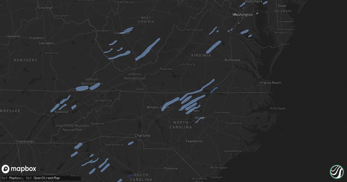
Hail Map on October 31, 2019
Get this storm
October 31 map
$229
one time, instant access
Download today. No call, no setup
Keep the $229
Bought the map and want the full workflow? Apply the entire $229 to a subscription within 7 days. None of it is wasted.
Every map, not just this one
This buys you this map. Subscription and you get every map we run, in the markets you choose from a few cities to whole states to nationwide. Plus real-time alerts the moment a storm fires.
Contact data
Name, contact info, occupancy, even credit band for addresses in the footprint. You go from where it hit to who to call.
Become the source they trust
Unlimited branding weather history reports on demand. You already have the documented answer ready for the property owner, and you are the one who showed up with it.
Property data and RoofTrace estimates
Pull up any address you have got, its value and the exact code rules for that jurisdiction, straight from One Click Code. Then RoofTrace estimates the squares, pitch, and roof value, priced the way you price.
States Impacted by Hail Map on October 31, 2019
Storm reports
New Jersey
| Date | Description |
|---|---|
| 10/31/20196:34 AM CDT | At 1133 PM EDT, a severe thunderstorm was located over West Milford, moving northeast at 70 mph. HAZARD...60 mph wind gusts. SOURCE...Radar indicated. IMPACT...Expect damage to trees and power lines. This severe thunderstorm will be near... Greenwood Lake around 1140 PM EDT. Sloatsburg around 1145 PM EDT. Monroe and Pomona around 1150 PM EDT. Peekskill around 1155 PM EDT. Cold Spring and West Point around 1200 AM EDT. Mahopac and Fahnestock State Park around 1205 AM EDT. Lake Carmel and Carmel around 1210 AM EDT. New York--Newark around 1215 AM EDT. New Fairfield around 1220 AM EDT. Sherman around 1225 AM EDT. |
| 10/31/20194:56 AM CDT | At 956 PM EDT, severe thunderstorms were located along a line extending from near Tobyhanna to near Leesport, moving northeast at 65 mph. HAZARD...60 mph wind gusts. SOURCE...Radar indicated. IMPACT...Damage to roofs, siding, trees, and power lines is possible. Locations impacted include... Allentown, Easton, Mount Pocono, Bethlehem, Forks, Emmaus, Northampton, East Stroudsburg, Wilson, Hellertown, Nazareth, Palmerton, Bangor, Slatington, Pen Argyl, Wind Gap, Bath, Walnutport, Belfast and West Easton.This includes the following highways... Interstate 78 in New Jersey near mile marker 0. Interstate 80 in Pennsylvania between mile markers 294 and 314. Interstate 78 in Pennsylvania between mile markers 45 and 76. |
| 10/31/20191:18 AM CDT | Hads gauge. |
| 10/31/20191:08 AM CDT | Large tree uprooted. Time estimated from radar. |
| 10/31/20191:06 AM CDT | Downed tree on garden state parkway southbound south of exit 98. Lane restrictions in place. Time estimated from radar. |
| 10/31/20191:06 AM CDT | Downed trees and wires on state highway 34 south of monmouth executive airport. All lanes closed. Time estimated from radar. |
| 10/31/201912:35 AM CDT | Downed power lines on state highway 27 south of grove avenue. All lanes closed. Time estimated from radar. |
| 10/31/201912:28 AM CDT | Downed tree on state highway 24 west of exit 7. Lane restrictions in place. Time estimated from radar. |
| 10/31/201912:23 AM CDT | An ef-1 tornado with a somewhat discontinuous damage path touched down in harding township along pleasantville road. Numerous trees were snapped and uprooted in this ar |
| 10/31/201912:23 AM CDT | Report from mping: 1-inch tree limbs broken; shingles blown off. Time estimated from radar. |
| 10/31/201912:18 AM CDT | Downed tree on state highway 64 southbound near cranbury road. All lanes closed. Time estimated from radar. |
| 10/31/201912:18 AM CDT | Hads gauge. |
| 10/31/201912:18 AM CDT | Downed tree on u.s. Highway 202 north of finney avenue. All lanes closed. Time estimated from radar. |
| 10/31/201912:15 AM CDT | Downed tree and wires on u.s. Highway 206 southbound south of dukes parkway west. Lane restrictions in place. Time estimated from radar. |
| 10/31/201912:15 AM CDT | Downed tree on interstate 287 northbound north of exit 26. Lane closures in place. Time estimated from radar. |
| 10/31/201912:15 AM CDT | Report from mping: 1-inch tree limbs broken; shingles blown off. |
| 10/31/201912:14 AM CDT | Emergency management reports numerous trees uprooted throughout hillsborough twp. Time estimated from radar. |
| 10/31/201912:10 AM CDT | Downed tree on state highway 23 south of beaver lake road. All lanes closed. Time estimated from radar. |
| 10/31/201912:08 AM CDT | Large tree uprooted. Time estimated from radar. |
| 10/31/201912:06 AM CDT | Downed trees and wires on state highway 34 south of monmouth executive airport. All lanes closed. Time estimated from radar. |
| 10/31/201912:06 AM CDT | Downed tree on garden state parkway southbound south of exit 98. Lane restrictions in place. Time estimated from radar. |
| 10/31/201912:05 AM CDT | Downed tree on state highway 10 eastbound near county road 617. All lanes closed. Time estimated from radar. |
| 10/31/201912:05 AM CDT | Report from mping: 3-inch tree limbs broken; power poles broken. Time estimated from radar. |
| 10/31/201912:00 AM CDT | Downed tree on u.s. Highway 206 north of flanders netcong road. All lanes closed. Time estimated from radar. |
| 10/31/201912:00 AM CDT | Downed tree on state highway 29 between washington crossing road and valley road. All lanes closed. Time estimated from radar. |
| 10/30/201911:57 PM CDT | Downed power lines on u.s. Highway 130 southbound south of union avenue. Lane restrictions in place. Time estimated from radar. |
| 10/30/201911:54 PM CDT | Photo showing a large tree down on power lines. Report indicates several additional trees are down on power lines with some transformer fires in the area. Time estimate |
| 10/30/201911:54 PM CDT | Downed tree on state highway 29 south of brookville hollow road. All lanes closed. Time estimated from radar. |
| 10/30/201911:52 PM CDT | *** 1 inj *** large tree fell onto a house. One serious injury reported. |
| 10/30/201911:52 PM CDT | Downed power lines on state highway 29 south of ferry street. All lanes closed. |
| 10/30/201911:50 PM CDT | Large tree down on power lines on hamilton dr. Time estimated from radar. |
| 10/30/201911:49 PM CDT | Several reports of downed trees and power lines in allamuchy twp and hackettstown. Time estimated from radar. |
| 10/30/201911:37 PM CDT | Several reports of downed trees in oxford twp... Including on jonestown road and washington avenue. Time estimated from radar. |
| 10/30/201911:35 PM CDT | Downed power lines on state highway 27 south of grove avenue. All lanes closed. Time estimated from radar. |
| 10/30/201911:34 PM CDT | Corrects previous tstm wnd dmg report from 1 se west caldwell. Storm spotter reports a large tree down near passaic... Nj as well as a report of a tree collapsed onto a |
| 10/30/201911:29 PM CDT | Trees and wires down on pinchers point road... River road... Edge road... And still valley road. Time estimated from radar. |
| 10/30/201911:28 PM CDT | Downed tree on state highway 24 west of exit 7. Lane restrictions in place. Time estimated from radar. |
| 10/30/201911:23 PM CDT | Report from mping: 1-inch tree limbs broken; shingles blown off. Time estimated from radar. |
| 10/30/201911:19 PM CDT | Several reports of downed trees and power lines in phillipsburg and lopatcong twp. Time estimated from radar. |
| 10/30/201911:18 PM CDT | Downed tree on u.s. Highway 202 north of finney avenue. All lanes closed. Time estimated from radar. |
| 10/30/201911:18 PM CDT | Downed tree on state highway 64 southbound near cranbury road. All lanes closed. Time estimated from radar. |
| 10/30/201911:15 PM CDT | Report from mping: 1-inch tree limbs broken; shingles blown off. |
| 10/30/201911:15 PM CDT | Downed tree and wires on u.s. Highway 206 southbound south of dukes parkway west. Lane restrictions in place. Time estimated from radar. |
| 10/30/201911:15 PM CDT | Downed tree on interstate 287 northbound north of exit 26. Lane closures in place. Time estimated from radar. |
| 10/30/201911:14 PM CDT | Emergency management reports numerous trees uprooted throughout hillsborough twp. Time estimated from radar. |
| 10/30/201911:10 PM CDT | Downed tree on state highway 23 south of beaver lake road. All lanes closed. Time estimated from radar. |
| 10/30/201911:05 PM CDT | Downed tree on state highway 10 eastbound near county road 617. All lanes closed. Time estimated from radar. |
| 10/30/201911:05 PM CDT | Report from mping: 3-inch tree limbs broken; power poles broken. Time estimated from radar. |
| 10/30/201911:00 PM CDT | Downed tree on u.s. Highway 206 north of flanders netcong road. All lanes closed. Time estimated from radar. |
| 10/30/201911:00 PM CDT | Downed tree on state highway 29 between washington crossing road and valley road. All lanes closed. Time estimated from radar. |
| 10/30/201910:57 PM CDT | Downed power lines on u.s. Highway 130 southbound south of union avenue. Lane restrictions in place. Time estimated from radar. |
| 10/30/201910:54 PM CDT | Downed tree on state highway 29 south of brookville hollow road. All lanes closed. Time estimated from radar. |
| 10/30/201910:54 PM CDT | Photo showing a large tree down on power lines. Report indicates several additional trees are down on power lines with some transformer fires in the area. Time estimate |
| 10/30/201910:52 PM CDT | *** 1 inj *** large tree fell onto a house. One serious injury reported. |
| 10/30/201910:52 PM CDT | Downed power lines on state highway 29 south of ferry street. All lanes closed. |
| 10/30/201910:50 PM CDT | Large tree down on power lines on hamilton dr. Time estimated from radar. |
| 10/30/201910:49 PM CDT | Several reports of downed trees and power lines in allamuchy twp and hackettstown. Time estimated from radar. |
| 10/30/201910:37 PM CDT | Several reports of downed trees in oxford twp... Including on jonestown road and washington avenue. Time estimated from radar. |
| 10/30/201910:29 PM CDT | Trees and wires down on pinchers point road... River road... Edge road... And still valley road. Time estimated from radar. |
| 10/30/201910:19 PM CDT | Several reports of downed trees and power lines in phillipsburg and lopatcong twp. Time estimated from radar. |
Vermont
| Date | Description |
|---|---|
| 10/31/20196:54 AM CDT | At 1153 PM EDT, a severe thunderstorm was located over Kinderhook, or near Chatham, moving east at 60 mph. HAZARD...60 mph wind gusts. SOURCE...Radar indicated. IMPACT...Expect damage to roofs, siding, and trees. Locations impacted include... Albany, Troy, East Greenbush, Watervliet, Rensselaer, Colonie, Hudson, Catskill, Chatham, Nassau, Delmar, Latham, Guilderland, Claverack, Menands, Livingston, Copake, New Baltimore, Ravena and Stephentown. |
North Carolina
| Date | Description |
|---|---|
| 10/31/20196:50 PM CDT | Moore county 911 received report of tree down across 3000 block of mt carmel rd in carthage. |
| 10/31/20196:48 PM CDT | Tree down on dick holeman rd. |
| 10/31/20196:47 PM CDT | Moore county 911 received call of tree down across 800 block of mcduffey rd between biscoe and robbins. |
| 10/31/20196:45 PM CDT | Corrects previous tstm wnd dmg report from 1 e robbins. Moore county 911 received report of tree down across 2800 block of plank rd in robbins. |
| 10/31/20196:40 PM CDT | Utility pole down due to fallen trees on us 70 w. |
| 10/31/20196:38 PM CDT | Thunderstorm winds downed a tree in siler city along the intersection of grady siler and poe road. |
| 10/31/20196:33 PM CDT | Corrects previous tstm wnd dmg report from 6 sse robbins. Corrects previous tstm wnd dmg report from 6 sse robbins. Moore county 911 received report of tree down across |
| 10/31/20196:30 PM CDT | Corrects previous tstm wnd dmg reports from 1 e robbins. Corrects previous tstm wnd dmg report from 1 e robbins. Moore county 911 received report of tree down across 28 |
| 10/31/20196:25 PM CDT | Tree down. |
| 10/31/20196:22 PM CDT | Corrects previous tstm wnd dmg report from 4 nnw eagle springs. Moore county 911 received call of tree down across 800 block of mcduffey rd between biscoe and robbins. |
| 10/31/20196:18 PM CDT | Thunderstorm winds downed a tree in the city of staley along willard road. |
| 10/31/20196:18 PM CDT | Trees down. |
| 10/31/20196:17 PM CDT | Duke energy reports multiple trees down on equipment. Time estimated from radar. |
| 10/31/20196:15 PM CDT | Thunderstorm winds downed 2 trees in the city of liberty. This includes along the intersection of kidds mill road and ramseur julian road and old siler city road. |
| 10/31/20196:15 PM CDT | Duke energy reports multiple trees down on equipment. Time estimated from radar. |
| 10/31/20196:12 PM CDT | Trees down. |
| 10/31/20196:12 PM CDT | Thunderstorm winds downed a tree in the city of seagrove along the intersection of fork creek mill road and sugg teaugue road. |
| 10/31/20196:10 PM CDT | Thunderstorm winds downed 3 trees in the city of ramseur. This includes along brady street extension and old siler city road. |
| 10/31/20196:00 PM CDT | Trees down. |
| 10/31/20195:58 PM CDT | Trees down. |
| 10/31/20195:58 PM CDT | Thunderstorm winds downed 7 trees in the city of asheboro. This includes along center street and back creek road. |
| 10/31/20195:53 PM CDT | Corrects previous tstm wnd dmg report from 3 e climax. Corrects previous tstm wnd dmg report from 3 e climax. Tree down on nc 62 e. |
| 10/31/20195:48 PM CDT | Thunderstorm winds downed 4 trees in the city of randleman. This includes along north main street and randleman lake road. |
| 10/31/20195:45 PM CDT | Thunderstorm winds downed a tree in the city of pleasant garden along the intersection of racine road and gregson road. |
| 10/31/20195:43 PM CDT | Thunderstorm winds downed a tree near the intersection of high pine church road and lanier road. Time estimated via radar. |
| 10/31/20195:30 PM CDT | Duke energy reports multiple trees down on equipment. Time estimated from radar. |
| 10/31/20195:30 PM CDT | One tree... Approximately 12-18 inches in diameter... Down across driveway. |
| 10/31/20195:28 PM CDT | Thunderstorm winds downed at least 13 trees across the county... Including several in the communities of oxford... Franklinton... And creedmore. |
| 10/31/20195:27 PM CDT | Corrects previous tstm wnd dmg report from 3 sw lake townsend. Corrects previous tstm wnd dmg report from 3 sw lake townsend. Tree down on house on lake jeanette road. |
| 10/31/20195:25 PM CDT | Corrects previous tstm wnd dmg report from 3 nnw greensboro. Corrects previous tstm wnd dmg report from 3 nnw greensboro. Tree down near battleground ave and westridge |
| 10/31/20195:22 PM CDT | Thunderstorm winds downed a tree in the city of trinity along thayer road. |
| 10/31/20195:10 PM CDT | Corrects previous tstm wnd dmg report from 1 sse greensboro. Corrects previous tstm wnd dmg report from 1 sse greensboro. Between 6:10pm and 6:50pm numerous trees blown |
| 10/31/20195:07 PM CDT | Corrects previous tstm wnd dmg report from 5 w high point. Tree down on power lines. Wallburg - high point rd abbots creeks church rd. |
| 10/31/20195:00 PM CDT | A couple of trees down. |
| 10/31/20195:00 PM CDT | Corrects previous tstm wnd dmg report from 3 ene walkertown. Corrects previous tstm wnd dmg report from 3 ene walkertown. Tree down on reidsville road. |
| 10/31/20194:53 PM CDT | Tree down on nc 62 e. |
| 10/31/20194:46 PM CDT | Trees down on larkwood dr and yadkinville rd. |
| 10/31/20194:46 PM CDT | Multiple trees down off orrell trail rd... West of advance. |
| 10/31/20194:27 PM CDT | Tree down on house on lake jeanette road. No injuries. |
| 10/31/20194:25 PM CDT | Tree down near battleground ave and westridge road. |
| 10/31/20194:22 PM CDT | Tree blown down on glenfall ave. |
| 10/31/20194:15 PM CDT | Multiple trees blown down along amity hill rd southeast of statesville. |
| 10/31/20194:10 PM CDT | Between 5:10pm and 5:50pm numerous trees blown down in guilford county. |
| 10/31/20194:07 PM CDT | Tree down on power lines. Wallburg - high point rd abbots creeks church rd. |
| 10/31/20194:00 PM CDT | Tree down on reidsville road. |
| 10/31/20194:00 PM CDT | Powerlines down along lake norman... 3000 customers without power. |
| 10/31/20194:00 PM CDT | About 5 trees down county wide... Some on power lines. Between 5-6pm. |
| 10/31/20193:45 PM CDT | Large tree limbs down on hideaway lane. |
| 10/31/20193:20 PM CDT | Three trees down in fleetwood area between 4:20 and 4:30pm. |
| 10/31/20193:16 PM CDT | Multiple trees down in morganton. |
| 10/31/20193:10 PM CDT | Tree down along highway 1094 in todd. |
| 10/31/20193:04 PM CDT | Trees snapped or uprooted on priscilla drive. |
| 10/31/20192:50 PM CDT | Trees down. |
| 10/31/20192:30 PM CDT | Tree down on s trade street near carson street. |
| 10/31/20192:30 PM CDT | Trees down on buck creek road. |
| 10/31/20192:15 PM CDT | Tree branch through a truck winshield on naples road. |
| 10/31/20191:52 PM CDT | Trees down ne of balsam grove. |
| 10/31/20191:50 PM CDT | Numerous trees and power lines down with a greater concentration between waynesville and cruso. |
| 10/31/20191:50 PM CDT | Numerous trees and power lines down with a greater concentration between waynesville and cruso. |
| 10/31/20191:35 PM CDT | Numerous trees and power lines down with a greater concentration between waynesville and cruso. |
| 10/31/20199:00 AM CDT | Several trees down across the southern part of the county. Time estimated on radar. |
| 10/31/20198:45 AM CDT | Several trees down across the southern part of the county. On tree on a power line sparked a fire on rock corner road near forest city. Time estimated on radar. |
| 10/31/20195:14 AM CDT | At 1014 AM EDT, a severe thunderstorm was located 11 miles northwest of Shelby, or over Polkville, moving northeast at 45 mph. HAZARD...60 mph wind gusts. SOURCE...Radar indicated. IMPACT...Expect damage to trees and power lines. Locations impacted include... Icard, Connelly Springs, Belwood, Lawndale, Polkville, Casar, Kingstown, Cooksville, Vale and Pleasant Grove. |
| 10/31/20194:17 AM CDT | At 917 AM EDT, a severe thunderstorm was located 12 miles northwest of Spartanburg, or near Inman, moving northeast at 50 mph. HAZARD...60 mph wind gusts. SOURCE...Radar indicated. IMPACT...Expect damage to trees and power lines. Locations impacted include... Forest City, Spindale, Inman, Chesnee, Campobello, Bostic, Lake Bowen, Henrietta, Harris and Green Creek. |
| 10/31/20193:59 AM CDT | At 859 PM EDT, severe thunderstorms were located along a line extending from near Wake Forest to near Garner to Fuquay-Varina, moving northeast at 45 mph. HAZARD...60 mph wind gusts. SOURCE...Radar indicated. IMPACT...Expect damage to roofs, siding, and trees. Locations impacted include... Raleigh, Cary, Louisburg, Wake Forest, Garner, Fuquay-Varina, Clayton, Zebulon, Franklinton and Bunn. |
| 10/31/20193:58 AM CDT | At 858 PM EDT, a severe thunderstorm was located 7 miles west of Pope AFB, or 8 miles west of Fort Bragg, moving northeast at 45 mph. HAZARD...60 mph wind gusts. SOURCE...Radar indicated. IMPACT...Expect damage to roofs, siding, and trees. Locations impacted include... Fayetteville, Raeford, Lillington, Fort Bragg, Dunn, Angier, Benson, Godwin, Pope AFB and Spring Lake. |
| 10/31/20193:15 AM CDT | At 814 PM EDT, severe thunderstorms were located along a line extending from near Clarksville to 10 miles north of Oxford to near Butner, moving northeast at 50 mph. HAZARD...60 mph wind gusts. SOURCE...Radar indicated. IMPACT...Expect damage to roofs, siding, and trees. Locations impacted include... Henderson, Oxford, Warrenton, Norlina, Kittrell, Rougemont, Stem, Stovall, Middleburg and Macon. |
| 10/31/20193:13 AM CDT | At 812 PM EDT, severe thunderstorms were located along a line extending from near Rice to near Kells Corner to near Clarksville, moving east at 55 mph. HAZARD...60 mph wind gusts. SOURCE...Radar indicated. IMPACT...Expect damage to trees and powerlines. Severe thunderstorms will be near, Rice around 820 PM EDT. Lunenburg and Jetersville around 825 PM EDT. Kenbridge around 830 PM EDT. Amelia Courthouse and Dundas around 835 PM EDT. Alberta and Chula around 840 PM EDT. South Hill, Moseley, La Crosse and Fort Pickett around 845 PM EDT. Brodnax around 850 PM EDT. McKenney around 855 PM EDT.Other locations impacted by these severe thunderstorms include BaconsFork, North Wellville, Wilburn, Arvins Store, Dolphin, Bowens Corner,Ammon, Murdocks, Nutbush and Finneywood. |
| 10/31/20192:40 AM CDT | At 739 PM EDT, severe thunderstorms were located along a line extending from near Prospect Hill to 7 miles south of Siler City, moving northeast at 55 mph. HAZARD...60 mph wind gusts. SOURCE...Radar indicated. IMPACT...Expect damage to roofs, siding, and trees. Locations impacted include... Raleigh, Durham, Cary, Chapel Hill, Hillsborough, Creedmoor, Pittsboro, Garner, Carrboro and Fuquay-Varina. |
| 10/31/20192:34 AM CDT | At 733 PM EDT, severe thunderstorms were located along a line extending from near Mt Laurel to near Roxboro, moving northeast at 45 mph. HAZARD...60 mph wind gusts and penny size hail. SOURCE...Radar indicated. IMPACT...Expect damage to trees and powerlines. Severe thunderstorms will be near, Clarksville around 810 PM EDT.Other locations impacted by these severe thunderstorms includeWilburn, Spanish Grove, Arvins Store, Finchley, Nutbush, Finneywood,The Falls, Fairview, Plantersville and Rogers Corner. |
| 10/31/20192:17 AM CDT | At 717 PM EDT, a severe thunderstorm was located over Leasburg, or 8 miles west of Roxboro, moving northeast at 60 mph. HAZARD...60 mph wind gusts. SOURCE...Radar indicated. IMPACT...Expect damage to roofs, siding, and trees. Locations impacted include... Roxboro, Rougemont, Concord, Stem, Bethel Hill, Bushy Fork, Hyco Lake, Moriah, Mayo Reservoir and Hyco Marina. |
| 10/31/20192:15 AM CDT | At 715 PM EDT, severe thunderstorms were located along a line extending from near Milton to near Baynes, moving east at 80 mph. HAZARD...60 mph wind gusts. SOURCE...Radar indicated. IMPACT...Expect damage to roofs, siding, and trees. Locations impacted include... Yanceyville... Jericho... Prospect Hill... Milton... Leasburg... Hamer... and Semora. |
| 10/31/20191:41 AM CDT | At 641 PM EDT, a severe thunderstorm was located over Mayfield, moving northeast at 50 mph. HAZARD...60 mph wind gusts. SOURCE...Radar indicated. IMPACT...Expect damage to roofs, siding, and trees. Locations impacted include... Danville... Bethel... Providence... Blairs... Gatewood... Westover Hills... and Pelham.This includes The following Location Danville Airport. |
| 10/31/20191:14 AM CDT | At 614 PM EDT, a severe thunderstorm was located near Greensboro, moving east at 45 mph. HAZARD...60 mph wind gusts. SOURCE...Radar indicated. IMPACT...Expect damage to roofs, siding, and trees. Locations impacted include... Greensboro, Burlington, Asheboro, Graham, Randleman, Mebane, Elon, McLeansville, Summerfield and Gibsonville. |
| 10/31/20191:12 AM CDT | At 612 PM EDT, a severe thunderstorm was located near Pine Hall, or 8 miles southeast of Walnut Cove, moving northeast at 60 mph. HAZARD...60 mph wind gusts. SOURCE...Radar indicated. IMPACT...Expect damage to roofs, siding, and trees. Locations impacted include... Eden... Reidsville... Wentworth... Madison... Mayfield... Intelligence... and Harrisons Crossroads. |
| 10/31/201912:54 AM CDT | At 553 PM EDT, severe thunderstorms were located along a line extending from near Faith to near Midland, moving northeast at 50 mph. HAZARD...60 mph wind gusts. SOURCE...Radar indicated. IMPACT...Expect damage to roofs, siding, and trees. Locations impacted include... Asheboro, Lexington, Albemarle, Badin Lake, Plyler, Locust, Badin, Denton, Stanfield and Richfield. |
| 10/31/201912:49 AM CDT | At 548 PM EDT, a severe thunderstorm was located over Dugspur, or 7 miles southwest of Willis, moving northeast at 40 mph. HAZARD...60 mph wind gusts. SOURCE...Radar indicated. IMPACT...Expect damage to roofs, siding, and trees. Locations impacted include... Floyd... Indian Valley... Copper Hill... Ararat... Ferrum... Woolwine... and Willis. |
| 10/31/201912:33 AM CDT | At 532 PM EDT, a severe thunderstorm was located near Cooleemee, or 9 miles south of Mocksville, moving northeast at 55 mph. HAZARD...60 mph wind gusts. SOURCE...Radar indicated. IMPACT...Expect damage to roofs, siding, and trees. Locations impacted include... Greensboro, Winston-Salem, High Point, Lexington, Thomasville, Kernersville, Clemmons, Bermuda Run, Huntsville and Linwood. |
| 10/31/201912:15 AM CDT | Corrects previous tstm wnd dmg report from 1 wnw peletier... At 1:15am edt... A brief tornado occurred near the intersection of 3 oaks ln and w firetower rd. The tornad |
| 10/31/201912:15 AM CDT | *** 1 inj *** a large branch fell on a vehicle and damaged it on w fire tower rd between rolling hill dr and russell ln. One occupant inside was reportedly injured. |
| 10/31/201912:11 AM CDT | Roof damage in moyock. |
| 10/31/201912:10 AM CDT | Damage to cemented barn fencing. Possible tornado damage. |
| 10/30/201911:30 PM CDT | At 430 PM EDT, severe thunderstorms were located along a line extending from 3 miles southeast of Shelby to 12 miles southeast of Gaffney to 12 miles northeast of Laurens, moving northeast at 40 mph. HAZARD...60 mph wind gusts. SOURCE...Radar indicated. IMPACT...Expect damage to trees and power lines. Locations impacted include... Gastonia, Union, York, Kings Mountain, Mt Holly, Belmont, Cherryville, Bessemer City, South Gastonia and Clover. |
| 10/30/201911:04 PM CDT | At 403 PM EDT, rain showers capable of producing damaging winds were located along a line extending from 7 miles east of Marion to 7 miles northwest of Rutherfordton, moving northeast at 45 mph. HAZARD...60 mph wind gusts. SOURCE...Radar indicated. IMPACT...Expect damage to trees and power lines. Locations impacted include... Lenoir, Morganton, Sawmills, Granite Falls, Valdese, Gamewell, Hudson, Icard, Cajah's Mountain and Drexel. |
| 10/30/201910:33 PM CDT | At 332 PM EDT, rain showers capable of producing damaging winds were located along a line extending from 11 miles east of Erwin to near Spruce Pine to 12 miles west of Marion, moving northeast at 65 mph. HAZARD...60 mph wind gusts. SOURCE...Radar indicated. IMPACT...Expect damage to trees and power lines. Locations impacted include... Lenoir, Marion, Newland, Gamewell, Banner Elk, Elk Park, Beech Mountain In Avery County, Crossnore, Sugar Mountain and Seven Devils. |
| 10/30/201910:12 PM CDT | At 312 PM EDT, rain showers capable of producing damaging winds were located along a line extending from 13 miles southwest of Burnsville to 5 miles southeast of Downtown Asheville to 8 miles northwest of Hendersonville, moving northeast at 55 mph. HAZARD...60 mph wind gusts. SOURCE...Radar indicated. IMPACT...Expect damage to trees and power lines. Locations impacted include... Spruce Pine, Black Mountain, Fairview In Buncombe County, Mountain Home, Old Fort, B.R. Parkway-Little Switzerland To Linville, Mount Mitchell State Park, B.R. Parkway-Craggy To Little Switzerland, Montreat and Pleasant Gardens. |
| 10/30/20199:42 PM CDT | At 242 PM EDT, severe thunderstorms were located along a line extending from 6 miles east of Waynesville to 11 miles northwest of Brevard to 17 miles southeast of Sylva, moving northeast at 45 mph. HAZARD...60 mph wind gusts. SOURCE...Radar indicated. IMPACT...Expect damage to trees and power lines. Locations impacted include... Downtown Asheville, East Asheville, Arden, West Asheville, North Asheville, Mills River, Woodfin, Fletcher, Swannanoa and Canton. |
| 10/30/20199:35 PM CDT | At 234 PM EDT, severe thunderstorms were located along a line extending from 13 miles west of Pickens to 7 miles southwest of Seneca to 5 miles north of Danielsville, moving east at 45 mph. HAZARD...60 mph wind gusts. SOURCE...Radar indicated. IMPACT...Expect damage to trees and power lines. Locations impacted include... Anderson, Easley, Clemson, Seneca, Hartwell, Pickens, Homeland Park, Central, Northlake and Pendleton. |
| 10/30/20198:56 PM CDT | At 155 PM EDT, severe thunderstorms were located along a line extending from 7 miles southwest of Clayton to near Clarkesville to 6 miles west of Homer, moving northeast at 50 mph. HAZARD...60 mph wind gusts. SOURCE...Radar indicated. IMPACT...Expect damage to trees and power lines. Locations impacted include... Toccoa, Seneca, Walhalla, Clayton, Carnesville, Cornelia, Westminster, Lavonia, Gumlog and Mount Airy. |
| 10/30/20198:22 PM CDT | Report from mping: trees uprooted or snapped; roof blown off. |
| 10/30/20198:05 PM CDT | Tree down on mc pherson rd. |
| 10/30/20198:00 PM CDT | Tree down on powerline on lobelia rd. |
| 10/30/20197:49 PM CDT | Thunderstorm winds downed a few trees including snapping a tree in the vicinity of lake wheeler. Time estimated via radar. |
| 10/30/20197:39 PM CDT | Thunderstorm winds downed a tree along with other branch debris within the vicinity of landmark baptist church. |
| 10/30/20197:39 PM CDT | Duke energy reports multiple trees down on equipment. Time estimated from radar. |
| 10/30/20197:35 PM CDT | Moore county 911 received report of tree down across 900 block of brinkley rd in carthage. |
| 10/30/20197:28 PM CDT | Corrects previous tstm wnd dmg report from 1 n oxford. Thunderstorm winds downed at least 13 trees across the county... Including several in the communities of oxford.. |
| 10/30/20197:15 PM CDT | Duke energy reports multiple trees down on equipment. Time estimated from radar. |
| 10/30/20197:15 PM CDT | Thunderstorm winds downed a tree and stripped additional bark off of other trees near a home near the intersection of leon street and n duke street. |
| 10/30/20197:10 PM CDT | Tree and powerline down on mobile home on mt herman church rd and pleasant green rd. |
| 10/30/20197:05 PM CDT | Moore county 911 received report of tree down across 2800 block of plank rd in robbins. |
| 10/30/20197:05 PM CDT | Corrects previous tstm wnd dmg report from 4 ssw carthage. Moore county 911 received report of tree down across 900 block of brinkley rd in carthage. |
| 10/30/20197:04 PM CDT | Mping report of trees uprooted or snapped; roof blown off. |
West Virginia
| Date | Description |
|---|---|
| 10/31/20194:43 PM CDT | 2 trees down on fairfax street and fairfax lane |
| 10/31/20193:32 PM CDT | Large tree down in road at intersection of knobley and martin roads |
| 10/31/20193:31 PM CDT | Tree down just south of greenbank on rte 28. |
| 10/31/20193:30 PM CDT | Large tree down on roby road |
| 10/31/20193:22 PM CDT | Tree down on rte 92 near minnehaha springs. |
| 10/31/20193:03 PM CDT | Tree reported down in willow bend... Wv. Timing estimated by radar. |
| 10/31/20192:45 PM CDT | Utility pole brought down by thunderstorm wind. Timing estimated by radar. |
| 10/31/20191:50 PM CDT | Tree down on copen rd. |
| 10/31/20191:50 PM CDT | Tree down on herold rd. |
| 10/31/20191:10 PM CDT | Tree down on smithers run. |
| 10/31/20191:10 PM CDT | Tree down on cannelton hollow road. |
| 10/31/20191:00 PM CDT | 2 trees down. |
| 10/31/20191:00 PM CDT | 2 trees down on rt. 971. |
| 10/31/20191:00 PM CDT | 2 trees down on rt. 97. |
| 10/31/20191:00 PM CDT | 3 trees down on rt. 10. |
| 10/31/201912:55 PM CDT | Tree down at the middle school. |
| 10/31/201912:35 PM CDT | Home damaged by wind. Porch roof uplifted and support columns down. Trees down and large limbs snapped off. |
| 10/31/201912:32 PM CDT | Tree down in fairview acres |
| 10/31/201912:32 PM CDT | Several trees down at louden heights and wildacre drive |
| 10/31/201912:30 PM CDT | One tree down at this location. Numerous trees reported down in the area with power outages. |
| 10/31/201912:25 PM CDT | Multiple 10 to 20 inch diameter trees down in whitman. |
| 10/31/201912:22 PM CDT | Partial roof uplift from home which subsequently damaged nearby vehicle. Time estimated from radar. |
| 10/31/201912:05 PM CDT | Several trees down... Time estimated from radar |
| 10/31/201912:03 PM CDT | Several trees down... Time estimated from radar |
| 10/30/201911:04 PM CDT | At 402 PM EDT, severe thunderstorms were located along a line extending from 6 miles northeast of Beartown State Park to near Cascades, moving northeast at 65 mph. HAZARD...60 mph wind gusts. SOURCE...Radar indicated. IMPACT...Expect damage to roofs, siding, and trees. Locations impacted include... Alleghany... Covington... Clifton Forge... New Castle... Paint Bank... Sinking Creek... and Millboro. |
| 10/30/201910:50 PM CDT | At 349 PM EDT, severe thunderstorms were located along a line extending from near Poplar Hill to near Grahams Forge, moving northeast at 50 mph. HAZARD...60 mph wind gusts. SOURCE...Radar indicated. IMPACT...Expect damage to roofs, siding, and trees. Locations impacted include... Blacksburg... Christiansburg... Radford... Pulaski... Dublin... Pembroke... and Newport.This includes The following Location Virginia Tech. |
| 10/30/20198:51 PM CDT | At 150 PM EDT, severe thunderstorms were located along a line extending from 8 miles northwest of Amma to near Burnwell, moving northeast at 65 mph. HAZARD...60 mph wind gusts. SOURCE...Radar indicated. IMPACT...Expect damage to roofs, siding, and trees. Locations impacted include... Beckley, Weston, Summersville, Fayetteville, Richwood, Glenville, Sutton, Clay, Webster Springs, Babcock State Park, Oak Hill, Montgomery, Mount Hope, Mabscott, Ansted, Clendenin, Gassaway, Glasgow, Smithers and Addison (Webster Springs).This includes the following highways... Interstate 79 between mile markers 15 and 95. West Virginia Turnpike between mile markers 42 and 75. Interstate 64 in West Virginia between mile markers 123 and 137. Route 19 between mile markers 1 and 68. |
| 10/30/20198:10 PM CDT | At 110 PM EDT, severe thunderstorms were located along a line extending from Culloden to near Mount Gay-Shamrock, moving east at 50 mph. HAZARD...60 mph wind gusts. SOURCE...Radar indicated. IMPACT...Expect damage to roofs, siding, and trees. Locations impacted include... Charleston, Nitro, Madison, Hamlin, Jefferson, South Charleston, St. Albans, Dunbar, Hurricane, Sissonville, Milton, Chesapeake, Marmet, Belle, Chapmanville, Cedar Grove, Poca, East Bank, Glasgow and Van.This includes the following highways... Interstate 79 between mile markers 1 and 14. Interstate 77 in West Virginia between mile markers 96 and 118. Interstate 64 in West Virginia between mile markers 28 and 57. West Virginia Turnpike between mile markers 76 and 95. Route 119 between mile markers 30 and 80. |
District of Columbia
| Date | Description |
|---|---|
| 10/31/20195:41 AM CDT | At 1041 PM EDT, severe thunderstorms were located along a line extending from near Sparrows Point to Woodmore, moving east at 45 mph. HAZARD...60 mph wind gusts. SOURCE...Radar indicated. IMPACT...Damaging winds will cause some trees and large branches to fall. This could injure those outdoors, as well as damage homes and vehicles. Roadways may become blocked by downed trees. Localized power outages are possible. Unsecured light objects may become projectiles. Locations impacted include... Baltimore, Bowie, Severn, Annapolis, Clinton, Crofton, Middle River, Fort Washington, Riviera Beach, Forestville, Largo, Coral Hills, Mayo, Shady Side, Naval Academy, National Harbor, Upper Marlboro, Fort Smallwood State Park, Gibson Island and Sillery Bay. |
| 10/31/20195:07 AM CDT | At 1007 PM EDT, severe thunderstorms were located along a line extending from Tysons Corner to near Montclair, moving northeast at 45 mph. HAZARD...60 mph wind gusts. Wind gusts to over 50 MPH were reported in Manassas. SOURCE...Radar indicated. IMPACT...Damaging winds will cause some trees and large branches to fall. This could injure those outdoors, as well as damage homes and vehicles. Roadways may become blocked by downed trees. Localized power outages are possible. Unsecured light objects may become projectiles. Locations impacted include... Arlington, Alexandria, Dale City, Bethesda, Reston, Annandale, Clinton, Springfield, College Park, Fort Washington, Greenbelt, Fairfax, Langley Park, Beltsville, Fort Hunt, Vienna, Groveton, Forestville, Falls Church and Huntington. |
| 10/31/20194:20 AM CDT | At 920 PM EDT, a severe thunderstorm was located over Montgomery Village, or near Gaithersburg, moving east at 30 mph. HAZARD...60 mph wind gusts. SOURCE...Radar indicated. IMPACT...Damaging winds will cause some trees and large branches to fall. This could injure those outdoors, as well as damage homes and vehicles. Roadways may become blocked by downed trees. Localized power outages are possible. Unsecured light objects may become projectiles. Locations impacted include... Columbia, Germantown, Rockville, Bethesda, Gaithersburg, Olney, Beltsville, Damascus, Aspen Hill, Potomac, North Bethesda, Montgomery Village, North Potomac, Fairland, White Oak, Redland, Colesville, Kemp Mill, Chevy Chase and North Kensington. |
| 10/30/20199:28 PM CDT | Tree down in the 1300 block of bladensburg road ne |
| 10/30/20199:28 PM CDT | Tree down in the 2000 block of gales street ne |
| 10/30/20199:26 PM CDT | Tree down on colorado ave near 16th street. |
South Carolina
| Date | Description |
|---|---|
| 10/31/20196:52 PM CDT | Reports large limbs down in the town of manning. |
| 10/31/20196:18 PM CDT | Reported trees down near the intersection of highway 31... Bethune road... And highway 15... Old stagecoach road. |
| 10/31/20196:16 PM CDT | Several trees reported down edisto river road. |
| 10/31/20196:03 PM CDT | Allendale warning point reported a tree down near the intersection of confederate highway and jennys road. |
| 10/31/20196:01 PM CDT | Reported trees down along evans mill road. |
| 10/31/20195:58 PM CDT | Reported trees down along arant street near pageland. |
| 10/31/20195:35 PM CDT | Social media spotter report with pictures. Trees down with damage to two vehicles. |
| 10/31/20195:09 PM CDT | The final touchdown occurred near the lexington middle school near the intersection of dreher street and harmon street. A large hardwood tree broke and took down a powe |
| 10/31/20195:08 PM CDT | Social media report of large tree down blocking the road on dreher st just past harmon st. Time estimated by radar. |
| 10/31/20195:02 PM CDT | This is the location of the most widespread tree damage and strongest winds. The tornado once again touched down near clinton sease farms along olde farm road. The torn |
| 10/31/20194:59 PM CDT | A tornado touched down near the intersection of roy steele road and crosby road just northeast of the town of gilbert. It moved quickly to the northeast at nearly 50 mp |
| 10/31/20194:50 PM CDT | Rcwinds mesonet equipment at coast guard island on lake murray measured a 58 mph wind gust. |
| 10/31/20194:45 PM CDT | Trees down in the southeastern portion of the county. |
| 10/31/20194:00 PM CDT | Large oak tree down on pope st. Time estimated by radar. |
| 10/31/20193:50 PM CDT | Trees and powerlines down. |
| 10/31/20193:46 PM CDT | County highway department reported several trees down. |
| 10/31/20193:35 PM CDT | A couple of trees down. |
| 10/31/20193:05 PM CDT | Power lines down. |
| 10/31/20193:00 PM CDT | Several trees down across the county. |
| 10/31/20192:24 PM CDT | Multiple trees down in piedmont. |
| 10/31/20192:17 PM CDT | Multiple trees reported down se of fork shoals. |
| 10/31/20192:15 PM CDT | Large limb down on a car. |
| 10/31/20191:48 PM CDT | Trees down near downtown townville. |
| 10/31/20191:28 PM CDT | A few trees reported down across the county. |
| 10/31/20198:30 AM CDT | A couple of trees down on the north side of the county. Time estimated based on radar. |
| 10/31/20197:35 AM CDT | Several trees down in the northeast part of the county. |
| 10/31/20194:41 AM CDT | At 941 AM EDT, a severe thunderstorm was located 10 miles south of Forest City, or 4 miles northwest of Chesnee, moving northeast at 45 mph. HAZARD...60 mph wind gusts. SOURCE...Radar indicated. IMPACT...Expect damage to trees and power lines. Locations impacted include... Forest City, Lawndale, Polkville, Ellenboro, Lattimore, Mooresboro, Bostic, Kingstown, Cliffside and Henrietta. |
| 10/31/20193:23 AM CDT | At 822 AM EDT, a severe thunderstorm was located 8 miles east of Clemson, or 6 miles east of Pendleton, moving northeast at 50 mph. HAZARD...60 mph wind gusts. SOURCE...Radar indicated. IMPACT...Expect damage to trees and power lines. Locations impacted include... Greenville Downtown, Greenville Eastside, West Greenville, Mauldin, Taylors, Berea, Five Forks, Welcome, Powdersville and Piedmont. |
| 10/31/20192:39 AM CDT | At 738 PM EDT, severe thunderstorms were located along a line extending from 6 miles south of Siler City to near Carthage to near Wadesboro, moving east at 45 mph. HAZARD...60 mph wind gusts. SOURCE...Radar indicated. IMPACT...Expect damage to roofs, siding, and trees. Locations impacted include... Fayetteville, Sanford, Laurinburg, Southern Pines, Raeford, Lillington, Carthage, Fort Bragg, Pinehurst and Dunn. |
| 10/31/20192:27 AM CDT | At 726 PM EDT, severe thunderstorms were located along a line extending from near Shaw Air Base to near Elloree to near Padgetts, moving east at 35 mph. HAZARD...60 mph wind gusts. SOURCE...Radar indicated. IMPACT...Expect damage to roofs, siding, and trees. Locations impacted include... Sumter, Manning, South Sumter, Shaw Air Base, Holly Hill, Branchville, Summerton, Bowman, Elloree, Oakland, Santee State Park, Mulberry, Alcolu, Woods Bay State Park, Santee Cooper Regional Airport, Sumter County Airport, Millwood, Poinsett State Park, Santee and Turbeville.This includes the following highways... Interstate 26 between mile markers 150 and 168. Interstate 95 between mile markers 86 and 146. |
| 10/31/20192:22 AM CDT | At 722 PM EDT, a line of strong and severe thunderstorms was approaching western Marlboro and western Darlington counties, moving northeast at 50 mph. HAZARD...60 mph wind gusts. SOURCE...Radar indicated. IMPACT...Expect wind damage to trees and power lines. Locations impacted include... Hartsville, Darlington, Timmonsville, Lamar, North Hartsville, Dovesville, Lydia, Darlington Raceway, Auburn, Swift Creek, Cartersville, Wallace, Clyde, Oats, Chavistown, Floyd, Kellytown, Society Hill and Carolina Pines Regional Medical Center. |
| 10/31/20191:53 AM CDT | At 653 PM EDT, severe thunderstorms were located along a line extending from near Camden to near Lugoff to 9 miles southeast of Elgin, moving east at 50 mph. HAZARD...60 mph wind gusts. SOURCE...Radar indicated. IMPACT...Expect damage to roofs, siding, and trees. Locations impacted include... Camden, Cheraw, Bishopville, Lake Wateree Dam, Pageland, Kershaw, Chesterfield, Elgin, Heath Springs, Lugoff, Westville, Cheraw State Park, Northeastern Technical College, Cassatt, Elliott, Cheraw Municipal Airport, Lee State Park, Carolina Sandhills Wildlife Refuge, Mt Pisgah and Buford.This includes Interstate 20 in South Carolina between mile markers 85and 125. |
| 10/31/20191:48 AM CDT | At 647 PM EDT, severe thunderstorms were located along a line extending from near Randleman to 7 miles west of Ansonville, moving northeast at 50 mph. HAZARD...60 mph wind gusts. SOURCE...Radar indicated. IMPACT...Expect damage to roofs, siding, and trees. Locations impacted include... Burlington, Asheboro, Graham, Rockingham, Wadesboro, Troy, Siler City, North Carolina Zoo, Mebane and Hamlet. |
| 10/31/20191:46 AM CDT | At 646 PM EDT, severe thunderstorms were located along a line extending from 6 miles south of Sandy Run to 6 miles northwest of Edisto Gardens to Bamberg, moving east at 55 mph. HAZARD...60 mph wind gusts. SOURCE...Radar indicated. IMPACT...Expect damage to roofs, siding, and trees. Locations impacted include... Orangeburg, Bamberg, Denmark, Brookdale, St. Matthews, Branchville, Bowman, Elloree, Claflin College, South Carolina State University, Orangeburg County Airport, Rivers Bridge State Park, Edisto Gardens, North, Ehrhardt, Cameron, Neeses, Norway, Rowesville and Olar.This includes the following highways... Interstate 26 between mile markers 126 and 127, and between milemarkers 131 and 169. Interstate 95 between mile markers 85 and 92. |
| 10/31/20191:26 AM CDT | At 626 PM EDT, a severe thunderstorm was located near Wingate, or near Monroe, moving northeast at 45 mph. HAZARD...60 mph wind gusts. SOURCE...Radar indicated. IMPACT...Expect damage to roofs, siding, and trees. Locations impacted include... Albemarle, Rockingham, Wadesboro, Troy, Biscoe, Ansonville, Polkton, Locust, Norwood and Oakboro. |
| 10/31/20191:12 AM CDT | At 611 PM EDT, severe thunderstorms were located along a line extending from near Lake Wateree State Park to near Red Bank, moving east at 30 mph. HAZARD...60 mph wind gusts. SOURCE...Radar indicated. IMPACT...Expect damage to roofs, siding, and trees. Locations impacted include... Columbia, Lexington, West Columbia, Cayce, Irmo, Forest Acres, Camden, Winnsboro, Springdale, St. Andrews, Dentsville, Oak Grove, McEntire Air Base, Highway 6 at Lake Murray Dam, Red Bank, Lake Wateree Dam, South Congaree, Pine Ridge, Kershaw and Gaston.This includes the following highways... Interstate 126 between mile markers 0 and 3. Interstate 20 in South Carolina between mile markers 47 and 95. Interstate 26 between mile markers 98 and 126. Interstate 77 between mile markers 0 and 50. |
| 10/31/201912:53 AM CDT | At 553 PM EDT, severe thunderstorms were located along a line extending from 6 miles southeast of Uptown Charlotte to 7 miles north of Lancaster, moving northeast at 55 mph. HAZARD...60 mph wind gusts. SOURCE...Radar indicated. IMPACT...Expect damage to trees and power lines. Locations impacted include... Monroe, South Charlotte, East Charlotte, Matthews, Mint Hill, Indian Trail, Weddington, Stallings, Unionville and Harrisburg. |
| 10/31/201912:39 AM CDT | At 538 PM EDT, a severe thunderstorm was located 14 miles southeast of Chester, or 5 miles west of Great Falls, moving northeast at 45 mph. HAZARD...60 mph wind gusts. SOURCE...Radar indicated. IMPACT...Expect damage to trees and power lines. Locations impacted include... Lesslie, Great Falls, Fort Lawn, Richburg, Catawba, Cornwell, Edgemoor, Blackstock and Fishing Creek Reservoir. |
| 10/31/201912:35 AM CDT | At 534 PM EDT, severe thunderstorms were located along a line extending from 6 miles south of Mocksville to 8 miles northeast of Uptown Charlotte to 7 miles north of Indian Land, moving northeast at 50 mph. HAZARD...60 mph wind gusts. SOURCE...Radar indicated. IMPACT...Expect damage to trees and power lines. Locations impacted include... Uptown Charlotte, Kannapolis, Downtown Concord, Salisbury, Mocksville, Central Charlotte, South Charlotte, Northeast Charlotte, Southwest Charlotte and East Charlotte. |
| 10/31/201912:21 AM CDT | At 521 PM EDT, severe thunderstorms were located along a line extending from near Blackstock to near Dreher Island State Park, moving east at 30 mph. HAZARD...60 mph wind gusts. SOURCE...Radar indicated. IMPACT...Expect damage to roofs, siding, and trees. Locations impacted include... Columbia, Lexington, West Columbia, Cayce, Irmo, Forest Acres, Newberry, Batesburg-Leesville, Winnsboro, Springdale, Dentsville, Oak Grove, Lake Wateree Dam, St. Andrews, VC Summer Nuclear Station, Highway 6 at Lake Murray Dam, Red Bank, South Congaree, Pine Ridge and Prosperity.This includes the following highways... Interstate 126 between mile markers 0 and 3. Interstate 20 in South Carolina between mile markers 47 and 88. Interstate 26 between mile markers 75 and 120. Interstate 77 between mile markers 0 and 50. |
| 10/30/201911:58 PM CDT | At 457 PM EDT, severe thunderstorms were located along a line extending from 10 miles east of Lincolnton to 3 miles southeast of Gastonia to 13 miles northwest of Chester, moving northeast at 55 mph. HAZARD...60 mph wind gusts. SOURCE...Radar indicated. IMPACT...Expect damage to trees and power lines. Locations impacted include... Gastonia, Rock Hill, Uptown Charlotte, Huntersville, Kannapolis, Downtown Concord, Salisbury, York, Central Charlotte and South Charlotte. |
| 10/30/201911:43 PM CDT | At 442 PM EDT, severe thunderstorms were located along a line extending from near Appling to near Louisville, moving northeast at 50 mph. HAZARD...60 mph wind gusts and penny size hail. SOURCE...Radar indicated. IMPACT...Expect damage to roofs, siding, and trees. Locations impacted include... North Augusta, Grovetown, Evans, Waynesboro, Fort Gordon, Augusta, Clearwater, Martinez, Belvedere, Edgefield, Hephzibah, Harlem, Glendale, Gough, South Augusta, Clarks Hill Recreation Area, Mistletoe State Park, Summerville, Augusta Mall and Daniel Field.This includes the following highways... Interstate 20 in Georgia between mile markers 178 and 201. Interstate 20 in South Carolina between mile markers 0 and 12. Interstate 520 in Georgia between mile markers 1 and 15. Interstate 520 in South Carolina between mile markers 16 and 23. |
| 10/30/201911:38 PM CDT | At 438 PM EDT, a severe thunderstorm was located near Edgefield, or 21 miles north of Belvedere, moving northeast at 50 mph. HAZARD...60 mph wind gusts. SOURCE...Radar indicated. IMPACT...Expect damage to roofs, siding, and trees. Locations impacted include... Batesburg-Leesville, Edgefield, Saluda, Johnston, Ridge Spring, Saluda County Airport, Monetta, Ward, Strom Thurmond High School, Saluda Co Sheriff's Office, Good Hope, Northside Fire Station Main, Hollywood Elementary School, Emory, Cleora, Delmar, Edgefield Federal Correction Institution, Harmony, Pleasant Lane and Wyses Ferry. |
| 10/30/201911:27 PM CDT | At 426 PM EDT, a severe thunderstorm was located 10 miles north of Greenwood, or 4 miles northeast of Cokesbury, moving northeast at 55 mph.Another strong storm will move across the middle of Greenwood County at about 50 mph. HAZARD...60 mph wind gusts. SOURCE...Radar indicated. IMPACT...Expect damage to trees and power lines. Locations impacted include... Greenwood, Laurens, Abbeville, Clinton, Ware Shoals, Ninety Six, Joanna, Cross Hill, Cokesbury and Waterloo. |
| 10/30/201910:58 PM CDT | At 357 PM EDT, severe thunderstorms were located along a line extending from 6 miles southwest of Rutherfordton to 14 miles east of Greenville Downtown, moving northeast at 45 mph. HAZARD...60 mph wind gusts. SOURCE...Radar indicated. IMPACT...Expect damage to trees and power lines. Locations impacted include... Spartanburg, Shelby, Gaffney, Forest City, Rutherfordton, Boiling Springs SC, Spindale, Boiling Springs NC, Duncan and Lyman. |
| 10/30/201910:46 PM CDT | At 346 PM EDT, severe thunderstorms were located along a line extending from 7 miles northwest of Laurens to 12 miles north of Abbeville, moving northeast at 60 mph. HAZARD...60 mph wind gusts. SOURCE...Radar indicated. IMPACT...Expect damage to trees and power lines. Locations impacted include... Gaffney, Laurens, Union, Clinton, Fountain Inn, Woodruff, Pacolet, Roebuck, Buffalo and Gray Court. |
Mississippi
| Date | Description |
|---|---|
| 10/31/201912:28 AM CDT | At 528 AM CDT, a severe thunderstorm was located 4 miles northeast of Wiggins, moving northeast at 30 mph. HAZARD...60 mph wind gusts. SOURCE...Radar indicated. IMPACT...Expect damage to roofs, siding, and trees. This severe thunderstorm will remain over mainly rural areas of northwestern George, southern Perry, southwestern Greene and northeastern Stone Counties. |
Tennessee
| Date | Description |
|---|---|
| 10/31/201911:30 AM CDT | Tree down. |
| 10/31/201911:30 AM CDT | Tree down on reed rd. |
| 10/31/201911:30 AM CDT | Tree down on asheville hwy. |
| 10/31/201911:30 AM CDT | Tree down on warrensburg rd. |
| 10/31/201911:00 AM CDT | Trees down. |
| 10/31/201911:00 AM CDT | Trees down on valley home rd. |
| 10/31/201910:55 AM CDT | Trees down along east dumplin valley rd. |
| 10/31/201910:55 AM CDT | Trees down along cline rd. |
| 10/31/201910:50 AM CDT | Trees down. |
| 10/31/201910:45 AM CDT | Path length 1.5 miles. Max width 200 yards. |
| 10/31/201910:40 AM CDT | Numerous trees down. |
| 10/31/201910:40 AM CDT | Couple trees down. |
| 10/31/201910:30 AM CDT | Large tree down on dick lonas rd near the intersection with amherst rd. |
| 10/31/201910:30 AM CDT | Few trees down across the county. |
| 10/31/201910:25 AM CDT | Trees and power lines down. |
| 10/31/201910:24 AM CDT | *** 1 inj *** a large tree was blown onto the south bound lanes of broadway st. At jacksboro pike. The tree smashed into a minivan in that lane. One man was critically |
| 10/31/201910:15 AM CDT | Trees down on pine rd. |
| 10/31/201910:04 AM CDT | A large tree fell on a house causing extensive damage. |
| 10/31/201910:00 AM CDT | Barn roof ripped off. Pole barn flattened and multiple trees down. |
| 10/31/20199:45 AM CDT | Numerous trees and power lines down along laddridge rd. |
| 10/31/20197:58 AM CDT | At 1257 PM EDT, severe thunderstorms were located along a line extending from 8 miles southwest of Kingsport to near Greeneville, moving east at 45 mph. HAZARD...60 mph wind gusts. SOURCE...Radar indicated. IMPACT...Expect damage to roofs, siding, and trees. Locations impacted include... Johnson City, Kingsport, Bristol Tn, Elizabethton, Jonesborough, Gray, Oak Grove, Central, Spurgeon and Midway. |
| 10/31/20197:47 AM CDT | At 1247 PM EDT, severe thunderstorms were located along a line extending from 9 miles south of Big Stone Gap to 9 miles south of Rogersville, moving northeast at 55 mph. HAZARD...60 mph wind gusts. SOURCE...Radar indicated. IMPACT...Expect damage to roofs, siding, and trees. Locations impacted include... Kingsport, Bristol Tn, Bristol Va, Gate City, Surgoinsville, Weber City, Colonial Heights, Walnut Hill, Spurgeon and Church Hill. |
| 10/31/20197:27 AM CDT | At 1227 PM EDT, severe thunderstorms were located along a line extending from 6 miles southwest of Rogersville to near Parrottsville, moving east at 45 mph. HAZARD...60 mph wind gusts. SOURCE...Radar indicated. IMPACT...Expect damage to roofs, siding, and trees. Locations impacted include... Greeneville, Tusculum, Mosheim, Bulls Gap, Baileyton, Chucky, Mohawk, Davy Crockett Birthplace, Romeo and Jearoldstown. |
| 10/31/20196:44 AM CDT | At 1144 AM EDT, severe thunderstorms were located along a line extending from near New Market to 9 miles west of Sevierville, moving northeast at 65 mph. HAZARD...60 mph wind gusts. SOURCE...Radar indicated. IMPACT...Expect damage to roofs, siding, and trees. Locations impacted include... Morristown, Sevierville, Jefferson City, Dandridge, White Pine, New Market, Baneberry, Russellville, Mosheim and Panther Creek State Park. |
| 10/31/20196:40 AM CDT | At 1140 AM EDT, a severe thunderstorm was located near Rutledge, moving northeast at 55 mph. HAZARD...60 mph wind gusts. SOURCE...Radar indicated. IMPACT...Expect damage to roofs, siding, and trees. Locations impacted include... Sneedville, Rutledge, Bean Station, Thorn Hill, Mooresburg, Evanston, Joppa, Buffalo Springs, Treadway and Klondike. |
| 10/31/20196:24 AM CDT | At 1124 AM EDT, a severe thunderstorm was located over Knoxville, moving northeast at 60 mph. HAZARD...60 mph wind gusts. SOURCE...Radar indicated. IMPACT...Expect damage to roofs, siding, and trees. Locations impacted include... Knoxville, Plainview, New Market, Strawberry Plains, Halls, Blaine, House Mountain State Park, Maloneyville, Mascot and Powell. |
| 10/31/20195:58 AM CDT | At 1057 AM EDT, a severe thunderstorm was located near Clinton, moving northeast at 55 mph. HAZARD...60 mph wind gusts. SOURCE...Radar indicated. IMPACT...Expect damage to roofs, siding, and trees. Locations impacted include... Oak Ridge, Clinton, Maynardville, Oliver Springs, Plainview, Rocky Top, Norris, Luttrell, Norris Dam State Park and Andersonville. |
| 10/30/201910:24 PM CDT | *** 1 fatal *** van crushed by fallen tree on south bound lane of broadway st.... Near jacksboro pike. The male occupant earlier reported as critically injured had died |
Pennsylvania
| Date | Description |
|---|---|
| 10/31/20196:52 PM CDT | Multiple reports of trees and wires down in sheshequin township. |
| 10/31/20196:48 PM CDT | Multiple reports of trees and wires down in litchfield township. |
| 10/31/20196:46 PM CDT | Trees/wires down |
| 10/31/20196:45 PM CDT | Numerous trees down across the county. |
| 10/31/20196:45 PM CDT | Multiple reports of trees and wires down in ulster township. |
| 10/31/20196:37 PM CDT | Multiple trees and wires down in athens township. |
| 10/31/20196:30 PM CDT | Multiple trees down and power outages between herndon and berrysburg. |
| 10/31/20196:25 PM CDT | Multiple trees down in middle paxton twp. |
| 10/31/20196:20 PM CDT | Numerous trees down. |
| 10/31/20196:06 PM CDT | Trees down in woodward and gallagher twps |
| 10/31/20195:40 PM CDT | Multiple trees and wires down |
| 10/31/201910:47 AM CDT | Several reports of trees and power lines down as well as damage to residential fences... Shingles... And siding in hatboro... Horsham... And willow grove. Time estimate |
| 10/31/20196:55 AM CDT | At 1155 PM EDT, a severe thunderstorm was located over Unionville, or 7 miles southeast of Matamoras, moving northeast at 90 mph. HAZARD...60 mph wind gusts. SOURCE...Radar indicated. IMPACT...Expect damage to trees and power lines. This severe thunderstorm will be near... Florida around 1200 AM EDT. Middletown and Goshen around 1205 AM EDT. Walden and Montgomery around 1210 AM EDT. |
| 10/31/20196:24 AM CDT | At 1123 PM EDT, severe thunderstorms were located along a line extending from near Hope to Fricks, moving northeast at 65 mph. HAZARD...60 mph wind gusts. SOURCE...Radar indicated. IMPACT...Damage to roofs, siding, trees, and power lines is possible. Locations impacted include... Trenton, New Brunswick, Morristown, Somerville, Somerset, Bridgewater, Ewing, Dover, Madison, Hopatcong, Middlesex, Princeton, Florham Park, East Hanover, Lincoln Park, Bound Brook, Manville, Kinnelon, Hackettstown and Chatham.This includes the following highways... Interstate 287 in New Jersey between mile markers 10 and 54. Interstate 295 in New Jersey between mile markers 68 and 75. Interstate 78 in New Jersey between mile markers 8 and 43. Interstate 80 in New Jersey between mile markers 25 and 47. |
| 10/31/20195:54 AM CDT | At 1053 PM EDT, a severe thunderstorm was located near Milford, or near Montague, moving northeast at 40 mph. HAZARD...60 mph wind gusts. SOURCE...Radar indicated. IMPACT...Expect damage to trees and power lines. This severe thunderstorm will be near... Port Jervis around 1105 PM EDT. Middletown around 1125 PM EDT. Walden and Montgomery around 1145 PM EDT. |
| 10/31/20195:43 AM CDT | At 1043 PM EDT, severe thunderstorms were located along a line extending from near Werry Lake to near Hellertown, moving northeast at 65 mph. HAZARD...60 mph wind gusts. SOURCE...Radar indicated. IMPACT...Damage to roofs, siding, trees, and power lines is possible. Locations impacted include... Easton, Port Jervis, Newton, Montague, Bethlehem, Hopatcong, Forks, East Stroudsburg, Hackettstown, Wilson, Washington, Blairstown, Hellertown, Bangor, Mount Arlington, Franklin, Stanhope, Hamburg, Netcong and Belvidere.This includes the following highways... Interstate 78 in New Jersey between mile markers 0 and 8. Interstate 80 in New Jersey between mile markers 0 and 25. Interstate 80 in Pennsylvania between mile markers 313 and 314. Interstate 78 in Pennsylvania between mile markers 68 and 76. |
| 10/31/20194:20 AM CDT | At 920 PM EDT, a severe thunderstorm was located over Mountainhome, or near Mount Pocono, moving northeast at 60 mph. HAZARD...60 mph wind gusts. SOURCE...Radar indicated. IMPACT...Expect damage to roofs, siding, and trees. Locations impacted include... Port Jervis, Bushkill, Lackawaxen, Blooming Grove, Bethel, Paupack, Damascus, Shohola, Matamoras and Tusten. |
| 10/31/20193:58 AM CDT | At 857 PM EDT, severe thunderstorms were located along a line extending from Albrightsville to Windsor, moving northeast at 50 mph. HAZARD...60 mph wind gusts. SOURCE...Radar indicated. IMPACT...Damage to roofs, siding, trees, and power lines is possible. Locations impacted include... Reading, Lehighton, Mount Pocono, Wyomissing, Northampton, East Stroudsburg, Tobyhanna, Palmerton, Kutztown, Jim Thorpe, Hamburg, Slatington, Fleetwood, Sinking Spring, Laureldale, Nesquehoning, Womelsdorf, Weatherly, Wernersville and Newmanstown.This includes the following highways... Interstate 80 in Pennsylvania between mile markers 277 and 310. Interstate 78 in Pennsylvania between mile markers 10 and 53. |
| 10/31/20193:57 AM CDT | At 856 PM EDT, gusty showers thunderstorms were located along a line extending from near Smyrna to near Kirkwood, moving northeast at 60 mph. HAZARD...60 mph wind gusts. SOURCE...Radar indicated. IMPACT...Expect damage to roofs, siding, and trees. Locations impacted include... Binghamton, Vestal, Johnson City, Endicott, Norwich, Kirkwood, Conklin, Sidney, Guilford and Sanford. |
| 10/31/20193:33 AM CDT | At 832 PM EDT, a severe thunderstorm was located over Drifton, or over Hazleton, moving northeast at 65 mph. HAZARD...60 mph wind gusts. SOURCE...Radar indicated. IMPACT...Expect damage to roofs, siding, and trees. Locations impacted include... Scranton, Wilkes-Barre, Hazleton, Kingston, Nanticoke, Plains, Old Forge, Pittston, Taylor and Plymouth. |
| 10/31/20193:11 AM CDT | At 811 PM EDT, severe thunderstorms were located along a line extending from Branchdale to New Oxford, moving northeast at 50 mph. HAZARD...60 mph wind gusts. SOURCE...Radar indicated. IMPACT...Damage to roofs, siding, trees, and power lines is possible. Locations impacted include... Lehighton, Jim Thorpe, Hamburg, Nesquehoning, Womelsdorf, Weatherly, Newmanstown, Bernville, Strausstown, New Mahoning, Wanamakers, Lake Harmony, Penn Forest Reservoir, Albrightsville, Christmans, Meckesville, Lansford, Summit Hill, Beaver Meadows and Parryville.This includes the following highways... Interstate 80 in Pennsylvania between mile markers 277 and 285. Interstate 78 in Pennsylvania between mile markers 10 and 35. |
| 10/31/20193:05 AM CDT | At 804 PM EDT, severe thunderstorms were located along a line extending from Fountain Springs to near Pine Grove to Harper Tavern to Royalton to near Lake Heritage, moving northeast at 50 mph. HAZARD...60 mph wind gusts. SOURCE...Radar indicated. IMPACT...Expect damage to trees, roofs, and siding. Locations impacted include... Lancaster, Harrisburg, York, Lebanon, Lower Allen, Hanover, Pottsville, Hershey, Colonial Park, Weigelstown, Elizabethtown, Columbia, Progress, Lititz, Middletown, Millersville, Mount Joy, Palmyra, New Cumberland and Tamaqua. |
| 10/31/20192:51 AM CDT | At 750 PM EDT, a gusty shower was located over Barton, or 7 miles northeast of Waverly, moving northeast at 40 mph. Head indoors if trick or treating. HAZARD...60 mph wind gusts. SOURCE...Radar indicated. IMPACT...Expect damage to roofs, siding, and trees. Locations impacted include... Barton, Sayre, Waverly, Owego, Nanticoke, Litchfield, Berkshire, Richford, Newark Valley and Candor. |
| 10/31/20192:29 AM CDT | At 728 PM EDT, a gusty shower was located near Le Roy, or 8 miles southeast of Canton, moving northeast at 60 mph. Seek shelter if trick or treating. HAZARD...60 mph wind gusts. SOURCE...Radar indicated. IMPACT...Expect damage to roofs, siding, and trees. Locations impacted include... Chemung, Sayre, Athens, Towanda, West Franklin, Wysox, Sheshequin, Ulster, Litchfield and North Towanda. |
| 10/31/20192:24 AM CDT | At 724 PM EDT, severe thunderstorms were located along a line extending from near Carroll Valley to Middleburg, moving east at 45 mph. HAZARD...60 mph wind gusts. SOURCE...Radar indicated. IMPACT...Damaging winds will cause some trees and large branches to fall. This could injure those outdoors, as well as damage homes and vehicles. Roadways may become blocked by downed trees. Localized power outages are possible. Unsecured light objects may become projectiles. Locations impacted include... Germantown, Frederick, Gaithersburg, Leesburg, Westminster, Damascus, Broadlands, Lansdowne, Lowes Island, Brambleton, Thurmont, Poolesville, Emmitsburg, Harry Grove Stadium, Ashburn, Montgomery Village, Sterling, North Potomac, Ballenger Creek and Countryside. |
| 10/31/20192:13 AM CDT | At 712 PM EDT, a severe thunderstorm was located near Avis, moving northeast at 55 mph. HAZARD...70 mph wind gusts. SOURCE...Radar indicated. IMPACT...Expect damage to trees, roofs, and siding. Locations impacted include... Williamsport, Montoursville, Jersey Shore, Duboistown, Cogan Station, Ralston, Trout Run, Barbours, Loyalsockville, South Williamsport, Garden View, Salladasburg and Little League World Series Complex.This includes Interstate 180 from mile markers 20 to 29. |
| 10/31/20192:06 AM CDT | At 706 PM EDT, a severe thunderstorm was located over Dunnstown, moving northeast at 50 mph. HAZARD...60 mph wind gusts. SOURCE...Radar indicated. IMPACT...Expect damage to trees, roofs, and siding. Locations impacted include... Lock Haven, Mill Hall, Avis, Dunnstown, Flemington, Castanea, McElhattan and Lock Haven University. |
| 10/30/201911:54 PM CDT | Downed tree on swamp road near second street pike. Time estimated from radar. |
| 10/30/201911:52 PM CDT | Downed tree and wires near the intersection of sugan road and phillips mill road. Time estimated from radar. |
| 10/30/201911:49 PM CDT | A tree fell onto and destroyed a house. No injuries reported. |
| 10/30/201911:48 PM CDT | Several trees uprooted in the pebble woods neighborhood. Time estimated from radar. |
| 10/30/201911:47 PM CDT | Corrects previous tstm wnd dmg report from hatboro. Several reports of trees and power lines down as well as damage to residential fences... Shingles... And siding in h |
| 10/30/201911:47 PM CDT | Severe damage to an apartment complex in warrington township. Up to 50 road closures are in place in bucks county from downed trees and power lines. Time estimated from |
| 10/30/201911:47 PM CDT | Significant damage in the area of street road... County line road... And state highway 611. Several utility poles were blown down. Numerous trees and power lines down a |
| 10/30/201911:45 PM CDT | *** 2 inj *** a national weather service survey team determined that straight line winds were the cause of tree... Utility... And collateral structural damage in the vi |
| 10/30/201911:45 PM CDT | Numerous trees down across buckingham twp. Road closures include pineville rd between new rd & new hope rd; pineville rd between street rd & stony hill rd; sugar bottom |
| 10/30/201911:44 PM CDT | Downed tree on state highway 309 near lincoln drive. Time estimated from radar. |
| 10/30/201911:42 PM CDT | *** 1 inj *** a house collapse occurred as a result of strong wind gusts. One injury was reported. Time estimated from radar. |
| 10/30/201911:42 PM CDT | Downed trees reported. Time estimated from radar. |
| 10/30/201911:42 PM CDT | Downed utility near the intersection of stenton avenue and hillcrest avenue. Time estimated from radar. |
| 10/30/201911:37 PM CDT | Downed tree near the interstate 76 and 476 interchange. Time estimated from radar. |
| 10/30/201911:34 PM CDT | Multiple trees snapped with large limbs down at st. Davids golf club in wayne. Time estimated from radar. |
| 10/30/201911:34 PM CDT | Report from mping: 3-inch tree limbs broken; power poles broken. Time estimated from radar. |
| 10/30/201911:34 PM CDT | Large hardwood tree felled onto a parked minivan. Time estimated from radar. |
| 10/30/201911:34 PM CDT | Several large tree limbs down... Damaging a home. Time estimated from radar. |
| 10/30/201911:34 PM CDT | *** 1 inj *** two trees fell on a house along sawmill road resulting in one injury. Delayed report... Time estimated from radar. |
| 10/30/201911:32 PM CDT | Large tree down on bennett lane. Time estimated from radar. |
| 10/30/201911:32 PM CDT | Downed tree and wires near the intersection of sugartown road and fairfield road. Time estimated from radar. |
| 10/30/201911:32 PM CDT | Report from mping: 3-inch tree limbs broken; power poles broken. |
| 10/30/201911:30 PM CDT | Several large trees and limbs downed near providence road. Time estimated from radar. |
| 10/30/201911:29 PM CDT | Downed tree on state highway 611 near kintner road. Time estimated from radar. |
| 10/30/201911:27 PM CDT | At 426 PM EDT, a severe thunderstorm was located near Indiana, moving northeast at 55 mph. HAZARD...Wind gusts to 60 mph. SOURCE...Radar. IMPACT...Expect damage to trees and power lines, resulting in some power outages. Locations impacted include... Indiana... Clymer... West Lebanon... Chevy Chase Heights... Rossiter... Ernest... Marion Center... Creekside... Plumville... Glen Campbell... Shelocta... Dixonville... |
| 10/30/201911:24 PM CDT | Downed tree on fern hill road. Time estimated from radar. |
| 10/30/201911:24 PM CDT | Downed tree near the intersection of route 926 and westtown road. Time estimated from radar. |
| 10/30/201911:21 PM CDT | Downed tree on dilworthtown road near binton lake road. Time estimated from radar. |
| 10/30/201911:16 PM CDT | Downed tree on u.s. Highway 1 near school house road. Time estimated from radar. |
| 10/30/201911:11 PM CDT | Trees and wires down on jackson rd |
| 10/30/201911:09 PM CDT | Report from mping: 1-inch tree limbs broken; shingles blown off. Time estimated from radar. |
| 10/30/201910:54 PM CDT | Downed tree on swamp road near second street pike. Time estimated from radar. |
| 10/30/201910:52 PM CDT | Downed tree and wires near the intersection of sugan road and phillips mill road. Time estimated from radar. |
| 10/30/201910:49 PM CDT | A tree fell onto and destroyed a house. No injuries reported. |
| 10/30/201910:48 PM CDT | Several trees uprooted in the pebble woods neighborhood. Time estimated from radar. |
| 10/30/201910:47 PM CDT | Severe damage to an apartment complex in warrington township. Up to 50 road closures are in place in bucks county from downed trees and power lines. Time estimated from |
| 10/30/201910:47 PM CDT | Corrects previous tstm wnd dmg report from hatboro. Several reports of trees and power lines down as well as damage to residential fences... Shingles... And siding in h |
| 10/30/201910:47 PM CDT | Significant damage in the area of street road... County line road... And state highway 611. Several utility poles were blown down. Numerous trees and power lines down a |
| 10/30/201910:46 PM CDT | Downed utility near the intersection of bangor road and garibaldi avenue. Time estimated from radar. |
| 10/30/201910:45 PM CDT | *** 2 inj *** a national weather service survey team determined that straight line winds were the cause of tree... Utility... And collateral structural damage in the vi |
| 10/30/201910:45 PM CDT | Numerous trees down across buckingham twp. Road closures include pineville rd between new rd & new hope rd; pineville rd between street rd & stony hill rd; sugar bottom |
| 10/30/201910:44 PM CDT | Downed tree on state highway 309 near lincoln drive. Time estimated from radar. |
| 10/30/201910:42 PM CDT | Downed trees reported. Time estimated from radar. |
| 10/30/201910:42 PM CDT | *** 1 inj *** a house collapse occurred as a result of strong wind gusts. One injury was reported. Time estimated from radar. |
| 10/30/201910:42 PM CDT | Downed utility near the intersection of stenton avenue and hillcrest avenue. Time estimated from radar. |
| 10/30/201910:39 PM CDT | Downed tree and wires near the intersection of newburg road and nazareth-bethlehem pike. Time estimated from radar. |
| 10/30/201910:37 PM CDT | Downed tree near the interstate 76 and 476 interchange. Time estimated from radar. |
| 10/30/201910:34 PM CDT | Several large tree limbs down... Damaging a home. Time estimated from radar. |
| 10/30/201910:34 PM CDT | Downed utility on state highway 512 near jaindl boulevard. Time estimated from radar. |
| 10/30/201910:34 PM CDT | Report from mping: 3-inch tree limbs broken; power poles broken. Time estimated from radar. |
| 10/30/201910:34 PM CDT | Large hardwood tree felled onto a parked minivan. Time estimated from radar. |
| 10/30/201910:34 PM CDT | Multiple trees snapped with large limbs down at st. Davids golf club in wayne. Time estimated from radar. |
| 10/30/201910:32 PM CDT | Report from mping: 3-inch tree limbs broken; power poles broken. |
| 10/30/201910:32 PM CDT | Downed tree near the intersection of route 209 and neola road. Time estimated from radar. |
| 10/30/201910:32 PM CDT | Downed tree and wires near the intersection of sugartown road and fairfield road. Time estimated from radar. |
| 10/30/201910:32 PM CDT | Large tree down on bennett lane. Time estimated from radar. |
| 10/30/201910:30 PM CDT | Several large trees and limbs downed near providence road. Time estimated from radar. |
| 10/30/201910:29 PM CDT | Downed tree on state highway 611 near kintner road. Time estimated from radar. |
| 10/30/201910:28 PM CDT | Downed trees and wires on weaversville road. Time estimated from radar. |
| 10/30/201910:25 PM CDT | *** 2 inj *** a tornado embedded in a larger area of straight line winds touched down just southwest of the cobblestone at thornbury subdivision in the town of glen mil |
| 10/30/201910:24 PM CDT | Downed tree on fern hill road. Time estimated from radar. |
| 10/30/201910:24 PM CDT | Downed tree near the intersection of route 926 and westtown road. Time estimated from radar. |
| 10/30/201910:23 PM CDT | Large tree down near the intersection of reeceville road and caln meetinghouse road. Time estimated from radar. |
| 10/30/201910:21 PM CDT | Downed tree on dilworthtown road near binton lake road. Time estimated from radar. |
| 10/30/201910:17 PM CDT | Downed tree on greenridge road near font road. Time estimated from radar. |
| 10/30/201910:16 PM CDT | Downed tree near the intersection of hill camp road and chestnut court. Time estimated from radar. |
| 10/30/201910:16 PM CDT | Downed tree on u.s. Highway 1 near school house road. Time estimated from radar. |
| 10/30/201910:14 PM CDT | Downed trees and shingles blown off a home. Report via social media. Time estimated from radar. |
| 10/30/201910:10 PM CDT | Downed tree on hillview road. Time estimated from radar. |
| 10/30/201910:09 PM CDT | Report from mping: 1-inch tree limbs broken; shingles blown off. Time estimated from radar. |
| 10/30/201910:05 PM CDT | Report from mping: 3-inch tree limbs broken; power poles broken. Time estimated from radar. |
| 10/30/20199:57 PM CDT | Downed trees and power lines in the area. Time estimated from radar. |
| 10/30/20199:52 PM CDT | Downed trees and power lines near wileys road and pillar drive. Time estimated from radar. |
| 10/30/20199:46 PM CDT | Downed utility near the intersection of bangor road and garibaldi avenue. Time estimated from radar. |
| 10/30/20199:43 PM CDT | Downed tree on u.s. Highway 222 near highway 183. Time estimated from radar. |
| 10/30/20199:39 PM CDT | Downed tree and wires near the intersection of newburg road and nazareth-bethlehem pike. Time estimated from radar. |
| 10/30/20199:34 PM CDT | Downed utility on state highway 512 near jaindl boulevard. Time estimated from radar. |
| 10/30/20199:33 PM CDT | Three utility poles knocked over in salisbury township. |
| 10/30/20199:32 PM CDT | Downed tree near the intersection of route 209 and neola road. Time estimated from radar. |
| 10/30/20199:28 PM CDT | Downed tree on seneca road. Time estimated from radar. |
| 10/30/20199:28 PM CDT | Downed trees and wires on weaversville road. Time estimated from radar. |
| 10/30/20199:27 PM CDT | Multiple trees and wires down in providence township |
| 10/30/20199:26 PM CDT | Downed tree on island drive. Time estimated from radar. |
| 10/30/20199:23 PM CDT | Large tree down near the intersection of reeceville road and caln meetinghouse road. Time estimated from radar. |
| 10/30/20199:23 PM CDT | Downed trees and power lines in the area. Time estimated from radar. |
| 10/30/20199:21 PM CDT | Downed trees and wires on locust ridge road. Time estimated from radar. |
| 10/30/20199:17 PM CDT | Downed tree on greenridge road near font road. Time estimated from radar. |
| 10/30/20199:17 PM CDT | Downed tree near the intersection of brookdale road and frantz hill road. Time estimated from radar. |
| 10/30/20199:16 PM CDT | Downed tree near the intersection of hill camp road and chestnut court. Time estimated from radar. |
| 10/30/20199:14 PM CDT | Downed trees and shingles blown off a home. Report via social media. Time estimated from radar. |
| 10/30/20199:10 PM CDT | Several reports of downed trees and wires in the arrowhead lake area. |
| 10/30/20199:10 PM CDT | Downed tree on hillview road. Time estimated from radar. |
| 10/30/20199:09 PM CDT | Several downed trees and power lines in the area. Time estimated from radar. |
| 10/30/20199:05 PM CDT | Report from mping: 3-inch tree limbs broken; power poles broken. Time estimated from radar. |
| 10/30/20198:59 PM CDT | Downed tree and wires on temple road. Time estimated from radar. |
| 10/30/20198:57 PM CDT | Downed trees and power lines reported in the area. Time estimated from radar. |
| 10/30/20198:57 PM CDT | Downed trees and power lines in the area. Time estimated from radar. |
| 10/30/20198:52 PM CDT | Downed trees and power lines near wileys road and pillar drive. Time estimated from radar. |
| 10/30/20198:45 PM CDT | Downed trees and power lines reported. Time estimated from radar. |
| 10/30/20198:43 PM CDT | Downed tree on u.s. Highway 222 near highway 183. Time estimated from radar. |
| 10/30/20198:30 PM CDT | Trees and wires down near lancaster avenue. Time estimated from radar. |
| 10/30/20198:28 PM CDT | Trees down |
| 10/30/20198:28 PM CDT | Downed tree on seneca road. Time estimated from radar. |
| 10/30/20198:26 PM CDT | Downed tree on island drive. Time estimated from radar. |
| 10/30/20198:23 PM CDT | Downed trees and power lines in the area. Time estimated from radar. |
| 10/30/20198:21 PM CDT | Downed trees and wires on locust ridge road. Time estimated from radar. |
| 10/30/20198:17 PM CDT | Downed tree near the intersection of brookdale road and frantz hill road. Time estimated from radar. |
| 10/30/20198:15 PM CDT | Trees and wires down along seminary road in west abington twp. |
| 10/30/20198:10 PM CDT | Several reports of downed trees and wires in the arrowhead lake area. |
| 10/30/20198:09 PM CDT | Several downed trees and power lines in the area. Time estimated from radar. |
| 10/30/20197:59 PM CDT | Downed tree and wires on temple road. Time estimated from radar. |
| 10/30/20197:57 PM CDT | Downed trees and power lines reported in the area. Time estimated from radar. |
| 10/30/20197:53 PM CDT | Large tree blocking road near route 690 and route 502. |
| 10/30/20197:45 PM CDT | Downed trees and power lines reported. Time estimated from radar. |
| 10/30/20197:45 PM CDT | Multiple reports of trees down |
| 10/30/20197:36 PM CDT | Multiple reports of trees down in the forkston area |
| 10/30/20197:30 PM CDT | Trees and wires down near lancaster avenue. Time estimated from radar. |
| 10/30/20197:27 PM CDT | Widespread trees down. Shed ripped apart with debris spread over half mile. |
| 10/30/20197:13 PM CDT | Multiple reports of trees and wires down in rome township. |
| 10/30/20197:10 PM CDT | Trees down on wires at crooked hill rd and s crawford rd |
Georgia
| Date | Description |
|---|---|
| 10/31/20195:28 PM CDT | The screven county 911 call center reported a tree down on a power line along highway 24. |
| 10/31/20195:20 PM CDT | The screven county 911 call center reported a tree down near the intersection of rocky ford road and little horse creek road. |
| 10/31/20194:38 PM CDT | A tree was reported down near the 800 block of highway 1 south. |
| 10/31/20194:36 PM CDT | A tree was reported down on robin road in swainsboro. |
| 10/31/20194:20 PM CDT | Richmond county dispatch reported traffic lights and powerlines down on deans bridge rd at richmond hill rd. |
| 10/31/20192:04 PM CDT | Tree down on the 2300 block of benji boulevard se. |
| 10/31/20192:00 PM CDT | Tree down along the 1800 block of colonial s dr sw. |
| 10/31/20192:00 PM CDT | Tree down near the intersection of lennox rd se and lennox dr se. |
| 10/31/20191:56 PM CDT | Powerlines down near the intersection of smyrna rd sw and granade rd sw. |
| 10/31/20191:17 PM CDT | Widespread trees and powerlines down from south to north across the county. |
| 10/31/20191:14 PM CDT | Tree reported down on mount olive church rd between pecks rd and claude parks rd. |
| 10/31/20191:05 PM CDT | Tree reported down on lancelot rd off of jeff sullens rd. |
| 10/31/20191:00 PM CDT | Tree down. Time estimated on radar. |
| 10/31/201912:59 PM CDT | Tree reported down on halls mill rd. |
| 10/31/201912:38 PM CDT | Powerlines reported down on the 5000 block of springtree court. |
| 10/31/201912:34 PM CDT | Tree reported down on lee chester rd. |
| 10/31/201912:27 PM CDT | Large tree toppled onto a home on cloverdale street. |
| 10/31/201912:27 PM CDT | Powerlines reported down on the 2800 block of alameda trail. |
| 10/31/201912:18 PM CDT | Gdot-eoc reports power lines downed and trees downed at ga-85 and porter rd. |
| 10/31/201912:00 PM CDT | Public reported a blown over arbor and very minor structural damage on the southwest side of lake windward. |
| 10/31/201911:50 AM CDT | *** 1 fatal *** tree fallen on vehicle on mt. Paran rd nw between jett rd. And rebel trail. 1 fatality. |
| 10/31/20191:40 AM CDT | At 639 PM EDT, severe thunderstorms were located along a line extending from 10 miles southwest of Allendale to 7 miles southeast of Sylvania, moving east at 55 mph. HAZARD...60 mph wind gusts. SOURCE...Radar indicated. These storms have a history of producing damaging winds. IMPACT...Expect damage to trees and powerlines. Locations impacted include... Allendale, Hampton, Lake Warren State Park, Varnville, Estill, Fairfax, Brunson and Gifford. |
| 10/31/20191:20 AM CDT | At 620 PM EDT, severe thunderstorms were located along a line extending from 9 miles east of Millen to near Middleground, moving east at 45 mph. HAZARD...60 mph wind gusts. SOURCE...Radar indicated. IMPACT...Expect damage to trees and powerlines. Locations impacted include... Sylvania, Hiltonia, Newington, Rocky Ford, Woodcliff, Altman, Hilltonia and Captolo. |
| 10/31/201912:25 AM CDT | At 525 PM EDT, severe thunderstorms were located along a line extending from 6 miles southeast of Saluda to Burke County Airport, moving southeast at 35 mph. HAZARD...60 mph wind gusts. SOURCE...Radar indicated. IMPACT...Expect damage to roofs, siding, and trees. Locations impacted include... Aiken, North Augusta, Waynesboro, Batesburg-Leesville, Barnwell, Savannah River Site, Aiken Mall, Augusta, Plant Vogtle, Clearwater, Belvedere, Edgefield, Williston, Johnston, New Ellenton, Jackson, Sardis, Ridge Spring, Edgefield County Airport and Citizens Park.This includes the following highways... Interstate 20 in South Carolina between mile markers 3 and 46. Interstate 520 in Georgia between mile markers 10 and 15. Interstate 520 in South Carolina between mile markers 16 and 23. |
| 10/30/201911:45 PM CDT | At 445 PM EDT, severe thunderstorms were located along a line extending from near Dearing to near Louisville, moving east at 40 mph. HAZARD...60 mph wind gusts. SOURCE...Radar indicated. IMPACT...Expect damage to roofs, siding, and trees. Locations impacted include... Louisville, Wrens, Wadley, Davisboro, Stapleton, Bartow, Avera, Matthews, Moxley, Stellaville and Stapletons Crossroads. |
| 10/30/201910:40 PM CDT | At 339 PM EDT, a severe thunderstorm was located 4 miles southeast of Elberton, or near Middleton, moving northeast at 60 mph. HAZARD...60 mph wind gusts. SOURCE...Radar indicated. IMPACT...Expect damage to trees and power lines. Locations impacted include... Abbeville, Elberton, Honea Path, Ware Shoals, Calhoun Falls, Due West, Iva, Lake Secession, Donalds and Cokesbury. |
| 10/30/201910:15 PM CDT | At 315 PM EDT, severe thunderstorms were located along a line extending from 14 miles southeast of Brevard to 4 miles south of Easley to 10 miles east of Hartwell, moving northeast at 45 mph. HAZARD...60 mph wind gusts. SOURCE...Radar indicated. IMPACT...Expect damage to trees and power lines. Locations impacted include... Greenville Downtown, Anderson, Easley, Columbus, Greenville Eastside, West Greenville, Greer, Mauldin, Taylors and Simpsonville. |
| 10/30/201910:06 PM CDT | At 306 PM EDT, severe thunderstorms were located along a line extending from 12 miles east of Anderson to 13 miles east of Elberton, moving northeast at 45 mph. HAZARD...60 mph wind gusts. SOURCE...Radar indicated. IMPACT...Expect damage to trees and power lines. Locations impacted include... Abbeville, Fountain Inn, Belton, Honea Path, Ware Shoals, Calhoun Falls, Due West, Iva, Gray Court and Lake Secession. |
| 10/30/20198:44 PM CDT | At 144 PM EDT, a severe thunderstorm was located over Lithonia, or near Conyers, moving northeast at 60 mph. HAZARD...60 mph wind gusts. SOURCE...Radar indicated. IMPACT...Expect damage to roofs, siding, and trees. Locations impacted include... Lawrenceville, Conyers, Winder, Monroe, Covington, Snellville, Loganville, Auburn, Dacula, Social Circle, Grayson, Oxford, Lithonia, Walnut Grove, Bethlehem, Between, Good Hope, Carl, Jersey and Lakeview Estates. |
| 10/30/20198:07 PM CDT | At 106 PM EDT, a severe thunderstorm was located over Sharpsburg, or 10 miles east of Newnan, moving northeast at 55 mph. HAZARD...60 mph wind gusts. SOURCE...Radar indicated. IMPACT...Expect damage to roofs, siding, and trees. Locations impacted include... Atlanta, Newnan, Griffin, McDonough, Fayetteville, Jonesboro, Peachtree City, Stockbridge, Union City, Forest Park, Riverdale, College Park, Fairburn, Hampton, Tyrone, Morrow, Lovejoy, Hapeville, Locust Grove and Palmetto. |
Kentucky
| Date | Description |
|---|---|
| 10/31/20197:57 AM CDT | At 1257 PM EDT, severe thunderstorms were located along a line extending from near Oppy to near Clintwood, moving east at 35 mph. HAZARD...60 mph wind gusts. SOURCE...Radar indicated. IMPACT...Expect damage to roofs, siding, and trees. Locations impacted include... Williamson, Logan, Man, Delbarton, Mount Gay-Shamrock, Holden, Red Jacket, Chattaroy, Hinch, Mallory, Gilbert Creek, Amherstdale-Robinette, Gilbert, West Logan, Mount Gay, Chauncey, Myrtle, Bruno, Sarah Ann and Verdunville.This includes Route 119 between mile markers 1 and 29. |
New York
| Date | Description |
|---|---|
| 10/31/20196:39 PM CDT | Tree down on fence |
| 10/31/20196:34 PM CDT | Tree down. |
| 10/31/20196:34 PM CDT | Tree down. |
| 10/31/20196:12 PM CDT | Tree and wires down... Briarwood rd |
| 10/31/20196:05 PM CDT | Multiple reports of trees down around main st and evergreen |
| 10/31/20195:54 PM CDT | Tree and wires down on gallagher road. |
| 10/31/20195:51 PM CDT | Multiple reports of trees down around main st and evergreen |
| 10/31/20195:49 PM CDT | Tree and wires down... Briarwood rd |
| 10/31/20195:26 PM CDT | Tree down on lomber rd and tilman rd. |
| 10/31/20195:18 PM CDT | Trees and wires down at least two locations. |
| 10/31/20194:52 PM CDT | Trees and wires down. |
| 10/31/20195:34 AM CDT | Buffalo public works commissioner reports more than 130 tree-related calls overnight across the city of buffalo |
| 10/31/20195:14 AM CDT | At 1014 PM EDT, Gusty showers were located along a line extending from near Fabius to near Harford, moving northeast at 60 mph. HAZARD...60 mph wind gusts. SOURCE...Radar indicated. IMPACT...Expect damage to roofs, siding, and trees. Locations impacted include... Kirkland, Eaton, Hamilton, Whitesboro, New York Mills, Cazenovia, Yorkville, Virgil, Morrisville and Stockbridge. |
| 10/31/20194:45 AM CDT | At 945 PM EDT, severe thunderstorms were located along a line extending from Jordanville to Oneonta, moving northeast at 50 mph. HAZARD...60 mph wind gusts. SOURCE...Radar indicated. IMPACT...Expect damage to roofs, siding, and trees. Severe thunderstorms will be near... Jordanville around 950 PM EDT. St. Johnsville around 1000 PM EDT. Richmondville around 1010 PM EDT. Cobleskill and Sharon Springs around 1015 PM EDT. |
| 10/31/20194:29 AM CDT | At 928 PM EDT, Gusty showers were located along a line extending from Clayville to near East Sidney, moving east at 50 mph. These showers have downed trees and wires throughout the evening so far. HAZARD...60 mph wind gusts. SOURCE...Radar indicated. IMPACT...Expect damage to roofs, siding, and trees. Locations impacted include... Oneonta, Paris, Davenport, Brookfield, Worcester, Middlefield, Hartwick, Maryland, Cooperstown and Edmeston. |
| 10/31/20194:14 AM CDT | At 914 PM EDT, severe thunderstorms were located along a line extending from Lanesboro to Wallsville, moving northeast at 60 mph. HAZARD...60 mph wind gusts. SOURCE...Radar indicated. IMPACT...Expect damage to roofs, siding, and trees. Locations impacted include... Jackson, Walton, Clifford, Colchester, Susquehanna, Forest City, Deposit, Susquehanna Depot, Harford and Hamden. |
| 10/31/20193:44 AM CDT | At 843 PM EDT, a severe thunderstorm was located near Stratford, or 18 miles northeast of Little Falls, moving northeast at 55 mph. HAZARD...60 mph wind gusts. SOURCE...Radar indicated. IMPACT...Expect damage to roofs, siding, and trees. This severe thunderstorm will be near... Lake Pleasant around 900 PM EDT. Wells and Sacandaga Campground around 905 PM EDT. |
| 10/31/20193:19 AM CDT | At 818 PM EDT, Gusty showers thunderstorms were located along a line extending from Marathon to near Windham, moving northeast at 75 mph. Head indoors now if trick or treating. HAZARD...60 mph wind gusts. SOURCE...Radar indicated. IMPACT...Expect damage to roofs, siding, and trees. Locations impacted include... Binghamton, Vestal, Johnson City, Endicott, Maine, Nanticoke, Port Dickinson, Greene, Cincinnatus and Willet. |
| 10/31/20193:10 AM CDT | At 809 PM EDT, severe thunderstorms were located along a line extending from near Overton to Biggertown, moving northeast at 65 mph. HAZARD...60 mph wind gusts. SOURCE...Radar indicated. IMPACT...Expect damage to roofs, siding, and trees. Locations impacted include... Falls, Vernon, Rush, Jackson, Lehman, Harveys Lake, Susquehanna, Tunkhannock, Susquehanna Depot and Springville. |
| 10/31/20192:44 AM CDT | At 743 PM EDT, severe thunderstorms were located along a line extending from Inlet to near Northwood to Ohio to Earlville, moving northeast at 40 mph. HAZARD...60 mph wind gusts. SOURCE...Radar indicated. IMPACT...Expect damage to roofs, siding, and trees. Locations impacted include... Ilion, Herkimer, Little Falls, Speculator, Old Forge, Mohawk, Frankfort, Fort Plain, Dolgeville, St. Johnsville, Ohio, West Winfield, Lake Pleasant, Newport, Stratford, Middleville, Poland, Inlet, Cold Brook and Brown Tract Pond Campground. |
| 10/31/20192:33 AM CDT | At 732 PM EDT, A line of gusty showers was located along a line extending from Waterville to near Whitney Point, moving east at 60 mph. These showers have resulted in downed trees and wires earlier this evening. Seek shelter if trick or treating. HAZARD...60 mph wind gusts. SOURCE...Radar indicated. IMPACT...Expect damage to roofs, siding, and trees. Locations impacted include... Oneonta, Norwich, Paris, Hamilton, Sidney, Davenport, Guilford, Brookfield, Worcester and Middlefield. |
| 10/31/20192:12 AM CDT | At 711 PM EDT, a severe thunderstorm was located 8 miles north of Boonville, moving northeast at 35 mph. HAZARD...60 mph wind gusts. SOURCE...Radar indicated. IMPACT...Expect damage to roofs, siding, and trees. Locations impacted include... Whetstone Gulf State Park, Martinsburg, Lyonsdale, Greig, Port Leyden, Lyons Falls, Constableville, Turin, West Leyden and Soft Maple Reservoir. |
| 10/31/20192:09 AM CDT | At 707 PM EDT, Gusty showers were located along a line extending from Piercefield to 6 miles west of Nicks Lake Campground, moving northeast at 65 mph. These showers have produced wind gusts earlier this evening that have resulted in trees down. Seek shelter if trick or treating. HAZARD...60 mph wind gusts. SOURCE...Radar indicated. IMPACT...Expect damage to roofs, siding, and trees. Locations impacted include... Utica, Rome, Oneida, Kirkland, Lee, Verona, Westmoreland, Trenton, Paris and Deerfield. |
| 10/31/20191:54 AM CDT | At 653 PM EDT, Gusty showers were located along a line extending from Sylvan Beach to Slaterville Springs, moving northeast at 75 mph. These showers have downed trees earlier this evening. HAZARD...60 mph wind gusts. SOURCE...Radar indicated. IMPACT...Expect damage to roofs, siding, and trees. Locations impacted include... Cortland, Oneida, Kirkland, Lenox, Verona, Eaton, Canastota, Paris, Hamilton and Sherrill. |
| 10/31/20191:41 AM CDT | At 639 PM EDT, severe thunderstorms were located along a line extending from 10 miles northeast of Lowville to near Kirkville, moving east at 30 mph. HAZARD...60 mph wind gusts. SOURCE...Radar indicated. A New York State Mesonet station has gusted to 56mph. IMPACT...Expect damage to roofs, siding, and trees. Locations impacted include... Ilion, Herkimer, Little Falls, Old Forge, Mohawk, Frankfort, Dolgeville, Ohio, West Winfield, Newport, Middleville, Poland, Inlet, Cold Brook, Jordanville, Brown Tract Pond Campground, Big Moose, Eighth Lake Campground, Nicks Lake Campground and Raquette Lake. |
| 10/31/20191:16 AM CDT | At 616 PM EDT, severe thunderstorms were located along a line extending from Lowville to near Bridgeport, moving northeast at 65 mph. Seek shleter if out trick or treating. HAZARD...60 mph wind gusts. SOURCE...Radar indicated. IMPACT...Expect damage to roofs, siding, and trees. Locations impacted include... Utica, Rome, Oneida, Kirkland, Lee, Verona, Westmoreland, Vienna, Trenton and Paris. |
| 10/31/20191:15 AM CDT | At 614 PM EDT, a severe thunderstorm was located near Redfield, or 13 miles north of Camden, moving northeast at 45 mph. HAZARD...60 mph wind gusts. SOURCE...Radar indicated. IMPACT...Expect damage to roofs, siding, and trees. Locations impacted include... Lowville, Highmarket, Whetstone Gulf State Park, New Bremen, Watson, Martinsburg, Lyonsdale, Greig, Port Leyden and Croghan. |
| 10/31/20191:07 AM CDT | At 606 PM EDT, severe thunderstorms were located along a line extending from near Brewerton to near Kidders, moving northeast at 60 mph. Seek shelter if out trick or treating this evening. HAZARD...60 mph wind gusts. SOURCE...Radar indicated. IMPACT...Expect damage to roofs, siding, and trees. Locations impacted include... Onondaga, Syracuse, Clay, Cicero, De Witt, Cortland, Sullivan, Van Buren, Oneida and Lenox. |
| 10/31/201912:56 AM CDT | At 556 PM EDT, severe thunderstorms were located along a line extending from Sheldrake to near Elkland, moving east at 35 mph. HAZARD...60 mph wind gusts. SOURCE...Radar indicated. IMPACT...Expect damage to roofs, siding, and trees. Locations impacted include... Chemung, Ithaca, Elmira, Cortland, Corning, Southport, Big Flats, Horseheads, Newfield and Waverly. |
| 10/31/201912:05 AM CDT | Tree blown down near 43rd st and astoria blvd south. Time estimated by radar. |
| 10/30/201911:18 PM CDT | Tree down on a wires and home. |
| 10/30/201911:13 PM CDT | Tree and wires down at lake avenue and old route 66. |
| 10/30/201911:02 PM CDT | Trees and wires down at pinewoods and central avenue |
| 10/30/20198:52 PM CDT | Multiple trees and wires down. |
| 10/30/20198:50 PM CDT | Multiple trees and wires down. |
| 10/30/20198:46 PM CDT | Multiple reports of trees and wires down. |
| 10/30/20198:30 PM CDT | Multiple trees and wires down. |
| 10/30/20198:03 PM CDT | Multiple reports of trees down around plymouth and smyrna |
| 10/30/20197:38 PM CDT | Tree and wires down near port road and palmer road. |
| 10/30/20197:30 PM CDT | Multiple reports of trees down around lisle and whitney point |
| 10/30/20197:26 PM CDT | Tree down near linwood road. |
| 10/30/20197:26 PM CDT | Downed pole and wires blocking vestal pkwy near castle gardens rd |
| 10/30/20197:17 PM CDT | Trees and wires down. |
Virginia
| Date | Description |
|---|---|
| 10/31/20196:48 PM CDT | Trees down at pea ridge road at wolftown hood road |
| 10/31/20196:48 PM CDT | Confirmed tornado touched down near white house rd in far southwest mecklenburg county. Tornado traveled northeast for approx. 10 minutes before lifting shortly after c |
| 10/31/20196:47 PM CDT | Tree down. |
| 10/31/20196:45 PM CDT | Tree down on woodfork rd. Time estimated from radar. |
| 10/31/20196:44 PM CDT | Tree down closing limestone school road |
| 10/31/20196:40 PM CDT | Tree and power lines down on spotswood trail near intersection with goose pond road |
| 10/31/20196:38 PM CDT | Report of 30+ large trees uprooted at a property on falling springs dr. |
| 10/31/20196:35 PM CDT | Tree reported down on hoover road near true blue lane. |
| 10/31/20196:33 PM CDT | Tree down in scottsburg. Timing estimated by radar. |
| 10/31/20196:33 PM CDT | Tree reported down on the 3500 block of leeds manor road. |
| 10/31/20196:31 PM CDT | Trees down at intersection of thoroughfare road at spring branch road |
| 10/31/20196:27 PM CDT | Tree down inlet rd near brandy rd |
| 10/31/20196:25 PM CDT | Tree down in halifax. Timing estimated by radar. |
| 10/31/20196:24 PM CDT | Tree down on orrison road at featherbed lane |
| 10/31/20196:24 PM CDT | Tree down on mt tabor rd near keeling. |
| 10/31/20196:23 PM CDT | Tree down on hoover rd near true blue ln |
| 10/31/20196:21 PM CDT | Trees and wires reported down on jame madison highway near kettle club road. |
| 10/31/20196:19 PM CDT | Tree down on georges mill road at stevens road |
| 10/31/20196:16 PM CDT | Large pine tree down on rt 630 near beahm town rd. |
| 10/31/20196:15 PM CDT | Numerous trees down closing roads in the round hill and purcellville area... Including ketoctin church road |
| 10/31/20196:12 PM CDT | Tree down on midway rd. |
| 10/31/20196:06 PM CDT | Numerous trees down with roads closed in bluemont... Including foggy bottom and hollow oak roads |
| 10/31/20196:04 PM CDT | Ef-0 tornado confirmed. Path length 0.5 miles. Width 25 yards. Max winds 75 mph. |
| 10/31/20195:54 PM CDT | Tree down on zachary taylor road at hume road |
| 10/31/20195:20 PM CDT | Tree down on old valley pike near zion church rd. |
| 10/31/20195:03 PM CDT | Multiple trees down county wide from 4:30 to 5:30pm. |
| 10/31/20194:56 PM CDT | Tree down on ridgeview rd. Time estimated from radar. |
| 10/31/20194:55 PM CDT | Tree down on burks fork rd. |
| 10/31/20194:29 PM CDT | Two trees down in the city of millboro. Timing estimated by radar. |
| 10/31/20194:27 PM CDT | Tree and powerlines down. Timing estimated by radar. |
| 10/31/20194:14 PM CDT | Power lines down near smith mountain lake. Timing estimated by radar. |
| 10/31/20193:57 PM CDT | Tree reported down on the 12000 block of mountain turnpike. |
| 10/31/20193:54 PM CDT | Tree down in the city of hot springs. Timing estimated by radar. |
| 10/31/20193:49 PM CDT | Tree down on shooting creek rd. |
| 10/31/20193:30 PM CDT | Corrects previous tstm wnd dmg report from hillsville. Multiple trees down county wide from 4:30 to 5:30pm. |
| 10/31/20192:00 PM CDT | One tree was blown down on park blvd north of hungry mother state park. |
| 10/31/20191:46 PM CDT | Corrects previous tstm wnd dmg report from 5 nnw marion. One tree was blown down on park blvd north of hungry mother state park. |
| 10/31/20191:41 PM CDT | Large tree down due to high wind gusts blocking entire street. Timing estimated by radar. |
| 10/31/20191:31 PM CDT | Powerlines down. Timing estimated by radar. |
| 10/31/201912:40 PM CDT | Tree down on slate creek road. |
| 10/31/201912:40 PM CDT | Tree down on riverside dr. |
| 10/31/201912:15 PM CDT | Large tree down across hwy 58. |
| 10/31/201912:12 PM CDT | Tree down on spillway lane. |
| 10/31/201912:05 PM CDT | Tree down on intersection of rt. 72 and crab tree hollow. |
| 10/31/201912:00 PM CDT | Tree down. |
| 10/31/201911:58 AM CDT | Tree down on intersection of skeetrock and blowing rock roads. |
| 10/31/201911:35 AM CDT | Tree down. |
| 10/31/201911:30 AM CDT | Tree down. |
| 10/31/201911:15 AM CDT | Numerous trees down across the county. |
| 10/31/201910:50 AM CDT | Trees down. |
| 10/31/20197:26 AM CDT | At 1226 PM EDT, severe thunderstorms were located along a line extending from Lewis Creek to 9 miles southeast of Jonesville, moving northeast at 60 mph. HAZARD...60 mph wind gusts. SOURCE...Radar indicated. IMPACT...Expect damage to roofs, siding, and trees. Locations impacted include... Norton, Wise, Big Stone Gap, Pennington Gap, Clover Fork, Coeburn, Appalachia, Pound, St. Paul and Dryden. |
| 10/31/20197:11 AM CDT | At 1210 PM EDT, severe thunderstorms were located along a line extending from 7 miles southwest of Jonesville to near Sneedville to near Bean Station, moving northeast at 65 mph. HAZARD...60 mph wind gusts. SOURCE...Radar indicated. IMPACT...Expect damage to roofs, siding, and trees. Locations impacted include... Kingsport, Rogersville, Gate City, Sneedville, Surgoinsville, Church Hill, Mount Carmel, Duffield, Clinchport and Treadway. |
| 10/31/20196:33 AM CDT | At 1133 AM EDT, a severe thunderstorm was located 7 miles southwest of New Tazewell, or 10 miles northeast of Maynardville, moving northeast at 55 mph. HAZARD...60 mph wind gusts. SOURCE...Radar indicated. IMPACT...Expect damage to roofs, siding, and trees. Locations impacted include... Sneedville, New Tazewell, Tazewell, Harrogate, Springdale, Lone Mountain, Howard Quarter, Evanston, Ewing and Arthur. |
| 10/31/20194:18 AM CDT | At 918 PM EDT, a severe thunderstorm was located over Alberta, or 7 miles north of Lawrenceville, moving northeast at 60 mph. HAZARD...60 mph wind gusts. SOURCE...Radar indicated. IMPACT...Expect damage to trees and powerlines. This severe thunderstorm will be near, McKenney around 930 PM EDT. Dinwiddie and Dewitt around 935 PM EDT. Carson and Sutherland around 940 PM EDT. Petersburg around 950 PM EDT.Other locations impacted by this severe thunderstorm include Cochran,Addison, Booker, Dolphin, Lumberton, Wharfs Store, Darvills, ChurchRoad, Templeton and Edgerton. |
| 10/31/20194:14 AM CDT | At 914 PM EDT, severe thunderstorms were located along a line extending from 6 miles west of Ebony to near Kittrell, moving northeast at 40 mph. HAZARD...60 mph wind gusts. SOURCE...Radar indicated. IMPACT...Expect damage to roofs, siding, and trees. Locations impacted include... Roanoke Rapids, Warrenton, Norlina, Littleton, Macon, Centerville, Ingleside, Medoc Mountain State Park, Gillburg and Afton. |
| 10/31/20194:08 AM CDT | At 908 PM EDT, a severe thunderstorm was located over Centreville, moving northeast at 50 mph. HAZARD...60 mph wind gusts. SOURCE...Radar indicated. IMPACT...Damaging winds will cause some trees and large branches to fall. This could injure those outdoors, as well as damage homes and vehicles. Roadways may become blocked by downed trees. Localized power outages are possible. Unsecured light objects may become projectiles. Locations impacted include... Centreville, Bethesda, Reston, Annandale, Fairfax, Vienna, Falls Church, Mantua, Pimmit Hills, American Legion Bridge, Mclean, Potomac, North Bethesda, Oakton, Chantilly, Tysons Corner, Wolf Trap, Great Falls, Merrifield and Chevy Chase. |
| 10/31/20193:42 AM CDT | At 840 PM EDT, severe thunderstorms were located along a line extending from near Louisa to near Trenholm, moving east at 30 mph. HAZARD...60 mph wind gusts and penny size hail. SOURCE...Radar indicated. IMPACT...Expect damage to trees and powerlines. Severe thunderstorms will be near, Louisa around 845 PM EDT. Mineral around 855 PM EDT. Goochland around 905 PM EDT. Gum Spring around 910 PM EDT. Oilville around 915 PM EDT. Montpelier and Wyndham around 930 PM EDT.Other locations impacted by these severe thunderstorms includeOrchid, Louisa Airport, Vontay, Maidens, Three Square, Irwin,Johnsons Springs, Gilman, Tabscott and Othma. |
| 10/31/20193:32 AM CDT | At 832 PM EDT, severe thunderstorms were located along a line extending from near Damascus to near Lowes Island, moving northeast at 50 mph. HAZARD...60 mph wind gusts. SOURCE...Radar indicated. IMPACT...Damaging winds will cause some trees and large branches to fall. This could injure those outdoors, as well as damage homes and vehicles. Roadways may become blocked by downed trees. Localized power outages are possible. Unsecured light objects may become projectiles. Locations impacted include... Columbia, Germantown, Rockville, Gaithersburg, Olney, Damascus, Lowes Island, Ellicott City, Aspen Hill, Montgomery Village, Eldersburg, North Potomac, Redland, Mount Airy, Sykesville, Oakland, Rossmoor, Gamber, Scaggsville and Cloverly. |
| 10/31/20193:27 AM CDT | At 827 PM EDT, a severe thunderstorm was located near Orange, moving northeast at 75 mph. HAZARD...60 mph wind gusts. SOURCE...Radar indicated. IMPACT...Damaging winds will cause some trees and large branches to fall. This could injure those outdoors, as well as damage homes and vehicles. Roadways may become blocked by downed trees. Localized power outages are possible. Unsecured light objects may become projectiles. Locations impacted include... Culpeper, Orange, Bealeton, Gordonsville, Opal, Remington, Midland, Elkwood, Stevensburg, Roseville, Brandy Station, Oakpark, Everona, Montpelier Station, Flat Run, Nasons, Winston, Heflin, Madison Mills and Montford. |
| 10/31/20193:17 AM CDT | At 816 PM EDT, a severe thunderstorm was located over Boswells Tavern, or 8 miles west of Louisa, moving northeast at 60 mph. HAZARD...60 mph wind gusts and penny size hail. SOURCE...Radar indicated. IMPACT...Expect damage to trees and powerlines. This severe thunderstorm will remain over mainly rural areas of northwestern Louisa and north central Fluvanna Counties, including the following locations... Zion Crossroads, Waldrop, Vawter Corner, Green Springs and Gordonsville. |
| 10/31/20192:32 AM CDT | At 732 PM EDT, severe thunderstorms were located along a line extending from near Charlottesville to near Phenix, moving east at 45 mph. HAZARD...60 mph wind gusts and penny size hail. SOURCE...Radar indicated. IMPACT...Expect damage to trees and powerlines. Severe thunderstorms will be near, Darlington Heights around 750 PM EDT. Hampden Sydney College, Hampden Sydney and Boswells Tavern around 800 PM EDT. Farmville around 805 PM EDT. Longwood University and Green Bay around 810 PM EDT. Burkeville and Rice around 815 PM EDT.Other locations impacted by these severe thunderstorms includeTuggle, Angola, Three Square, Central Plains, Bremo Bluff, Hawk,Elam, Whiteville, Grays Siding and West View. |
| 10/31/20192:19 AM CDT | At 719 PM EDT, a severe thunderstorm was located 7 miles northeast of Madison, moving northeast at 60 mph. HAZARD...60 mph wind gusts. SOURCE...Radar indicated. This storm has a history of producing tree damage near Oak Park. IMPACT...Damaging winds will cause some trees and large branches to fall. This could injure those outdoors, as well as damage homes and vehicles. Roadways may become blocked by downed trees. Localized power outages are possible. Unsecured light objects may become projectiles. Locations impacted include... Culpeper, Bealeton, Brightwood, Opal, Catalpa, Viewtown, Oakpark, Amissville, Casanova, Jeffersonton, Turnbull, Cardova, Reva, Rixeyville, Fordsville, Leon, Alanthus and Boston. |
| 10/31/20192:06 AM CDT | At 705 PM EDT, severe thunderstorms were located along a line extending from near Riverville to near Blanch, moving northeast at 70 mph. HAZARD...60 mph wind gusts. SOURCE...Radar indicated. IMPACT...Expect damage to roofs, siding, and trees. Locations impacted include... Buckingham... South Boston... Appomattox... Halifax... Brookneal... Keysville... and Charlotte Court House. |
| 10/31/201912:45 AM CDT | Powerlines ripped away from house and multiple screens missing from windows. |
| 10/31/201912:45 AM CDT | At 544 PM EDT, a severe thunderstorm was located 9 miles southeast of Romney, moving northeast at 55 mph. HAZARD...60 mph wind gusts. SOURCE...Radar indicated. IMPACT...Damaging winds will cause some trees and large branches to fall. This could injure those outdoors, as well as damage homes and vehicles. Roadways may become blocked by downed trees. Localized power outages are possible. Unsecured light objects may become projectiles. Locations impacted include... Martinsburg, Greenwood, Inwood, Capon Bridge, Tomahawk, Yellow Spring, High View, Johnsontown, Oakland, Bloomery, Delray, Cross Junction, Arden, Jones Springs, Kirby, Unger, Gore, Augusta, Glengary and Omps. |
| 10/31/201912:25 AM CDT | At 524 PM EDT, a severe thunderstorm was located over Goode, or near Forest, moving northeast at 55 mph. HAZARD...60 mph wind gusts. SOURCE...Radar indicated. IMPACT...Expect damage to roofs, siding, and trees. Locations impacted include... Lynchburg... Bedford... Amherst... Forks Of Buffalo... Clifford... Big Island... and Forest.This includes The following Location The National D-Day Memorial. |
| 10/31/201912:03 AM CDT | At 503 PM EDT, a severe thunderstorm was located near Sydnorsville, moving northeast at 45 mph. HAZARD...60 mph wind gusts. SOURCE...Radar indicated. IMPACT...Expect damage to roofs, siding, and trees. Locations impacted include... Penhook... Western Smith Mountain Lake... Union Hall... Sontag... North Shore... Westlake Corner... and Southern Smith Mountain Lake. |
| 10/31/201912:02 AM CDT | Tree on powerlines on pennsylvania ave. In onley. |
| 10/31/201912:01 AM CDT | Large tree down on lankford hwy. |
| 10/30/201911:58 PM CDT | Numerous power outages due to storm damage in the hickory area of chesapeake. |
| 10/30/201911:58 PM CDT | Trees snapped along dewald rd. In the hickory area of the city of chesapeake. Numerous trees down... Some on houses and on a motor home. The area of damage was about 30 |
| 10/30/201911:55 PM CDT | 2200 block of shillelagh closed due to downed powerlines and a large tree blocking the road. |
| 10/30/201911:55 PM CDT | Nws storm survey confirmed an ef1 tornado in the city of chesapeake. The tornado touched down near benefit rd. And rapidly tracked ene 4.9 miles before lifting prior to |
| 10/30/201911:51 PM CDT | At 451 PM EDT, severe thunderstorms were located along a line extending from near Baywood to near Elkville, moving northeast at 25 mph. HAZARD...60 mph wind gusts. SOURCE...Radar indicated. IMPACT...Expect damage to roofs, siding, and trees. Locations impacted include... Galax... North Wilkesboro... Elkin... Wilkesboro... Sparta... Independence... and Fries. |
| 10/30/201911:41 PM CDT | At 441 PM EDT, severe thunderstorms were located along a line extending from near Monterey to near Burnsville, moving northeast at 60 mph. HAZARD...60 mph wind gusts. SOURCE...Radar indicated. IMPACT...Damaging winds will cause some trees and large branches to fall. This could injure those outdoors, as well as damage homes and vehicles. Roadways may become blocked by downed trees. Localized power outages are possible. Unsecured light objects may become projectiles. Locations impacted include... Franklin, Monterey, Brandywine, Doe Hill, Head Waters, Bolar, Deer Run, Liberty, Circleville, Ruddle, Williamsville, Oak Flat, Vanderpool, Sirons Mill, Hightown, Clover Creek, Mill Gap, Cherry Grove, New Hampden and Harper. |
| 10/30/201911:41 PM CDT | Awos station kngu norfolk nas cham. |
| 10/30/201911:39 PM CDT | Front porch roof damaged at a residence on queenswood dr. In portsmouth. |
| 10/30/201911:36 PM CDT | Mesonet station domv2 dominion terminal. |
| 10/30/201911:31 PM CDT | Tree on a house at michael st. And deerfield blvd. In hampton. |
| 10/30/201911:30 PM CDT | At 429 PM EDT, a severe thunderstorm was located over Claytor Lake State Park, or near Dublin, moving northeast at 60 mph. HAZARD...60 mph wind gusts. SOURCE...Radar indicated. IMPACT...Expect damage to roofs, siding, and trees. Locations impacted include... Blacksburg... Christiansburg... Radford... Hillsville... Pilot... Shawsville... and Allisonia.This includes The following Location Virginia Tech. |
| 10/30/201911:02 PM CDT | At 402 PM EDT, a severe thunderstorm was located near Beartown State Park, or 9 miles southwest of Marlinton, moving northeast at 55 mph. HAZARD...60 mph wind gusts. SOURCE...Radar indicated. IMPACT...Expect damage to roofs, siding, and trees. Locations impacted include... Marlinton, Cass Scenic Railroad, Greenbank, Snowshoe, Durbin, Hillsboro, Dunmore, Arbovale, Bartow, Cranberry Mountain Nature Center, Frost, Boyer, Edray and Buckeye. |
| 10/30/201910:45 PM CDT | At 344 PM EDT, severe thunderstorms were located along a line extending from 6 miles northwest of Elk Park to near Table Rock, moving northeast at 50 mph. HAZARD...60 mph wind gusts. SOURCE...Radar indicated. IMPACT...Expect damage to roofs, siding, and trees. Locations impacted include... Boone... North Wilkesboro... Wilkesboro... Sparta... Jefferson... West Jefferson... and Blowing Rock.This includes The following Location Appalachian State University. |
| 10/30/201910:44 PM CDT | Corrects previous tstm wnd dmg report from 2 wnw dendron. Large trees uprooted at a residence near dendron. |
| 10/30/201910:42 PM CDT | Several trees down in spring hill near wakefield. |
| 10/30/201910:41 PM CDT | At 341 PM EDT, severe thunderstorms were located along a line extending from near Parsons to near Snowshoe, moving east at 45 mph. HAZARD...60 mph wind gusts. SOURCE...Radar indicated. IMPACT...Expect damage to roofs, siding, and trees. Locations impacted include... Elkins, Mill Creek, Dailey, Snowshoe, Mingo, Beverly, Durbin, Huttonsville, Montrose, Harman, Arbovale, Cheat Bridge, Dryfork, Bartow, Glady, Boyer, Bowden, Kerens and Valley Head.This includes Route 33 between mile markers 34 and 35. |
| 10/30/201910:39 PM CDT | Large trees uprooted at a residence near dendron. |
| 10/30/20199:54 PM CDT | Around a dozen downed trees in the dahlgren area. |
| 10/30/20199:52 PM CDT | Downed tree near owens drive and gambo creek road. |
| 10/30/20199:48 PM CDT | Downed tree near ridge road and lakeview drive. |
| 10/30/20199:45 PM CDT | At 242 PM EDT, severe thunderstorms were located along a line extending from Camden On Gauley to near Marion, moving northeast at 70 mph. HAZARD...60 mph wind gusts. SOURCE...Radar indicated. IMPACT...Expect damage to roofs, siding, and trees. Locations impacted include... Bluefield... Wytheville... Bland... Princeton... Marion... Tazewell... and Lewisburg.This includes The following Locations The West Virginia StateFairgrounds and Mercer County Airport. |
| 10/30/20199:43 PM CDT | At 242 PM EDT, severe thunderstorms were located along a line extending from 7 miles southwest of Salem to 6 miles north of Quinwood, moving northeast at 60 mph. HAZARD...60 mph wind gusts. SOURCE...Radar indicated. IMPACT...Expect damage to roofs, siding, and trees. Locations impacted include... Clarksburg, Elkins, Buckhannon, Grafton, Weston, Philippi, Richwood, Sutton, Audra State Park, Webster Springs, Cass Scenic Railroad, Greenbank, Bridgeport, Shinnston, Belington, Stonewood, Nutter Fort, Gassaway, Lumberport and Addison (Webster Springs).This includes the following highways... Interstate 79 between mile markers 55 and 128. Route 50 in West Virginia between mile markers 70 and 82. Route 19 between mile markers 51 and 68. Route 33 between mile markers 1 and 35. |
| 10/30/20199:24 PM CDT | Tree reported down in new post |
| 10/30/20199:17 PM CDT | Tree down on va-236 at high pl and lafayette park drive |
| 10/30/20199:17 PM CDT | A tree was down across the road along cabin road and stonewall manor drive. |
| 10/30/20199:15 PM CDT | Numerous trees down in the thornburg area |
| 10/30/20199:13 PM CDT | Several trees down in partlow |
| 10/30/20199:09 PM CDT | Four trees down along ebenezer church road. |
| 10/30/20199:07 PM CDT | Tree down along brock road |
| 10/30/20199:01 PM CDT | Tree down on purcell road near kahns road |
| 10/30/20198:59 PM CDT | Numerous trees down along route 17. |
| 10/30/20198:57 PM CDT | Trees down along route 3 in chancellorsville |
| 10/30/20198:46 PM CDT | Tree down in the 400 block of westover parkway |
| 10/30/20198:44 PM CDT | Tree down in the 34400 block of constitution highway |
| 10/30/20198:35 PM CDT | Tree down in the 26100 block of orange springs road |
| 10/30/20198:33 PM CDT | Tree down on cabin road at stonewall manor drive |
| 10/30/20198:32 PM CDT | At 130 PM EDT, severe thunderstorms were located along a line extending from near Oceana to near Bristol Va, moving northeast at 55 mph. HAZARD...60 mph wind gusts. SOURCE...Radar indicated. IMPACT...Expect damage to roofs, siding, and trees. Locations impacted include... Bluefield... Wytheville... Bland... Princeton... Marion... Richlands... and Tazewell.This includes The following Location Mercer County Airport. |
| 10/30/20198:31 PM CDT | Tree down at intersection of va-123 and potomac school road and georgetown pike |
| 10/30/20198:26 PM CDT | Trees down along courthouse road. |
| 10/30/20198:25 PM CDT | Tree down on fern oak court at hornet lane |
| 10/30/20198:24 PM CDT | At 123 PM EDT, severe thunderstorms were located along a line extending from 6 miles west of Van to 7 miles east of Grundy, moving northeast at 60 mph. HAZARD...60 mph wind gusts. SOURCE...Radar indicated. IMPACT...Expect damage to roofs, siding, and trees. Locations impacted include... Welch, Pineville, Mullens, Oceana, Gary, Man, Northfork, Hanover, R.d. Bailey Lake, Gilbert Creek, Bald Knob, Mallory, Amherstdale-Robinette, Twin Falls State Park, Wharton, Gilbert, Davy, Bradshaw, Iaeger and Keystone. |
| 10/30/20198:23 PM CDT | Tree down in the 17500 block of mountain track road |
| 10/30/20198:15 PM CDT | Tree down on hill road at ivy lane |
| 10/30/20198:15 PM CDT | Tree down on woodrow street at stryker avenue |
| 10/30/20198:15 PM CDT | Tree down on riviera drive at corsica street |
| 10/30/20198:14 PM CDT | A few trees and powerlines down in brunswick county. |
| 10/30/20198:11 PM CDT | Tree down on rifle ridge road. Tree also down on adel road at samaga drive |
| 10/30/20198:07 PM CDT | Tree down in the 8400 block of briarmont lane |
| 10/30/20198:05 PM CDT | Tree down on leland road near centreville road |
| 10/30/20197:52 PM CDT | Tree down at intersection of pageland lane and lee highway |
| 10/30/20197:52 PM CDT | Tree reported down on the 8100 block of burwell road. |
| 10/30/20197:52 PM CDT | Tree reported down on 1400 block of swoego road. |
| 10/30/20197:52 PM CDT | Tree reported down on the 2700 block of dumfries road. |
| 10/30/20197:45 PM CDT | A few trees down throughout goochland county. |
| 10/30/20197:45 PM CDT | Trees down throughout louisa county. |
| 10/30/20197:44 PM CDT | Tree reported down on the 15000 block of inlet road. |
| 10/30/20197:39 PM CDT | Tree reported down on the 11000 block of rougues road. |
| 10/30/20197:39 PM CDT | Multiple trees reported down on eleyes ford road. |
| 10/30/20197:33 PM CDT | Tree reported down messick road and germantown road. |
| 10/30/20197:33 PM CDT | Tree down on waterfall road at duck lane |
| 10/30/20197:33 PM CDT | Tree down in the 28000 block of raccoon ford road |
| 10/30/20197:33 PM CDT | Tree reported down on the 5500 block of germantown road. |
| 10/30/20197:31 PM CDT | Tree down in the 11300 block of zachary taylor highway |
| 10/30/20197:31 PM CDT | Tree down at constitution highway and ivy lane |
| 10/30/20197:27 PM CDT | Tree down at lahore road and gum tree road |
| 10/30/20197:25 PM CDT | Tree reported down on the 17000 block of carrico mills road. |
| 10/30/20197:21 PM CDT | Tree reported down on the 3600 block of zulla road. |
| 10/30/20197:21 PM CDT | Tree reported down on stevensburg road near greens corner road. |
| 10/30/20197:17 PM CDT | Tree reported down on the 20000 block of mount pony road. |
| 10/30/20197:17 PM CDT | Multiple trees reported down on zachary taylor road. |
| 10/30/20197:15 PM CDT | Tree reported down on the 9600 block of crest hill road. |
| 10/30/20197:15 PM CDT | Trees down throughout mecklenburg county. Time estimated from radar. |
| 10/30/20197:13 PM CDT | Trees and wires down on stevens loop road at home again drive |
| 10/30/20197:13 PM CDT | Tree down at little zion road and tomahawk creek road |
| 10/30/20197:11 PM CDT | Multiple trees reported down on algonquin trail. |
| 10/30/20197:11 PM CDT | Tree down at litchfield drive at old gordonsville road |
| 10/30/20197:11 PM CDT | Tree down in the 14100 block of old gordonsville road |
| 10/30/20197:10 PM CDT | Multiple trees down throughout the county. Time estimated from radar. |
| 10/30/20197:09 PM CDT | Tree down at spicers mill road and miller road |
| 10/30/20197:00 PM CDT | Tree down on a residence on rockfish run road. |
| 10/30/20197:00 PM CDT | Tree down. Time estimated from radar. |
| 10/30/20197:00 PM CDT | Tree down. |
| 10/30/20197:00 PM CDT | Tree down on hwy 15. Time estimated from radar. |
Wyoming
| Date | Description |
|---|---|
| 10/31/20199:15 AM CDT | Emkay upr site. Sustained wind 56 mph. |
Maryland
| Date | Description |
|---|---|
| 10/31/20196:28 AM CDT | At 1128 PM EDT, severe thunderstorms were located along a line extending from near Saint Georges to near St. Michaels, moving northeast at 65 mph. HAZARD...60 mph wind gusts. SOURCE...Radar indicated. IMPACT...Damage to roofs, siding, trees, and power lines is possible. Locations impacted include... Dover, Middletown, Smyrna, Milford, Harrington, Camden, Clayton, Cheswold, Bowers, Woodside, Viola, Hartly, Rising Sun-Lebanon, Woodland Beach, Hazlettville, Port Penn, Delaney Corner, Dover Base Housing, Dover Speedway and Sandtown. |
| 10/31/20196:23 AM CDT | At 1123 PM EDT, a severe thunderstorm was located over Breezy Point, moving east at 55 mph. HAZARD...60 mph wind gusts. SOURCE...Radar indicated. IMPACT...Damaging winds will cause some trees and large branches to fall. This could injure those outdoors, as well as damage homes and vehicles. Roadways may become blocked by downed trees. Localized power outages are possible. Unsecured light objects may become projectiles. Locations impacted include... Chesapeake Beach, Prince Frederick, Breezy Point, Dunkirk, Huntingtown, Owings, Barstow, Mount Harmony, Sunderland and Dares Beach. |
| 10/31/20196:22 AM CDT | At 1122 PM EDT, severe thunderstorms were located along a line extending from near Leonardtown to near Saint Clements Bay, moving northeast at 60 mph. HAZARD...60 mph wind gusts. SOURCE...Radar indicated. A mesonet at Cobb Point gusted over 60 MPH. IMPACT...Damaging winds will cause some trees and large branches to fall. This could injure those outdoors, as well as damage homes and vehicles. Roadways may become blocked by downed trees. Localized power outages are possible. Unsecured light objects may become projectiles. Locations impacted include... Lexington Park, Leonardtown, Piney Point, Tall Timbers, Saint Inigoes Creek, Saint Marys City, Saint George Island, Saint Clements Bay, Saint Marys River, White Point Beach, Wicomico River, California, Patuxent River Naval Air Station, Bushwood, Abell, Valley Lee, Scotland, Great Mills, Avenue and Drayden. |
| 10/31/20196:15 AM CDT | At 1114 PM EDT, severe thunderstorms were located along a line extending from Riegelsville to Newark, moving northeast at 60 mph. HAZARD...60 mph wind gusts. SOURCE...Radar indicated. IMPACT...Damage to roofs, siding, trees, and power lines is possible. Locations impacted include... Philadelphia, Trenton, Camden, Wilmington, Newark, West Chester, Bensalem, Ewing, Norristown, Chester, Deptford, West Deptford, Phoenixville, Lansdale, West Norriton, East Norriton, Pennsville, Bellmawr, Yeadon and Westtown.This includes the following highways... Interstate 295 in New Jersey between mile markers 0 and 26. Interstate 95 in Pennsylvania between mile markers 0 and 40. New Jersey Turnpike between exits 1 and 2. Interstate 95 in Delaware between mile markers 1 and 23. |
| 10/31/20196:10 AM CDT | At 1110 PM EDT, a severe thunderstorm was located 7 miles southwest of Golden Beach, or 9 miles southwest of Sheridan Point, moving east at 50 mph. HAZARD...60 mph wind gusts. SOURCE...Radar indicated. IMPACT...Damaging winds will cause some trees and large branches to fall. This could injure those outdoors, as well as damage homes and vehicles. Roadways may become blocked by downed trees. Localized power outages are possible. Unsecured light objects may become projectiles. Locations impacted include... Chesapeake Ranch Estates, Leonardtown, Prince Frederick, Greenwell State Park, Hallowing Point, Saint Leonard Creek, Town Creek, Cuckold Creek, Sheridan Point, Calvert Cliffs, Port Tobacco River, Flag Harbor, Popes Creek, California, Golden Beach, Lusby, Hollywood, Saint Leonard, Wicomico and Drum Point. |
| 10/31/20195:56 AM CDT | At 1056 PM EDT, a severe thunderstorm was located near La Plata, moving east at 55 mph. HAZARD...60 mph wind gusts. SOURCE...Radar indicated. IMPACT...Damaging winds will cause some trees and large branches to fall. This could injure those outdoors, as well as damage homes and vehicles. Roadways may become blocked by downed trees. Localized power outages are possible. Unsecured light objects may become projectiles. Locations impacted include... Waldorf, La Plata, Saint Charles, Hughesville, Bryantown, Dentsville and Bel Alton. |
| 10/31/20195:47 AM CDT | At 1047 PM EDT, severe thunderstorms were located along a line extending from near Aberdeen to near Waldorf, moving northeast at 65 mph. HAZARD...60 mph wind gusts. SOURCE...Radar indicated. IMPACT...Damage to roofs, siding, trees, and power lines is possible. Locations impacted include... Easton, Centerville, Talbot, Chestertown, Denton, Centreville, Romancoke, Federalsburg, Greensboro, Oakland, Ridgely, Rock Hall, Trappe, St. Michaels, Church Hill, Preston, Cecilton, Oxford, Millington and Sudlersville. |
| 10/31/20195:25 AM CDT | At 1025 PM EDT, severe thunderstorms were located along a line extending from near New Morgan to Wakefield, moving northeast at 60 mph. HAZARD...70 mph wind gusts. SOURCE...Radar indicated. IMPACT...Expect considerable tree damage. Damage is likely to mobile homes, roofs, and outbuildings. Locations impacted include... Paradise, Quarryville, Gap, Wakefield, Churchtown, Intercourse, Christiana, Georgetown, Goodville, Kirkwood, Little Britain, Buck, White Horse and Peach Bottom.This includes The Pennsylvania Turnpike from mile markers 293 to 295. |
| 10/31/20195:23 AM CDT | At 1023 PM EDT, severe thunderstorms were located along a line extending from East Greenville to near Aberdeen, moving northeast at 65 mph. HAZARD...60 mph wind gusts. SOURCE...Radar indicated. IMPACT...Damage to roofs, siding, trees, and power lines is possible. Locations impacted include... West Chester, Elkton, Calvert, Norristown, Pottstown, Phoenixville, Lansdale, West Norriton, East Norriton, Coatesville, Westtown, Quakertown, Perkasie, Doylestown, Downingtown, Conshohocken, Souderton, Bedminster, Ambler and Kennett Square.This includes the following highways... Interstate 95 in Maryland between mile markers 91 and 109. Interstate 95 in Delaware near mile marker 0. |
| 10/31/20195:14 AM CDT | At 1013 PM EDT, severe thunderstorms were located along a line extending from near Delta to White Marsh, moving northeast at 65 mph. HAZARD...60 mph wind gusts. SOURCE...Radar indicated. IMPACT...Damaging winds will cause some trees and large branches to fall. This could injure those outdoors, as well as damage homes and vehicles. Roadways may become blocked by downed trees. Localized power outages are possible. Unsecured light objects may become projectiles. Locations impacted include... Middle River, Aberdeen, Havre De Grace, Aberdeen Proving Ground, Bel Air South, Bel Air North, Perry Hall, Rosedale, Rossville, White Marsh, Fallston, Bowleys Quarters, Riverside, Kingsville, Pleasant Hills, Jarrettsville, Perryman, Edgewood, Joppatowne and Pylesville. |
| 10/31/20194:35 AM CDT | At 934 PM EDT, severe thunderstorms were located along a line extending from New Holland to Towson, moving northeast at 50 mph. HAZARD...60 mph wind gusts. SOURCE...Radar indicated. IMPACT...Damage to roofs, siding, trees, and power lines is possible. Locations impacted include... Reading, Calvert, Pottstown, Coatesville, Wyomissing, Downingtown, Birdsboro, Oxford, Kutztown, Royersford, Fleetwood, Laureldale, Parkesburg, East Greenville, West Grove, Rising Sun, Topton, Honey Brook, Schwenksville and Elverson.This includes Interstate 95 in Maryland between mile markers 91 and98. |
| 10/31/20194:24 AM CDT | At 923 PM EDT, a severe thunderstorm was located over Stafford, moving northeast at 60 mph. HAZARD...60 mph wind gusts. SOURCE...Emergency management has reported numerous trees down in Spotsylvania County associated with this storm. IMPACT...Damaging winds will cause some trees and large branches to fall. This could injure those outdoors, as well as damage homes and vehicles. Roadways may become blocked by downed trees. Localized power outages are possible. Unsecured light objects may become projectiles. Locations impacted include... Stafford, Dale City, Fredericksburg, Quantico, Lake Ridge, Montclair, Triangle, Dumfries, Cherry Hill, Independent Hill, Falmouth, Roseville, Garrisonville, Arkendale, Spring Valley, Ramoth, Aquia and Glendie. |
| 10/31/20192:08 AM CDT | At 706 PM EDT, severe thunderstorms were located along a line extending from 7 miles northwest of Millersburg to Newport to near Duncannon to Pine Grove Furnace to near Mont Alto, moving northeast at 65 mph. HAZARD...70 mph wind gusts. SOURCE...Radar indicated. IMPACT...Expect considerable tree damage. Damage is likely to mobile homes, roofs, and outbuildings. Locations impacted include... Harrisburg, York, Carlisle, Lower Allen, Hanover, Hershey, Colonial Park, Weigelstown, Waynesboro, Progress, Mechanicsburg, Middletown, Camp Hill, Gettysburg, Shamokin, Palmyra, New Cumberland, Parkville, Linglestown and Enola.This includes the following Interstates... The Pennsylvania Turnpike from mile markers 222 to 259. Interstate 78 from mile markers 0 to 4. Interstate 81 between mile markers 42 and 102...and from mile markers 104 to 112. Interstate 83 from mile markers 21 to 50. Interstate 283 from mile markers 0 to 2. |
| 10/31/20191:46 AM CDT | At 645 PM EDT, a severe thunderstorm was located near Inwood, or 9 miles northeast of Winchester, moving northeast at 55 mph. HAZARD...60 mph wind gusts. SOURCE...Radar indicated. IMPACT...Damaging winds will cause some trees and large branches to fall. This could injure those outdoors, as well as damage homes and vehicles. Roadways may become blocked by downed trees. Localized power outages are possible. Unsecured light objects may become projectiles. Locations impacted include... Frederick, Hagerstown, Winchester, Martinsburg, Charles Town, Shepherdstown, Millwood Pike, Robinwood, Walkersville, Ranson, Boonsboro, Inwood, Braddock Heights, Mount Aetna, Mount Lena, San Mar, Harpers Ferry, Corporation Of Ranson, Kearneysville and Clover Hill. |
| 10/31/20191:27 AM CDT | At 625 PM EDT, severe thunderstorms were located along a line extending from near Big Spring State Park to near Roxbury to near Upper Strasburg to Marion to 8 miles east of Hancock, moving northeast at 50 mph. HAZARD...70 mph wind gusts. SOURCE...Radar indicated. IMPACT...Expect localized considerable tree damage. Damage is likely to mobile homes, roofs, and outbuildings. Locations impacted include... Chambersburg, Carlisle, Waynesboro, Shippensburg, Greencastle, Guilford, Plainfield, St. Thomas, Schlusser, Fayetteville, Wayne Heights, Mount Holly Springs, Mont Alto, Newport, Mercersburg, Duncannon, Scotland, Newville, New Bloomfield and Marion.This includes the following Interstates... The Pennsylvania Turnpike from mile markers 194 to 229. Interstate 81 from mile markers 1 to 56. |
| 10/31/20191:15 AM CDT | Trees snapped at links at lighthouse sound golf course. Damage was consistent with straight line wind. |
| 10/31/201912:42 AM CDT | At 541 PM EDT, severe thunderstorms were located along a line extending from near Big Cove Tannery to near Hancock to near Greenwood, moving northeast at 55 mph. HAZARD...60 mph wind gusts. SOURCE...Radar indicated. IMPACT...Expect damage to trees, roofs, and siding. Locations impacted include... Chambersburg, Waynesboro, Shippensburg, Greencastle, Guilford, St. Thomas, Fayetteville, Warfordsburg, Wayne Heights, Mont Alto, Mercersburg, Scotland, McConnellsburg, Rouzerville, Marion, Fort Loudon, Big Cove Tannery, Needmore, Claylick and Willow Hill.This includes the following Interstates... Interstate 70 from mile markers 167 to 170. The Pennsylvania Turnpike from mile markers 188 to 201. Interstate 81 from mile markers 1 to 25. |
| 10/31/201912:20 AM CDT | Damage at an rv park along st. Martins neck rd. |
| 10/31/201912:13 AM CDT | Roof damage at kelly foods corporation. |
| 10/31/201912:12 AM CDT | Trees down at atlantic general hospital. |
| 10/31/201912:01 AM CDT | Trees and powerlines down in around willards. |
| 10/31/201912:01 AM CDT | Trees and powerlines down around powellville. |
| 10/30/201911:56 PM CDT | At 456 PM EDT, a severe thunderstorm was located over Romney, moving northeast at 55 mph. HAZARD...60 mph wind gusts. SOURCE...Radar indicated. IMPACT...Damaging winds will cause some trees and large branches to fall. This could injure those outdoors, as well as damage homes and vehicles. Roadways may become blocked by downed trees. Localized power outages are possible. Unsecured light objects may become projectiles. Locations impacted include... Romney, Paw Paw, Greenwood, Berkeley Springs, Springfield, Great Cacapon, Hedgesville, Green Spring, Oldtown, Little Orleans, Johnsons Mill, Tomahawk, Shanks, Johnsontown, Valley View, Spohrs Crossroads, Fishers Bridge, Oakland, Rock Gap and Bloomery. |
| 10/30/201911:54 PM CDT | Downed power lines near the intersection of spring branch road and greensboro road. Time estimated from radar. |
| 10/30/201911:47 PM CDT | Several reports of downed trees in the area. Time estimated from radar. |
| 10/30/201911:44 PM CDT | Transformer fire in fruitland. |
| 10/30/201911:44 PM CDT | Trees and powerlines down in salisbury. |
| 10/30/201911:35 PM CDT | Powerlines down along allen road. |
| 10/30/201911:11 PM CDT | Downed utility near the intersection of state highway 802 and romancoke road. Time estimated from radar. |
| 10/30/201911:10 PM CDT | At 409 PM EDT, severe thunderstorms were located along a line extending from near Davis to 10 miles southeast of Thomas, moving northeast at 60 mph. HAZARD...60 mph wind gusts. SOURCE...Radar indicated. IMPACT...Damaging winds will cause some trees and large branches to fall. This could injure those outdoors, as well as damage homes and vehicles. Roadways may become blocked by downed trees. Localized power outages are possible. Unsecured light objects may become projectiles. Locations impacted include... Keyser, Moorefield, Romney, Bayard, Piedmont, Elk Garden, Kitzmiller, Burlington, Luke, Gorman, Russelldale, Bean Settlement, Arthur, Beechwood, Hartmansville, New Creek, Seymourville, Lahmansville, Reeses Mill and Medley. |
| 10/30/201911:06 PM CDT | Tolchester beach nos gauge. |
| 10/30/201910:59 PM CDT | Tree down in the 17300 block of whitaker road |
| 10/30/201910:54 PM CDT | Downed power lines near the intersection of spring branch road and greensboro road. Time estimated from radar. |
| 10/30/201910:47 PM CDT | Several reports of downed trees in the area. Time estimated from radar. |
| 10/30/201910:46 PM CDT | Tree down in the 46600 block of frogs marsh road |
| 10/30/201910:42 PM CDT | Tree down in the 100 block of leason cove drive |
| 10/30/201910:38 PM CDT | Trees down in the 21100 block of tri community way and 20600 block of vintage lane in lexington park |
| 10/30/201910:37 PM CDT | Tree down in the 22300 block of golden road drive |
| 10/30/201910:34 PM CDT | Tree down in the 44400 block of boxwood drive |
| 10/30/201910:29 PM CDT | Tree down at intersection of saint leonard road and west shores boulevard |
| 10/30/201910:27 PM CDT | Tree down in the 300 block of shannon avenue |
| 10/30/201910:25 PM CDT | Tree down in the 24400 block of mcintosh road |
| 10/30/201910:25 PM CDT | Tree down at willows road and bayside road |
| 10/30/201910:23 PM CDT | Tree damage at the intersection of clay hammond road and oliver drive |
| 10/30/201910:22 PM CDT | Tree down in the 20900 block of golden thompson road |
| 10/30/201910:16 PM CDT | A local report indicates 62 MPH wind near 2 SE COBB ISLAND |
| 10/30/201910:15 PM CDT | Large tree uprooted. Another large tree down. Tin roof torn off shed. Skirting partially ripped off trailer. Boat blown off boat trailer. |
| 10/30/201910:11 PM CDT | Downed utility near the intersection of state highway 802 and romancoke road. Time estimated from radar. |
| 10/30/201910:10 PM CDT | Tree down at intersection of ward road and haven road |
| 10/30/201910:06 PM CDT | Tolchester beach nos gauge. |
| 10/30/201910:04 PM CDT | A local report indicates 58 MPH wind near SWAN POINT |
| 10/30/201910:00 PM CDT | Downed treen near the poplar hill road and breconridge drive. |
| 10/30/201910:00 PM CDT | Downed tree near rock point road and delozier farm road. |
| 10/30/20199:54 PM CDT | Downed tree on charles street in the vicinity of zekiah swamp. |
| 10/30/20199:54 PM CDT | Downed tree near hamshire circle and pronghorn court. |
| 10/30/20199:52 PM CDT | Downed tree in the 7400 block of crain highway. |
| 10/30/20199:52 PM CDT | Downed tree in the 8700 block of crain highway. |
| 10/30/20199:43 PM CDT | Downed tree in the 8900 block of poorhouse road. |
| 10/30/20199:39 PM CDT | Tree down at the intersection of higgins dr. And st. Barbara ln. |
| 10/30/20199:38 PM CDT | Downed tree in the 5800 block of smallwood church rd. |
| 10/30/20199:36 PM CDT | Downed tree near holly springs road and oak grove. |
| 10/30/20199:35 PM CDT | Tree reported down on philadelphia road near joppa road. |
| 10/30/20199:32 PM CDT | Downed tree in the 5500 block of bicknell road. |
| 10/30/20199:28 PM CDT | Downed tree near liverpool point road and jacksontown road. |
| 10/30/20199:26 PM CDT | Downed tree near chicamuxen road and milstead road. |
| 10/30/20199:16 PM CDT | Tree down at thomas run road and pennington road |
| 10/30/20199:13 PM CDT | Tree down on watervale road at intersection with vale road |
| 10/30/20199:10 PM CDT | Tree down on woodloo dr. |
| 10/30/20199:05 PM CDT | Tree down at the intersection of autumn hill dr. And bali rd. |
| 10/30/20199:04 PM CDT | Several trees down on the north side of columbia... Md. |
| 10/30/20199:02 PM CDT | Tree down near the intersection of rogers ave. And north ridge rd. |
| 10/30/20198:53 PM CDT | Tree down at srt136 and heaps road |
| 10/30/20198:42 PM CDT | *** 1 inj *** a tree fell onto a car near the intersection of delford avenue and two farm drive... Critically injuring someone inside. |
| 10/30/20198:37 PM CDT | *** 1 fatal *** a tree fell on an occupied car that was parked at a residence on delford ave. The occupant was later pronounced dead. |
| 10/30/20198:35 PM CDT | Tree down in the 3600 block of fallston road |
| 10/30/20198:13 PM CDT | Tree down in roadway on md 496 |
| 10/30/20198:09 PM CDT | Tree reported down on ridge road near marriotsville road. |
| 10/30/20198:09 PM CDT | Multiple reports of trees down along mariottsville rd. North of albeth heights. |
| 10/30/20197:59 PM CDT | Tree down at the intersection of burntwoods rd. And roscommon dr. |
| 10/30/20197:59 PM CDT | Trees down along route 97 near the montgomery county line. |
| 10/30/20197:54 PM CDT | Tree reported down on the 6200 block of w hemlock drive. |
| 10/30/20197:51 PM CDT | Trees down along river rd. In sykesville |
| 10/30/20197:50 PM CDT | Tree reported down on johnsville road near liberty road. |
| 10/30/20197:46 PM CDT | Several trees down along old frederick rd. And forsyth rd. Near sykesville. |
| 10/30/20197:41 PM CDT | Tree and wires down blocking the intersection of darnestown road and black rock road |
| 10/30/20197:25 PM CDT | Several trees and wires down along long corner rd. Near the intersection with windsor forest rd. |
| 10/30/20197:19 PM CDT | Multiple trees reported down on back woods road. |
| 10/30/20197:19 PM CDT | Multiple trees reported down on bachmans valley road. |
| 10/30/20197:13 PM CDT | Tree reported down on uniontown road and n springdale road. |
| 10/30/20197:13 PM CDT | Power lines reported down on hughes shop road near pinch valley road. |
| 10/30/20197:07 PM CDT | Tree down blocking 1 lane of eastbound us 340 at us 15. |
| 10/30/20197:07 PM CDT | Tree reported down on the 3400 block of uniontown road. |
| 10/30/20197:05 PM CDT | Tree reported down on 3200 block of hyser road. |
| 10/30/20197:02 PM CDT | Tree reported down on the 100 block of penrose street. |
Alabama
| Date | Description |
|---|---|
| 10/31/201911:35 AM CDT | Corrects previous non-tstm wnd dmg report from 1 se lake harding. Trees were blown down near county rd 379 and county rd 372. |
Maine
| Date | Description |
|---|---|
| 10/31/20195:49 AM CDT | City of brewer maine fire department flag pole ripped loose from its mounting bracket on a telephone pole. |
Delaware
| Date | Description |
|---|---|
| 10/31/20196:54 AM CDT | At 1154 PM EDT, severe thunderstorms were located along a line extending from near Richboro to near Alloway, moving northeast at 70 mph. HAZARD...60 mph wind gusts. SOURCE...Radar indicated. IMPACT...Damage to roofs, siding, trees, and power lines is possible. Locations impacted include... Philadelphia, Trenton, Camden, Vineland, New Brunswick, Perth Amboy, Bridgeton, Gloucester City, Somerset, Edison, Cherry Hill, Old Bridge, Bensalem, East Brunswick, Evesham, South Brunswick, Sayreville, Mount Laurel, North Brunswick and Manalapan.This includes the following highways... Atlantic City Expressway between mile markers 29 and 44. Garden State Parkway between mile markers 121 and 133. Interstate 195 in New Jersey between mile markers 0 and 16. Interstate 287 in New Jersey between mile markers 0 and 10. Interstate 295 in New Jersey between mile markers 17 and 76. Interstate 95 in Pennsylvania between mile markers 34 and 40. New Jersey Turnpike between exits 2 and 13. |
| 10/31/201912:20 AM CDT | Several trees snapped near a residence. Time estimated from radar. |
| 10/31/201912:02 AM CDT | A local report indicates 59 MPH wind near 3 SSW LITTLE CREEK |
| 10/30/201911:49 PM CDT | Downed tree on smyrna leipsic road between big oak road and hurd road. Time estimated from radar. |
| 10/30/201911:35 PM CDT | Dedot gauge. |
| 10/30/201911:28 PM CDT | Trees down... Homes damaged. Time estimated from radar. |
| 10/30/201911:27 PM CDT | Downed tree on thompsons bridge road between guyencourt road and woodlawn road. Time estimated from radar. |
| 10/30/201911:27 PM CDT | Downed tree near the intersection of montchanin road and buck road. Time estimated from radar. |
| 10/30/201911:27 PM CDT | Downed tree on new bridge road between route 141 and rising sun lane. Time estimated from radar. |
| 10/30/201911:20 PM CDT | Several trees snapped near a residence. Time estimated from radar. |
| 10/30/201911:19 PM CDT | Downed power lines on way road between old kennett road and creek road. Time estimated from radar. |
| 10/30/201911:19 PM CDT | Downed tree and wires near the intersection of old county road and farmington avenue. Time estimated from radar. |
| 10/30/201911:02 PM CDT | A local report indicates 59 MPH wind near 3 SSW LITTLE CREEK |
| 10/30/201910:49 PM CDT | Downed tree on smyrna leipsic road between big oak road and hurd road. Time estimated from radar. |
| 10/30/201910:35 PM CDT | Dedot gauge. |
| 10/30/201910:28 PM CDT | Trees down... Homes damaged. Time estimated from radar. |
| 10/30/201910:27 PM CDT | Downed tree on new bridge road between route 141 and rising sun lane. Time estimated from radar. |
| 10/30/201910:27 PM CDT | Downed tree on thompsons bridge road between guyencourt road and woodlawn road. Time estimated from radar. |
| 10/30/201910:27 PM CDT | Downed tree near the intersection of montchanin road and buck road. Time estimated from radar. |
| 10/30/201910:19 PM CDT | Downed tree and wires near the intersection of old county road and farmington avenue. Time estimated from radar. |
| 10/30/201910:19 PM CDT | Downed power lines on way road between old kennett road and creek road. Time estimated from radar. |
Cities Impacted by Hail Map on October 31, 2019
- La Crosse, VA
- Boydton, VA
- Bracey, VA
- Brodnax, VA
- Culpeper, VA
- Madison, VA
- Aroda, VA
- Brightwood, VA
- Reva, VA
- Pratts, VA
- Rochelle, VA
- Oakpark, VA
- Mitchells, VA
- Louisa, VA
- Scottsville, VA
- Mineral, VA
- Troy, VA
- Bremo Bluff, VA
- Fork Union, VA
- Kents Store, VA
- Palmyra, VA
- Fredericksburg, VA
- Stafford, VA
- Lorton, VA
- Annapolis, MD
- Lenore, WV
- Williamson, WV
- Logan, WV
- Pecks Mill, WV
- Delbarton, WV
- Chapmanville, WV
- Holden, WV
- Foster, WV
- Julian, WV
- Danville, WV
- Harts, WV
- Big Creek, WV
- Bim, WV
- Wharton, WV
- Twilight, WV
- Gilbert, WV
- Ravencliff, WV
- Glen Rogers, WV
- Fairdale, WV
- Glen Daniel, WV
- Matewan, WV
- Coal Mountain, WV
- Simon, WV
- Surveyor, WV
- Maben, WV
- Baisden, WV
- Saxon, WV
- Wharncliffe, WV
- Beckley, WV
- Lester, WV
- Bolt, WV
- Glen Fork, WV
- Jesse, WV
- Oceana, WV
- Verner, WV
- Matheny, WV
- Arnett, WV
- Cyclone, WV
- Clear Fork, WV
- Slab Fork, WV
- Procious, WV
- Elkview, WV
- Bomont, WV
- Charleston, WV
- Clendenin, WV
- South Charleston, WV
- Crawley, WV
- Pence Springs, WV
- Renick, WV
- Sandstone, WV
- Green Sulphur Springs, WV
- Hinton, WV
- Jumping Branch, WV
- Nimitz, WV
- Williamsburg, WV
- Buckeye, WV
- Grassy Meadows, WV
- Asbury, WV
- Maxwelton, WV
- Hillsboro, WV
- Lewisburg, WV
- Flat Top, WV
- Talcott, WV
- Smoot, WV
- Alderson, WV
- Waterloo, SC
- Abbeville, SC
- Hodges, SC
- Greenwood, SC
- Clayton, GA
- Tiger, GA
- North Augusta, SC
- Grovetown, GA
- Clarks Hill, SC
- Ridge Spring, SC
- Johnston, SC
- Evans, GA
- Augusta, GA
- Trenton, SC
- Monetta, SC
- Harlem, GA
- Graniteville, SC
- Aiken, SC
- Beech Island, SC
- Gibson, GA
- Warrenville, SC
- Avera, GA
- Wrens, GA
- Matthews, GA
- Hephzibah, GA
- Stapleton, GA
- Gloverville, SC
- Blythe, GA
- Keysville, GA
- Bartow, GA
- Wadley, GA
- Waynesboro, GA
- Davisboro, GA
- New Ellenton, SC
- Jackson, SC
- Louisville, GA
- Sharon, SC
- Smyrna, SC
- Clover, SC
- York, SC
- Gilbert, SC
- Lexington, SC
- Reidsville, NC
- Ruffin, NC
- Kernersville, NC
- Colfax, NC
- High Point, NC
- Stokesdale, NC
- Yanceyville, NC
- Greensboro, NC
- Browns Summit, NC
- Summerfield, NC
- Pelham, NC
- Oak Ridge, NC
- Alton, VA
- Virgilina, VA
- Skipwith, VA
- Semora, NC
- Elon, NC
- South Hill, VA
- Milton, NC
- Baskerville, VA
- Kenbridge, VA
- Clarksville, VA
- Nelson, VA
- Roxboro, NC
- Blanch, NC
- Chase City, VA
- Buffalo Junction, VA
- Leasburg, NC
- Prospect Hill, NC
- Mebane, NC
- Hurdle Mills, NC
- Burlington, NC
- Hillsborough, NC
- Cedar Grove, NC
- Henderson, NC
- Graham, NC
- Oxford, NC
- Timberlake, NC
- Haw River, NC
- Rougemont, NC
- Efland, NC
- Bahama, NC
- Stem, NC
- Durham, NC
- Creedmoor, NC
- Butner, NC
- Carrboro, NC
- Chapel Hill, NC
- Raleigh, NC
- Knightdale, NC
- Apex, NC
- Holly Springs, NC
- Fuquay Varina, NC
- Clarkesville, GA
- Demorest, GA
- Mount Airy, GA
- Toccoa, GA
- Long Creek, SC
- Westminster, SC
- Anderson, SC
- Pendleton, SC
- Bowersville, GA
- Canon, GA
- Royston, GA
- Starr, SC
- Hartwell, GA
- Laurens, SC
- Donalds, SC
- Due West, SC
- Iva, SC
- Ware Shoals, SC
- Belton, SC
- Elberton, GA
- Hockessin, DE
- Gladwyne, PA
- Kennett Square, PA
- Wilmington, DE
- Bridgeport, PA
- Newtown Square, PA
- Chalfont, PA
- Paoli, PA
- Blue Bell, PA
- Philadelphia, PA
- Oreland, PA
- Villanova, PA
- Willow Grove, PA
- Berwyn, PA
- Horsham, PA
- Dresher, PA
- Montgomeryville, PA
- Spring House, PA
- Landenberg, PA
- Conshohocken, PA
- Media, PA
- Lafayette Hill, PA
- Newtown, PA
- Hatboro, PA
- Richboro, PA
- Malvern, PA
- Thornton, PA
- Flourtown, PA
- Huntingdon Valley, PA
- King Of Prussia, PA
- Devon, PA
- Avondale, PA
- Toughkenamon, PA
- Southampton, PA
- Doylestown, PA
- West Chester, PA
- Gwynedd, PA
- Cheyney, PA
- Bryn Mawr, PA
- Glen Mills, PA
- Warminster, PA
- Norristown, PA
- Ambler, PA
- North Wales, PA
- Jamison, PA
- Chadds Ford, PA
- Glenside, PA
- Furlong, PA
- Plymouth Meeting, PA
- Wayne, PA
- Warrington, PA
- Abington, PA
- Fort Washington, PA
- Silver Spring, MD
- Oakton, VA
- Vienna, VA
- Worton, MD
- Chestertown, MD
- Faulkner, MD
- Mechanicsville, MD
- Newburg, MD
- King George, VA
- Charlotte Hall, MD
- Dahlgren, VA
- Coltons Point, MD
- Leonardtown, MD
- Bushwood, MD
- Abell, MD
- Avenue, MD
- Brinklow, MD
- Ellicott City, MD
- Brookeville, MD
- Olney, MD
- Highland, MD
- Clarksville, MD
- Rockville, MD
- Dayton, MD
- Sandy Spring, MD
- Derwood, MD
- Norris, TN
- Heiskell, TN
- Oak Ridge, TN
- Clinton, TN
- Andersonville, TN
- Powell, TN
- Corryton, TN
- Luttrell, TN
- Blaine, TN
- Knoxville, TN
- Maynardville, TN
- Sharps Chapel, TN
- Tazewell, TN
- New Tazewell, TN
- Dryden, VA
- Duffield, VA
- Blackwater, VA
- Jonesville, VA
- Rose Hill, VA
- Pennington Gap, VA
- Gate City, VA
- Coeburn, VA
- Nickelsville, VA
- Fort Blackmore, VA
- Dungannon, VA
- Talbott, TN
- Jefferson City, TN
- New Market, TN
- Dandridge, TN
- Morristown, TN