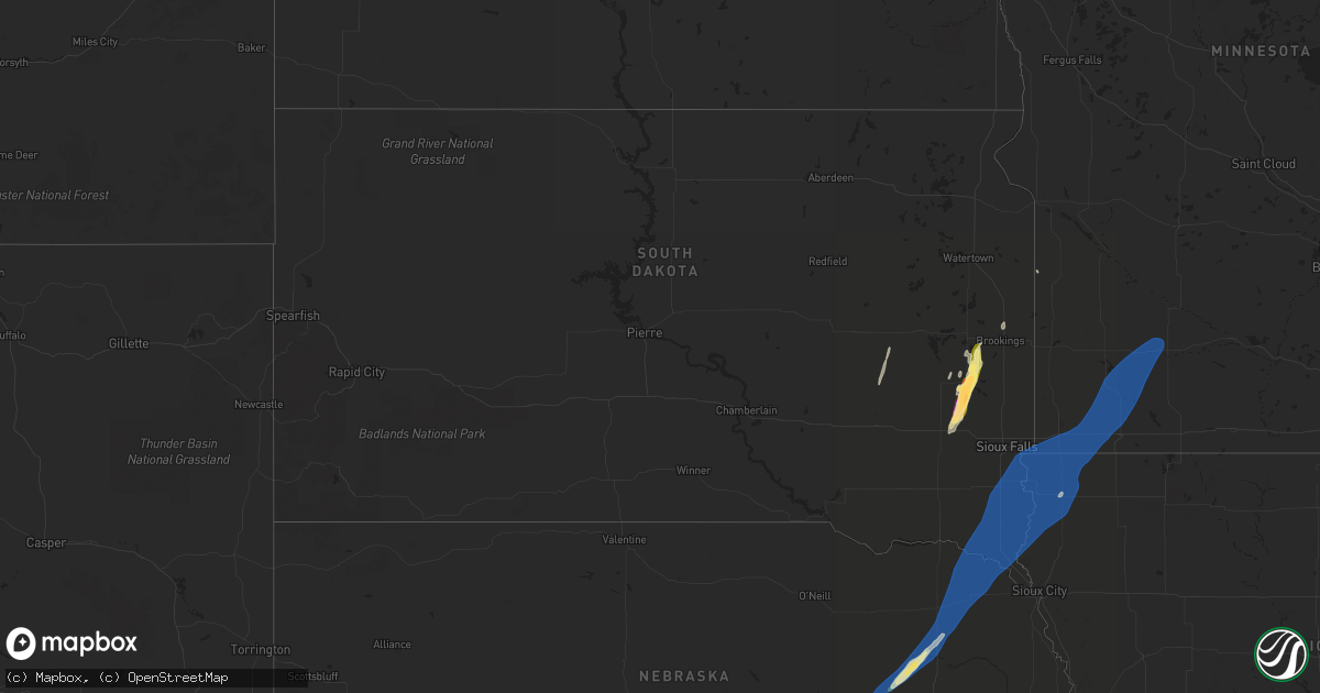
Hail Map in South Dakota on October 23, 2022
Get this storm
October 23 map
$229
one time, instant access
Download today. No call, no setup
Keep the $229
Bought the map and want the full workflow? Apply the entire $229 to a subscription within 7 days. None of it is wasted.
Every map, not just this one
This buys you this map. Subscription and you get every map we run, in the markets you choose from a few cities to whole states to nationwide. Plus real-time alerts the moment a storm fires.
Contact data
Name, contact info, occupancy, even credit band for addresses in the footprint. You go from where it hit to who to call.
Become the source they trust
Unlimited branding weather history reports on demand. You already have the documented answer ready for the property owner, and you are the one who showed up with it.
Property data and RoofTrace estimates
Pull up any address you have got, its value and the exact code rules for that jurisdiction, straight from One Click Code. Then RoofTrace estimates the squares, pitch, and roof value, priced the way you price.
Storm reports in South Dakota
South Dakota
| Date | Description |
|---|---|
| 10/23/20226:40 PM CDT | Report from mping: ping pong ball |
| 10/23/20226:40 PM CDT | Report from mping: quarter |
| 10/23/20226:39 PM CDT | Report from mping: quarter |
| 10/23/20226:39 PM CDT | Report from mping: quarter |
| 10/23/20226:33 PM CDT | A local report indicates 1.00 inch wind near 2 E MADISON |
| 10/23/20226:25 PM CDT | Social media picture. |
| 10/23/20222:56 AM CDT | At 755 PM CDT, a severe thunderstorm was located over Bruce, or 9 miles northwest of Brookings, moving north at 70 mph. HAZARD...60 mph wind gusts and quarter size hail. SOURCE...Radar indicated. IMPACT...Hail damage to vehicles is expected. Expect wind damage to roofs, siding, and trees. This severe thunderstorm will be near... White around 800 PM CDT. |
| 10/23/20222:16 AM CDT | At 715 PM CDT, a severe thunderstorm was located over Hawarden, moving northeast at 55 mph. HAZARD...70 mph wind gusts. SOURCE... Mesonet. SDSU mesonet reported a 63 mph gust at approximately 7:02 CDT. IMPACT...Expect considerable tree damage. Damage is likely to mobile homes, roofs, and outbuildings. This severe thunderstorm will be near... Ireton around 720 PM CDT. Hudson and Newton Hills State Park around 725 PM CDT. Sioux Center, Canton and Fairview around 730 PM CDT. Rock Valley and Inwood around 735 PM CDT.Other locations in the path of this severe thunderstorm include Hull,Doon, Alvord, Larchwood, Lester, Rock Rapids, George and Little Rock. |
| 10/23/20221:42 AM CDT | At 641 PM CDT, a severe thunderstorm was located near Madison, moving northeast at 45 mph. HAZARD...60 mph wind gusts and half dollar size hail. SOURCE...Radar indicated. IMPACT...Hail damage to vehicles is expected. Expect wind damage to roofs, siding, and trees. This severe thunderstorm will be near... Nunda around 655 PM CDT. Sinai around 700 PM CDT.Other locations in the path of this severe thunderstorm includeArlington, Brookings, Volga, Oakwood State Park, Bruce and White. |
| 10/23/20221:29 AM CDT | At 628 PM CDT, a severe thunderstorm was located over Laurel, or 13 miles north of Wayne, moving northeast at 55 mph. HAZARD...60 mph wind gusts. SOURCE...Radar indicated. IMPACT...Expect damage to roofs, siding, and trees. This severe thunderstorm will be near... Allen around 635 PM CDT. Martinsburg around 640 PM CDT. Maskell around 645 PM CDT.Other locations in the path of this severe thunderstorm includePonca, Newcastle, Vermillion, North Sioux City, Elk Point, PoncaState Park, Jefferson, Union Grove State Park and Akron. |
| 10/23/20221:15 AM CDT | At 615 PM CDT, a severe thunderstorm was located 10 miles west of Carthage, or 18 miles southeast of Huron, moving north at 45 mph. HAZARD...60 mph wind gusts and quarter size hail. SOURCE...Radar indicated. IMPACT...Hail damage to vehicles is expected. Expect wind damage to roofs, siding, and trees. This severe thunderstorm will be near... Iroquois and Yale around 635 PM CDT.Other locations in the path of this severe thunderstorm include DeSmet. |
| 10/23/20221:07 AM CDT | At 606 PM CDT, a severe thunderstorm was located near Montrose, or 11 miles north of Lake Vermillion State Recreation Area, moving northeast at 55 mph. HAZARD...60 mph wind gusts and half dollar size hail. SOURCE...Radar indicated. IMPACT...Hail damage to vehicles is expected. Expect wind damage to roofs, siding, and trees. This severe thunderstorm will be near... Orland around 615 PM CDT. Madison, Lake Herman State Park and Chester around 625 PM CDT.Other locations in the path of this severe thunderstorm includeRamona, Wentworth and Colman. |
| 10/22/20227:06 PM CDT | Mesonet station 16 sd rwis beresford. |
| 10/22/20227:02 PM CDT | Mesonet station bfms2 beresford 7 wsw |
All States Impacted by Hail Map on October 23, 2022
Cities Impacted by Hail Map on October 23, 2022
- Brookings, SD
- Nunda, SD
- Madison, SD
- Rock Valley, IA
- Hull, IA
- Newman Grove, NE
- Meadow Grove, NE
- Pierce, NE
- Hoskins, NE
- Albion, NE
- Madison, NE
- Norfolk, NE
- Battle Creek, NE
- Ramona, SD
- Delphos, KS
- Volga, SD
- Arlington, SD
- Sinai, SD
- Canistota, SD
- Wentworth, SD
- Salem, SD
- Montrose, SD
- Rutland, SD
- Marietta, MN
- Canby, MN
- Iroquois, SD
- Artesian, SD
- White, SD
- Aurora, SD
- Colton, SD
- Sioux Center, IA
- Maskell, NE
- Ireton, IA
- Fairview, SD
- Hawarden, IA
- Centerville, SD
- George, IA
- Wynot, NE
- Larchwood, IA
- Hartington, NE
- Primrose, NE
- Luverne, MN
- Avoca, MN
- Walnut Grove, MN
- Reading, MN
- Alcester, SD
- Kanaranzi, MN
- Maurice, IA
- Wilmont, MN
- Belden, NE
- Vermillion, SD
- Tilden, NE
- Allen, NE
- Elk Point, SD
- Kenneth, MN
- Lamberton, MN
- Doon, IA
- Dixon, NE
- Canton, SD
- Storden, MN
- Worthington, MN
- Coleridge, NE
- Dovray, MN
- Hudson, SD
- Revere, MN
- Lismore, MN
- Burbank, SD
- Slayton, MN
- Beresford, SD
- Wanda, MN
- Iona, MN
- Petersburg, NE
- Orange City, IA
- Valley Springs, SD
- Boyden, IA
- Beaver Creek, MN
- Brewster, MN
- Winside, NE
- Wolbach, NE
- Laurel, NE
- Lennox, SD
- Alvord, IA
- Ponca, NE
- Wakonda, SD
- Sanborn, MN
- Steen, MN
- Westfield, IA
- Westbrook, MN
- Sioux Falls, SD
- Lester, IA
- Worthing, SD
- Rushmore, MN
- Cedar Rapids, NE
- Rock Rapids, IA
- Harrisburg, SD
- Randolph, NE
- Carroll, NE
- Gayville, SD
- Currie, MN
- Brandon, SD
- Little Rock, IA
- Magnolia, MN
- Tracy, MN
- Newcastle, NE
- Akron, IA
- Fulda, MN
- Adrian, MN
- Inwood, IA
- Chatsworth, IA
- Ellsworth, MN
- Hills, MN
- Volin, SD


