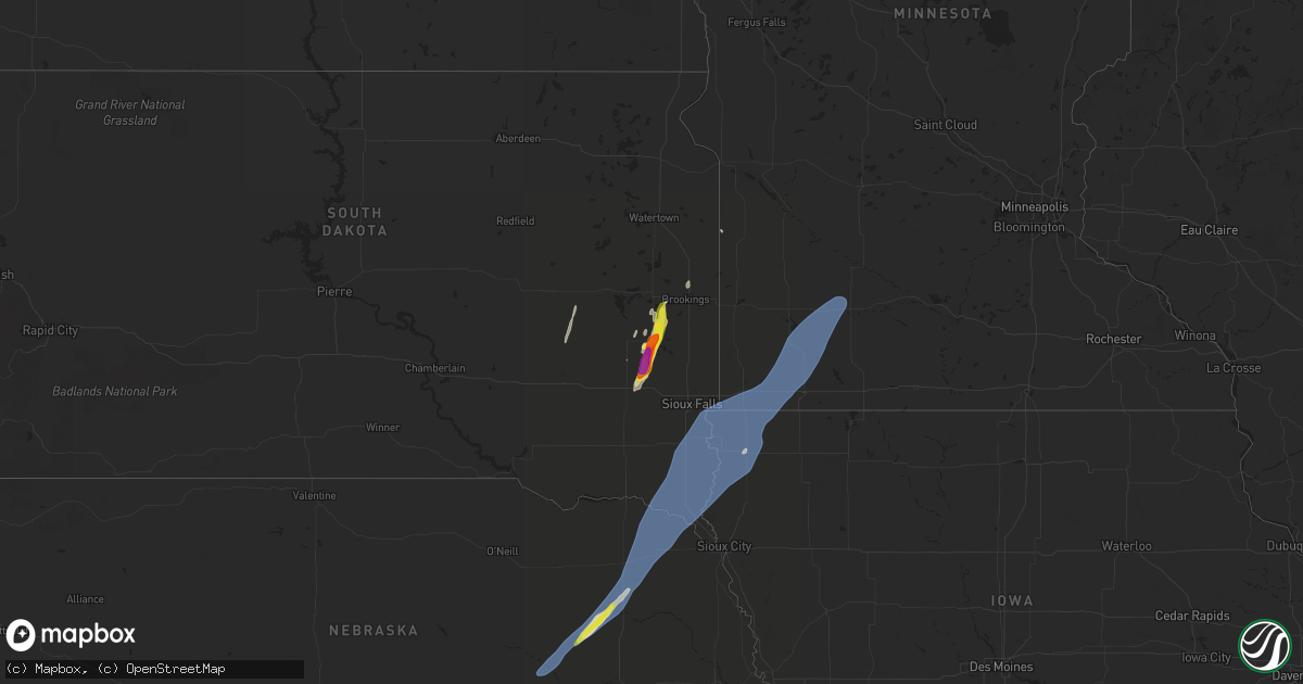
Hail Map on October 23, 2022
Get this storm
October 23 map
$229
one time, instant access
Download today. No call, no setup
Keep the $229
Bought the map and want the full workflow? Apply the entire $229 to a subscription within 7 days. None of it is wasted.
Every map, not just this one
This buys you this map. Subscription and you get every map we run, in the markets you choose from a few cities to whole states to nationwide. Plus real-time alerts the moment a storm fires.
Contact data
Name, contact info, occupancy, even credit band for addresses in the footprint. You go from where it hit to who to call.
Become the source they trust
Unlimited branding weather history reports on demand. You already have the documented answer ready for the property owner, and you are the one who showed up with it.
Property data and RoofTrace estimates
Pull up any address you have got, its value and the exact code rules for that jurisdiction, straight from One Click Code. Then RoofTrace estimates the squares, pitch, and roof value, priced the way you price.
States Impacted by Hail Map on October 23, 2022
Storm reports
South Dakota
| Date | Description |
|---|---|
| 10/23/20226:40 PM CDT | Report from mping: quarter |
| 10/23/20226:40 PM CDT | Report from mping: ping pong ball |
| 10/23/20226:39 PM CDT | Report from mping: quarter |
| 10/23/20226:39 PM CDT | Report from mping: quarter |
| 10/23/20226:33 PM CDT | A local report indicates 1.00 inch wind near 2 E MADISON |
| 10/23/20226:25 PM CDT | Social media picture. |
| 10/23/20222:56 AM CDT | At 755 PM CDT, a severe thunderstorm was located over Bruce, or 9 miles northwest of Brookings, moving north at 70 mph. HAZARD...60 mph wind gusts and quarter size hail. SOURCE...Radar indicated. IMPACT...Hail damage to vehicles is expected. Expect wind damage to roofs, siding, and trees. This severe thunderstorm will be near... White around 800 PM CDT. |
| 10/23/20222:16 AM CDT | At 715 PM CDT, a severe thunderstorm was located over Hawarden, moving northeast at 55 mph. HAZARD...70 mph wind gusts. SOURCE... Mesonet. SDSU mesonet reported a 63 mph gust at approximately 7:02 CDT. IMPACT...Expect considerable tree damage. Damage is likely to mobile homes, roofs, and outbuildings. This severe thunderstorm will be near... Ireton around 720 PM CDT. Hudson and Newton Hills State Park around 725 PM CDT. Sioux Center, Canton and Fairview around 730 PM CDT. Rock Valley and Inwood around 735 PM CDT.Other locations in the path of this severe thunderstorm include Hull,Doon, Alvord, Larchwood, Lester, Rock Rapids, George and Little Rock. |
| 10/23/20221:42 AM CDT | At 641 PM CDT, a severe thunderstorm was located near Madison, moving northeast at 45 mph. HAZARD...60 mph wind gusts and half dollar size hail. SOURCE...Radar indicated. IMPACT...Hail damage to vehicles is expected. Expect wind damage to roofs, siding, and trees. This severe thunderstorm will be near... Nunda around 655 PM CDT. Sinai around 700 PM CDT.Other locations in the path of this severe thunderstorm includeArlington, Brookings, Volga, Oakwood State Park, Bruce and White. |
| 10/23/20221:29 AM CDT | At 628 PM CDT, a severe thunderstorm was located over Laurel, or 13 miles north of Wayne, moving northeast at 55 mph. HAZARD...60 mph wind gusts. SOURCE...Radar indicated. IMPACT...Expect damage to roofs, siding, and trees. This severe thunderstorm will be near... Allen around 635 PM CDT. Martinsburg around 640 PM CDT. Maskell around 645 PM CDT.Other locations in the path of this severe thunderstorm includePonca, Newcastle, Vermillion, North Sioux City, Elk Point, PoncaState Park, Jefferson, Union Grove State Park and Akron. |
| 10/23/20221:15 AM CDT | At 615 PM CDT, a severe thunderstorm was located 10 miles west of Carthage, or 18 miles southeast of Huron, moving north at 45 mph. HAZARD...60 mph wind gusts and quarter size hail. SOURCE...Radar indicated. IMPACT...Hail damage to vehicles is expected. Expect wind damage to roofs, siding, and trees. This severe thunderstorm will be near... Iroquois and Yale around 635 PM CDT.Other locations in the path of this severe thunderstorm include DeSmet. |
| 10/23/20221:07 AM CDT | At 606 PM CDT, a severe thunderstorm was located near Montrose, or 11 miles north of Lake Vermillion State Recreation Area, moving northeast at 55 mph. HAZARD...60 mph wind gusts and half dollar size hail. SOURCE...Radar indicated. IMPACT...Hail damage to vehicles is expected. Expect wind damage to roofs, siding, and trees. This severe thunderstorm will be near... Orland around 615 PM CDT. Madison, Lake Herman State Park and Chester around 625 PM CDT.Other locations in the path of this severe thunderstorm includeRamona, Wentworth and Colman. |
| 10/22/20227:06 PM CDT | Mesonet station 16 sd rwis beresford. |
| 10/22/20227:02 PM CDT | Mesonet station bfms2 beresford 7 wsw |
Minnesota
| Date | Description |
|---|---|
| 10/23/20223:46 AM CDT | At 846 PM CDT, a severe thunderstorm was located near Lamberton, or 22 miles north of Windom, moving northeast at 75 mph. HAZARD...60 mph wind gusts. SOURCE...Radar indicated. IMPACT...Expect damage to roofs, siding, and trees. This severe thunderstorm will be near... Springfield around 855 PM CDT. Morgan around 905 PM CDT. |
| 10/23/20223:20 AM CDT | At 820 PM CDT, severe thunderstorms were located along a line extending from near Chandler to Fulda to near Worthington, moving northeast at 75 mph. HAZARD...60 mph wind gusts. SOURCE...Radar indicated. IMPACT...Expect damage to roofs, siding, and trees. Severe thunderstorms will be near... Lakefield, Westbrook, Currie and Lake Shetek State Park around 830 PM CDT. Heron Lake, Storden and Dovray around 835 PM CDT. Windom around 840 PM CDT.Other locations in the path of these severe thunderstorms includeJeffers, Bingham Lake, Mountain Lake and Comfrey. |
| 10/22/20229:13 PM CDT | A local report indicates 62 MPH wind near 1 SSE NORTH REDWOOD |
| 10/22/20228:32 PM CDT | Mesonet station mn038 t.h.30 - dovray - mp 49. |
| 10/22/20228:02 PM CDT | Leaves plastered on side of house. Wind knocked out power. |
| 10/22/20227:52 PM CDT | Mesonet station mn147 i-90 - magnolia - mp 21.6. |
Nebraska
| Date | Description |
|---|---|
| 10/23/20226:42 PM CDT | A local report indicates 60 MPH wind near 4 SSW NEWCASTLE |
| 10/23/20226:22 PM CDT | Personal weather station. |
| 10/23/20226:20 PM CDT | Personal weather station. |
| 10/23/20226:01 PM CDT | Personal weather station. |
| 10/23/20225:45 PM CDT | Grain bin destroyed. |
| 10/23/20225:40 PM CDT | Multiple vehicles damaged. |
| 10/23/20225:25 PM CDT | Downed limbs hit and damaged car. |
| 10/23/20225:04 PM CDT | A local report indicates 58 MPH wind near 4 NW ALBION |
| 10/23/20224:53 PM CDT | A local report indicates 61 MPH wind near 1 NNW CEDAR RAPIDS |
| 10/23/20221:13 AM CDT | At 611 PM CDT, a severe thunderstorm was located 6 miles northwest of Winside, or 14 miles northeast of Norfolk, moving northeast at 55 mph. HAZARD...60 mph wind gusts and half dollar size hail. SOURCE...Public. At 540 PM, half dollar size hail was reported by the public 4 miles south of Meadow Grove. IMPACT...Hail damage to vehicles is expected. Expect wind damage to roofs, siding, and trees. This severe thunderstorm will be near... Winside around 615 PM CDT. Carroll around 620 PM CDT. Belden around 625 PM CDT. Laurel around 630 PM CDT. |
| 10/23/202212:42 AM CDT | At 541 PM CDT, a severe thunderstorm was located over Battle Creek, or 10 miles west of Norfolk, moving northeast at 65 mph. HAZARD...60 mph wind gusts and up to quarter size hail. SOURCE...Radar indicated. IMPACT...Hail damage to vehicles is expected. Expect wind damage to roofs, siding, and trees. This severe thunderstorm will be near... Norfolk and Hadar around 550 PM CDT. Pierce and Hoskins around 555 PM CDT.Other locations in the path of this severe thunderstorm includeRandolph and Carroll. |
| 10/23/202212:10 AM CDT | At 509 PM CDT, a severe thunderstorm was located 8 miles northwest of Newman Grove, or 12 miles northeast of Albion, moving northeast at 60 mph. HAZARD...70 mph wind gusts. SOURCE...Radar indicated. At 508 PM, winds of 58 mph was reported Albion airport. IMPACT...Expect considerable tree damage. Damage is likely to mobile homes, roofs, and outbuildings. This severe thunderstorm will be near... Battle Creek, Tilden and Meadow Grove around 525 PM CDT.Other locations in the path of this severe thunderstorm includePierce. |
| 10/22/202211:38 PM CDT | At 437 PM CDT, a severe thunderstorm was located 3 miles southwest of Cedar Rapids, or 15 miles southwest of Albion, moving northeast at 60 mph. HAZARD...70 mph wind gusts. SOURCE...Radar indicated. IMPACT...Expect considerable tree damage. Damage is likely to mobile homes, roofs, and outbuildings. This severe thunderstorm will be near... Albion around 455 PM CDT. |
| 10/22/202211:27 PM CDT | At 426 PM CDT, severe thunderstorms were located along a line extending from near Wolbach to near Farwell to 8 miles southeast of Poole, moving northeast at 55 mph. HAZARD...70 mph wind gusts. SOURCE...Radar indicated. IMPACT...Expect considerable tree damage. Damage is likely to mobile homes, roofs, and outbuildings. Locations impacted include... St. Paul, Cairo, Dannebrog, Wolbach, Elba, Farwell, Cushing and Boelus. |
Kansas
| Date | Description |
|---|---|
| 10/23/202212:19 AM CDT | At 519 PM CDT, a severe thunderstorm was located near Tipton, or 15 miles southwest of Beloit, moving northeast at 55 mph. HAZARD...60 mph wind gusts. SOURCE...Radar indicated. IMPACT...Expect damage to roofs, siding, and trees. Locations impacted include... Beloit, Mankato, Glen Elder, Jewell, Tipton, Formoso, Randall, Hunter, Webber, Scottsville, Victor, Lovewell State Park and Montrose. |
| 10/22/202211:42 PM CDT | A local report indicates 59 MPH wind near 3 E HUTCHINSON |
Iowa
| Date | Description |
|---|---|
| 10/23/20224:50 PM CDT | Branches down measuring around 1 to 2 inches with the passing storm. |
| 10/23/20222:47 AM CDT | At 746 PM CDT, a severe thunderstorm was located near Ellsworth, or near Rock Rapids, moving northeast at 80 mph. HAZARD...60 mph wind gusts. SOURCE...Trained spotter reported 3 inch branch down near Doon, IA. IMPACT...Expect damage to roofs, siding, and trees. This severe thunderstorm will be near... Adrian and Blue Mounds State Park around 755 PM CDT. Rushmore and Lismore around 800 PM CDT. Worthington, Leota and Wilmont around 805 PM CDT.Other locations in the path of this severe thunderstorm includeChandler and Fulda. |
| 10/22/20227:40 PM CDT | Personal weather station. |
| 10/22/20227:31 PM CDT | 3 inch diameter tree branches downed by thunderstorm wind. Estimated 60 mph. |
| 10/22/20227:25 PM CDT | Report from mping: 1-inch tree limbs broken; shingles blown off. |
Cities Impacted by Hail Map on October 23, 2022
- Brookings, SD
- Nunda, SD
- Madison, SD
- Rock Valley, IA
- Hull, IA
- Newman Grove, NE
- Meadow Grove, NE
- Pierce, NE
- Hoskins, NE
- Albion, NE
- Madison, NE
- Norfolk, NE
- Battle Creek, NE
- Ramona, SD
- Delphos, KS
- Volga, SD
- Arlington, SD
- Sinai, SD
- Canistota, SD
- Wentworth, SD
- Salem, SD
- Montrose, SD
- Rutland, SD
- Marietta, MN
- Canby, MN
- Iroquois, SD
- Artesian, SD
- White, SD
- Aurora, SD
- Colton, SD
- Sioux Center, IA
- Maskell, NE
- Ireton, IA
- Fairview, SD
- Hawarden, IA
- Centerville, SD
- George, IA
- Wynot, NE
- Larchwood, IA
- Hartington, NE
- Primrose, NE
- Luverne, MN
- Avoca, MN
- Walnut Grove, MN
- Reading, MN
- Alcester, SD
- Kanaranzi, MN
- Maurice, IA
- Wilmont, MN
- Belden, NE
- Vermillion, SD
- Tilden, NE
- Allen, NE
- Elk Point, SD
- Kenneth, MN
- Lamberton, MN
- Doon, IA
- Dixon, NE
- Canton, SD
- Storden, MN
- Worthington, MN
- Coleridge, NE
- Dovray, MN
- Hudson, SD
- Revere, MN
- Lismore, MN
- Burbank, SD
- Slayton, MN
- Beresford, SD
- Wanda, MN
- Iona, MN
- Petersburg, NE
- Orange City, IA
- Valley Springs, SD
- Boyden, IA
- Beaver Creek, MN
- Brewster, MN
- Winside, NE
- Wolbach, NE
- Laurel, NE
- Lennox, SD
- Alvord, IA
- Ponca, NE
- Wakonda, SD
- Sanborn, MN
- Steen, MN
- Westfield, IA
- Westbrook, MN
- Sioux Falls, SD
- Lester, IA
- Worthing, SD
- Rushmore, MN
- Cedar Rapids, NE
- Rock Rapids, IA
- Harrisburg, SD
- Randolph, NE
- Carroll, NE
- Gayville, SD
- Currie, MN
- Brandon, SD
- Little Rock, IA
- Magnolia, MN
- Tracy, MN
- Newcastle, NE
- Akron, IA
- Fulda, MN
- Adrian, MN
- Inwood, IA
- Chatsworth, IA
- Ellsworth, MN
- Hills, MN
- Volin, SD