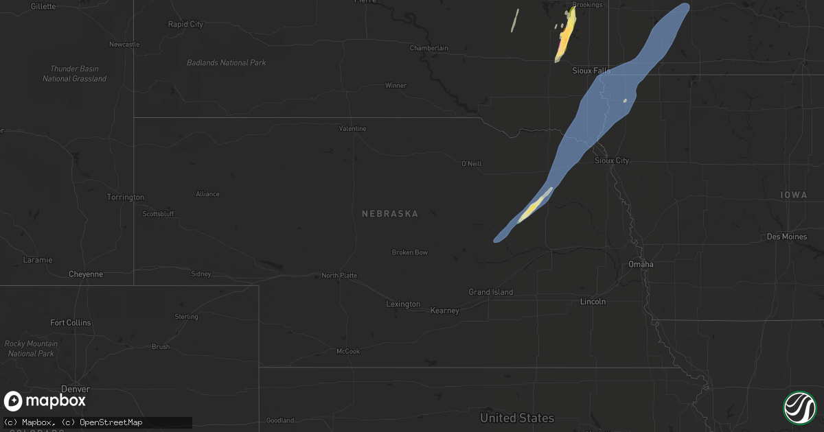
Hail Map in Nebraska on October 23, 2022
Get this storm
October 23 map
$229
one time, instant access
Download today. No call, no setup
Keep the $229
Bought the map and want the full workflow? Apply the entire $229 to a subscription within 7 days. None of it is wasted.
Every map, not just this one
This buys you this map. Subscription and you get every map we run, in the markets you choose from a few cities to whole states to nationwide. Plus real-time alerts the moment a storm fires.
Contact data
Name, contact info, occupancy, even credit band for addresses in the footprint. You go from where it hit to who to call.
Become the source they trust
Unlimited branding weather history reports on demand. You already have the documented answer ready for the property owner, and you are the one who showed up with it.
Property data and RoofTrace estimates
Pull up any address you have got, its value and the exact code rules for that jurisdiction, straight from One Click Code. Then RoofTrace estimates the squares, pitch, and roof value, priced the way you price.
Storm reports in Nebraska
Nebraska
| Date | Description |
|---|---|
| 10/23/20226:42 PM CDT | A local report indicates 60 MPH wind near 4 SSW NEWCASTLE |
| 10/23/20226:22 PM CDT | Personal weather station. |
| 10/23/20226:20 PM CDT | Personal weather station. |
| 10/23/20226:01 PM CDT | Personal weather station. |
| 10/23/20225:45 PM CDT | Grain bin destroyed. |
| 10/23/20225:40 PM CDT | Multiple vehicles damaged. |
| 10/23/20225:25 PM CDT | Downed limbs hit and damaged car. |
| 10/23/20225:04 PM CDT | A local report indicates 58 MPH wind near 4 NW ALBION |
| 10/23/20224:53 PM CDT | A local report indicates 61 MPH wind near 1 NNW CEDAR RAPIDS |
| 10/23/20221:13 AM CDT | At 611 PM CDT, a severe thunderstorm was located 6 miles northwest of Winside, or 14 miles northeast of Norfolk, moving northeast at 55 mph. HAZARD...60 mph wind gusts and half dollar size hail. SOURCE...Public. At 540 PM, half dollar size hail was reported by the public 4 miles south of Meadow Grove. IMPACT...Hail damage to vehicles is expected. Expect wind damage to roofs, siding, and trees. This severe thunderstorm will be near... Winside around 615 PM CDT. Carroll around 620 PM CDT. Belden around 625 PM CDT. Laurel around 630 PM CDT. |
| 10/23/202212:42 AM CDT | At 541 PM CDT, a severe thunderstorm was located over Battle Creek, or 10 miles west of Norfolk, moving northeast at 65 mph. HAZARD...60 mph wind gusts and up to quarter size hail. SOURCE...Radar indicated. IMPACT...Hail damage to vehicles is expected. Expect wind damage to roofs, siding, and trees. This severe thunderstorm will be near... Norfolk and Hadar around 550 PM CDT. Pierce and Hoskins around 555 PM CDT.Other locations in the path of this severe thunderstorm includeRandolph and Carroll. |
| 10/23/202212:10 AM CDT | At 509 PM CDT, a severe thunderstorm was located 8 miles northwest of Newman Grove, or 12 miles northeast of Albion, moving northeast at 60 mph. HAZARD...70 mph wind gusts. SOURCE...Radar indicated. At 508 PM, winds of 58 mph was reported Albion airport. IMPACT...Expect considerable tree damage. Damage is likely to mobile homes, roofs, and outbuildings. This severe thunderstorm will be near... Battle Creek, Tilden and Meadow Grove around 525 PM CDT.Other locations in the path of this severe thunderstorm includePierce. |
| 10/22/202211:38 PM CDT | At 437 PM CDT, a severe thunderstorm was located 3 miles southwest of Cedar Rapids, or 15 miles southwest of Albion, moving northeast at 60 mph. HAZARD...70 mph wind gusts. SOURCE...Radar indicated. IMPACT...Expect considerable tree damage. Damage is likely to mobile homes, roofs, and outbuildings. This severe thunderstorm will be near... Albion around 455 PM CDT. |
| 10/22/202211:27 PM CDT | At 426 PM CDT, severe thunderstorms were located along a line extending from near Wolbach to near Farwell to 8 miles southeast of Poole, moving northeast at 55 mph. HAZARD...70 mph wind gusts. SOURCE...Radar indicated. IMPACT...Expect considerable tree damage. Damage is likely to mobile homes, roofs, and outbuildings. Locations impacted include... St. Paul, Cairo, Dannebrog, Wolbach, Elba, Farwell, Cushing and Boelus. |
All States Impacted by Hail Map on October 23, 2022
Cities Impacted by Hail Map on October 23, 2022
- Brookings, SD
- Nunda, SD
- Madison, SD
- Rock Valley, IA
- Hull, IA
- Newman Grove, NE
- Meadow Grove, NE
- Pierce, NE
- Hoskins, NE
- Albion, NE
- Madison, NE
- Norfolk, NE
- Battle Creek, NE
- Ramona, SD
- Delphos, KS
- Volga, SD
- Arlington, SD
- Sinai, SD
- Canistota, SD
- Wentworth, SD
- Salem, SD
- Montrose, SD
- Rutland, SD
- Marietta, MN
- Canby, MN
- Iroquois, SD
- Artesian, SD
- White, SD
- Aurora, SD
- Colton, SD
- Sioux Center, IA
- Maskell, NE
- Ireton, IA
- Fairview, SD
- Hawarden, IA
- Centerville, SD
- George, IA
- Wynot, NE
- Larchwood, IA
- Hartington, NE
- Primrose, NE
- Luverne, MN
- Avoca, MN
- Walnut Grove, MN
- Reading, MN
- Alcester, SD
- Kanaranzi, MN
- Maurice, IA
- Wilmont, MN
- Belden, NE
- Vermillion, SD
- Tilden, NE
- Allen, NE
- Elk Point, SD
- Kenneth, MN
- Lamberton, MN
- Doon, IA
- Dixon, NE
- Canton, SD
- Storden, MN
- Worthington, MN
- Coleridge, NE
- Dovray, MN
- Hudson, SD
- Revere, MN
- Lismore, MN
- Burbank, SD
- Slayton, MN
- Beresford, SD
- Wanda, MN
- Iona, MN
- Petersburg, NE
- Orange City, IA
- Valley Springs, SD
- Boyden, IA
- Beaver Creek, MN
- Brewster, MN
- Winside, NE
- Wolbach, NE
- Laurel, NE
- Lennox, SD
- Alvord, IA
- Ponca, NE
- Wakonda, SD
- Sanborn, MN
- Steen, MN
- Westfield, IA
- Westbrook, MN
- Sioux Falls, SD
- Lester, IA
- Worthing, SD
- Rushmore, MN
- Cedar Rapids, NE
- Rock Rapids, IA
- Harrisburg, SD
- Randolph, NE
- Carroll, NE
- Gayville, SD
- Currie, MN
- Brandon, SD
- Little Rock, IA
- Magnolia, MN
- Tracy, MN
- Newcastle, NE
- Akron, IA
- Fulda, MN
- Adrian, MN
- Inwood, IA
- Chatsworth, IA
- Ellsworth, MN
- Hills, MN
- Volin, SD


