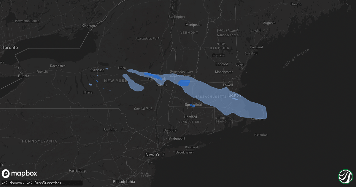
Hail Map in Massachusetts on October 7, 2020
Get this storm
October 7 map
$229
one time, instant access
Download today. No call, no setup
Keep the $229
Bought the map and want the full workflow? Apply the entire $229 to a subscription within 7 days. None of it is wasted.
Every map, not just this one
This buys you this map. Subscription and you get every map we run, in the markets you choose from a few cities to whole states to nationwide. Plus real-time alerts the moment a storm fires.
Contact data
Name, contact info, occupancy, even credit band for addresses in the footprint. You go from where it hit to who to call.
Become the source they trust
Unlimited branding weather history reports on demand. You already have the documented answer ready for the property owner, and you are the one who showed up with it.
Property data and RoofTrace estimates
Pull up any address you have got, its value and the exact code rules for that jurisdiction, straight from One Click Code. Then RoofTrace estimates the squares, pitch, and roof value, priced the way you price.
Storm reports in Massachusetts
Massachusetts
| Date | Description |
|---|---|
| 10/07/20206:41 PM CDT | A local report indicates 60 MPH wind near NANTUCKET AP |
| 10/07/20206:13 PM CDT | A local report indicates 64 MPH wind near DENNIS |
| 10/07/20205:52 PM CDT | West island |
| 10/07/20205:45 PM CDT | A local report indicates 63 MPH wind near 9 WNW TRURO |
| 10/07/20205:35 PM CDT | A local report indicates 82 MPH wind near QUINCY |
| 10/07/20205:33 PM CDT | A local report indicates 60 MPH wind near PLYMOUTH AP |
| 10/07/20205:32 PM CDT | Redwood dr - tree down on wires - wires smoking |
| 10/07/20205:31 PM CDT | Multiple trees down on south street between foxborough high school and taylor school south. Street closed |
| 10/07/20205:19 PM CDT | Prospect st - large 10 inch diameter branch blocking traffic. Top half of tree down on marion st |
| 10/07/20205:17 PM CDT | Tree down at cambridge terrace |
| 10/07/20205:12 PM CDT | Trees down in the feedinghills section |
| 10/07/20205:12 PM CDT | A local report indicates 65 MPH wind near HINGHAM |
| 10/07/20205:05 PM CDT | Resident from braintree reported a 64 mph wind gust with their anemometer at about 0605 pm on 10/7. Damage in the immediate area was mostly downed tree limbs. |
| 10/07/20205:05 PM CDT | Multiple trees down... Snapped... Or uprooted from mill brook drive to pine brook drive. Four trees were downed on houses. |
| 10/07/20205:02 PM CDT | A local report indicates 68 MPH wind near BLUE HILL ASOS |
| 10/07/20205:01 PM CDT | A local report indicates 58 MPH wind near WRENTHAM |
| 10/07/20205:01 PM CDT | A local report indicates 58 MPH wind near NORWOOD AP |
| 10/07/20205:00 PM CDT | A local report indicates 66 MPH wind near LOGAN AP |
| 10/07/20205:00 PM CDT | Tree uprooted and tree split in half on wright rd in west concord. Telephone pole down at lawsbrook rd |
| 10/07/20205:00 PM CDT | Multiple trees down on laurel dr |
| 10/07/20204:55 PM CDT | Tree down on mountain view road |
| 10/07/20204:55 PM CDT | Multiple trees down around south street |
| 10/07/20204:53 PM CDT | A local report indicates 58 MPH wind near MENDON |
| 10/07/20204:50 PM CDT | Tree down blocking school st |
| 10/07/20204:50 PM CDT | Nws survey found ef-0 tornado in millis... Ma on ground for less than 1 minute... With path length of 1/2 mile... Width 50 yards... And maximum speed of 75-80 mph. Bega |
| 10/07/20204:46 PM CDT | Small tree down on brockelman rd |
| 10/07/20204:45 PM CDT | Multiple trees and wires down across town |
| 10/07/20204:45 PM CDT | Teacher from norfolk county agricultural high school in walpole reported that nearly 100 tree went down with the storm last night around 5:45 pm. |
| 10/07/20204:45 PM CDT | North grafton... Tree down at frances/jay st. |
| 10/07/20204:45 PM CDT | Multiple trees down at 196 worcester road |
| 10/07/20204:45 PM CDT | Tree down on house; on anthony st... On third st... And tree blocking loveland st |
| 10/07/20204:45 PM CDT | Tree and wires down on ash st. Large branch one foot in diameter down on milk st with wires down. |
| 10/07/20204:40 PM CDT | Trees down on colonial st - road blocked |
| 10/07/20204:40 PM CDT | Trees snapped on green st |
| 10/07/20204:40 PM CDT | Multiple trees/wires down with road closures on tuttle... Kilburn... & north row road |
| 10/07/20204:37 PM CDT | A local report indicates 60 MPH wind near HUDSON |
| 10/07/20204:35 PM CDT | Tree on garage/truck at westernview circle. |
| 10/07/20204:30 PM CDT | Tree limbs down across the city; beechmont st [limb on house]... Brantwood rd... Pleasant st [limb on house]... Dayton st... Main st... Varnum st... June st... Maxwell |
| 10/07/20204:30 PM CDT | Multiple reports of trees down; ed holcomb rd... Hillside rd ranch golf club... Jerry drive... Miller rd... Hillside rd wires down... Southwick acres campground |
| 10/07/20204:27 PM CDT | *** 5 inj *** devens fire chief reported 5 injuries from ft. Devens when a military-grade tent was blown over by thunderstorm winds. The 5 injured were taken to the hos |
| 10/07/20204:27 PM CDT | A local report indicates 70 MPH wind near WORCESTER AP |
| 10/07/20204:26 PM CDT | Reports of numerous trees down across agawam |
| 10/07/20204:24 PM CDT | A local report indicates 60 MPH wind near FITCHBURG AP |
| 10/07/20204:24 PM CDT | Liberty st - tree down |
| 10/07/20204:21 PM CDT | River run road - tree down across road with wires down |
| 10/07/20204:20 PM CDT | Downed trees and wires |
| 10/07/20204:16 PM CDT | Downed tree |
| 10/07/20204:15 PM CDT | Tree and wires down on birchland ave. Tree split and landed on house on jeffery road. |
| 10/07/20204:15 PM CDT | Numerous trees down on route 141 |
| 10/07/20204:13 PM CDT | A local report indicates 74 MPH wind near WESTFIELD-BARNES AP |
| 10/07/20204:11 PM CDT | A local report indicates 63 MPH wind near WESTOVER AFB |
| 10/07/20204:10 PM CDT | Northampton road just east of dana - tree down blocking road |
| 10/07/20204:09 PM CDT | Pleasant street - tree and wires down |
| 10/07/20204:05 PM CDT | Powerline down on car on lyman st |
| 10/07/20204:03 PM CDT | Route 112 - tree down |
| 10/07/20204:03 PM CDT | Tree down on car at 47 florence road |
| 10/07/20204:02 PM CDT | Observation from a mesonet site. |
| 10/07/20204:00 PM CDT | Large tree blocking route 10 about 1/2 mile north of union st |
| 10/07/20204:00 PM CDT | Tree down on three cars on pine street |
| 10/07/20203:58 PM CDT | Multiple trees down on i-91 in whately and deerfield - roadway is blocked |
| 10/07/20203:55 PM CDT | *** 1 fatal *** trees down on man in golf cart on wyantenuck golf course. Time estimated. |
| 10/07/20203:54 PM CDT | 392 chesterfield road - tree down blocking road in the leeds section of northampton |
| 10/07/20203:53 PM CDT | Interstate 91 southbound - tree down on car - no injuries |
| 10/07/20203:52 PM CDT | Summit street at west street - tree and wires down |
| 10/07/20203:49 PM CDT | Hawley road - trees down |
| 10/07/20203:48 PM CDT | Parts of route 20 closed in lee due to downed trees |
| 10/07/20203:48 PM CDT | Interstate 91 southbound exit 28 off ramp - tree blocking ramp |
| 10/07/20203:48 PM CDT | Baptist hill road - tree down |
| 10/07/20203:48 PM CDT | Multiple downed trees |
| 10/07/20203:47 PM CDT | Tree down on route 116 |
| 10/07/20203:45 PM CDT | Multiple trees... Utility poles... And wires down on adamsville road and foundry |
| 10/07/20203:42 PM CDT | 24 old main road - tree and wires down |
| 10/07/20203:34 PM CDT | Large tree limb down |
| 10/07/20203:33 PM CDT | A local report indicates 60 MPH wind near PITTSFIELD MUNICIPAL AP |
| 10/07/20203:33 PM CDT | Tree and wires down on route 9 at the intersection of hill street and hill road |
| 10/07/20203:31 PM CDT | Multiple trees down |
| 10/07/20203:29 PM CDT | Multiple 3-4 inch branches down with power outages - also multiple small trees down on ford hill road. |
| 10/07/20203:25 PM CDT | Multiple trees down |
| 10/07/20203:25 PM CDT | Tree down in lanesboro near route 8 |
| 10/07/20203:21 PM CDT | Multiple trees down |
| 10/07/20203:17 PM CDT | A local report indicates 60 MPH wind near HARRIMAN-AND-WEST-AI |
| 10/07/20203:16 PM CDT | Tree down on car |
| 10/07/20201:36 AM CDT | At 635 PM EDT, severe thunderstorms were located along a line extending from 18 miles north of Provincetown to near Plymouth to near Somerset, moving east at 60 mph. HAZARD...60 mph wind gusts. SOURCE...Radar indicated. IMPACT...Expect damage to trees and power lines. Locations impacted include... New Bedford, Fall River, Plymouth, Barnstable, Dartmouth, Falmouth, Brewster, Marion, Provincetown, Yarmouth, Middleborough, Wareham, Sandwich, Bourne, Somerset, Portsmouth, Barrington, Middletown, Fairhaven and Swansea. |
| 10/07/202012:30 AM CDT | At 529 PM EDT, severe thunderstorms were located along a line extending from near Hooksett to Brookline, moving east at 65 mph. HAZARD...60 mph wind gusts. SOURCE...Radar indicated. IMPACT...Expect damage to roofs, siding, and trees. Locations impacted include... Manchester, Nashua, Derry, Hampton, Exeter, Merrimack, Salem, Bedford, Milford, Hooksett, Amherst, Litchfield, Hollis, Epping, Brentwood, Greenland, Mason, Raymond, Seabrook and Hudson.This includes the following highways... Interstate 293 between mile markers 1 and 10. Interstate 93 between mile markers 0 and 24. Interstate 95 in New Hampshire between mile markers 0 and 9.This also includes... Hampton Beach. |
| 10/06/202011:59 PM CDT | At 458 PM EDT, severe thunderstorms were located along a line extending from near Nelson to near Troy, moving east at 60 mph. HAZARD...60 mph wind gusts. SOURCE...Radar indicated. IMPACT...Expect damage to roofs, siding, and trees. Locations impacted include... Nashua, Merrimack, Jaffrey, Bedford, Milford, Amherst, Hollis, Swanzey, Peterborough, New Boston, Antrim, Mont Vernon, Greenfield, Lyndeborough, Dublin, Francestown, Bennington, Richmond, Harrisville and Nelson.This also includes... Mount Monadnock and North Pack Monadnock. |
| 10/06/202011:57 PM CDT | At 457 PM EDT, severe thunderstorms were located along a line extending from near Chester to near Great Barrington to near Sheffield to near Livingston, moving southeast at 55 mph. HAZARD...70 mph wind gusts. SOURCE...Radar indicated. IMPACT...Expect considerable tree damage. Damage is likely to mobile homes, roofs, and outbuildings. Locations impacted include... Torrington, Great Barrington, New Hartford, Copake, Sheffield, Clermont, Norfolk, Otis, Ancram, Canaan, Millerton, Sandisfield, New Hartford Center, Ashley Falls, Falls Village, Winsted, Barkhamsted, Salisbury, New Marlborough and Colebrook. |
| 10/06/202011:39 PM CDT | At 438 PM EDT, severe thunderstorms were located along a line extending from 6 miles northwest of Hinsdale to 13 miles southwest of Winchester, moving east at 70 mph. HAZARD...60 mph wind gusts. SOURCE...Radar indicated. IMPACT...Expect damage to roofs, siding, and trees. Locations impacted include... Jaffrey, Swanzey, Winchester, Richmond, Rindge, Hinsdale, Fitzwilliam, Troy and Chesterfield. |
| 10/06/202011:38 PM CDT | At 438 PM EDT, severe thunderstorms were located along a line extending from near East Windsor to near Austerlitz, moving east at 65 mph. HAZARD...60 mph wind gusts. SOURCE...Radar indicated. IMPACT...Expect damage to trees and power lines. Locations impacted include... Springfield, Chicopee, Westfield, Holyoke, Amherst, Northampton, Agawam, West Springfield, Ludlow, South Hadley, Easthampton, Longmeadow, East Longmeadow, Belchertown, Wilbraham, Palmer, Ware, Southwick, Monson and Granby. |
| 10/06/202011:13 PM CDT | At 412 PM EDT, severe thunderstorms were located along a line extending from near Shaftsbury to near Williamstown to near Nassau, moving east at 55 mph. HAZARD...70 mph wind gusts. SOURCE...Radar indicated. IMPACT...Expect considerable damage to trees and power lines. Damage is likely to mobile homes and outbuildings. Locations impacted include... Amherst, Northampton, Greenfield, Orange, Deerfield, Monroe, Montague, Hadley, Sunderland, Hatfield, Northfield, Williamsburg, Bernardston, Buckland, Conway, Shelburne, Leverett, Erving, Shutesbury and Ashfield. |
All States Impacted by Hail Map on October 7, 2020
Cities Impacted by Hail Map on October 7, 2020
- Syracuse, NY
- La Fayette, NY
- Homer, NY
- Preble, NY
- Locke, NY
- Canastota, NY
- Westford, NY
- East Worcester, NY
- Stamford, NY
- Richfield Springs, NY
- Maryland, NY
- Summit, NY
- Richmondville, NY
- Worcester, NY
- Schenevus, NY
- Davenport, NY
- Warnerville, NY
- Roseboom, NY
- West Fulton, NY
- Cooperstown, NY
- Middleburgh, NY
- Burlington Flats, NY
- West Winfield, NY
- Fly Creek, NY
- Charlotteville, NY
- Milford, NY
- Cherry Valley, NY
- Ilion, NY
- Fultonham, NY
- Jefferson, NY
- Hartwick, NY
- Glendale, RI
- Pembroke, MA
- North Bennington, VT
- Bedford, MA
- East Wareham, MA
- Watertown, MA
- Clifton Park, NY
- Providence, RI
- Douglas, MA
- Dudley, MA
- Wellesley, MA
- Ballston Lake, NY
- Turners Falls, MA
- Hudson, MA
- North Easton, MA
- New Salem, MA
- Barre, MA
- Chelmsford, MA
- Wrentham, MA
- Avon, MA
- Bolton, MA
- Wendell Depot, MA
- Rowe, MA
- Orange, MA
- Holliston, MA
- East Boston, MA
- Charlemont, MA
- South Dennis, MA
- North Adams, MA
- Shelburne Falls, MA
- Harvard, MA
- Newtonville, MA
- Mattapan, MA
- Rehoboth, MA
- Sharon, MA
- Leicester, MA
- Cohasset, MA
- Waban, MA
- Charlestown, MA
- Petersburg, NY
- Slatersville, RI
- Onset, MA
- Goshen, MA
- Bridgewater, MA
- Marlborough, MA
- Cherry Valley, MA
- Sagamore Beach, MA
- East Sandwich, MA
- Fayville, MA
- Westwood, MA
- North Weymouth, MA
- Melrose, NY
- Palmer, MA
- Haydenville, MA
- West Barnstable, MA
- Medway, MA
- Cumberland, RI
- Clinton, MA
- North Chatham, MA
- North Providence, RI
- Waltham, MA
- Newton, MA
- Stillwater, NY
- Conway, MA
- Paxton, MA
- Delanson, NY
- Northfield, MA
- Hubbardston, MA
- Webster, MA
- Norwood, MA
- Mapleville, RI
- Malden, MA
- Watervliet, NY
- Valley Falls, NY
- Rexford, NY
- Hanover, MA
- Bondsville, MA
- Milton, MA
- Bernardston, MA
- Baldwinville, MA
- Canton, MA
- Manville, RI
- Wynantskill, NY
- Norfolk, MA
- Wellesley Hills, MA
- Southbridge, MA
- Savoy, MA
- Seekonk, MA
- Stoughton, MA
- Boylston, MA
- Duxbury, MA
- Esperance, NY
- Bennington, VT
- Natick, MA
- Dennis, MA
- Fiskdale, MA
- Jamaica Plain, MA
- Hinsdale, NH
- Middleboro, MA
- Hatfield, MA
- Duanesburg, NY
- Newton Highlands, MA
- North Oxford, MA
- East Brookfield, MA
- Schaghticoke, NY
- Provincetown, MA
- Westborough, MA
- Albany, NY
- Alplaus, NY
- Worcester, MA
- Needham, MA
- Roslindale, MA
- Cambridge, MA
- Hoosick Falls, NY
- Herkimer, NY
- Sherborn, MA
- Millbury, MA
- Whitinsville, MA
- Pattersonville, NY
- Woburn, MA
- Greenfield, MA
- Cohoes, NY
- Wayland, MA
- Scituate, MA
- Wellfleet, MA
- Cropseyville, NY
- Winchester, NH
- Belchertown, MA
- Latham, NY
- Bellingham, MA
- Saint Johnsville, NY
- Maynard, MA
- Brewster, MA
- Holbrook, MA
- Roxbury Crossing, MA
- Oakham, MA
- Berkley, MA
- Hardwick, MA
- Grafton, MA
- Taunton, MA
- Rensselaer, NY
- Jefferson, MA
- Braintree, MA
- East Taunton, MA
- Dedham, MA
- Princeton, MA
- Johnstown, NY
- Northampton, MA
- Guilderland, NY
- West Roxbury, MA
- Newton Upper Falls, MA
- Johnston, RI
- Athol, MA
- Holden, MA
- South Hadley, MA
- Riverside, RI
- Stamford, VT
- West Boylston, MA
- Palatine Bridge, NY
- Billerica, MA
- Sagamore, MA
- Boston, MA
- Chepachet, RI
- Sterling, MA
- Lancaster, MA
- Humarock, MA
- Quincy, MA
- Whitman, MA
- Northborough, MA
- Medfield, MA
- Slingerlands, NY
- Petersham, MA
- Gilbertville, MA
- Fultonville, NY
- Warwick, MA
- Uxbridge, MA
- Rochdale, MA
- North Dighton, MA
- Kingston, MA
- Granby, MA
- Fort Plain, NY
- Hopkinton, MA
- Rotterdam Junction, NY
- Hingham, MA
- Norwell, MA
- South Easton, MA
- Orleans, MA
- Central Falls, RI
- Brookline, MA
- Cummington, MA
- Mechanicville, NY
- Carlisle, MA
- Shrewsbury, MA
- Plainville, MA
- Eagle Bridge, NY
- New Braintree, MA
- Fort Hunter, NY
- Mansfield, MA
- Hopedale, MA
- Harrisville, RI
- Milford, MA
- Newton Lower Falls, MA
- Mohawk, NY
- Norton, MA
- Nelliston, NY
- Vernon, VT
- South Boston, MA
- Waterford, NY
- Hadley, MA
- Montague, MA
- Royalston, MA
- Forestdale, RI
- Dorchester Center, MA
- Canajoharie, NY
- Southborough, MA
- East Bridgewater, MA
- Tribes Hill, NY
- Newton Center, MA
- Auburndale, MA
- West Newton, MA
- Smithfield, RI
- Millville, MA
- Gardner, MA
- Allston, MA
- Medford, MA
- Troy, NY
- Sandwich, MA
- Lexington, MA
- Foxboro, MA
- Wareham, MA
- North Brookfield, MA
- Attleboro, MA
- Williamstown, MA
- Deerfield, MA
- Chelsea, MA
- Blackstone, MA
- Brockton, MA
- Acton, MA
- Ware, MA
- Buskirk, NY
- Adams, MA
- Chestnut Hill, MA
- Rockland, MA
- Monroe Bridge, MA
- Dorchester, MA
- Roxbury, MA
- Boxborough, MA
- Wendell, MA
- Leeds, MA
- Winthrop, MA
- Whitingham, VT
- Schenectady, NY
- Fitchburg, MA
- Marshfield, MA
- Woonsocket, RI
- Abington, MA
- North Hatfield, MA
- South Barre, MA
- Belmont, MA
- Franklin, MA
- Round Lake, NY
- Berlin, NY
- Wilmington, VT
- West Bridgewater, MA
- Raynham, MA
- Leominster, MA
- Buckland, MA
- Everett, MA
- Jacksonville, VT
- Templeton, MA
- Florence, MA
- Lincoln, RI
- South Grafton, MA
- Lunenburg, MA
- Hanson, MA
- Upton, MA
- Carver, MA
- Leverett, MA
- Gill, MA
- Ashland, MA
- North Grafton, MA
- Sudbury, MA
- South Deerfield, MA
- Pawtucket, RI
- Amherst, MA
- Millers Falls, MA
- Hull, MA
- Arlington, MA
- Westminster, MA
- Albion, RI
- Harwich, MA
- Burlington, MA
- Lincoln, MA
- Stow, MA
- Brookfield, MA
- North Pownal, VT
- Rumford, RI
- Altamont, NY
- Spencer, MA
- Weymouth, MA
- Chatham, MA
- Marion, MA
- Hanscom Afb, MA
- North Truro, MA
- Revere, MA
- Colrain, MA
- Sprakers, NY
- Walpole, MA
- Eastham, MA
- East Walpole, MA
- West Halifax, VT
- South Walpole, MA
- Fort Johnson, NY
- Delmar, NY
- Attleboro Falls, MA
- Plymouth, MA
- Concord, MA
- Winchendon, MA
- Auburn, MA
- East Weymouth, MA
- Warren, MA
- Westford, MA
- Ashfield, MA
- Oxford, MA
- North Attleboro, MA
- West Warren, MA
- Sutton, MA
- Oakland, RI
- Mendon, MA
- Williamsburg, MA
- Sunderland, MA
- Shutesbury, MA
- Halifax, MA
- Plainfield, MA
- Brimfield, MA
- Berlin, MA
- South Weymouth, MA
- North Billerica, MA
- North Smithfield, RI
- Lakeville, MA
- Needham Heights, MA
- Pascoag, RI
- Rochester, MA
- Truro, MA
- Chesterfield, MA
- Burnt Hills, NY
- Dover, MA
- Pownal, VT
- Readsboro, VT
- Brighton, MA
- Little Falls, NY
- Framingham, MA
- Northbridge, MA
- Drury, MA
- Amsterdam, NY
- Lake Pleasant, MA
- Hyde Park, MA
- East Providence, RI
- Winchester, MA
- West Wareham, MA
- Brattleboro, VT
- West Brookfield, MA
- Somerville, MA
- Buzzards Bay, MA
- Weston, MA
- Erving, MA
- Johnsonville, NY
- Heath, MA
- West Hatfield, MA
- Rutland, MA
- Millis, MA
- Randolph, MA
- Littleton, MA
- Yarmouth Port, MA
- Fonda, NY
- Charlton, MA
- Sturbridge, MA
- Plympton, MA
- Cincinnatus, NY
- McDonough, NY
- Oxford, NY
- East Longmeadow, MA
- West Springfield, MA
- Westfield, MA
- Feeding Hills, MA
- Longmeadow, MA
- Springfield, MA
- Agawam, MA


