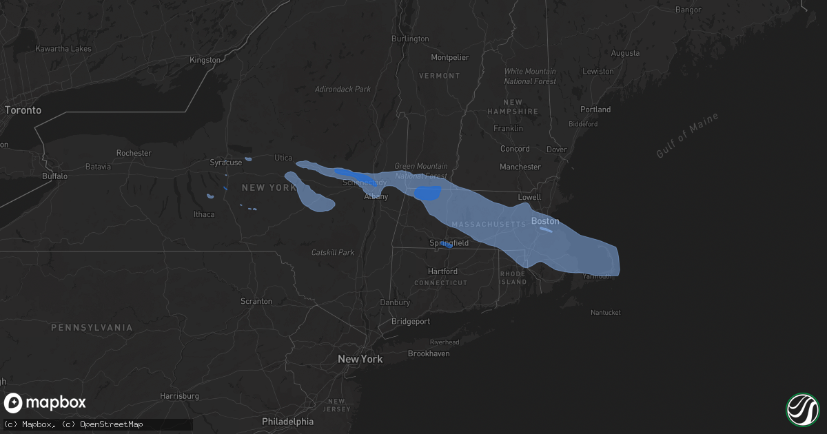
Hail Map on October 7, 2020
Get this storm
October 7 map
$229
one time, instant access
Download today. No call, no setup
Keep the $229
Bought the map and want the full workflow? Apply the entire $229 to a subscription within 7 days. None of it is wasted.
Every map, not just this one
This buys you this map. Subscription and you get every map we run, in the markets you choose from a few cities to whole states to nationwide. Plus real-time alerts the moment a storm fires.
Contact data
Name, contact info, occupancy, even credit band for addresses in the footprint. You go from where it hit to who to call.
Become the source they trust
Unlimited branding weather history reports on demand. You already have the documented answer ready for the property owner, and you are the one who showed up with it.
Property data and RoofTrace estimates
Pull up any address you have got, its value and the exact code rules for that jurisdiction, straight from One Click Code. Then RoofTrace estimates the squares, pitch, and roof value, priced the way you price.
States Impacted by Hail Map on October 7, 2020
Storm reports
New Hampshire
| Date | Description |
|---|---|
| 10/07/20204:50 PM CDT | Trees down. |
| 10/07/20204:41 PM CDT | Tree limbs down and shingles blown off of structure. |
| 10/07/20204:30 PM CDT | Trees and wires down. |
| 10/07/20204:30 PM CDT | Tree across road on stable rd in milford. Time estimated from radar. |
| 10/07/20204:27 PM CDT | Trees and wires down. |
| 10/07/20204:27 PM CDT | Trees and wires down. |
| 10/07/20204:25 PM CDT | Trees and wires down. |
| 10/07/20204:05 PM CDT | Trees and wires down. |
| 10/07/20204:02 PM CDT | Numerous reports of trees and wires down in town. Time estimated from radar. |
| 10/07/20204:02 PM CDT | Numerous reports of trees and wires down in the town of swanzey. Time estimated from radar. |
| 10/07/20204:00 PM CDT | Trees and power lines down. |
| 10/07/20204:00 PM CDT | Trees and power lines down. |
| 10/07/20203:57 PM CDT | Trees and power lines down. |
| 10/07/20203:54 PM CDT | Numerous reports of trees and wires down across town. |
| 10/07/202012:54 AM CDT | At 554 PM EDT, severe thunderstorms were located along a line extending from near Salem to Newton, moving east at 55 mph. HAZARD...70 mph wind gusts. SOURCE...Radar indicated. IMPACT...Expect considerable damage to trees and power lines. Damage is likely to mobile homes and outbuildings. Locations impacted include... Lynn, Peabody, Salem, Beverly, Gloucester, Danvers, Marblehead, Winthrop, Newburyport, Swampscott, Ipswich, Salisbury, Hamilton, Rockport, Newbury, Topsfield, Rowley, Manchester, Wenham and Essex. |
| 10/07/202012:27 AM CDT | At 526 PM EDT, severe thunderstorms were located along a line extending from Brookline to near Sterling to near Spencer, moving east at 70 mph. HAZARD...70 mph wind gusts. SOURCE...Radar indicated. IMPACT...Expect considerable damage to trees and power lines. Damage is likely to mobile homes and outbuildings. Locations impacted include... Boston, Worcester, Lowell, Cambridge, Quincy, Lynn, Newton, Lawrence, Somerville, Framingham, Haverhill, Waltham, Malden, Brookline, Medford, Revere, Peabody, Methuen, Arlington and Everett. |
| 10/06/202011:27 PM CDT | At 426 PM EDT, severe thunderstorms were located along a line extending from near Townshend to Wilmington to near Rowe to Pittsfield to near Chatham to near Coxsackie to 6 miles south of Prattsville, moving southeast at 105 mph. HAZARD...70 mph wind gusts. SOURCE...Radar indicated. IMPACT...Expect considerable tree damage. Damage is likely to mobile homes, roofs, and outbuildings. Locations impacted include... Pittsfield, Torrington, Kingston, North Adams, Brattleboro, Great Barrington, Hudson, Catskill, Saugerties, Rhinebeck, Chatham, Townshend, Hunter, Stratton, Monroe, Adams, New Hartford, Hurley, Claverack and Lee. |
| 10/06/202010:56 PM CDT | At 356 PM EDT, severe thunderstorms were located along a line extending from near Pawlet to Center Brunswick to near Davenport, moving southeast at 80 mph. HAZARD...70 mph wind gusts. SOURCE...Radar indicated. IMPACT...Expect considerable tree damage. Damage is likely to mobile homes, roofs, and outbuildings. Locations impacted include... Albany, Troy, Pittsfield, Bennington, Kingston, East Greenbush, Cohoes, North Adams, Brattleboro, Watervliet, Rensselaer, Colonie, Great Barrington, New Paltz, Hudson, Ellenville, Catskill, Saugerties, Hoosick Falls and Bellows Falls. |
New York
| Date | Description |
|---|---|
| 10/07/20204:05 PM CDT | Wires down on sunset dr. |
| 10/07/20204:04 PM CDT | Trees and powerlines down on martha rd in vestal. |
| 10/07/20204:00 PM CDT | Large tree down near 2400 day hollow road... Blocking half of the roadway. |
| 10/07/20203:54 PM CDT | Tree on wires |
| 10/07/20203:50 PM CDT | Multiple trees down near carmen road in guilderland |
| 10/07/20203:48 PM CDT | Trees on a house and power lines in schenectady |
| 10/07/20203:44 PM CDT | Tree down on county route 9 |
| 10/07/20203:43 PM CDT | Tree on power lines |
| 10/07/20203:42 PM CDT | Pole broken with wires down |
| 10/07/20203:40 PM CDT | Tree on wires |
| 10/07/20203:40 PM CDT | Tree on a house with a partial structural collapse reported in the village of catskill. |
| 10/07/20203:39 PM CDT | Downed wires resulted in road closure on rte 66 at rte 9h. |
| 10/07/20203:39 PM CDT | Tree on wires |
| 10/07/20203:38 PM CDT | Pole snapped and wires down |
| 10/07/20203:37 PM CDT | Tree and wires down |
| 10/07/20203:37 PM CDT | Tree on wires |
| 10/07/20203:36 PM CDT | Pole snapped |
| 10/07/20203:34 PM CDT | Tree and wires down |
| 10/07/20203:30 PM CDT | Tree through house |
| 10/07/20203:28 PM CDT | Tree and wires down |
| 10/07/20203:28 PM CDT | Tree and wires down on vehicle |
| 10/07/20203:27 PM CDT | Tree and wires down |
| 10/07/20203:27 PM CDT | Tree... Wires and pole down |
| 10/07/20203:27 PM CDT | Tree and wires down |
| 10/07/20203:22 PM CDT | Tree and wires down. |
| 10/07/20203:22 PM CDT | Tree and wires down |
| 10/07/20203:22 PM CDT | Trees on powerlines along railroad ave. |
| 10/07/20203:21 PM CDT | Tree on wires |
| 10/07/20203:21 PM CDT | Tree and wires down. |
| 10/07/20203:17 PM CDT | Numerous downed poles/wires along rte 20 between nassau and rte 66. |
| 10/07/20203:16 PM CDT | Route 9j between county route 2 and columbia county line closed due to downed trees and wires |
| 10/07/20203:15 PM CDT | Tree down near intersection of intake rd and ny-23. |
| 10/07/20203:15 PM CDT | Corrects previous tstm wnd dmg report from 6 ne roxbury. Trees down on ferris hill rd. |
| 10/07/20203:13 PM CDT | Large tree down on a car |
| 10/07/20203:10 PM CDT | Numerous large branches with power outages in selkirk. |
| 10/07/20203:10 PM CDT | Several trees down |
| 10/07/20203:10 PM CDT | Tree down blocking route 9w. Time estimated by radar. |
| 10/07/20203:10 PM CDT | Trees and power lines down on wemple road. Time estimated by radar. |
| 10/07/20203:06 PM CDT | Trees down on ferris hill rd. |
| 10/07/20203:06 PM CDT | Tree down on car |
| 10/07/20203:06 PM CDT | Large tree down near crossgates mall |
| 10/07/20203:05 PM CDT | Large tree branches down |
| 10/07/20203:05 PM CDT | Numerous reports of trees down with power outages throughout east greenbush. |
| 10/07/20203:05 PM CDT | Route 144 closed between wemple rd and clapper rd due to downed poles and wires |
| 10/07/20203:04 PM CDT | Trees on round pond rd. |
| 10/07/20203:04 PM CDT | Large tree down on a house |
| 10/07/20203:03 PM CDT | Trees and powerlines down on terry road. |
| 10/07/20203:03 PM CDT | Tree down |
| 10/07/20203:02 PM CDT | Route 22 at hoosick falls high school closed due to downed trees and wires |
| 10/07/20203:01 PM CDT | Downed trees on the ualbany campus |
| 10/07/20203:00 PM CDT | Mutiple trees down near the intersection of new scotland avenue and hartman road |
| 10/07/20203:00 PM CDT | Corrects previous tstm wnd dmg report from stamford. Trees on powerlines along railroad ave. |
| 10/07/20203:00 PM CDT | 40 foot willow tree fell in guilderland. |
| 10/07/20203:00 PM CDT | Route 443 between meads lane and bethlehem town line closed due to downed trees and wires |
| 10/07/20203:00 PM CDT | Large trees uprooted |
| 10/07/20202:59 PM CDT | Trees down. |
| 10/07/20202:58 PM CDT | Tree down on a car. Windshield broken. |
| 10/07/20202:56 PM CDT | Downed tree and large branches snapped |
| 10/07/20202:56 PM CDT | Tree down near croll road and county route 111 |
| 10/07/20202:55 PM CDT | Multiple reports of trees and wires down. |
| 10/07/20202:55 PM CDT | Multiple reports of trees and wires down. |
| 10/07/20202:55 PM CDT | Route 85 between bullock rd and swift rd closed due to downed trees and wires |
| 10/07/20202:54 PM CDT | A microburst along croll road... East of tomhannock reservoir in pittstown...produced significant damage on oct 7... 2020. The microburst moved in a general west southw |
| 10/07/20202:54 PM CDT | Multiple trees down on fences near brick lane in colonie |
| 10/07/20202:53 PM CDT | Trees down near maxwell dr. And ashley dr. Time estimated. |
| 10/07/20202:52 PM CDT | A local report indicates 68 MPH wind near ALBANY INTL AP |
| 10/07/20202:50 PM CDT | Multiple trees down near carmen road in guilderland |
| 10/07/20202:50 PM CDT | Trees and power lines down on charlotte creek rd near pine lake spur rd. |
| 10/07/20202:48 PM CDT | Trees on a house and power lines in schenectady |
| 10/07/20202:48 PM CDT | Trees hanging on power lines and trees down |
| 10/07/20202:48 PM CDT | Trees and powerlines down. |
| 10/07/20202:48 PM CDT | Medium sized branches down along rt 7. |
| 10/07/20202:47 PM CDT | Tree down on rosendale road near mayfield road blocking one lane |
| 10/07/20202:46 PM CDT | Tree down across balltown road near bentley road |
| 10/07/20202:46 PM CDT | Large tree down near lock 7 |
| 10/07/20202:45 PM CDT | Large tree fell near ge plot |
| 10/07/20202:44 PM CDT | Large tree down on barclay place and dean street |
| 10/07/20202:43 PM CDT | Tree and wires down in clifton park center |
| 10/07/20202:43 PM CDT | Trees down on rosendale rd |
| 10/07/20202:42 PM CDT | *** 1 fatal *** pine tree fell on a car and resulted in a fatality |
| 10/07/20202:40 PM CDT | Corrects previous tstm wnd dmg report from 3 w smithville flats. Trees on round pond rd. |
| 10/07/20202:40 PM CDT | Multiple trees down ballston lake |
| 10/07/20202:40 PM CDT | Numerous trees and large branches down. |
| 10/07/20202:38 PM CDT | Tree down blocking intersection of main road and pratt road. |
| 10/07/20202:36 PM CDT | Downed trees and powerlines causing a fire on ny-38. |
| 10/07/20202:35 PM CDT | Trees on multiple houses on imperial la and redwood dr. |
| 10/07/20202:35 PM CDT | Route 337 between route 159 and princetown road closed due to a downed pole and wires. |
| 10/07/20202:35 PM CDT | Trees down on wires along route 7 between route 30 and zicha rd |
| 10/07/20202:35 PM CDT | Numerous trees down in charlton. |
| 10/07/20202:34 PM CDT | Trees down on 434 cr-51. |
| 10/07/20202:34 PM CDT | Large trees down |
| 10/07/20202:30 PM CDT | Tree uprooted near youngs corner rd. And mill pt. Rd. Time estimated. |
| 10/07/20202:30 PM CDT | All lanes blocked on route 30 between hartley and belldons road due to downed trees and wires. |
| 10/07/20202:30 PM CDT | Tree down on vehicle. |
| 10/07/20202:28 PM CDT | Corrects previous tstm wnd dmg report from mc donough. Trees down armstrong rd. |
| 10/07/20202:28 PM CDT | Tree partially fell on a house near the intersection of guy park avenue and northampton road. |
| 10/07/20202:25 PM CDT | Tree on power lines at intersection of charles ln. And sanford ave. Time estimated. |
| 10/07/20202:24 PM CDT | Tree down blocking roadway. |
| 10/07/20202:24 PM CDT | The storm survey team observed several hardwood and softwood trees uprooted in the area. The orientation of the trees was consistent with a straight-line wind microburs |
| 10/07/20202:24 PM CDT | Trees down on reid hill |
| 10/07/20202:21 PM CDT | Trees and power lines down at the intersection of cook rd and williams rd. |
| 10/07/20202:20 PM CDT | Numerous trees down with some snaps in the hamlet of auriesville. |
| 10/07/20202:20 PM CDT | Multiple large branches down near tribes hill and some siding ripped off of a house. |
| 10/07/20202:19 PM CDT | Poles down on ny-23 near the cincinnatus post office. |
| 10/07/20202:18 PM CDT | Trees down armstrong rd. |
| 10/07/20202:18 PM CDT | Tree down blocking roadway. |
| 10/07/20202:17 PM CDT | Barn damaged with debris carried a few hundred yards away |
| 10/07/20202:15 PM CDT | Rte 10 closed between hickory hill rd and dillenbeck rd due to downed power pole and wires. |
| 10/07/20202:15 PM CDT | Tree down |
| 10/07/20202:14 PM CDT | The storm survey team observed a nearly destroyed barn with metal siding strewn about the property. A tree was also toppled. This was the only damage. The tornado was v |
| 10/07/20202:10 PM CDT | Trees down on angel hill road. |
| 10/07/20202:09 PM CDT | Trees down on tunnicliff rd near schuyler lake. |
| 10/07/20202:05 PM CDT | Multiple trees down along route 5 in northerm montgomery county. |
| 10/07/20202:04 PM CDT | Trees down on carson road. |
| 10/07/20202:02 PM CDT | Tree down on vehicle on thompson hill road. |
| 10/07/20202:01 PM CDT | Tree down blocking road on main street near rt 90. |
| 10/07/20202:00 PM CDT | Report from mping: 3-inch tree limbs broken; power poles broken. |
| 10/07/20202:00 PM CDT | Corrects previous tstm wnd dmg report from 2 ne south brookfield. Trees across road. |
| 10/07/20201:59 PM CDT | Tree on a house in cedarville |
| 10/07/20201:59 PM CDT | Numerous trees and powerlines down between 6961 and 7400 block of ny-51. Ny-51 closed near ny-23. |
| 10/07/20201:59 PM CDT | Multiple trees down in little falls |
| 10/07/20201:55 PM CDT | Us-11 closed due to several downed trees and poles. |
| 10/07/20201:55 PM CDT | Tree and wires down |
| 10/07/20201:54 PM CDT | Trees and powerlines down near otisco valley road and masters road. |
| 10/07/20201:44 PM CDT | Tree on a trailer |
| 10/07/20201:44 PM CDT | Down utlity poles and wires blocking route 30 |
| 10/07/20201:40 PM CDT | Corrects previous tstm wnd dmg report from 2 w new york mills. Report from mping: 3-inch tree limbs broken; power poles broken. |
| 10/07/20201:39 PM CDT | Large tree branch down on notre dame lane. |
| 10/07/20201:36 PM CDT | 3 inch tree limbs broken... Wires down. |
| 10/07/20201:31 PM CDT | Trees across road. |
| 10/07/20201:30 PM CDT | Tree snapped in half... Wires down. |
| 10/07/20201:30 PM CDT | Tree down over road. |
| 10/07/20201:29 PM CDT | Wires down. |
| 10/07/20201:20 PM CDT | Tree and wire down. |
| 10/07/20201:20 PM CDT | Corrects previous tstm wnd dmg report from marcellus. Large tree came down on car and clipped a house. Video posted on social media and time estimated from radar. |
| 10/07/20201:15 PM CDT | 10 foot tall tree with 8 inch diameter snapped at the base. Pea size hail. |
| 10/07/20201:15 PM CDT | Blanchard/clark sts - lines down. |
| 10/07/20201:10 PM CDT | Large tree came down on car and clipped a house. Video posted on social media and time estimated from radar. |
| 10/07/202012:39 PM CDT | Tree down. |
| 10/07/202012:18 PM CDT | A local report indicates 58 MPH wind near 2 W OSWEGO |
| 10/07/202012:06 PM CDT | Trees down. |
| 10/07/202012:30 AM CDT | At 529 PM EDT, severe thunderstorms were located along a line extending from near Wolcott to Lake Carmel, moving east at 45 mph. HAZARD...60 mph wind gusts. SOURCE...Radar indicated. IMPACT...Expect damage to trees and power lines. Severe thunderstorms will be near... Waterbury and Wolcott around 535 PM EDT. Cheshire around 540 PM EDT. Meriden and Brookfield around 545 PM EDT. Danbury and Middletown around 550 PM EDT. Newtown and Hartford around 555 PM EDT. Durham and Redding around 600 PM EDT. Monroe around 605 PM EDT. Bridgeport and Trumbull around 610 PM EDT. New Haven and Milford around 615 PM EDT. |
| 10/07/202012:14 AM CDT | At 514 PM EDT, severe thunderstorms were located along a line extending from near Binghamton to near Sanford, moving southeast at 40 mph. HAZARD...60 mph wind gusts. SOURCE...Radar indicated. IMPACT...Expect damage to roofs, siding, and trees. Locations impacted include... Binghamton, Kirkwood, Conklin, Jackson, Sanford, Susquehanna, Deposit, Susquehanna Depot, Hallstead and Hancock. |
| 10/06/202011:43 PM CDT | At 443 PM EDT, a severe thunderstorm was located over Candor, or 10 miles northwest of Owego, moving southeast at 50 mph. HAZARD...60 mph wind gusts. SOURCE...Radar indicated. IMPACT...Expect damage to roofs, siding, and trees. Locations impacted include... Binghamton, Vestal, Endicott, Owego, Newark Valley, Candor, Spencer, Nichols, Apalachin and Tioga Terrace. |
| 10/06/202011:01 PM CDT | At 400 PM EDT, a severe thunderstorm was located over Slaterville Springs, or 8 miles east of Ithaca, moving southeast at 35 mph. HAZARD...60 mph wind gusts. SOURCE...Radar indicated. IMPACT...Expect damage to roofs, siding, and trees. Locations impacted include... Maine, Caroline, Nanticoke, Berkshire, Richford, Newark Valley, Whitney Point, Lisle, Brooktondale and Slaterville Springs. |
| 10/06/202010:40 PM CDT | At 340 PM EDT, severe thunderstorms were located along a line extending from Richmondville to near Milford, moving southeast at 50 mph. HAZARD...60 mph wind gusts. SOURCE...Radar indicated. IMPACT...Expect damage to roofs, siding, and trees. Locations impacted include... Jefferson, Windham, Gilboa, Prattsville, Livingstonville, North Blenheim, Breakabeen, Preston-Potter Hollow, Preston Hollow, Cairo, Durham, Ashland, Jewett, Lexington, Conesville, West Settlement, Baird Corners, North Lexington, Maplecrest and Result. |
| 10/06/202010:28 PM CDT | At 327 PM EDT, severe thunderstorms were located along a line extending from near Ames to Willet, moving southeast at 45 mph. HAZARD...60 mph wind gusts. SOURCE...Radar indicated. IMPACT...Expect damage to roofs, siding, and trees. Locations impacted include... Oneonta, Norwich, Sidney, Delhi, Davenport, Guilford, Worcester, Middlefield, Hartwick and Maryland. |
| 10/06/20209:46 PM CDT | At 245 PM EDT, severe thunderstorms were located along a line extending from 13 miles southwest of Lake Pleasant to near Stratford to near Clayville, moving east at 65 mph. HAZARD...60 mph wind gusts. SOURCE...Radar indicated. IMPACT...Expect damage to roofs, siding, and trees. Locations impacted include... Amsterdam, Gloversville, Johnstown, Ilion, Herkimer, Little Falls, Canajoharie, Fonda, Glenville, Mohawk, Frankfort, Corinth, Fort Plain, Dolgeville, St. Johnsville, Ephratah, Broadalbin, Hagaman, Edinburg and Northville. |
| 10/06/20209:44 PM CDT | At 243 PM EDT, severe thunderstorms were located along a line extending from near Frankfort to near Erieville, moving southeast at 55 mph. HAZARD...60 mph wind gusts and penny size hail. SOURCE...Radar indicated. IMPACT...Expect damage to roofs, siding, and trees. Locations impacted include... Utica, Norwich, Eaton, Paris, Deerfield, Hamilton, New York Mills, Yorkville, Brookfield and Morrisville. |
| 10/06/20209:13 PM CDT | At 213 PM EDT, a severe thunderstorm was located over Auburn, moving southeast at 50 mph. HAZARD...60 mph wind gusts and quarter size hail. SOURCE...Radar indicated. IMPACT...Hail damage to vehicles is expected. Expect wind damage to roofs, siding, and trees. Locations impacted include... Onondaga, Syracuse, Auburn, De Witt, Cortland, Van Buren, Baldwinsville, Pompey, Solvay and Manlius. |
| 10/06/20209:01 PM CDT | At 200 PM EDT, a severe thunderstorm was located near Bridgeport, or 11 miles northwest of Oneida, moving southeast at 60 mph. HAZARD...60 mph wind gusts and quarter size hail. SOURCE...Radar indicated. IMPACT...Hail damage to vehicles is expected. Expect wind damage to roofs, siding, and trees. Locations impacted include... Syracuse, Utica, Clay, Rome, Cicero, De Witt, Sullivan, Oneida, Kirkland and Lenox. |
| 10/06/20208:36 PM CDT | At 135 PM EDT, a severe thunderstorm was located over Battle Island State Park, or near Fulton, moving southeast at 40 mph. HAZARD...60 mph wind gusts and quarter size hail. SOURCE...Radar indicated. IMPACT...Minor damage to vehicles is possible. Expect wind damage to roofs, siding, and trees. Locations impacted include... Fulton, Central Square, Mexico Point State Park, Battle Island State Park, Hastings, Volney, Constantia, West Monroe, Palermo and New Haven. This includes Interstate 81 between exits 32 and 34. |
| 10/06/20208:02 PM CDT | At 101 PM EDT, a severe thunderstorm was located over Adams, or 13 miles southwest of Watertown, moving east at 30 mph. HAZARD...60 mph wind gusts and quarter size hail. SOURCE...Radar indicated. IMPACT...Minor damage to vehicles is possible. Expect wind damage to roofs, siding, and trees. Locations impacted include... Adams, Henderson Harbor, Barnes Corners, Southwick Beach State Park, Adams Center, Denmark, Henderson, Smithville, Rodman and Lorraine. This includes Interstate 81 between exits 40 and 43. |
Rhode Island
| Date | Description |
|---|---|
| 10/07/20205:24 PM CDT | A local report indicates 61 MPH wind near 1 SE PROVIDENCE |
| 10/07/20205:14 PM CDT | Tree uprooted in the manville section of lincoln |
| 10/07/20205:07 PM CDT | A local report indicates 61 MPH wind near CUMBERLAND |
| 10/07/20205:04 PM CDT | Tree down on two cars... No injuries. Cars heavily damaged. |
Connecticut
| Date | Description |
|---|---|
| 10/07/20205:05 PM CDT | A wind gust of 63 mph was measured at chapel street historic district station. |
| 10/07/20205:05 PM CDT | Numerous reports of trees... Branches... And power lines down. |
| 10/07/20204:50 PM CDT | A couple of trees and powerlines down in town. Time estimated by radar. |
| 10/07/20204:50 PM CDT | Tree/wires down - blocking rt 169 |
| 10/07/20204:43 PM CDT | Multiple reports of large branches and wires down across town. |
| 10/07/20204:43 PM CDT | Multiple reports of trees and wires down across town. |
| 10/07/20204:39 PM CDT | A local report indicates 64 MPH wind near BRADLEY AP |
| 10/07/20204:39 PM CDT | Telephone poles reported down with wires down on eagle road. |
| 10/07/20204:38 PM CDT | Telephone wires down with damage to telephone pole at crestwood drive and great plain road with time estimated by radar. |
| 10/07/20204:30 PM CDT | Multiple trees down in multiple locations in town |
| 10/07/20204:30 PM CDT | Multiple trees down in multiple locations in town |
| 10/07/20204:29 PM CDT | Downed trees |
| 10/07/20204:28 PM CDT | Tree down |
| 10/07/20204:24 PM CDT | Downed trees |
| 10/07/20201:03 AM CDT | At 602 PM EDT, severe thunderstorms were located along a line extending from Canton to near Killingly, moving southeast at 55 mph. HAZARD...60 mph wind gusts. SOURCE...Radar indicated. IMPACT...Expect damage to trees and power lines. Locations impacted include... Providence, New Bedford, Brockton, Quincy, Fall River, Warwick, Cranston, Pawtucket, Plymouth, Taunton, Weymouth, East Providence, Woonsocket, Braintree, Coventry, Dartmouth, Cumberland, Randolph, North Providence and Franklin. |
| 10/07/202012:47 AM CDT | At 546 PM EDT, severe thunderstorms were located along a line extending from near Woodstock to near Simsbury, moving east at 50 mph. HAZARD...70 mph wind gusts. SOURCE...Radar indicated. IMPACT...Expect considerable damage to trees and power lines. Damage is likely to mobile homes and outbuildings. Locations impacted include... Hartford, New Britain, West Hartford, Bristol, Manchester, East Hartford, Woonsocket, Glastonbury, Cumberland, Newington, Vernon, Windsor, Johnston, Wethersfield, Mansfield, South Windsor, Farmington, Windham, Plainfield and Simsbury. |
| 10/07/202012:38 AM CDT | At 537 PM EDT, severe thunderstorms were located along a line extending from Westborough to near Enfield, moving east at 65 mph. HAZARD...70 mph wind gusts. SOURCE...Radar indicated. IMPACT...Expect considerable damage to trees and power lines. Damage is likely to mobile homes and outbuildings. Locations impacted include... Brockton, Quincy, Weymouth, Enfield, Woonsocket, Braintree, Cumberland, Randolph, Franklin, North Attleborough, Norwood, Milford, Milton, Stoughton, Dedham, Walpole, Mansfield, Easton, Hingham and Canton. |
| 10/07/202012:25 AM CDT | At 525 PM EDT, severe thunderstorms were located along a line extending from Terryville to near Woodbury Center to near New Milford, moving southeast at 25 mph. HAZARD...60 mph wind gusts. SOURCE...Radar indicated. IMPACT...Expect damage to roofs, siding, and trees. Locations impacted include... New Milford, Thomaston, Terryville, Woodbury Center, Oakville, Watertown, Plymouth, Woodbury, Bethlehem, Washington, Roxbury, Bridgewater, Candlewood Springs, Hotchkissville, Pequabuck, Reynolds Bridge, Hancock, River Road Reserve, Candlewood Trails and Pomeraug. |
| 10/07/202012:22 AM CDT | At 522 PM EDT, severe thunderstorms were located along a line extending from Paxton to near Granby, moving east at 85 mph. HAZARD...60 mph wind gusts. SOURCE...Radar indicated. IMPACT...Expect damage to trees and power lines. Locations impacted include... Worcester, Springfield, Enfield, Shrewsbury, Agawam, West Springfield, Ludlow, Westborough, Grafton, Webster, Southbridge, Auburn, Longmeadow, Suffield, East Longmeadow, Ellington, Tolland, Wilbraham, Northborough and Oxford. |
| 10/06/202011:47 PM CDT | At 447 PM EDT, a severe thunderstorm was located over Pleasant Valley, or near Poughkeepsie, moving southeast at 35 mph. HAZARD...60 mph wind gusts and penny size hail. SOURCE...Radar indicated. IMPACT...Expect damage to roofs, siding, and trees. Locations impacted include... Poughkeepsie, Pawling, Pleasant Valley, Wappingers Falls, Highland, Millbrook, Fairview, Hopewell Junction, Red Oaks Mill, Myers Corner, Wingdale, Dover Plains, East Fishkill, Beekman, Stormville, Salt Point, Baker Corner, Knapps Corner, South Dover and Hoxie Corner. |
Vermont
| Date | Description |
|---|---|
| 10/07/20203:56 PM CDT | Tree down on lavigne rd |
| 10/07/20203:15 PM CDT | Widepsread downed trees and power lines |
| 10/07/20203:10 PM CDT | Trees down |
| 10/07/20203:10 PM CDT | Trees and wires down on route 7 between jackson cross road and center sreet |
| 10/06/202011:50 PM CDT | At 450 PM EDT, severe thunderstorms were located along a line extending from near Northfield to near Sunderland to near Williamsburg, moving east at 50 mph. HAZARD...60 mph wind gusts. SOURCE...Radar indicated. IMPACT...Expect damage to trees and power lines. Locations impacted include... Worcester, Leominster, Fitchburg, Amherst, Shrewsbury, Northampton, Orange, Deerfield, Gardner, South Hadley, Holden, Belchertown, Northborough, Clinton, Palmer, Spencer, Athol, Pepperell, Leicester and Groton. |
Maine
| Date | Description |
|---|---|
| 10/07/202012:11 AM CDT | At 510 PM EDT, a severe thunderstorm was located near Alton, or 14 miles northwest of Rochester, moving east at 45 mph. HAZARD...60 mph wind gusts. SOURCE...Radar indicated. IMPACT...Expect damage to roofs, siding, and trees. Locations impacted include... Rochester, Alfred, Sanford, Berwick, Farmington, Lebanon, Alton, Wolfeboro, Acton, Brookfield, New Durham, Middleton, Milton, Shapleigh, Wakefield and North Berwick. |
Massachusetts
| Date | Description |
|---|---|
| 10/07/20206:41 PM CDT | A local report indicates 60 MPH wind near NANTUCKET AP |
| 10/07/20206:13 PM CDT | A local report indicates 64 MPH wind near DENNIS |
| 10/07/20205:52 PM CDT | West island |
| 10/07/20205:45 PM CDT | A local report indicates 63 MPH wind near 9 WNW TRURO |
| 10/07/20205:35 PM CDT | A local report indicates 82 MPH wind near QUINCY |
| 10/07/20205:33 PM CDT | A local report indicates 60 MPH wind near PLYMOUTH AP |
| 10/07/20205:32 PM CDT | Redwood dr - tree down on wires - wires smoking |
| 10/07/20205:31 PM CDT | Multiple trees down on south street between foxborough high school and taylor school south. Street closed |
| 10/07/20205:19 PM CDT | Prospect st - large 10 inch diameter branch blocking traffic. Top half of tree down on marion st |
| 10/07/20205:17 PM CDT | Tree down at cambridge terrace |
| 10/07/20205:12 PM CDT | Trees down in the feedinghills section |
| 10/07/20205:12 PM CDT | A local report indicates 65 MPH wind near HINGHAM |
| 10/07/20205:05 PM CDT | Multiple trees down... Snapped... Or uprooted from mill brook drive to pine brook drive. Four trees were downed on houses. |
| 10/07/20205:05 PM CDT | Resident from braintree reported a 64 mph wind gust with their anemometer at about 0605 pm on 10/7. Damage in the immediate area was mostly downed tree limbs. |
| 10/07/20205:02 PM CDT | A local report indicates 68 MPH wind near BLUE HILL ASOS |
| 10/07/20205:01 PM CDT | A local report indicates 58 MPH wind near NORWOOD AP |
| 10/07/20205:01 PM CDT | A local report indicates 58 MPH wind near WRENTHAM |
| 10/07/20205:00 PM CDT | Tree uprooted and tree split in half on wright rd in west concord. Telephone pole down at lawsbrook rd |
| 10/07/20205:00 PM CDT | A local report indicates 66 MPH wind near LOGAN AP |
| 10/07/20205:00 PM CDT | Multiple trees down on laurel dr |
| 10/07/20204:55 PM CDT | Multiple trees down around south street |
| 10/07/20204:55 PM CDT | Tree down on mountain view road |
| 10/07/20204:53 PM CDT | A local report indicates 58 MPH wind near MENDON |
| 10/07/20204:50 PM CDT | Tree down blocking school st |
| 10/07/20204:50 PM CDT | Nws survey found ef-0 tornado in millis... Ma on ground for less than 1 minute... With path length of 1/2 mile... Width 50 yards... And maximum speed of 75-80 mph. Bega |
| 10/07/20204:46 PM CDT | Small tree down on brockelman rd |
| 10/07/20204:45 PM CDT | Tree and wires down on ash st. Large branch one foot in diameter down on milk st with wires down. |
| 10/07/20204:45 PM CDT | Tree down on house; on anthony st... On third st... And tree blocking loveland st |
| 10/07/20204:45 PM CDT | Multiple trees down at 196 worcester road |
| 10/07/20204:45 PM CDT | North grafton... Tree down at frances/jay st. |
| 10/07/20204:45 PM CDT | Teacher from norfolk county agricultural high school in walpole reported that nearly 100 tree went down with the storm last night around 5:45 pm. |
| 10/07/20204:45 PM CDT | Multiple trees and wires down across town |
| 10/07/20204:40 PM CDT | Trees down on colonial st - road blocked |
| 10/07/20204:40 PM CDT | Trees snapped on green st |
| 10/07/20204:40 PM CDT | Multiple trees/wires down with road closures on tuttle... Kilburn... & north row road |
| 10/07/20204:37 PM CDT | A local report indicates 60 MPH wind near HUDSON |
| 10/07/20204:35 PM CDT | Tree on garage/truck at westernview circle. |
| 10/07/20204:30 PM CDT | Multiple reports of trees down; ed holcomb rd... Hillside rd ranch golf club... Jerry drive... Miller rd... Hillside rd wires down... Southwick acres campground |
| 10/07/20204:30 PM CDT | Tree limbs down across the city; beechmont st [limb on house]... Brantwood rd... Pleasant st [limb on house]... Dayton st... Main st... Varnum st... June st... Maxwell |
| 10/07/20204:27 PM CDT | *** 5 inj *** devens fire chief reported 5 injuries from ft. Devens when a military-grade tent was blown over by thunderstorm winds. The 5 injured were taken to the hos |
| 10/07/20204:27 PM CDT | A local report indicates 70 MPH wind near WORCESTER AP |
| 10/07/20204:26 PM CDT | Reports of numerous trees down across agawam |
| 10/07/20204:24 PM CDT | A local report indicates 60 MPH wind near FITCHBURG AP |
| 10/07/20204:24 PM CDT | Liberty st - tree down |
| 10/07/20204:21 PM CDT | River run road - tree down across road with wires down |
| 10/07/20204:20 PM CDT | Downed trees and wires |
| 10/07/20204:16 PM CDT | Downed tree |
| 10/07/20204:15 PM CDT | Numerous trees down on route 141 |
| 10/07/20204:15 PM CDT | Tree and wires down on birchland ave. Tree split and landed on house on jeffery road. |
| 10/07/20204:13 PM CDT | A local report indicates 74 MPH wind near WESTFIELD-BARNES AP |
| 10/07/20204:11 PM CDT | A local report indicates 63 MPH wind near WESTOVER AFB |
| 10/07/20204:10 PM CDT | Northampton road just east of dana - tree down blocking road |
| 10/07/20204:09 PM CDT | Pleasant street - tree and wires down |
| 10/07/20204:05 PM CDT | Powerline down on car on lyman st |
| 10/07/20204:03 PM CDT | Route 112 - tree down |
| 10/07/20204:03 PM CDT | Tree down on car at 47 florence road |
| 10/07/20204:02 PM CDT | Observation from a mesonet site. |
| 10/07/20204:00 PM CDT | Large tree blocking route 10 about 1/2 mile north of union st |
| 10/07/20204:00 PM CDT | Tree down on three cars on pine street |
| 10/07/20203:58 PM CDT | Multiple trees down on i-91 in whately and deerfield - roadway is blocked |
| 10/07/20203:55 PM CDT | *** 1 fatal *** trees down on man in golf cart on wyantenuck golf course. Time estimated. |
| 10/07/20203:54 PM CDT | 392 chesterfield road - tree down blocking road in the leeds section of northampton |
| 10/07/20203:53 PM CDT | Interstate 91 southbound - tree down on car - no injuries |
| 10/07/20203:52 PM CDT | Summit street at west street - tree and wires down |
| 10/07/20203:49 PM CDT | Hawley road - trees down |
| 10/07/20203:48 PM CDT | Baptist hill road - tree down |
| 10/07/20203:48 PM CDT | Parts of route 20 closed in lee due to downed trees |
| 10/07/20203:48 PM CDT | Interstate 91 southbound exit 28 off ramp - tree blocking ramp |
| 10/07/20203:48 PM CDT | Multiple downed trees |
| 10/07/20203:47 PM CDT | Tree down on route 116 |
| 10/07/20203:45 PM CDT | Multiple trees... Utility poles... And wires down on adamsville road and foundry |
| 10/07/20203:42 PM CDT | 24 old main road - tree and wires down |
| 10/07/20203:34 PM CDT | Large tree limb down |
| 10/07/20203:33 PM CDT | A local report indicates 60 MPH wind near PITTSFIELD MUNICIPAL AP |
| 10/07/20203:33 PM CDT | Tree and wires down on route 9 at the intersection of hill street and hill road |
| 10/07/20203:31 PM CDT | Multiple trees down |
| 10/07/20203:29 PM CDT | Multiple 3-4 inch branches down with power outages - also multiple small trees down on ford hill road. |
| 10/07/20203:25 PM CDT | Multiple trees down |
| 10/07/20203:25 PM CDT | Tree down in lanesboro near route 8 |
| 10/07/20203:21 PM CDT | Multiple trees down |
| 10/07/20203:17 PM CDT | A local report indicates 60 MPH wind near HARRIMAN-AND-WEST-AI |
| 10/07/20203:16 PM CDT | Tree down on car |
| 10/07/20201:36 AM CDT | At 635 PM EDT, severe thunderstorms were located along a line extending from 18 miles north of Provincetown to near Plymouth to near Somerset, moving east at 60 mph. HAZARD...60 mph wind gusts. SOURCE...Radar indicated. IMPACT...Expect damage to trees and power lines. Locations impacted include... New Bedford, Fall River, Plymouth, Barnstable, Dartmouth, Falmouth, Brewster, Marion, Provincetown, Yarmouth, Middleborough, Wareham, Sandwich, Bourne, Somerset, Portsmouth, Barrington, Middletown, Fairhaven and Swansea. |
| 10/07/202012:30 AM CDT | At 529 PM EDT, severe thunderstorms were located along a line extending from near Hooksett to Brookline, moving east at 65 mph. HAZARD...60 mph wind gusts. SOURCE...Radar indicated. IMPACT...Expect damage to roofs, siding, and trees. Locations impacted include... Manchester, Nashua, Derry, Hampton, Exeter, Merrimack, Salem, Bedford, Milford, Hooksett, Amherst, Litchfield, Hollis, Epping, Brentwood, Greenland, Mason, Raymond, Seabrook and Hudson.This includes the following highways... Interstate 293 between mile markers 1 and 10. Interstate 93 between mile markers 0 and 24. Interstate 95 in New Hampshire between mile markers 0 and 9.This also includes... Hampton Beach. |
| 10/06/202011:59 PM CDT | At 458 PM EDT, severe thunderstorms were located along a line extending from near Nelson to near Troy, moving east at 60 mph. HAZARD...60 mph wind gusts. SOURCE...Radar indicated. IMPACT...Expect damage to roofs, siding, and trees. Locations impacted include... Nashua, Merrimack, Jaffrey, Bedford, Milford, Amherst, Hollis, Swanzey, Peterborough, New Boston, Antrim, Mont Vernon, Greenfield, Lyndeborough, Dublin, Francestown, Bennington, Richmond, Harrisville and Nelson.This also includes... Mount Monadnock and North Pack Monadnock. |
| 10/06/202011:57 PM CDT | At 457 PM EDT, severe thunderstorms were located along a line extending from near Chester to near Great Barrington to near Sheffield to near Livingston, moving southeast at 55 mph. HAZARD...70 mph wind gusts. SOURCE...Radar indicated. IMPACT...Expect considerable tree damage. Damage is likely to mobile homes, roofs, and outbuildings. Locations impacted include... Torrington, Great Barrington, New Hartford, Copake, Sheffield, Clermont, Norfolk, Otis, Ancram, Canaan, Millerton, Sandisfield, New Hartford Center, Ashley Falls, Falls Village, Winsted, Barkhamsted, Salisbury, New Marlborough and Colebrook. |
| 10/06/202011:39 PM CDT | At 438 PM EDT, severe thunderstorms were located along a line extending from 6 miles northwest of Hinsdale to 13 miles southwest of Winchester, moving east at 70 mph. HAZARD...60 mph wind gusts. SOURCE...Radar indicated. IMPACT...Expect damage to roofs, siding, and trees. Locations impacted include... Jaffrey, Swanzey, Winchester, Richmond, Rindge, Hinsdale, Fitzwilliam, Troy and Chesterfield. |
| 10/06/202011:38 PM CDT | At 438 PM EDT, severe thunderstorms were located along a line extending from near East Windsor to near Austerlitz, moving east at 65 mph. HAZARD...60 mph wind gusts. SOURCE...Radar indicated. IMPACT...Expect damage to trees and power lines. Locations impacted include... Springfield, Chicopee, Westfield, Holyoke, Amherst, Northampton, Agawam, West Springfield, Ludlow, South Hadley, Easthampton, Longmeadow, East Longmeadow, Belchertown, Wilbraham, Palmer, Ware, Southwick, Monson and Granby. |
| 10/06/202011:13 PM CDT | At 412 PM EDT, severe thunderstorms were located along a line extending from near Shaftsbury to near Williamstown to near Nassau, moving east at 55 mph. HAZARD...70 mph wind gusts. SOURCE...Radar indicated. IMPACT...Expect considerable damage to trees and power lines. Damage is likely to mobile homes and outbuildings. Locations impacted include... Amherst, Northampton, Greenfield, Orange, Deerfield, Monroe, Montague, Hadley, Sunderland, Hatfield, Northfield, Williamsburg, Bernardston, Buckland, Conway, Shelburne, Leverett, Erving, Shutesbury and Ashfield. |
Cities Impacted by Hail Map on October 7, 2020
- Syracuse, NY
- La Fayette, NY
- Homer, NY
- Preble, NY
- Locke, NY
- Canastota, NY
- Westford, NY
- East Worcester, NY
- Stamford, NY
- Richfield Springs, NY
- Maryland, NY
- Summit, NY
- Richmondville, NY
- Worcester, NY
- Schenevus, NY
- Davenport, NY
- Warnerville, NY
- Roseboom, NY
- West Fulton, NY
- Cooperstown, NY
- Middleburgh, NY
- Burlington Flats, NY
- West Winfield, NY
- Fly Creek, NY
- Charlotteville, NY
- Milford, NY
- Cherry Valley, NY
- Ilion, NY
- Fultonham, NY
- Jefferson, NY
- Hartwick, NY
- Glendale, RI
- Pembroke, MA
- North Bennington, VT
- Bedford, MA
- East Wareham, MA
- Watertown, MA
- Clifton Park, NY
- Providence, RI
- Douglas, MA
- Dudley, MA
- Wellesley, MA
- Ballston Lake, NY
- Turners Falls, MA
- Hudson, MA
- North Easton, MA
- New Salem, MA
- Barre, MA
- Chelmsford, MA
- Wrentham, MA
- Avon, MA
- Bolton, MA
- Wendell Depot, MA
- Rowe, MA
- Orange, MA
- Holliston, MA
- East Boston, MA
- Charlemont, MA
- South Dennis, MA
- North Adams, MA
- Shelburne Falls, MA
- Harvard, MA
- Newtonville, MA
- Mattapan, MA
- Rehoboth, MA
- Sharon, MA
- Leicester, MA
- Cohasset, MA
- Waban, MA
- Charlestown, MA
- Petersburg, NY
- Slatersville, RI
- Onset, MA
- Goshen, MA
- Bridgewater, MA
- Marlborough, MA
- Cherry Valley, MA
- Sagamore Beach, MA
- East Sandwich, MA
- Fayville, MA
- Westwood, MA
- North Weymouth, MA
- Melrose, NY
- Palmer, MA
- Haydenville, MA
- West Barnstable, MA
- Medway, MA
- Cumberland, RI
- Clinton, MA
- North Chatham, MA
- North Providence, RI
- Waltham, MA
- Newton, MA
- Stillwater, NY
- Conway, MA
- Paxton, MA
- Delanson, NY
- Northfield, MA
- Hubbardston, MA
- Webster, MA
- Norwood, MA
- Mapleville, RI
- Malden, MA
- Watervliet, NY
- Valley Falls, NY
- Rexford, NY
- Hanover, MA
- Bondsville, MA
- Milton, MA
- Bernardston, MA
- Baldwinville, MA
- Canton, MA
- Manville, RI
- Wynantskill, NY
- Norfolk, MA
- Wellesley Hills, MA
- Southbridge, MA
- Savoy, MA
- Seekonk, MA
- Stoughton, MA
- Boylston, MA
- Duxbury, MA
- Esperance, NY
- Bennington, VT
- Natick, MA
- Dennis, MA
- Fiskdale, MA
- Jamaica Plain, MA
- Hinsdale, NH
- Middleboro, MA
- Hatfield, MA
- Duanesburg, NY
- Newton Highlands, MA
- North Oxford, MA
- East Brookfield, MA
- Schaghticoke, NY
- Provincetown, MA
- Westborough, MA
- Albany, NY
- Alplaus, NY
- Worcester, MA
- Needham, MA
- Roslindale, MA
- Cambridge, MA
- Hoosick Falls, NY
- Herkimer, NY
- Sherborn, MA
- Millbury, MA
- Whitinsville, MA
- Pattersonville, NY
- Woburn, MA
- Greenfield, MA
- Cohoes, NY
- Wayland, MA
- Scituate, MA
- Wellfleet, MA
- Cropseyville, NY
- Winchester, NH
- Belchertown, MA
- Latham, NY
- Bellingham, MA
- Saint Johnsville, NY
- Maynard, MA
- Brewster, MA
- Holbrook, MA
- Roxbury Crossing, MA
- Oakham, MA
- Berkley, MA
- Hardwick, MA
- Grafton, MA
- Taunton, MA
- Rensselaer, NY
- Jefferson, MA
- Braintree, MA
- East Taunton, MA
- Dedham, MA
- Princeton, MA
- Johnstown, NY
- Northampton, MA
- Guilderland, NY
- West Roxbury, MA
- Newton Upper Falls, MA
- Johnston, RI
- Athol, MA
- Holden, MA
- South Hadley, MA
- Riverside, RI
- Stamford, VT
- West Boylston, MA
- Palatine Bridge, NY
- Billerica, MA
- Sagamore, MA
- Boston, MA
- Chepachet, RI
- Sterling, MA
- Lancaster, MA
- Humarock, MA
- Quincy, MA
- Whitman, MA
- Northborough, MA
- Medfield, MA
- Slingerlands, NY
- Petersham, MA
- Gilbertville, MA
- Fultonville, NY
- Warwick, MA
- Uxbridge, MA
- Rochdale, MA
- North Dighton, MA
- Kingston, MA
- Granby, MA
- Fort Plain, NY
- Hopkinton, MA
- Rotterdam Junction, NY
- Hingham, MA
- Norwell, MA
- South Easton, MA
- Orleans, MA
- Central Falls, RI
- Brookline, MA
- Cummington, MA
- Mechanicville, NY
- Carlisle, MA
- Shrewsbury, MA
- Plainville, MA
- Eagle Bridge, NY
- New Braintree, MA
- Fort Hunter, NY
- Mansfield, MA
- Hopedale, MA
- Harrisville, RI
- Milford, MA
- Newton Lower Falls, MA
- Mohawk, NY
- Norton, MA
- Nelliston, NY
- Vernon, VT
- South Boston, MA
- Waterford, NY
- Hadley, MA
- Montague, MA
- Royalston, MA
- Forestdale, RI
- Dorchester Center, MA
- Canajoharie, NY
- Southborough, MA
- East Bridgewater, MA
- Tribes Hill, NY
- Newton Center, MA
- Auburndale, MA
- West Newton, MA
- Smithfield, RI
- Millville, MA
- Gardner, MA
- Allston, MA
- Medford, MA
- Troy, NY
- Sandwich, MA
- Lexington, MA
- Foxboro, MA
- Wareham, MA
- North Brookfield, MA
- Attleboro, MA
- Williamstown, MA
- Deerfield, MA
- Chelsea, MA
- Blackstone, MA
- Brockton, MA
- Acton, MA
- Ware, MA
- Buskirk, NY
- Adams, MA
- Chestnut Hill, MA
- Rockland, MA
- Monroe Bridge, MA
- Dorchester, MA
- Roxbury, MA
- Boxborough, MA
- Wendell, MA
- Leeds, MA
- Winthrop, MA
- Whitingham, VT
- Schenectady, NY
- Fitchburg, MA
- Marshfield, MA
- Woonsocket, RI
- Abington, MA
- North Hatfield, MA
- South Barre, MA
- Belmont, MA
- Franklin, MA
- Round Lake, NY
- Berlin, NY
- Wilmington, VT
- West Bridgewater, MA
- Raynham, MA
- Leominster, MA
- Buckland, MA
- Everett, MA
- Jacksonville, VT
- Templeton, MA
- Florence, MA
- Lincoln, RI
- South Grafton, MA
- Lunenburg, MA
- Hanson, MA
- Upton, MA
- Carver, MA
- Leverett, MA
- Gill, MA
- Ashland, MA
- North Grafton, MA
- Sudbury, MA
- South Deerfield, MA
- Pawtucket, RI
- Amherst, MA
- Millers Falls, MA
- Hull, MA
- Arlington, MA
- Westminster, MA
- Albion, RI
- Harwich, MA
- Burlington, MA
- Lincoln, MA
- Stow, MA
- Brookfield, MA
- North Pownal, VT
- Rumford, RI
- Altamont, NY
- Spencer, MA
- Weymouth, MA
- Chatham, MA
- Marion, MA
- Hanscom Afb, MA
- North Truro, MA
- Revere, MA
- Colrain, MA
- Sprakers, NY
- Walpole, MA
- Eastham, MA
- East Walpole, MA
- West Halifax, VT
- South Walpole, MA
- Fort Johnson, NY
- Delmar, NY
- Attleboro Falls, MA
- Plymouth, MA
- Concord, MA
- Winchendon, MA
- Auburn, MA
- East Weymouth, MA
- Warren, MA
- Westford, MA
- Ashfield, MA
- Oxford, MA
- North Attleboro, MA
- West Warren, MA
- Sutton, MA
- Oakland, RI
- Mendon, MA
- Williamsburg, MA
- Sunderland, MA
- Shutesbury, MA
- Halifax, MA
- Plainfield, MA
- Brimfield, MA
- Berlin, MA
- South Weymouth, MA
- North Billerica, MA
- North Smithfield, RI
- Lakeville, MA
- Needham Heights, MA
- Pascoag, RI
- Rochester, MA
- Truro, MA
- Chesterfield, MA
- Burnt Hills, NY
- Dover, MA
- Pownal, VT
- Readsboro, VT
- Brighton, MA
- Little Falls, NY
- Framingham, MA
- Northbridge, MA
- Drury, MA
- Amsterdam, NY
- Lake Pleasant, MA
- Hyde Park, MA
- East Providence, RI
- Winchester, MA
- West Wareham, MA
- Brattleboro, VT
- West Brookfield, MA
- Somerville, MA
- Buzzards Bay, MA
- Weston, MA
- Erving, MA
- Johnsonville, NY
- Heath, MA
- West Hatfield, MA
- Rutland, MA
- Millis, MA
- Randolph, MA
- Littleton, MA
- Yarmouth Port, MA
- Fonda, NY
- Charlton, MA
- Sturbridge, MA
- Plympton, MA
- Cincinnatus, NY
- McDonough, NY
- Oxford, NY
- East Longmeadow, MA
- West Springfield, MA
- Westfield, MA
- Feeding Hills, MA
- Longmeadow, MA
- Springfield, MA
- Agawam, MA