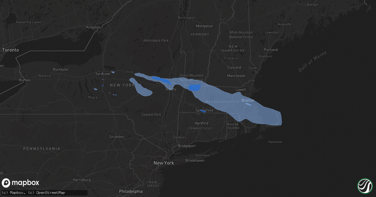
Hail Map in New Hampshire on October 7, 2020
Get this storm
October 7 map
$229
one time, instant access
Download today. No call, no setup
Keep the $229
Bought the map and want the full workflow? Apply the entire $229 to a subscription within 7 days. None of it is wasted.
Every map, not just this one
This buys you this map. Subscription and you get every map we run, in the markets you choose from a few cities to whole states to nationwide. Plus real-time alerts the moment a storm fires.
Contact data
Name, contact info, occupancy, even credit band for addresses in the footprint. You go from where it hit to who to call.
Become the source they trust
Unlimited branding weather history reports on demand. You already have the documented answer ready for the property owner, and you are the one who showed up with it.
Property data and RoofTrace estimates
Pull up any address you have got, its value and the exact code rules for that jurisdiction, straight from One Click Code. Then RoofTrace estimates the squares, pitch, and roof value, priced the way you price.
Storm reports in New Hampshire
New Hampshire
| Date | Description |
|---|---|
| 10/07/20204:50 PM CDT | Trees down. |
| 10/07/20204:41 PM CDT | Tree limbs down and shingles blown off of structure. |
| 10/07/20204:30 PM CDT | Trees and wires down. |
| 10/07/20204:30 PM CDT | Tree across road on stable rd in milford. Time estimated from radar. |
| 10/07/20204:27 PM CDT | Trees and wires down. |
| 10/07/20204:27 PM CDT | Trees and wires down. |
| 10/07/20204:25 PM CDT | Trees and wires down. |
| 10/07/20204:05 PM CDT | Trees and wires down. |
| 10/07/20204:02 PM CDT | Numerous reports of trees and wires down in town. Time estimated from radar. |
| 10/07/20204:02 PM CDT | Numerous reports of trees and wires down in the town of swanzey. Time estimated from radar. |
| 10/07/20204:00 PM CDT | Trees and power lines down. |
| 10/07/20204:00 PM CDT | Trees and power lines down. |
| 10/07/20203:57 PM CDT | Trees and power lines down. |
| 10/07/20203:54 PM CDT | Numerous reports of trees and wires down across town. |
| 10/07/202012:54 AM CDT | At 554 PM EDT, severe thunderstorms were located along a line extending from near Salem to Newton, moving east at 55 mph. HAZARD...70 mph wind gusts. SOURCE...Radar indicated. IMPACT...Expect considerable damage to trees and power lines. Damage is likely to mobile homes and outbuildings. Locations impacted include... Lynn, Peabody, Salem, Beverly, Gloucester, Danvers, Marblehead, Winthrop, Newburyport, Swampscott, Ipswich, Salisbury, Hamilton, Rockport, Newbury, Topsfield, Rowley, Manchester, Wenham and Essex. |
| 10/07/202012:27 AM CDT | At 526 PM EDT, severe thunderstorms were located along a line extending from Brookline to near Sterling to near Spencer, moving east at 70 mph. HAZARD...70 mph wind gusts. SOURCE...Radar indicated. IMPACT...Expect considerable damage to trees and power lines. Damage is likely to mobile homes and outbuildings. Locations impacted include... Boston, Worcester, Lowell, Cambridge, Quincy, Lynn, Newton, Lawrence, Somerville, Framingham, Haverhill, Waltham, Malden, Brookline, Medford, Revere, Peabody, Methuen, Arlington and Everett. |
| 10/06/202011:27 PM CDT | At 426 PM EDT, severe thunderstorms were located along a line extending from near Townshend to Wilmington to near Rowe to Pittsfield to near Chatham to near Coxsackie to 6 miles south of Prattsville, moving southeast at 105 mph. HAZARD...70 mph wind gusts. SOURCE...Radar indicated. IMPACT...Expect considerable tree damage. Damage is likely to mobile homes, roofs, and outbuildings. Locations impacted include... Pittsfield, Torrington, Kingston, North Adams, Brattleboro, Great Barrington, Hudson, Catskill, Saugerties, Rhinebeck, Chatham, Townshend, Hunter, Stratton, Monroe, Adams, New Hartford, Hurley, Claverack and Lee. |
| 10/06/202010:56 PM CDT | At 356 PM EDT, severe thunderstorms were located along a line extending from near Pawlet to Center Brunswick to near Davenport, moving southeast at 80 mph. HAZARD...70 mph wind gusts. SOURCE...Radar indicated. IMPACT...Expect considerable tree damage. Damage is likely to mobile homes, roofs, and outbuildings. Locations impacted include... Albany, Troy, Pittsfield, Bennington, Kingston, East Greenbush, Cohoes, North Adams, Brattleboro, Watervliet, Rensselaer, Colonie, Great Barrington, New Paltz, Hudson, Ellenville, Catskill, Saugerties, Hoosick Falls and Bellows Falls. |
All States Impacted by Hail Map on October 7, 2020
Cities Impacted by Hail Map on October 7, 2020
- Syracuse, NY
- La Fayette, NY
- Homer, NY
- Preble, NY
- Locke, NY
- Canastota, NY
- Westford, NY
- East Worcester, NY
- Stamford, NY
- Richfield Springs, NY
- Maryland, NY
- Summit, NY
- Richmondville, NY
- Worcester, NY
- Schenevus, NY
- Davenport, NY
- Warnerville, NY
- Roseboom, NY
- West Fulton, NY
- Cooperstown, NY
- Middleburgh, NY
- Burlington Flats, NY
- West Winfield, NY
- Fly Creek, NY
- Charlotteville, NY
- Milford, NY
- Cherry Valley, NY
- Ilion, NY
- Fultonham, NY
- Jefferson, NY
- Hartwick, NY
- Glendale, RI
- Pembroke, MA
- North Bennington, VT
- Bedford, MA
- East Wareham, MA
- Watertown, MA
- Clifton Park, NY
- Providence, RI
- Douglas, MA
- Dudley, MA
- Wellesley, MA
- Ballston Lake, NY
- Turners Falls, MA
- Hudson, MA
- North Easton, MA
- New Salem, MA
- Barre, MA
- Chelmsford, MA
- Wrentham, MA
- Avon, MA
- Bolton, MA
- Wendell Depot, MA
- Rowe, MA
- Orange, MA
- Holliston, MA
- East Boston, MA
- Charlemont, MA
- South Dennis, MA
- North Adams, MA
- Shelburne Falls, MA
- Harvard, MA
- Newtonville, MA
- Mattapan, MA
- Rehoboth, MA
- Sharon, MA
- Leicester, MA
- Cohasset, MA
- Waban, MA
- Charlestown, MA
- Petersburg, NY
- Slatersville, RI
- Onset, MA
- Goshen, MA
- Bridgewater, MA
- Marlborough, MA
- Cherry Valley, MA
- Sagamore Beach, MA
- East Sandwich, MA
- Fayville, MA
- Westwood, MA
- North Weymouth, MA
- Melrose, NY
- Palmer, MA
- Haydenville, MA
- West Barnstable, MA
- Medway, MA
- Cumberland, RI
- Clinton, MA
- North Chatham, MA
- North Providence, RI
- Waltham, MA
- Newton, MA
- Stillwater, NY
- Conway, MA
- Paxton, MA
- Delanson, NY
- Northfield, MA
- Hubbardston, MA
- Webster, MA
- Norwood, MA
- Mapleville, RI
- Malden, MA
- Watervliet, NY
- Valley Falls, NY
- Rexford, NY
- Hanover, MA
- Bondsville, MA
- Milton, MA
- Bernardston, MA
- Baldwinville, MA
- Canton, MA
- Manville, RI
- Wynantskill, NY
- Norfolk, MA
- Wellesley Hills, MA
- Southbridge, MA
- Savoy, MA
- Seekonk, MA
- Stoughton, MA
- Boylston, MA
- Duxbury, MA
- Esperance, NY
- Bennington, VT
- Natick, MA
- Dennis, MA
- Fiskdale, MA
- Jamaica Plain, MA
- Hinsdale, NH
- Middleboro, MA
- Hatfield, MA
- Duanesburg, NY
- Newton Highlands, MA
- North Oxford, MA
- East Brookfield, MA
- Schaghticoke, NY
- Provincetown, MA
- Westborough, MA
- Albany, NY
- Alplaus, NY
- Worcester, MA
- Needham, MA
- Roslindale, MA
- Cambridge, MA
- Hoosick Falls, NY
- Herkimer, NY
- Sherborn, MA
- Millbury, MA
- Whitinsville, MA
- Pattersonville, NY
- Woburn, MA
- Greenfield, MA
- Cohoes, NY
- Wayland, MA
- Scituate, MA
- Wellfleet, MA
- Cropseyville, NY
- Winchester, NH
- Belchertown, MA
- Latham, NY
- Bellingham, MA
- Saint Johnsville, NY
- Maynard, MA
- Brewster, MA
- Holbrook, MA
- Roxbury Crossing, MA
- Oakham, MA
- Berkley, MA
- Hardwick, MA
- Grafton, MA
- Taunton, MA
- Rensselaer, NY
- Jefferson, MA
- Braintree, MA
- East Taunton, MA
- Dedham, MA
- Princeton, MA
- Johnstown, NY
- Northampton, MA
- Guilderland, NY
- West Roxbury, MA
- Newton Upper Falls, MA
- Johnston, RI
- Athol, MA
- Holden, MA
- South Hadley, MA
- Riverside, RI
- Stamford, VT
- West Boylston, MA
- Palatine Bridge, NY
- Billerica, MA
- Sagamore, MA
- Boston, MA
- Chepachet, RI
- Sterling, MA
- Lancaster, MA
- Humarock, MA
- Quincy, MA
- Whitman, MA
- Northborough, MA
- Medfield, MA
- Slingerlands, NY
- Petersham, MA
- Gilbertville, MA
- Fultonville, NY
- Warwick, MA
- Uxbridge, MA
- Rochdale, MA
- North Dighton, MA
- Kingston, MA
- Granby, MA
- Fort Plain, NY
- Hopkinton, MA
- Rotterdam Junction, NY
- Hingham, MA
- Norwell, MA
- South Easton, MA
- Orleans, MA
- Central Falls, RI
- Brookline, MA
- Cummington, MA
- Mechanicville, NY
- Carlisle, MA
- Shrewsbury, MA
- Plainville, MA
- Eagle Bridge, NY
- New Braintree, MA
- Fort Hunter, NY
- Mansfield, MA
- Hopedale, MA
- Harrisville, RI
- Milford, MA
- Newton Lower Falls, MA
- Mohawk, NY
- Norton, MA
- Nelliston, NY
- Vernon, VT
- South Boston, MA
- Waterford, NY
- Hadley, MA
- Montague, MA
- Royalston, MA
- Forestdale, RI
- Dorchester Center, MA
- Canajoharie, NY
- Southborough, MA
- East Bridgewater, MA
- Tribes Hill, NY
- Newton Center, MA
- Auburndale, MA
- West Newton, MA
- Smithfield, RI
- Millville, MA
- Gardner, MA
- Allston, MA
- Medford, MA
- Troy, NY
- Sandwich, MA
- Lexington, MA
- Foxboro, MA
- Wareham, MA
- North Brookfield, MA
- Attleboro, MA
- Williamstown, MA
- Deerfield, MA
- Chelsea, MA
- Blackstone, MA
- Brockton, MA
- Acton, MA
- Ware, MA
- Buskirk, NY
- Adams, MA
- Chestnut Hill, MA
- Rockland, MA
- Monroe Bridge, MA
- Dorchester, MA
- Roxbury, MA
- Boxborough, MA
- Wendell, MA
- Leeds, MA
- Winthrop, MA
- Whitingham, VT
- Schenectady, NY
- Fitchburg, MA
- Marshfield, MA
- Woonsocket, RI
- Abington, MA
- North Hatfield, MA
- South Barre, MA
- Belmont, MA
- Franklin, MA
- Round Lake, NY
- Berlin, NY
- Wilmington, VT
- West Bridgewater, MA
- Raynham, MA
- Leominster, MA
- Buckland, MA
- Everett, MA
- Jacksonville, VT
- Templeton, MA
- Florence, MA
- Lincoln, RI
- South Grafton, MA
- Lunenburg, MA
- Hanson, MA
- Upton, MA
- Carver, MA
- Leverett, MA
- Gill, MA
- Ashland, MA
- North Grafton, MA
- Sudbury, MA
- South Deerfield, MA
- Pawtucket, RI
- Amherst, MA
- Millers Falls, MA
- Hull, MA
- Arlington, MA
- Westminster, MA
- Albion, RI
- Harwich, MA
- Burlington, MA
- Lincoln, MA
- Stow, MA
- Brookfield, MA
- North Pownal, VT
- Rumford, RI
- Altamont, NY
- Spencer, MA
- Weymouth, MA
- Chatham, MA
- Marion, MA
- Hanscom Afb, MA
- North Truro, MA
- Revere, MA
- Colrain, MA
- Sprakers, NY
- Walpole, MA
- Eastham, MA
- East Walpole, MA
- West Halifax, VT
- South Walpole, MA
- Fort Johnson, NY
- Delmar, NY
- Attleboro Falls, MA
- Plymouth, MA
- Concord, MA
- Winchendon, MA
- Auburn, MA
- East Weymouth, MA
- Warren, MA
- Westford, MA
- Ashfield, MA
- Oxford, MA
- North Attleboro, MA
- West Warren, MA
- Sutton, MA
- Oakland, RI
- Mendon, MA
- Williamsburg, MA
- Sunderland, MA
- Shutesbury, MA
- Halifax, MA
- Plainfield, MA
- Brimfield, MA
- Berlin, MA
- South Weymouth, MA
- North Billerica, MA
- North Smithfield, RI
- Lakeville, MA
- Needham Heights, MA
- Pascoag, RI
- Rochester, MA
- Truro, MA
- Chesterfield, MA
- Burnt Hills, NY
- Dover, MA
- Pownal, VT
- Readsboro, VT
- Brighton, MA
- Little Falls, NY
- Framingham, MA
- Northbridge, MA
- Drury, MA
- Amsterdam, NY
- Lake Pleasant, MA
- Hyde Park, MA
- East Providence, RI
- Winchester, MA
- West Wareham, MA
- Brattleboro, VT
- West Brookfield, MA
- Somerville, MA
- Buzzards Bay, MA
- Weston, MA
- Erving, MA
- Johnsonville, NY
- Heath, MA
- West Hatfield, MA
- Rutland, MA
- Millis, MA
- Randolph, MA
- Littleton, MA
- Yarmouth Port, MA
- Fonda, NY
- Charlton, MA
- Sturbridge, MA
- Plympton, MA
- Cincinnatus, NY
- McDonough, NY
- Oxford, NY
- East Longmeadow, MA
- West Springfield, MA
- Westfield, MA
- Feeding Hills, MA
- Longmeadow, MA
- Springfield, MA
- Agawam, MA


