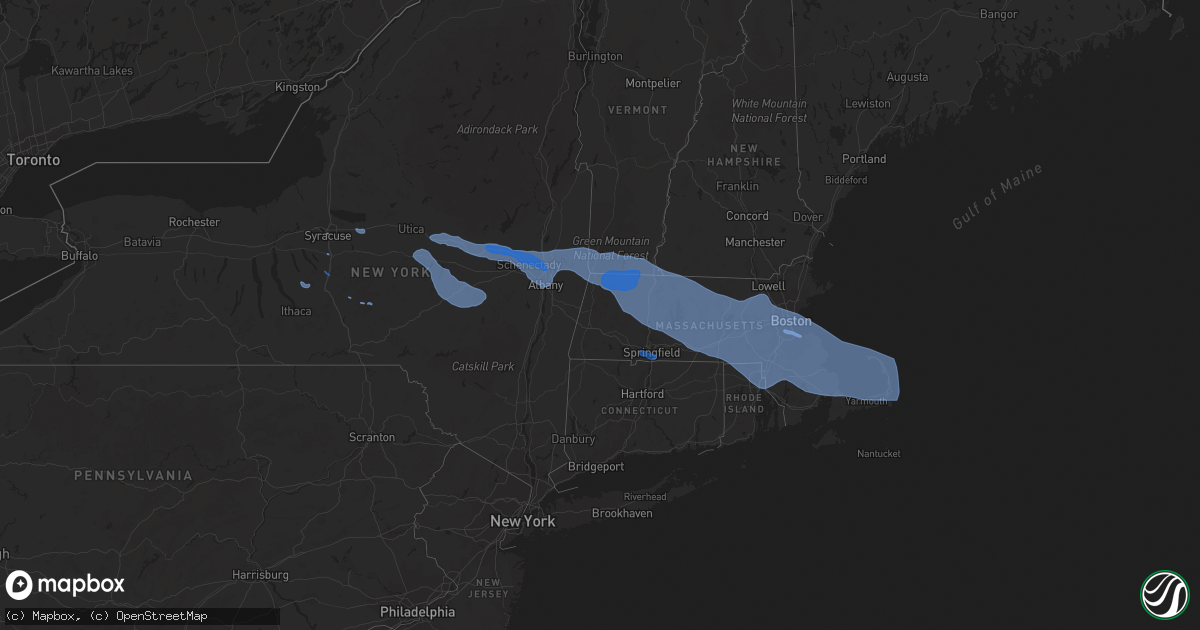
Hail Map in New York on October 7, 2020
Get this storm
October 7 map
$229
one time, instant access
Download today. No call, no setup
Keep the $229
Bought the map and want the full workflow? Apply the entire $229 to a subscription within 7 days. None of it is wasted.
Every map, not just this one
This buys you this map. Subscription and you get every map we run, in the markets you choose from a few cities to whole states to nationwide. Plus real-time alerts the moment a storm fires.
Contact data
Name, contact info, occupancy, even credit band for addresses in the footprint. You go from where it hit to who to call.
Become the source they trust
Unlimited branding weather history reports on demand. You already have the documented answer ready for the property owner, and you are the one who showed up with it.
Property data and RoofTrace estimates
Pull up any address you have got, its value and the exact code rules for that jurisdiction, straight from One Click Code. Then RoofTrace estimates the squares, pitch, and roof value, priced the way you price.
Storm reports in New York
New York
| Date | Description |
|---|---|
| 10/07/20204:05 PM CDT | Wires down on sunset dr. |
| 10/07/20204:04 PM CDT | Trees and powerlines down on martha rd in vestal. |
| 10/07/20204:00 PM CDT | Large tree down near 2400 day hollow road... Blocking half of the roadway. |
| 10/07/20203:54 PM CDT | Tree on wires |
| 10/07/20203:50 PM CDT | Multiple trees down near carmen road in guilderland |
| 10/07/20203:48 PM CDT | Trees on a house and power lines in schenectady |
| 10/07/20203:44 PM CDT | Tree down on county route 9 |
| 10/07/20203:43 PM CDT | Tree on power lines |
| 10/07/20203:42 PM CDT | Pole broken with wires down |
| 10/07/20203:40 PM CDT | Tree on wires |
| 10/07/20203:40 PM CDT | Tree on a house with a partial structural collapse reported in the village of catskill. |
| 10/07/20203:39 PM CDT | Downed wires resulted in road closure on rte 66 at rte 9h. |
| 10/07/20203:39 PM CDT | Tree on wires |
| 10/07/20203:38 PM CDT | Pole snapped and wires down |
| 10/07/20203:37 PM CDT | Tree on wires |
| 10/07/20203:37 PM CDT | Tree and wires down |
| 10/07/20203:36 PM CDT | Pole snapped |
| 10/07/20203:34 PM CDT | Tree and wires down |
| 10/07/20203:30 PM CDT | Tree through house |
| 10/07/20203:28 PM CDT | Tree and wires down |
| 10/07/20203:28 PM CDT | Tree and wires down on vehicle |
| 10/07/20203:27 PM CDT | Tree and wires down |
| 10/07/20203:27 PM CDT | Tree... Wires and pole down |
| 10/07/20203:27 PM CDT | Tree and wires down |
| 10/07/20203:22 PM CDT | Tree and wires down. |
| 10/07/20203:22 PM CDT | Trees on powerlines along railroad ave. |
| 10/07/20203:22 PM CDT | Tree and wires down |
| 10/07/20203:21 PM CDT | Tree and wires down. |
| 10/07/20203:21 PM CDT | Tree on wires |
| 10/07/20203:17 PM CDT | Numerous downed poles/wires along rte 20 between nassau and rte 66. |
| 10/07/20203:16 PM CDT | Route 9j between county route 2 and columbia county line closed due to downed trees and wires |
| 10/07/20203:15 PM CDT | Corrects previous tstm wnd dmg report from 6 ne roxbury. Trees down on ferris hill rd. |
| 10/07/20203:15 PM CDT | Tree down near intersection of intake rd and ny-23. |
| 10/07/20203:13 PM CDT | Large tree down on a car |
| 10/07/20203:10 PM CDT | Trees and power lines down on wemple road. Time estimated by radar. |
| 10/07/20203:10 PM CDT | Numerous large branches with power outages in selkirk. |
| 10/07/20203:10 PM CDT | Several trees down |
| 10/07/20203:10 PM CDT | Tree down blocking route 9w. Time estimated by radar. |
| 10/07/20203:06 PM CDT | Large tree down near crossgates mall |
| 10/07/20203:06 PM CDT | Tree down on car |
| 10/07/20203:06 PM CDT | Trees down on ferris hill rd. |
| 10/07/20203:05 PM CDT | Numerous reports of trees down with power outages throughout east greenbush. |
| 10/07/20203:05 PM CDT | Route 144 closed between wemple rd and clapper rd due to downed poles and wires |
| 10/07/20203:05 PM CDT | Large tree branches down |
| 10/07/20203:04 PM CDT | Trees on round pond rd. |
| 10/07/20203:04 PM CDT | Large tree down on a house |
| 10/07/20203:03 PM CDT | Trees and powerlines down on terry road. |
| 10/07/20203:03 PM CDT | Tree down |
| 10/07/20203:02 PM CDT | Route 22 at hoosick falls high school closed due to downed trees and wires |
| 10/07/20203:01 PM CDT | Downed trees on the ualbany campus |
| 10/07/20203:00 PM CDT | 40 foot willow tree fell in guilderland. |
| 10/07/20203:00 PM CDT | Corrects previous tstm wnd dmg report from stamford. Trees on powerlines along railroad ave. |
| 10/07/20203:00 PM CDT | Large trees uprooted |
| 10/07/20203:00 PM CDT | Route 443 between meads lane and bethlehem town line closed due to downed trees and wires |
| 10/07/20203:00 PM CDT | Mutiple trees down near the intersection of new scotland avenue and hartman road |
| 10/07/20202:59 PM CDT | Trees down. |
| 10/07/20202:58 PM CDT | Tree down on a car. Windshield broken. |
| 10/07/20202:56 PM CDT | Downed tree and large branches snapped |
| 10/07/20202:56 PM CDT | Tree down near croll road and county route 111 |
| 10/07/20202:55 PM CDT | Multiple reports of trees and wires down. |
| 10/07/20202:55 PM CDT | Route 85 between bullock rd and swift rd closed due to downed trees and wires |
| 10/07/20202:55 PM CDT | Multiple reports of trees and wires down. |
| 10/07/20202:54 PM CDT | A microburst along croll road... East of tomhannock reservoir in pittstown...produced significant damage on oct 7... 2020. The microburst moved in a general west southw |
| 10/07/20202:54 PM CDT | Multiple trees down on fences near brick lane in colonie |
| 10/07/20202:53 PM CDT | Trees down near maxwell dr. And ashley dr. Time estimated. |
| 10/07/20202:52 PM CDT | A local report indicates 68 MPH wind near ALBANY INTL AP |
| 10/07/20202:50 PM CDT | Trees and power lines down on charlotte creek rd near pine lake spur rd. |
| 10/07/20202:50 PM CDT | Multiple trees down near carmen road in guilderland |
| 10/07/20202:48 PM CDT | Medium sized branches down along rt 7. |
| 10/07/20202:48 PM CDT | Trees on a house and power lines in schenectady |
| 10/07/20202:48 PM CDT | Trees hanging on power lines and trees down |
| 10/07/20202:48 PM CDT | Trees and powerlines down. |
| 10/07/20202:47 PM CDT | Tree down on rosendale road near mayfield road blocking one lane |
| 10/07/20202:46 PM CDT | Tree down across balltown road near bentley road |
| 10/07/20202:46 PM CDT | Large tree down near lock 7 |
| 10/07/20202:45 PM CDT | Large tree fell near ge plot |
| 10/07/20202:44 PM CDT | Large tree down on barclay place and dean street |
| 10/07/20202:43 PM CDT | Trees down on rosendale rd |
| 10/07/20202:43 PM CDT | Tree and wires down in clifton park center |
| 10/07/20202:42 PM CDT | *** 1 fatal *** pine tree fell on a car and resulted in a fatality |
| 10/07/20202:40 PM CDT | Multiple trees down ballston lake |
| 10/07/20202:40 PM CDT | Corrects previous tstm wnd dmg report from 3 w smithville flats. Trees on round pond rd. |
| 10/07/20202:40 PM CDT | Numerous trees and large branches down. |
| 10/07/20202:38 PM CDT | Tree down blocking intersection of main road and pratt road. |
| 10/07/20202:36 PM CDT | Downed trees and powerlines causing a fire on ny-38. |
| 10/07/20202:35 PM CDT | Numerous trees down in charlton. |
| 10/07/20202:35 PM CDT | Trees down on wires along route 7 between route 30 and zicha rd |
| 10/07/20202:35 PM CDT | Route 337 between route 159 and princetown road closed due to a downed pole and wires. |
| 10/07/20202:35 PM CDT | Trees on multiple houses on imperial la and redwood dr. |
| 10/07/20202:34 PM CDT | Trees down on 434 cr-51. |
| 10/07/20202:34 PM CDT | Large trees down |
| 10/07/20202:30 PM CDT | All lanes blocked on route 30 between hartley and belldons road due to downed trees and wires. |
| 10/07/20202:30 PM CDT | Tree uprooted near youngs corner rd. And mill pt. Rd. Time estimated. |
| 10/07/20202:30 PM CDT | Tree down on vehicle. |
| 10/07/20202:28 PM CDT | Tree partially fell on a house near the intersection of guy park avenue and northampton road. |
| 10/07/20202:28 PM CDT | Corrects previous tstm wnd dmg report from mc donough. Trees down armstrong rd. |
| 10/07/20202:25 PM CDT | Tree on power lines at intersection of charles ln. And sanford ave. Time estimated. |
| 10/07/20202:24 PM CDT | Tree down blocking roadway. |
| 10/07/20202:24 PM CDT | Trees down on reid hill |
| 10/07/20202:24 PM CDT | The storm survey team observed several hardwood and softwood trees uprooted in the area. The orientation of the trees was consistent with a straight-line wind microburs |
| 10/07/20202:21 PM CDT | Trees and power lines down at the intersection of cook rd and williams rd. |
| 10/07/20202:20 PM CDT | Numerous trees down with some snaps in the hamlet of auriesville. |
| 10/07/20202:20 PM CDT | Multiple large branches down near tribes hill and some siding ripped off of a house. |
| 10/07/20202:19 PM CDT | Poles down on ny-23 near the cincinnatus post office. |
| 10/07/20202:18 PM CDT | Tree down blocking roadway. |
| 10/07/20202:18 PM CDT | Trees down armstrong rd. |
| 10/07/20202:17 PM CDT | Barn damaged with debris carried a few hundred yards away |
| 10/07/20202:15 PM CDT | Rte 10 closed between hickory hill rd and dillenbeck rd due to downed power pole and wires. |
| 10/07/20202:15 PM CDT | Tree down |
| 10/07/20202:14 PM CDT | The storm survey team observed a nearly destroyed barn with metal siding strewn about the property. A tree was also toppled. This was the only damage. The tornado was v |
| 10/07/20202:10 PM CDT | Trees down on angel hill road. |
| 10/07/20202:09 PM CDT | Trees down on tunnicliff rd near schuyler lake. |
| 10/07/20202:05 PM CDT | Multiple trees down along route 5 in northerm montgomery county. |
| 10/07/20202:04 PM CDT | Trees down on carson road. |
| 10/07/20202:02 PM CDT | Tree down on vehicle on thompson hill road. |
| 10/07/20202:01 PM CDT | Tree down blocking road on main street near rt 90. |
| 10/07/20202:00 PM CDT | Corrects previous tstm wnd dmg report from 2 ne south brookfield. Trees across road. |
| 10/07/20202:00 PM CDT | Report from mping: 3-inch tree limbs broken; power poles broken. |
| 10/07/20201:59 PM CDT | Multiple trees down in little falls |
| 10/07/20201:59 PM CDT | Tree on a house in cedarville |
| 10/07/20201:59 PM CDT | Numerous trees and powerlines down between 6961 and 7400 block of ny-51. Ny-51 closed near ny-23. |
| 10/07/20201:55 PM CDT | Us-11 closed due to several downed trees and poles. |
| 10/07/20201:55 PM CDT | Tree and wires down |
| 10/07/20201:54 PM CDT | Trees and powerlines down near otisco valley road and masters road. |
| 10/07/20201:44 PM CDT | Tree on a trailer |
| 10/07/20201:44 PM CDT | Down utlity poles and wires blocking route 30 |
| 10/07/20201:40 PM CDT | Corrects previous tstm wnd dmg report from 2 w new york mills. Report from mping: 3-inch tree limbs broken; power poles broken. |
| 10/07/20201:39 PM CDT | Large tree branch down on notre dame lane. |
| 10/07/20201:36 PM CDT | 3 inch tree limbs broken... Wires down. |
| 10/07/20201:31 PM CDT | Trees across road. |
| 10/07/20201:30 PM CDT | Tree down over road. |
| 10/07/20201:30 PM CDT | Tree snapped in half... Wires down. |
| 10/07/20201:29 PM CDT | Wires down. |
| 10/07/20201:20 PM CDT | Tree and wire down. |
| 10/07/20201:20 PM CDT | Corrects previous tstm wnd dmg report from marcellus. Large tree came down on car and clipped a house. Video posted on social media and time estimated from radar. |
| 10/07/20201:15 PM CDT | Blanchard/clark sts - lines down. |
| 10/07/20201:15 PM CDT | 10 foot tall tree with 8 inch diameter snapped at the base. Pea size hail. |
| 10/07/20201:10 PM CDT | Large tree came down on car and clipped a house. Video posted on social media and time estimated from radar. |
| 10/07/202012:39 PM CDT | Tree down. |
| 10/07/202012:18 PM CDT | A local report indicates 58 MPH wind near 2 W OSWEGO |
| 10/07/202012:06 PM CDT | Trees down. |
| 10/07/202012:30 AM CDT | At 529 PM EDT, severe thunderstorms were located along a line extending from near Wolcott to Lake Carmel, moving east at 45 mph. HAZARD...60 mph wind gusts. SOURCE...Radar indicated. IMPACT...Expect damage to trees and power lines. Severe thunderstorms will be near... Waterbury and Wolcott around 535 PM EDT. Cheshire around 540 PM EDT. Meriden and Brookfield around 545 PM EDT. Danbury and Middletown around 550 PM EDT. Newtown and Hartford around 555 PM EDT. Durham and Redding around 600 PM EDT. Monroe around 605 PM EDT. Bridgeport and Trumbull around 610 PM EDT. New Haven and Milford around 615 PM EDT. |
| 10/07/202012:14 AM CDT | At 514 PM EDT, severe thunderstorms were located along a line extending from near Binghamton to near Sanford, moving southeast at 40 mph. HAZARD...60 mph wind gusts. SOURCE...Radar indicated. IMPACT...Expect damage to roofs, siding, and trees. Locations impacted include... Binghamton, Kirkwood, Conklin, Jackson, Sanford, Susquehanna, Deposit, Susquehanna Depot, Hallstead and Hancock. |
| 10/06/202011:43 PM CDT | At 443 PM EDT, a severe thunderstorm was located over Candor, or 10 miles northwest of Owego, moving southeast at 50 mph. HAZARD...60 mph wind gusts. SOURCE...Radar indicated. IMPACT...Expect damage to roofs, siding, and trees. Locations impacted include... Binghamton, Vestal, Endicott, Owego, Newark Valley, Candor, Spencer, Nichols, Apalachin and Tioga Terrace. |
| 10/06/202011:01 PM CDT | At 400 PM EDT, a severe thunderstorm was located over Slaterville Springs, or 8 miles east of Ithaca, moving southeast at 35 mph. HAZARD...60 mph wind gusts. SOURCE...Radar indicated. IMPACT...Expect damage to roofs, siding, and trees. Locations impacted include... Maine, Caroline, Nanticoke, Berkshire, Richford, Newark Valley, Whitney Point, Lisle, Brooktondale and Slaterville Springs. |
| 10/06/202010:40 PM CDT | At 340 PM EDT, severe thunderstorms were located along a line extending from Richmondville to near Milford, moving southeast at 50 mph. HAZARD...60 mph wind gusts. SOURCE...Radar indicated. IMPACT...Expect damage to roofs, siding, and trees. Locations impacted include... Jefferson, Windham, Gilboa, Prattsville, Livingstonville, North Blenheim, Breakabeen, Preston-Potter Hollow, Preston Hollow, Cairo, Durham, Ashland, Jewett, Lexington, Conesville, West Settlement, Baird Corners, North Lexington, Maplecrest and Result. |
| 10/06/202010:28 PM CDT | At 327 PM EDT, severe thunderstorms were located along a line extending from near Ames to Willet, moving southeast at 45 mph. HAZARD...60 mph wind gusts. SOURCE...Radar indicated. IMPACT...Expect damage to roofs, siding, and trees. Locations impacted include... Oneonta, Norwich, Sidney, Delhi, Davenport, Guilford, Worcester, Middlefield, Hartwick and Maryland. |
| 10/06/20209:46 PM CDT | At 245 PM EDT, severe thunderstorms were located along a line extending from 13 miles southwest of Lake Pleasant to near Stratford to near Clayville, moving east at 65 mph. HAZARD...60 mph wind gusts. SOURCE...Radar indicated. IMPACT...Expect damage to roofs, siding, and trees. Locations impacted include... Amsterdam, Gloversville, Johnstown, Ilion, Herkimer, Little Falls, Canajoharie, Fonda, Glenville, Mohawk, Frankfort, Corinth, Fort Plain, Dolgeville, St. Johnsville, Ephratah, Broadalbin, Hagaman, Edinburg and Northville. |
| 10/06/20209:44 PM CDT | At 243 PM EDT, severe thunderstorms were located along a line extending from near Frankfort to near Erieville, moving southeast at 55 mph. HAZARD...60 mph wind gusts and penny size hail. SOURCE...Radar indicated. IMPACT...Expect damage to roofs, siding, and trees. Locations impacted include... Utica, Norwich, Eaton, Paris, Deerfield, Hamilton, New York Mills, Yorkville, Brookfield and Morrisville. |
| 10/06/20209:13 PM CDT | At 213 PM EDT, a severe thunderstorm was located over Auburn, moving southeast at 50 mph. HAZARD...60 mph wind gusts and quarter size hail. SOURCE...Radar indicated. IMPACT...Hail damage to vehicles is expected. Expect wind damage to roofs, siding, and trees. Locations impacted include... Onondaga, Syracuse, Auburn, De Witt, Cortland, Van Buren, Baldwinsville, Pompey, Solvay and Manlius. |
| 10/06/20209:01 PM CDT | At 200 PM EDT, a severe thunderstorm was located near Bridgeport, or 11 miles northwest of Oneida, moving southeast at 60 mph. HAZARD...60 mph wind gusts and quarter size hail. SOURCE...Radar indicated. IMPACT...Hail damage to vehicles is expected. Expect wind damage to roofs, siding, and trees. Locations impacted include... Syracuse, Utica, Clay, Rome, Cicero, De Witt, Sullivan, Oneida, Kirkland and Lenox. |
| 10/06/20208:36 PM CDT | At 135 PM EDT, a severe thunderstorm was located over Battle Island State Park, or near Fulton, moving southeast at 40 mph. HAZARD...60 mph wind gusts and quarter size hail. SOURCE...Radar indicated. IMPACT...Minor damage to vehicles is possible. Expect wind damage to roofs, siding, and trees. Locations impacted include... Fulton, Central Square, Mexico Point State Park, Battle Island State Park, Hastings, Volney, Constantia, West Monroe, Palermo and New Haven. This includes Interstate 81 between exits 32 and 34. |
| 10/06/20208:02 PM CDT | At 101 PM EDT, a severe thunderstorm was located over Adams, or 13 miles southwest of Watertown, moving east at 30 mph. HAZARD...60 mph wind gusts and quarter size hail. SOURCE...Radar indicated. IMPACT...Minor damage to vehicles is possible. Expect wind damage to roofs, siding, and trees. Locations impacted include... Adams, Henderson Harbor, Barnes Corners, Southwick Beach State Park, Adams Center, Denmark, Henderson, Smithville, Rodman and Lorraine. This includes Interstate 81 between exits 40 and 43. |
All States Impacted by Hail Map on October 7, 2020
Cities Impacted by Hail Map on October 7, 2020
- Syracuse, NY
- La Fayette, NY
- Homer, NY
- Preble, NY
- Locke, NY
- Canastota, NY
- Westford, NY
- East Worcester, NY
- Stamford, NY
- Richfield Springs, NY
- Maryland, NY
- Summit, NY
- Richmondville, NY
- Worcester, NY
- Schenevus, NY
- Davenport, NY
- Warnerville, NY
- Roseboom, NY
- West Fulton, NY
- Cooperstown, NY
- Middleburgh, NY
- Burlington Flats, NY
- West Winfield, NY
- Fly Creek, NY
- Charlotteville, NY
- Milford, NY
- Cherry Valley, NY
- Ilion, NY
- Fultonham, NY
- Jefferson, NY
- Hartwick, NY
- Glendale, RI
- Pembroke, MA
- North Bennington, VT
- Bedford, MA
- East Wareham, MA
- Watertown, MA
- Clifton Park, NY
- Providence, RI
- Douglas, MA
- Dudley, MA
- Wellesley, MA
- Ballston Lake, NY
- Turners Falls, MA
- Hudson, MA
- North Easton, MA
- New Salem, MA
- Barre, MA
- Chelmsford, MA
- Wrentham, MA
- Avon, MA
- Bolton, MA
- Wendell Depot, MA
- Rowe, MA
- Orange, MA
- Holliston, MA
- East Boston, MA
- Charlemont, MA
- South Dennis, MA
- North Adams, MA
- Shelburne Falls, MA
- Harvard, MA
- Newtonville, MA
- Mattapan, MA
- Rehoboth, MA
- Sharon, MA
- Leicester, MA
- Cohasset, MA
- Waban, MA
- Charlestown, MA
- Petersburg, NY
- Slatersville, RI
- Onset, MA
- Goshen, MA
- Bridgewater, MA
- Marlborough, MA
- Cherry Valley, MA
- Sagamore Beach, MA
- East Sandwich, MA
- Fayville, MA
- Westwood, MA
- North Weymouth, MA
- Melrose, NY
- Palmer, MA
- Haydenville, MA
- West Barnstable, MA
- Medway, MA
- Cumberland, RI
- Clinton, MA
- North Chatham, MA
- North Providence, RI
- Waltham, MA
- Newton, MA
- Stillwater, NY
- Conway, MA
- Paxton, MA
- Delanson, NY
- Northfield, MA
- Hubbardston, MA
- Webster, MA
- Norwood, MA
- Mapleville, RI
- Malden, MA
- Watervliet, NY
- Valley Falls, NY
- Rexford, NY
- Hanover, MA
- Bondsville, MA
- Milton, MA
- Bernardston, MA
- Baldwinville, MA
- Canton, MA
- Manville, RI
- Wynantskill, NY
- Norfolk, MA
- Wellesley Hills, MA
- Southbridge, MA
- Savoy, MA
- Seekonk, MA
- Stoughton, MA
- Boylston, MA
- Duxbury, MA
- Esperance, NY
- Bennington, VT
- Natick, MA
- Dennis, MA
- Fiskdale, MA
- Jamaica Plain, MA
- Hinsdale, NH
- Middleboro, MA
- Hatfield, MA
- Duanesburg, NY
- Newton Highlands, MA
- North Oxford, MA
- East Brookfield, MA
- Schaghticoke, NY
- Provincetown, MA
- Westborough, MA
- Albany, NY
- Alplaus, NY
- Worcester, MA
- Needham, MA
- Roslindale, MA
- Cambridge, MA
- Hoosick Falls, NY
- Herkimer, NY
- Sherborn, MA
- Millbury, MA
- Whitinsville, MA
- Pattersonville, NY
- Woburn, MA
- Greenfield, MA
- Cohoes, NY
- Wayland, MA
- Scituate, MA
- Wellfleet, MA
- Cropseyville, NY
- Winchester, NH
- Belchertown, MA
- Latham, NY
- Bellingham, MA
- Saint Johnsville, NY
- Maynard, MA
- Brewster, MA
- Holbrook, MA
- Roxbury Crossing, MA
- Oakham, MA
- Berkley, MA
- Hardwick, MA
- Grafton, MA
- Taunton, MA
- Rensselaer, NY
- Jefferson, MA
- Braintree, MA
- East Taunton, MA
- Dedham, MA
- Princeton, MA
- Johnstown, NY
- Northampton, MA
- Guilderland, NY
- West Roxbury, MA
- Newton Upper Falls, MA
- Johnston, RI
- Athol, MA
- Holden, MA
- South Hadley, MA
- Riverside, RI
- Stamford, VT
- West Boylston, MA
- Palatine Bridge, NY
- Billerica, MA
- Sagamore, MA
- Boston, MA
- Chepachet, RI
- Sterling, MA
- Lancaster, MA
- Humarock, MA
- Quincy, MA
- Whitman, MA
- Northborough, MA
- Medfield, MA
- Slingerlands, NY
- Petersham, MA
- Gilbertville, MA
- Fultonville, NY
- Warwick, MA
- Uxbridge, MA
- Rochdale, MA
- North Dighton, MA
- Kingston, MA
- Granby, MA
- Fort Plain, NY
- Hopkinton, MA
- Rotterdam Junction, NY
- Hingham, MA
- Norwell, MA
- South Easton, MA
- Orleans, MA
- Central Falls, RI
- Brookline, MA
- Cummington, MA
- Mechanicville, NY
- Carlisle, MA
- Shrewsbury, MA
- Plainville, MA
- Eagle Bridge, NY
- New Braintree, MA
- Fort Hunter, NY
- Mansfield, MA
- Hopedale, MA
- Harrisville, RI
- Milford, MA
- Newton Lower Falls, MA
- Mohawk, NY
- Norton, MA
- Nelliston, NY
- Vernon, VT
- South Boston, MA
- Waterford, NY
- Hadley, MA
- Montague, MA
- Royalston, MA
- Forestdale, RI
- Dorchester Center, MA
- Canajoharie, NY
- Southborough, MA
- East Bridgewater, MA
- Tribes Hill, NY
- Newton Center, MA
- Auburndale, MA
- West Newton, MA
- Smithfield, RI
- Millville, MA
- Gardner, MA
- Allston, MA
- Medford, MA
- Troy, NY
- Sandwich, MA
- Lexington, MA
- Foxboro, MA
- Wareham, MA
- North Brookfield, MA
- Attleboro, MA
- Williamstown, MA
- Deerfield, MA
- Chelsea, MA
- Blackstone, MA
- Brockton, MA
- Acton, MA
- Ware, MA
- Buskirk, NY
- Adams, MA
- Chestnut Hill, MA
- Rockland, MA
- Monroe Bridge, MA
- Dorchester, MA
- Roxbury, MA
- Boxborough, MA
- Wendell, MA
- Leeds, MA
- Winthrop, MA
- Whitingham, VT
- Schenectady, NY
- Fitchburg, MA
- Marshfield, MA
- Woonsocket, RI
- Abington, MA
- North Hatfield, MA
- South Barre, MA
- Belmont, MA
- Franklin, MA
- Round Lake, NY
- Berlin, NY
- Wilmington, VT
- West Bridgewater, MA
- Raynham, MA
- Leominster, MA
- Buckland, MA
- Everett, MA
- Jacksonville, VT
- Templeton, MA
- Florence, MA
- Lincoln, RI
- South Grafton, MA
- Lunenburg, MA
- Hanson, MA
- Upton, MA
- Carver, MA
- Leverett, MA
- Gill, MA
- Ashland, MA
- North Grafton, MA
- Sudbury, MA
- South Deerfield, MA
- Pawtucket, RI
- Amherst, MA
- Millers Falls, MA
- Hull, MA
- Arlington, MA
- Westminster, MA
- Albion, RI
- Harwich, MA
- Burlington, MA
- Lincoln, MA
- Stow, MA
- Brookfield, MA
- North Pownal, VT
- Rumford, RI
- Altamont, NY
- Spencer, MA
- Weymouth, MA
- Chatham, MA
- Marion, MA
- Hanscom Afb, MA
- North Truro, MA
- Revere, MA
- Colrain, MA
- Sprakers, NY
- Walpole, MA
- Eastham, MA
- East Walpole, MA
- West Halifax, VT
- South Walpole, MA
- Fort Johnson, NY
- Delmar, NY
- Attleboro Falls, MA
- Plymouth, MA
- Concord, MA
- Winchendon, MA
- Auburn, MA
- East Weymouth, MA
- Warren, MA
- Westford, MA
- Ashfield, MA
- Oxford, MA
- North Attleboro, MA
- West Warren, MA
- Sutton, MA
- Oakland, RI
- Mendon, MA
- Williamsburg, MA
- Sunderland, MA
- Shutesbury, MA
- Halifax, MA
- Plainfield, MA
- Brimfield, MA
- Berlin, MA
- South Weymouth, MA
- North Billerica, MA
- North Smithfield, RI
- Lakeville, MA
- Needham Heights, MA
- Pascoag, RI
- Rochester, MA
- Truro, MA
- Chesterfield, MA
- Burnt Hills, NY
- Dover, MA
- Pownal, VT
- Readsboro, VT
- Brighton, MA
- Little Falls, NY
- Framingham, MA
- Northbridge, MA
- Drury, MA
- Amsterdam, NY
- Lake Pleasant, MA
- Hyde Park, MA
- East Providence, RI
- Winchester, MA
- West Wareham, MA
- Brattleboro, VT
- West Brookfield, MA
- Somerville, MA
- Buzzards Bay, MA
- Weston, MA
- Erving, MA
- Johnsonville, NY
- Heath, MA
- West Hatfield, MA
- Rutland, MA
- Millis, MA
- Randolph, MA
- Littleton, MA
- Yarmouth Port, MA
- Fonda, NY
- Charlton, MA
- Sturbridge, MA
- Plympton, MA
- Cincinnatus, NY
- McDonough, NY
- Oxford, NY
- East Longmeadow, MA
- West Springfield, MA
- Westfield, MA
- Feeding Hills, MA
- Longmeadow, MA
- Springfield, MA
- Agawam, MA


