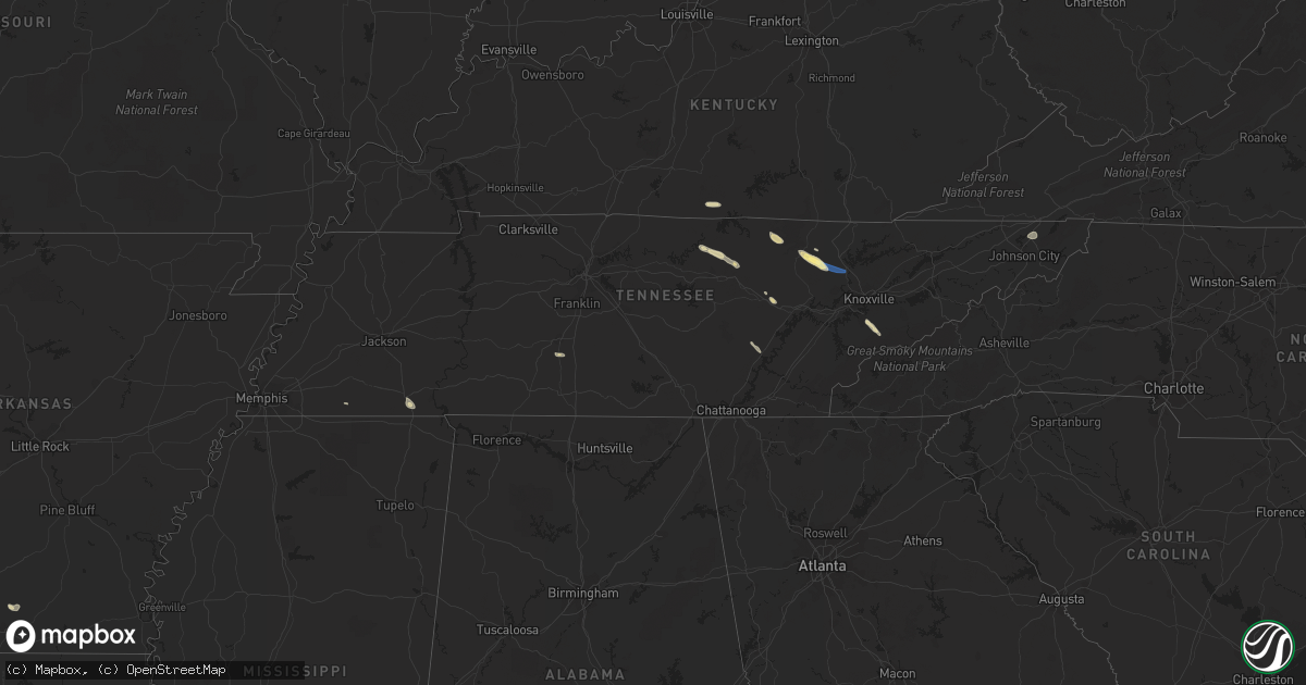
Hail Map in Tennessee on September 25, 2022
Get this storm
September 25 map
$229
one time, instant access
Download today. No call, no setup
Keep the $229
Bought the map and want the full workflow? Apply the entire $229 to a subscription within 7 days. None of it is wasted.
Every map, not just this one
This buys you this map. Subscription and you get every map we run, in the markets you choose from a few cities to whole states to nationwide. Plus real-time alerts the moment a storm fires.
Contact data
Name, contact info, occupancy, even credit band for addresses in the footprint. You go from where it hit to who to call.
Become the source they trust
Unlimited branding weather history reports on demand. You already have the documented answer ready for the property owner, and you are the one who showed up with it.
Property data and RoofTrace estimates
Pull up any address you have got, its value and the exact code rules for that jurisdiction, straight from One Click Code. Then RoofTrace estimates the squares, pitch, and roof value, priced the way you price.
Storm reports in Tennessee
Tennessee
| Date | Description |
|---|---|
| 09/25/20226:20 PM CDT | Photos of trees and several large branches blown down relayed via social media. |
| 09/25/20226:03 PM CDT | Several tree branches blown onto ground. Reported by trained spotter. |
| 09/25/20225:40 PM CDT | Multple large trees down in colonial heights neighborhood. |
| 09/25/20225:20 PM CDT | Multiple trees down off stanley valley road near the tn/va border. |
| 09/25/20224:55 PM CDT | Numerous trees down with time estimated from radar. |
| 09/25/20224:50 PM CDT | Numerous trees down with time estimated from radar. |
| 09/25/20224:40 PM CDT | Tree and powerlines down near norma with the time estimated from radar. |
| 09/25/20224:35 PM CDT | Numerous trees down with time estimated from radar. |
| 09/25/20222:41 AM CDT | At 740 PM EDT, a severe thunderstorm was located 14 miles north of Waynesville, or 7 miles northeast of Smoky Mountains-Cataloochee, moving southeast at 35 mph. HAZARD...60 mph wind gusts and penny size hail. SOURCE...Radar indicated. IMPACT...Expect damage to trees and power lines. Locations impacted include... Cove Creek, Luck, Fines Creek, Max Patch, Canto and Smoky Mountains-Cataloochee. |
| 09/25/202212:34 AM CDT | At 534 PM EDT, a severe thunderstorm was located 9 miles south of Huntsville, or 12 miles north of Wartburg, moving southeast at 35 mph. HAZARD...60 mph wind gusts and quarter size hail. SOURCE...Radar indicated. IMPACT...Hail damage to vehicles is expected. Expect wind damage to roofs, siding, and trees. Locations impacted include... Oliver Springs, Rocky Top, Sunbright, Smokey Junction, Rosedale, Norma, Frozen Head State Park, Slick Rock, Petros and Robbins.This includes Interstate 75 in Tennessee between mile markers 127 and130. |
| 09/24/202210:34 PM CDT | At 334 PM CDT, a severe thunderstorm was located near Rickman, or 7 miles southwest of Livingston, moving southeast at 30 mph. HAZARD...60 mph wind gusts and quarter size hail. SOURCE...Radar indicated. IMPACT...Hail damage to vehicles is expected. Expect wind damage to roofs, siding, and trees. Locations impacted include... Livingston, Monterey, Crawford and Rickman. This includes Interstate 40 between mile markers 301 and 302. |
All States Impacted by Hail Map on September 25, 2022
Cities Impacted by Hail Map on September 25, 2022
- Clarington, OH
- Friendsville, MD
- Crossville, TN
- Crab Orchard, TN
- Townsend, TN
- Maryville, TN
- Walland, TN
- Grand Junction, TN
- Greenville, TX
- Culleoka, TN
- Columbia, TN
- Lewisville, AR
- Fouke, AR
- Bradley, AR
- Garland City, AR
- Stamps, AR
- Magnolia, AR
- Mount Holly, AR
- El Dorado, AR
- Hampton, AR
- Texarkana, AR
- Ramer, TN
- Selmer, TN
- Williston Park, NY
- Albertson, NY
- East Meadow, NY
- Carle Place, NY
- Woodbury, NY
- Plainview, NY
- Hempstead, NY
- Roslyn, NY
- Roslyn Heights, NY
- Mineola, NY
- Hicksville, NY
- Garden City, NY
- Old Westbury, NY
- Glen Head, NY
- Westbury, NY
- Jericho, NY
- Syosset, NY
- Uniondale, NY
- West Hempstead, NY
- New Hyde Park, NY
- Manhasset, NY
- Piney Flats, TN
- Bluff City, TN
- Robbins, TN
- Guys, TN
- Jamestown, TN
- Accident, MD
- Grantsville, MD
- Burkesville, KY
- Tompkinsville, KY
- Cookeville, TN
- Livingston, TN
- Hilham, TN
- Camden, AR
- Huntsville, TN
- Sunbright, TN
- Roma, TX
- Burton, WV
- Fairview, WV
- Wana, WV
- Metz, WV
- Hundred, WV
- New Martinsville, WV
- Littleton, WV
- McHenry, MD
- Swanton, MD
- Chidester, AR
- Dayton, TN
- Gainesboro, TN
- Emory, TX
- Texarkana, TX
- Queen City, TX
- Windsor, NY
- Monterey, TN
- Rickman, TN
- Terrell, TX
- Quinlan, TX
- Wills Point, TX
- Stephens, AR
- Barton, MD
- Westernport, MD
- Rawlings, MD
- Bruceton Mills, WV
- Terra Alta, WV
- Bloomington, MD
- Briceville, TN
- Saltillo, TX
- Ridgeley, WV
- Keyser, WV
- Proctor, WV
- Louann, AR
- Ozan, AR
- Kirkwood, NY
- Zapata, TX
- Okolona, AR
- Oakland, MD
- Lone Oak, TX
- Mount Vernon, TX
- Pikeville, TN
- Points, WV
- Paw Paw, WV
- Slanesville, WV
- Capon Bridge, WV
- Maidsville, WV
- Rivesville, WV
- Morgantown, WV
- Fort Lee, VA
- Williamsburg, VA
- Hopewell, VA
- Colonial Heights, VA
- Charles City, VA
- Blackstone, VA
- Sutherland, VA
- Petersburg, VA
- Church Road, VA
- Wilsons, VA
- Disputanta, VA
- Ford, VA
- Spring Grove, VA
- Prince George, VA
- Augusta, WV
- Star Tannery, VA
- Delray, WV
- Winchester, VA
- Romney, WV
- Boyce, VA
- Rio, WV
- Shanks, WV
- Clear Brook, VA
- Moorefield, WV
- Stephens City, VA
- Strasburg, VA
- Berryville, VA
- Baker, WV
- Yellow Spring, WV
- Gore, VA
- Wardensville, WV
- High View, WV
- Lonaconing, MD
- Albright, WV
- Granville, WV
- Springfield, WV
- Levels, WV
- Cross Junction, VA
- Bloomery, WV
- Caryville, TN
- Clinton, TN
- Rocky Top, TN


