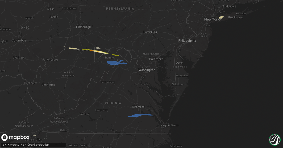
Hail Map in Maryland on September 25, 2022
Get this storm
September 25 map
$229
one time, instant access
Download today. No call, no setup
Keep the $229
Bought the map and want the full workflow? Apply the entire $229 to a subscription within 7 days. None of it is wasted.
Every map, not just this one
This buys you this map. Subscription and you get every map we run, in the markets you choose from a few cities to whole states to nationwide. Plus real-time alerts the moment a storm fires.
Contact data
Name, contact info, occupancy, even credit band for addresses in the footprint. You go from where it hit to who to call.
Become the source they trust
Unlimited branding weather history reports on demand. You already have the documented answer ready for the property owner, and you are the one who showed up with it.
Property data and RoofTrace estimates
Pull up any address you have got, its value and the exact code rules for that jurisdiction, straight from One Click Code. Then RoofTrace estimates the squares, pitch, and roof value, priced the way you price.
Storm reports in Maryland
Maryland
| Date | Description |
|---|---|
| 09/25/20221:03 PM CDT | Tree down blocking both lanes of mason dixon road at west heaps road. |
| 09/25/202210:22 AM CDT | A local report indicates 1.00 inch wind near BARTON |
| 09/25/202210:03 AM CDT | A local report indicates 1.50 inch wind near 2 NNE MC HENRY |
| 09/25/202210:01 AM CDT | A local report indicates 1.00 inch wind near 2 N MC HENRY |
| 09/25/20226:20 AM CDT | At 1120 AM EDT, a severe thunderstorm was located near Westernport, moving east at 45 mph. HAZARD...60 mph wind gusts and quarter size hail. SOURCE...Radar indicated. IMPACT...Damaging winds will cause some trees and large branches to fall. This could injure those outdoors, as well as damage homes and vehicles. Roadways may become blocked by downed trees. Localized power outages are possible. Unsecured light objects may become projectiles. Locations impacted include... Cumberland, Westernport, Bel Air, Fort Ashby, Lonaconing, Piedmont, Cresaptown, Potomac Park, Wiley Ford, Rawlings, Springfield, Barton, Midland, Midlothian, Franklin, Green Spring, Woodland, Oldtown, Luke and Spring Gap. |
| 09/25/20225:58 AM CDT | At 1058 AM EDT, a severe thunderstorm was located near Friendsville, or 10 miles west of Bittinger, moving east at 45 mph. HAZARD...60 mph wind gusts and quarter size hail. SOURCE...Radar indicated. IMPACT...Damaging winds will cause some trees and large branches to fall. This could injure those outdoors, as well as damage homes and vehicles. Roadways may become blocked by downed trees. Localized power outages are possible. Unsecured light objects may become projectiles. Locations impacted include... Bittinger, Accident, Deep Creek Lake State Park, Merrill, McHenry, Big Run State Park, New Germany and Jennings. |
| 09/24/202211:55 PM CDT | At 455 PM EDT, a severe thunderstorm was located over South River, moving east at 40 mph. HAZARD...60 mph wind gusts and penny size hail. SOURCE...Radar indicated. IMPACT...Damage to roofs, siding, trees, and power lines is possible. Locations impacted include... Easton, Talbot, St. Michaels, Chester, Grasonville, Copperville, Queenstown and Stevensville South. |
| 09/24/202211:46 PM CDT | At 446 PM EDT, a severe thunderstorm was located over Rhode River, moving east at 35 mph. HAZARD...60 mph wind gusts and quarter size hail. SOURCE...Radar indicated. IMPACT...Damaging winds will cause some trees and large branches to fall. This could injure those outdoors, as well as damage homes and vehicles. Roadways may become blocked by downed trees. Localized power outages are possible. Unsecured light objects may become projectiles. Locations impacted include... Annapolis, Mayo, Shady Side, Rhode River, South River, Londontowne, Edgewater, Riva, Galesville, Highland Beach, Hillsmere Shores, Harwood, West River, Lothian, Davidsonville, Bay Ridge and Edgewater Beach. |
| 09/24/20228:53 PM CDT | At 153 PM EDT, a severe thunderstorm was located near Railroad, or 14 miles southeast of Parkville, moving east at 50 mph. HAZARD...60 mph wind gusts. SOURCE...Radar indicated. IMPACT...Damaging winds will cause some trees and large branches to fall. This could injure those outdoors, as well as damage homes and vehicles. Roadways may become blocked by downed trees. Localized power outages are possible. Unsecured light objects may become projectiles. Locations impacted include... Jarrettsville, Rising Sun, West Nottingham, Octoraro, Richardsmere, Woodlawn, Conowingo, Rock Springs, Farmington, Pylesville, Port Deposit, Darlington, Cardiff, Freeland, Norrisville, Bentley Springs, Street, Monkton, Whiteford and Scarboro. |
| 09/24/20228:39 PM CDT | At 139 PM EDT, severe thunderstorms were located along a line extending from near Inwood to near Millwood Pike to near Stephens City, moving east at 55 mph. HAZARD...70 mph wind gusts and quarter size hail. SOURCE...Radar indicated. IMPACT...Damaging winds will cause some trees and large branches to fall. This could injure those outdoors, as well as damage homes and vehicles. Roadways may become blocked by downed trees. Localized power outages are possible. Unsecured light objects may become projectiles. Locations impacted include... Germantown, Leesburg, Winchester, Herndon, Broadlands, Lansdowne, Lowes Island, Brambleton, Charles Town, Poolesville, Millwood Pike, Dulles International Airport, Ashburn, Sterling, Ballenger Creek, Countryside, Purcellville, Brunswick, Ranson and Berryville. |
All States Impacted by Hail Map on September 25, 2022
Cities Impacted by Hail Map on September 25, 2022
- Clarington, OH
- Friendsville, MD
- Crossville, TN
- Crab Orchard, TN
- Townsend, TN
- Maryville, TN
- Walland, TN
- Grand Junction, TN
- Greenville, TX
- Culleoka, TN
- Columbia, TN
- Lewisville, AR
- Fouke, AR
- Bradley, AR
- Garland City, AR
- Stamps, AR
- Magnolia, AR
- Mount Holly, AR
- El Dorado, AR
- Hampton, AR
- Texarkana, AR
- Ramer, TN
- Selmer, TN
- Williston Park, NY
- Albertson, NY
- East Meadow, NY
- Carle Place, NY
- Woodbury, NY
- Plainview, NY
- Hempstead, NY
- Roslyn, NY
- Roslyn Heights, NY
- Mineola, NY
- Hicksville, NY
- Garden City, NY
- Old Westbury, NY
- Glen Head, NY
- Westbury, NY
- Jericho, NY
- Syosset, NY
- Uniondale, NY
- West Hempstead, NY
- New Hyde Park, NY
- Manhasset, NY
- Piney Flats, TN
- Bluff City, TN
- Robbins, TN
- Guys, TN
- Jamestown, TN
- Accident, MD
- Grantsville, MD
- Burkesville, KY
- Tompkinsville, KY
- Cookeville, TN
- Livingston, TN
- Hilham, TN
- Camden, AR
- Huntsville, TN
- Sunbright, TN
- Roma, TX
- Burton, WV
- Fairview, WV
- Wana, WV
- Metz, WV
- Hundred, WV
- New Martinsville, WV
- Littleton, WV
- McHenry, MD
- Swanton, MD
- Chidester, AR
- Dayton, TN
- Gainesboro, TN
- Emory, TX
- Texarkana, TX
- Queen City, TX
- Windsor, NY
- Monterey, TN
- Rickman, TN
- Terrell, TX
- Quinlan, TX
- Wills Point, TX
- Stephens, AR
- Barton, MD
- Westernport, MD
- Rawlings, MD
- Bruceton Mills, WV
- Terra Alta, WV
- Bloomington, MD
- Briceville, TN
- Saltillo, TX
- Ridgeley, WV
- Keyser, WV
- Proctor, WV
- Louann, AR
- Ozan, AR
- Kirkwood, NY
- Zapata, TX
- Okolona, AR
- Oakland, MD
- Lone Oak, TX
- Mount Vernon, TX
- Pikeville, TN
- Points, WV
- Paw Paw, WV
- Slanesville, WV
- Capon Bridge, WV
- Maidsville, WV
- Rivesville, WV
- Morgantown, WV
- Fort Lee, VA
- Williamsburg, VA
- Hopewell, VA
- Colonial Heights, VA
- Charles City, VA
- Blackstone, VA
- Sutherland, VA
- Petersburg, VA
- Church Road, VA
- Wilsons, VA
- Disputanta, VA
- Ford, VA
- Spring Grove, VA
- Prince George, VA
- Augusta, WV
- Star Tannery, VA
- Delray, WV
- Winchester, VA
- Romney, WV
- Boyce, VA
- Rio, WV
- Shanks, WV
- Clear Brook, VA
- Moorefield, WV
- Stephens City, VA
- Strasburg, VA
- Berryville, VA
- Baker, WV
- Yellow Spring, WV
- Gore, VA
- Wardensville, WV
- High View, WV
- Lonaconing, MD
- Albright, WV
- Granville, WV
- Springfield, WV
- Levels, WV
- Cross Junction, VA
- Bloomery, WV
- Caryville, TN
- Clinton, TN
- Rocky Top, TN


