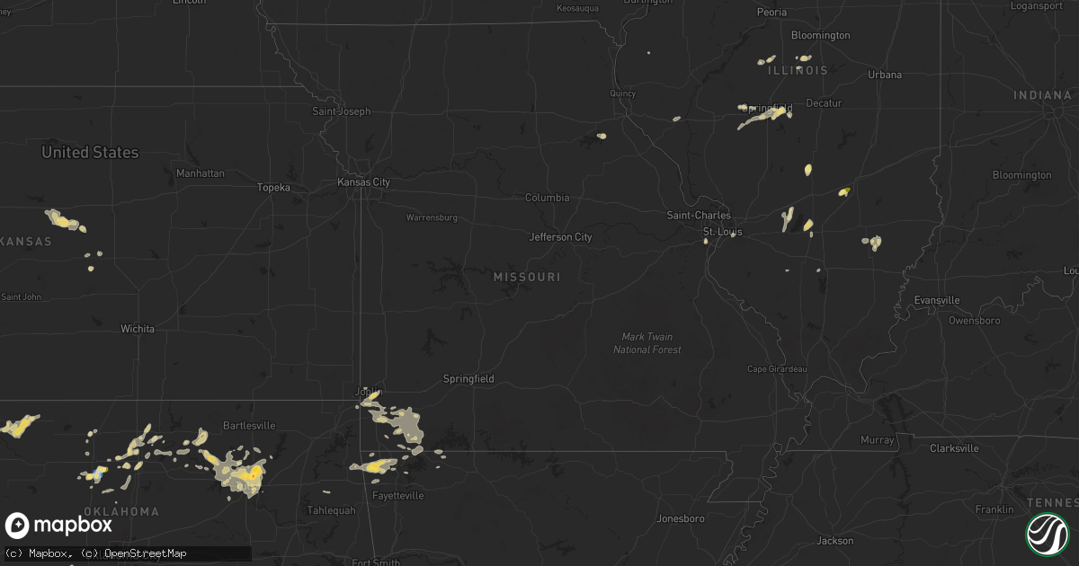
Hail Map in Missouri on September 20, 2025
Get this storm
September 20 map
$229
one time, instant access
Download today. No call, no setup
Keep the $229
Bought the map and want the full workflow? Apply the entire $229 to a subscription within 7 days. None of it is wasted.
Every map, not just this one
This buys you this map. Subscription and you get every map we run, in the markets you choose from a few cities to whole states to nationwide. Plus real-time alerts the moment a storm fires.
Contact data
Name, contact info, occupancy, even credit band for addresses in the footprint. You go from where it hit to who to call.
Become the source they trust
Unlimited branding weather history reports on demand. You already have the documented answer ready for the property owner, and you are the one who showed up with it.
Property data and RoofTrace estimates
Pull up any address you have got, its value and the exact code rules for that jurisdiction, straight from One Click Code. Then RoofTrace estimates the squares, pitch, and roof value, priced the way you price.
Storm reports in Missouri
Missouri
| Date | Description |
|---|---|
| 09/19/202511:20 PM CDT | A tree down in the area of highway 97 and state highway b and highway t. |
| 09/19/202510:40 PM CDT | Hail to the size of quarters fell at highway 37 and farm road 2212. |
| 09/19/202510:15 PM CDT | A tree was down due to thunderstorm winds on highway 76 at farm road 2150. |
All States Impacted by Hail Map on September 20, 2025
Cities Impacted by Hail Map on September 20, 2025
- Rose, OK
- Hulbert, OK
- Peggs, OK
- Tahlequah, OK
- Pleasant Plains, IL
- New Berlin, IL
- Carlyle, IL
- Atlanta, IL
- McLean, IL
- Sandoval, IL
- Patoka, IL
- Waverly, IL
- Winnsboro, SC
- Odin, IL
- Springfield, IL
- Waynesville, IL
- Chatham, IL
- Loami, IL
- Caldwell, OH
- Hendersonville, NC
- Altamont, IL
- Mason, IL
- Fenton, MO
- Saint Louis, MO
- Centralia, IL
- Majestic, KY
- Greenville, IL
- Rochester, IL
- Graysville, PA
- Keyesport, IL
- Henrico, VA
- Lindon, CO
- Matewan, WV
- East Saint Louis, IL
- Fairview Heights, IL
- Belleville, IL
- Edinburg, IL
- Monroe City, MO
- Dawson, IL
- Mechanicsburg, IL
- Smithboro, IL
- Perry, MO
- Center, MO
- Hillsboro, NM
- Mount Auburn, IL
- Cumberland, OH
- Caseyville, IL
- Necedah, WI
- Watson, IL
- Ridge Spring, SC
- Johnston, SC
- Pocahontas, IL
- Mcconnelsville, OH
- Mason City, IL
- Emden, IL
- San Jose, IL
- Lore City, OH
- Easton, IL
- Bellaire, OH
- Bridgeport, OH
- Limon, CO
- Balko, OK
- Beaver, OK
- Stockport, OH
- Laverne, OK
- Beason, IL
- Lincoln, IL
- Matheson, CO
- Cambridge, OH
- Saint Clairsville, OH
- New Concord, OH
- Carnegie, OK
- Apache, OK
- Carmichaels, PA
- Mount Morris, PA
- Ramsey, IL
- Bingham, IL
- Oconee, IL
- Nekoosa, WI
- Waurika, OK
- Fort Cobb, OK
- Maidsville, WV
- Wisconsin Rapids, WI
- Hastings, OK
- Dilliner, PA
- Morgantown, WV
- Comanche, OK
- Temple, OK
- Fairfield, IL
- Anadarko, OK
- Folsom, NM
- Greensboro, PA
- Granville, WV
- Gate, OK
- Bobtown, PA
- Stevens Point, WI
- Griggsville, IL
- Cope, CO
- Walters, OK
- Wild Rose, WI
- Wautoma, WI
- Cisne, IL
- Mount Erie, IL
- Trevor, WI
- Salem, WI
- Pana, IL
- Duncan, OK
- Grenville, NM
- Ohiopyle, PA
- Chalk Hill, PA
- Farmington, PA
- Flagler, CO
- Waupaca, WI
- Gracemont, OK
- Binger, OK
- Seibert, CO
- Hardesty, OK
- Minco, OK
- Piney Flats, TN
- Woodward, OK
- Fort Supply, OK
- Amarillo, TX
- Antioch, IL
- Crescent, OK
- Mooreland, OK
- Johnsonville, IL
- Clay City, IL
- Marlow, OK
- Ramah, CO
- Fairmont, OK
- Enid, OK
- Covington, OK
- Fremont, WI
- Burlington, WI
- Hennessey, OK
- Meade, KS
- Lake Geneva, WI
- Genoa City, WI
- Panhandle, TX
- Dowagiac, MI
- Bristol, WI
- Claude, TX
- Cassopolis, MI
- Clarington, OH
- Spearman, TX
- Vici, OK
- Nashville, IL
- Kansasville, WI
- Hortonville, WI
- New London, WI
- Newburg, WV
- Tunnelton, WV
- Marshall, OK
- Perry, OK
- Larsen, WI
- Freedom, OK
- Orlando, OK
- Allegan, MI
- Silver Lake, WI
- Bison, OK
- Shattuck, OK
- Ringwood, OK
- Garber, OK
- Vandalia, MI
- Terra Alta, WV
- Indiahoma, OK
- Marcellus, MI
- Rowlesburg, WV
- Snyder, OK
- Loveland, OK
- Frederick, OK
- Billings, OK
- Lucien, OK
- Waukomis, OK
- Jones, MI
- Perryton, TX
- Cache, OK
- Drummond, OK
- Douglas, OK
- Fargo, OK
- Sharon, OK
- Groom, TX
- Lawton, OK
- Red Rock, OK
- Marland, OK
- Medicine Park, OK
- Hominy, OK
- Ralston, OK
- Oologah, OK
- Collinsville, OK
- Ordway, CO
- Fennville, MI
- Holland, MI
- Hamilton, MI
- Hopkins, MI
- Hobart, OK
- Waltonville, IL
- Mount Vernon, IL
- Canadian, TX
- Pawnee, OK
- Tonkawa, OK
- Carthage, IL
- Fairfax, OK
- Pond Creek, OK
- Ravenna, MI
- Skiatook, OK
- Ponca City, OK
- Dorr, MI
- Gotebo, OK
- Barnsdall, OK
- Higgins, TX
- Trinidad, CO
- Branson, CO
- Sperry, OK
- Waynoka, OK
- Owasso, OK
- Burbank, OK
- Pawhuska, OK
- Stella, MO
- Fairview, MO
- Decatur, MI
- Tulsa, OK
- Alva, OK
- Wheaton, MO
- Neosho, MO
- Seneca, MO
- Quapaw, OK
- Model, CO
- Prue, OK
- Osage, OK
- Talala, OK
- Ramona, OK
- Granby, MO
- Purdy, MO
- Goodman, MO
- Sand Springs, OK
- Cleveland, OK
- Mannford, OK
- Akron, CO
- Cassville, MO
- Rocky Comfort, MO
- Washburn, MO
- Exeter, MO
- Sapulpa, OK
- Catoosa, OK
- Fritch, TX
- Pierce City, MO
- Monett, MO
- Stark City, MO
- Broken Arrow, OK
- Joplin, MO
- Pritchett, CO
- Carthage, MO
- Diamond, MO
- Memphis, TX
- Jay, OK
- Decatur, AR
- Hiwasse, AR
- Gravette, AR
- Sulphur Springs, AR
- Bella Vista, AR
- Bentonville, AR
- Gentry, AR
- Duenweg, MO
- Las Animas, CO
- Colcord, OK
- Centerton, AR
- Butterfield, MO
- Rogers, AR
- Seligman, MO
- White Deer, TX
- Maysville, AR
- Jenks, OK
- Garfield, AR
- Clarendon, TX
- Shamrock, TX
- Hindsville, AR
- Pea Ridge, AR
- Eagle Rock, MO
- Golden, MO
- Eureka Springs, AR
- Berryville, AR
- Pampa, TX
- Huntsville, AR
- Copeland, KS
- Montezuma, KS
- Cimarron, KS
- Siloam Springs, AR
- Anderson, MO
- Lowell, AR
- Ingalls, KS
- Garden City, KS
- Childress, TX
- Inman, KS
- Wilson, KS
- Ellsworth, KS
- Dyersburg, TN
- Little River, KS
- Hays, KS
- Windom, KS
- Kanopolis, KS
- Marquette, KS
- Geneseo, KS
- Cheyenne, OK
- Mcpherson, KS


