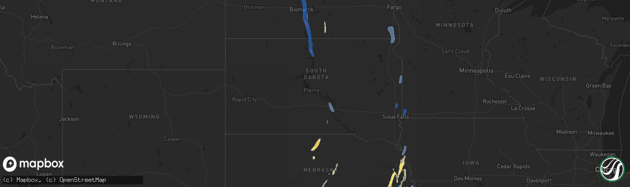
Hail Map in South Dakota on September 14, 2025
The weather event in South Dakota on September 14, 2025 includes Tornado, Hail, and Wind maps. 13 states and 367 cities were impacted and suffered possible damage. The total estimated number of properties impacted is 0.
Want more than just the map?
Turn this storm into a full workflow.
- Owner + property data so you know who to knock
- OnDemand branded weather history reports to win the "did we even have hail?" argument
- RoofTrace estimate so reps stop guessing numbers at the door
Bought this map? Upgrade within 7 days and we'll credit the $230. (10-15 min setup call)
Tornado
Hail
Wind
0
Estimated number of impacted properties by a 1.00" hail or larger0
Estimated number of impacted properties by a 1.75" hail or larger0
Estimated number of impacted properties by a 2.50" hail or largerStorm reports in South Dakota
South Dakota
| Date | Description |
|---|---|
| 09/14/20256:55 PM CDT | Mesonet station ocms2 oacoma 2w |
| 09/14/20255:10 PM CDT | Personal weather station. |
| 09/14/20254:45 PM CDT | Thunderstorm wind gusts knocked over lawn furniture and broke 2 to 4 inch tree branches down. |
| 09/14/20254:26 PM CDT | Mesonet station 58 victor |
| 09/14/20254:21 PM CDT | Mesonet station 58 victor |
| 09/14/20254:11 PM CDT | Personal weather station. |
| 09/14/20253:49 PM CDT | Mesonet station 2 lake city |
| 09/14/20252:53 PM CDT | Asos station katy watertown muni ap. |
| 09/14/20251:15 PM CDT | Time estimated. |
| 09/14/202512:45 PM CDT | Winds estimated to be 60-70 mph. Time estimated. |
| 09/14/202512:43 PM CDT | Report on social media of suv with trailer flipped on highway 12 and powerlines down from tornado east of mobridge. Time estimated by radar. |
All States Impacted by Hail Map on September 14, 2025
Cities Impacted by Hail Map on September 14, 2025
- Mobridge, SD
- Cannon Ball, ND
- Linton, ND
- Daykin, NE
- Gilead, NE
- Hebron, NE
- Ohiowa, NE
- Western, NE
- Tobias, NE
- Alexandria, NE
- Mound City, SD
- Hazelton, ND
- Strasburg, ND
- Fort Yates, ND
- Wakpala, SD
- Glenham, SD
- Eagle Butte, SD
- Pollock, SD
- Mandan, ND
- Livermore, KY
- Centertown, KY
- Hartford, KY
- Saint Francis, KS
- West Point, NE
- Oakland, NE
- Munden, KS
- Hubbell, NE
- Chester, NE
- Belvidere, NE
- Scribner, NE
- Seward, NE
- Curtis, NE
- Milligan, NE
- Friend, NE
- Bismarck, ND
- Staplehurst, NE
- Parks, NE
- Gothenburg, NE
- Hooper, NE
- Dorchester, NE
- Beaver Crossing, NE
- Goehner, NE
- Ulysses, NE
- Cordova, NE
- Rosalie, NE
- Dwight, NE
- Lyons, NE
- Milford, NE
- Utica, NE
- Fairbury, NE
- Exeter, NE
- David City, NE
- Brainard, NE
- Sergeant Bluff, IA
- Homer, NE
- Sioux City, IA
- Dakota City, NE
- South Sioux City, NE
- Hinton, IA
- Wauneta, NE
- Endicott, NE
- Walthill, NE
- Palisade, NE
- Menoken, ND
- Cedar Bluffs, NE
- Farnam, NE
- Moorefield, NE
- Callaway, NE
- Macy, NE
- Linwood, NE
- Bruno, NE
- Haviland, KS
- Ellington, MO
- Baldwin, ND
- Rogers, NE
- Morse Bluff, NE
- North Bend, NE
- Dodge, NE
- Brady, NE
- Ames, NE
- Winnebago, NE
- Sloan, IA
- Salix, IA
- Bee, NE
- Abie, NE
- Schuyler, NE
- Trenton, NE
- Wing, ND
- Snyder, NE
- Martell, NE
- Lincoln, NE
- Broken Bow, NE
- Cozad, NE
- North Platte, NE
- Hayes Center, NE
- Prague, NE
- Denton, NE
- Beemer, NE
- Butte, ND
- Merna, NE
- Willow Island, NE
- McCook, NE
- Bancroft, NE
- Shattuck, OK
- Fargo, OK
- Hedley, TX
- Memphis, TX
- Stockville, NE
- Indianola, NE
- Denhoff, ND
- Voltaire, ND
- Balfour, ND
- Hoxie, KS
- Mount Vernon, IL
- Waltonville, IL
- Bonnie, IL
- Salem, MO
- Wishek, ND
- Zeeland, ND
- Wellington, TX
- Ceresco, NE
- Davey, NE
- Iberia, MO
- Golconda, IL
- Lakeview, TX
- Dell Rapids, SD
- Trent, SD
- Egan, SD
- Beaver Creek, MN
- Hills, MN
- Luverne, MN
- Hardwick, MN
- Jasper, MN
- New Effington, SD
- Sisseton, SD
- Rosholt, SD
- Fairmount, ND
- Hankinson, ND
- Wahpeton, ND
- Mantador, ND
- Mooreton, ND
- Barney, ND
- Wyndmere, ND
- Wilton, ND
- Karlsruhe, ND
- La Vista, NE
- Papillion, NE
- Omaha, NE
- Oberlin, KS
- Clayton, IL
- Hamilton, KS
- Decatur, NE
- Wahoo, NE
- Oconto, NE
- Childress, TX
- Pingree, ND
- Sargent, NE
- Fremont, NE
- Mead, NE
- Colon, NE
- Anselmo, NE
- Dresden, KS
- Jennings, KS
- Danbury, NE
- Butler, IL
- Selden, KS
- Greenville, MO
- Du Bois, IL
- Ashley, IL
- Eureka, KS
- Greenville, IL
- Sorento, IL
- Royalton, IL
- Metropolis, IL
- Napoleon, ND
- Mulkeytown, IL
- Lexington, NE
- Turtle Lake, ND
- Mercer, ND
- Carrington, ND
- Booker, TX
- Lake City, KS
- Litchfield, IL
- Burwell, NE
- Taylor, NE
- Olpe, KS
- Carterville, IL
- Scheller, IL
- Nickerson, NE
- Arlington, NE
- Madison, KS
- Emporia, KS
- Hartford, KS
- Neosho Rapids, KS
- Ithaca, NE
- Dodson, TX
- Johnstown, NE
- Elsmere, NE
- Wood Lake, NE
- Jacksonville, IL
- Alexander, IL
- Follett, TX
- De Soto, IL
- Herman, NE
- Tekamah, NE
- Craig, NE
- Vergennes, IL
- Elwood, NE
- Blair, NE
- Eustis, NE
- Reading, KS
- Admire, KS
- Astoria, SD
- Brandt, SD
- Gary, SD
- New Rockford, ND
- Grace City, ND
- Glenfield, ND
- Mchenry, ND
- Williamsville, MO
- Murphysboro, IL
- Saint Jacob, IL
- Norcatur, KS
- Norton, KS
- Clayton, KS
- Seminole, TX
- Carbondale, IL
- Higgins, TX
- Laverne, OK
- Tamaroa, IL
- Eddyville, NE
- Cathay, ND
- Plainville, KS
- Ellis, KS
- Hays, KS
- Lipscomb, TX
- Smithfield, NE
- Warwick, ND
- Protection, KS
- Springview, NE
- Arapahoe, NE
- Edison, NE
- Bertrand, NE
- Drake, ND
- Sumner, NE
- Morland, KS
- New Baden, IL
- Mullinville, KS
- Fairdealing, MO
- Harviell, MO
- Grandin, MO
- Loomis, NE
- Atlanta, NE
- Quinter, KS
- Doniphan, MO
- Arnett, OK
- Ellsinore, MO
- Pomona, IL
- Canadian, TX
- Moro, IL
- Oxford, NE
- Orleans, NE
- Alma, NE
- Holdrege, NE
- Miami, TX
- Phillipsburg, KS
- Rockwood, IL
- Jacob, IL
- Campbell Hill, IL
- Glade, KS
- Ava, IL
- Gorham, IL
- Collyer, KS
- Penokee, KS
- Harrisburg, IL
- Mason City, NE
- Republican City, NE
- Devils Lake, ND
- Hill City, KS
- Winner, SD
- Van Horn, TX
- Pinckneyville, IL
- Greensburg, KS
- Granville, ND
- Oacoma, SD
- Reliance, SD
- Chamberlain, SD
- Cadiz, KY
- Wilcox, NE
- Benton, IL
- Stockton, KS
- Cutler, IL
- Funk, NE
- Colome, SD
- Agra, KS
- Hildreth, NE
- Naponee, NE
- Sparta, IL
- Coulterville, IL
- Cottage Grove, TN
- Puryear, TN
- Paris, TN
- Wakeeney, KS
- Lower Brule, SD
- Dallas, SD
- Bloomington, NE
- Pocahontas, AR
- Minden, NE
- Odin, IL
- Murray, KY
- Dexter, KY
- Axtell, NE
- Sandoval, IL
- Centralia, IL
- Christopher, IL
- Sesser, IL
- Palmersville, TN
- Upland, NE
- Hampden, ND
- Kensington, KS
- Henry, TN
- Alsen, ND
- Wales, ND
- Grand Chain, IL
- Kirwin, KS
- Gaylord, KS
- Cedar, KS
- Park, KS
- Percy, IL
- Wickliffe, KY
- La Center, KY
- Kevil, KY
- Perryton, TX
- Hannah, ND
- Boaz, KY
- Bardwell, KY
- Lebanon, KS
- Smith Center, KS
- Arlington, KY
- Hickory, KY
- Natoma, KS
- Mayfield, KY
- Fancy Farm, KY
- Clinton, KY
- Marble Hill, MO
- Symsonia, KY
- Benton, KY
- Leopold, MO
- Wingo, KY
- Fulton, KY
- Hickman, KY
- Columbus, KY
- Union City, TN
- South Fulton, TN
- Charleston, MO
- Sikeston, MO
- East Prairie, MO
- Matthews, MO
- Anniston, MO
- Essex, MO
- Centerville, TN
- Nunnelly, TN
- Puxico, MO
- Lowndes, MO
- Wappapello, MO
- Duke, OK
- Mangum, OK


