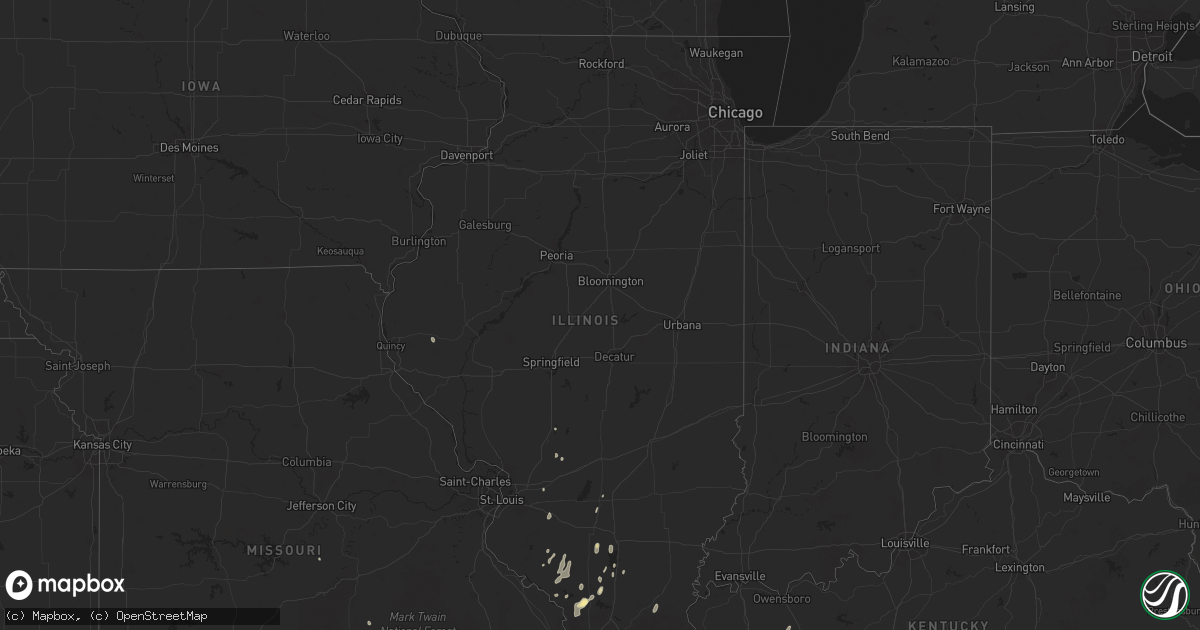
Hail Map in Illinois on September 14, 2025
Get this storm
September 14 map
$229
one time, instant access
Download today. No call, no setup
Keep the $229
Bought the map and want the full workflow? Apply the entire $229 to a subscription within 7 days. None of it is wasted.
Every map, not just this one
This buys you this map. Subscription and you get every map we run, in the markets you choose from a few cities to whole states to nationwide. Plus real-time alerts the moment a storm fires.
Contact data
Name, contact info, occupancy, even credit band for addresses in the footprint. You go from where it hit to who to call.
Become the source they trust
Unlimited branding weather history reports on demand. You already have the documented answer ready for the property owner, and you are the one who showed up with it.
Property data and RoofTrace estimates
Pull up any address you have got, its value and the exact code rules for that jurisdiction, straight from One Click Code. Then RoofTrace estimates the squares, pitch, and roof value, priced the way you price.
Storm reports in Illinois
Illinois
| Date | Description |
|---|---|
| 09/14/20256:14 PM CDT | Tree knocked down along highway 127 near etherton. |
| 09/14/20256:08 PM CDT | A tree was blown down across pump house rd just north of chautauqua rd. |
| 09/14/20256:05 PM CDT | Quarter size hail reported on the west side of carbondale. |
| 09/14/20256:04 PM CDT | A large tree fell through a mobile home on new era road just north of highway 13. |
| 09/14/20256:03 PM CDT | Trees down along country club road near the murphysboro walmart. Also knocked the power out to the surrounding area. Time estimated from radar. |
| 09/14/20254:47 PM CDT | A tree was blown down along i-57 south of benton. |
| 09/14/20254:41 PM CDT | Hail up to the size of quarters was reported in benton. |
| 09/14/20254:35 PM CDT | A couple of trees were blown down in the south marcum campground on rend lake. |
| 09/13/20257:40 PM CDT | A couple of trees blown down. Wind speed estimated at 50-60 mph. |
| 09/13/20257:40 PM CDT | A couple |
All States Impacted by Hail Map on September 14, 2025
Cities Impacted by Hail Map on September 14, 2025
- Mobridge, SD
- Cannon Ball, ND
- Linton, ND
- Daykin, NE
- Gilead, NE
- Hebron, NE
- Ohiowa, NE
- Western, NE
- Tobias, NE
- Alexandria, NE
- Mound City, SD
- Hazelton, ND
- Strasburg, ND
- Fort Yates, ND
- Wakpala, SD
- Glenham, SD
- Eagle Butte, SD
- Pollock, SD
- Mandan, ND
- Livermore, KY
- Centertown, KY
- Hartford, KY
- Saint Francis, KS
- West Point, NE
- Oakland, NE
- Munden, KS
- Hubbell, NE
- Chester, NE
- Belvidere, NE
- Scribner, NE
- Seward, NE
- Curtis, NE
- Milligan, NE
- Friend, NE
- Bismarck, ND
- Staplehurst, NE
- Parks, NE
- Gothenburg, NE
- Hooper, NE
- Dorchester, NE
- Beaver Crossing, NE
- Goehner, NE
- Ulysses, NE
- Cordova, NE
- Rosalie, NE
- Dwight, NE
- Lyons, NE
- Milford, NE
- Utica, NE
- Fairbury, NE
- Exeter, NE
- David City, NE
- Brainard, NE
- Sergeant Bluff, IA
- Homer, NE
- Sioux City, IA
- Dakota City, NE
- South Sioux City, NE
- Hinton, IA
- Wauneta, NE
- Endicott, NE
- Walthill, NE
- Palisade, NE
- Menoken, ND
- Cedar Bluffs, NE
- Farnam, NE
- Moorefield, NE
- Callaway, NE
- Macy, NE
- Linwood, NE
- Bruno, NE
- Haviland, KS
- Ellington, MO
- Baldwin, ND
- Rogers, NE
- Morse Bluff, NE
- North Bend, NE
- Dodge, NE
- Brady, NE
- Ames, NE
- Winnebago, NE
- Sloan, IA
- Salix, IA
- Bee, NE
- Abie, NE
- Schuyler, NE
- Trenton, NE
- Wing, ND
- Snyder, NE
- Martell, NE
- Lincoln, NE
- Broken Bow, NE
- Cozad, NE
- North Platte, NE
- Hayes Center, NE
- Prague, NE
- Denton, NE
- Beemer, NE
- Butte, ND
- Merna, NE
- Willow Island, NE
- McCook, NE
- Bancroft, NE
- Shattuck, OK
- Fargo, OK
- Hedley, TX
- Memphis, TX
- Stockville, NE
- Indianola, NE
- Denhoff, ND
- Voltaire, ND
- Balfour, ND
- Hoxie, KS
- Mount Vernon, IL
- Waltonville, IL
- Bonnie, IL
- Salem, MO
- Wishek, ND
- Zeeland, ND
- Wellington, TX
- Ceresco, NE
- Davey, NE
- Iberia, MO
- Golconda, IL
- Lakeview, TX
- Dell Rapids, SD
- Trent, SD
- Egan, SD
- Beaver Creek, MN
- Hills, MN
- Luverne, MN
- Hardwick, MN
- Jasper, MN
- New Effington, SD
- Sisseton, SD
- Rosholt, SD
- Fairmount, ND
- Hankinson, ND
- Wahpeton, ND
- Mantador, ND
- Mooreton, ND
- Barney, ND
- Wyndmere, ND
- Wilton, ND
- Karlsruhe, ND
- La Vista, NE
- Papillion, NE
- Omaha, NE
- Oberlin, KS
- Clayton, IL
- Hamilton, KS
- Decatur, NE
- Wahoo, NE
- Oconto, NE
- Childress, TX
- Pingree, ND
- Sargent, NE
- Fremont, NE
- Mead, NE
- Colon, NE
- Anselmo, NE
- Dresden, KS
- Jennings, KS
- Danbury, NE
- Butler, IL
- Selden, KS
- Greenville, MO
- Du Bois, IL
- Ashley, IL
- Eureka, KS
- Greenville, IL
- Sorento, IL
- Royalton, IL
- Metropolis, IL
- Napoleon, ND
- Mulkeytown, IL
- Lexington, NE
- Turtle Lake, ND
- Mercer, ND
- Carrington, ND
- Booker, TX
- Lake City, KS
- Litchfield, IL
- Burwell, NE
- Taylor, NE
- Olpe, KS
- Carterville, IL
- Scheller, IL
- Nickerson, NE
- Arlington, NE
- Madison, KS
- Emporia, KS
- Hartford, KS
- Neosho Rapids, KS
- Ithaca, NE
- Dodson, TX
- Johnstown, NE
- Elsmere, NE
- Wood Lake, NE
- Jacksonville, IL
- Alexander, IL
- Follett, TX
- De Soto, IL
- Herman, NE
- Tekamah, NE
- Craig, NE
- Vergennes, IL
- Elwood, NE
- Blair, NE
- Eustis, NE
- Reading, KS
- Admire, KS
- Astoria, SD
- Brandt, SD
- Gary, SD
- New Rockford, ND
- Grace City, ND
- Glenfield, ND
- Mchenry, ND
- Williamsville, MO
- Murphysboro, IL
- Saint Jacob, IL
- Norcatur, KS
- Norton, KS
- Clayton, KS
- Seminole, TX
- Carbondale, IL
- Higgins, TX
- Laverne, OK
- Tamaroa, IL
- Eddyville, NE
- Cathay, ND
- Plainville, KS
- Ellis, KS
- Hays, KS
- Lipscomb, TX
- Smithfield, NE
- Warwick, ND
- Protection, KS
- Springview, NE
- Arapahoe, NE
- Edison, NE
- Bertrand, NE
- Drake, ND
- Sumner, NE
- Morland, KS
- New Baden, IL
- Mullinville, KS
- Fairdealing, MO
- Harviell, MO
- Grandin, MO
- Loomis, NE
- Atlanta, NE
- Quinter, KS
- Doniphan, MO
- Arnett, OK
- Ellsinore, MO
- Pomona, IL
- Canadian, TX
- Moro, IL
- Oxford, NE
- Orleans, NE
- Alma, NE
- Holdrege, NE
- Miami, TX
- Phillipsburg, KS
- Rockwood, IL
- Jacob, IL
- Campbell Hill, IL
- Glade, KS
- Ava, IL
- Gorham, IL
- Collyer, KS
- Penokee, KS
- Harrisburg, IL
- Mason City, NE
- Republican City, NE
- Devils Lake, ND
- Hill City, KS
- Winner, SD
- Van Horn, TX
- Pinckneyville, IL
- Greensburg, KS
- Granville, ND
- Oacoma, SD
- Reliance, SD
- Chamberlain, SD
- Cadiz, KY
- Wilcox, NE
- Benton, IL
- Stockton, KS
- Cutler, IL
- Funk, NE
- Colome, SD
- Agra, KS
- Hildreth, NE
- Naponee, NE
- Sparta, IL
- Coulterville, IL
- Cottage Grove, TN
- Puryear, TN
- Paris, TN
- Wakeeney, KS
- Lower Brule, SD
- Dallas, SD
- Bloomington, NE
- Pocahontas, AR
- Minden, NE
- Odin, IL
- Murray, KY
- Dexter, KY
- Axtell, NE
- Sandoval, IL
- Centralia, IL
- Christopher, IL
- Sesser, IL
- Palmersville, TN
- Upland, NE
- Hampden, ND
- Kensington, KS
- Henry, TN
- Alsen, ND
- Wales, ND
- Grand Chain, IL
- Kirwin, KS
- Gaylord, KS
- Cedar, KS
- Park, KS
- Percy, IL
- Wickliffe, KY
- La Center, KY
- Kevil, KY
- Perryton, TX
- Hannah, ND
- Boaz, KY
- Bardwell, KY
- Lebanon, KS
- Smith Center, KS
- Arlington, KY
- Hickory, KY
- Natoma, KS
- Mayfield, KY
- Fancy Farm, KY
- Clinton, KY
- Marble Hill, MO
- Symsonia, KY
- Benton, KY
- Leopold, MO
- Wingo, KY
- Fulton, KY
- Hickman, KY
- Columbus, KY
- Union City, TN
- South Fulton, TN
- Charleston, MO
- Sikeston, MO
- East Prairie, MO
- Matthews, MO
- Anniston, MO
- Essex, MO
- Centerville, TN
- Nunnelly, TN
- Puxico, MO
- Lowndes, MO
- Wappapello, MO
- Duke, OK
- Mangum, OK


