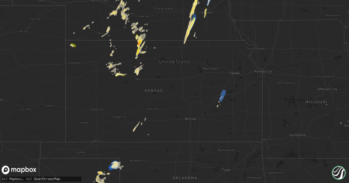
Hail Map in Kansas on September 14, 2025
Get this storm
September 14 map
$229
one time, instant access
Download today. No call, no setup
Keep the $229
Bought the map and want the full workflow? Apply the entire $229 to a subscription within 7 days. None of it is wasted.
Every map, not just this one
This buys you this map. Subscription and you get every map we run, in the markets you choose from a few cities to whole states to nationwide. Plus real-time alerts the moment a storm fires.
Contact data
Name, contact info, occupancy, even credit band for addresses in the footprint. You go from where it hit to who to call.
Become the source they trust
Unlimited branding weather history reports on demand. You already have the documented answer ready for the property owner, and you are the one who showed up with it.
Property data and RoofTrace estimates
Pull up any address you have got, its value and the exact code rules for that jurisdiction, straight from One Click Code. Then RoofTrace estimates the squares, pitch, and roof value, priced the way you price.
Storm reports in Kansas
Kansas
| Date | Description |
|---|---|
| 09/14/20256:45 PM CDT | A social media report of 1 inch hail. |
| 09/14/20255:29 PM CDT | Asos station kemp emporia. |
| 09/14/20255:29 PM CDT | Asos stat |
| 09/14/20254:15 PM CDT | [landspout] photo taken from northeast of el dorado on the kansas turnpike. |
| 09/13/20257:30 PM CDT | Spotter reported hail up to half dollar size with his vehicle suffering several dents. |
| 09/13/20257:27 PM CDT | Trego county em reported quarter sized hail 3 w of wakeeney. |
| 09/13/20257:11 PM CDT | Most hail was pea to dimes... A few were as big as golf ball size. |
All States Impacted by Hail Map on September 14, 2025
Cities Impacted by Hail Map on September 14, 2025
- Mobridge, SD
- Cannon Ball, ND
- Linton, ND
- Daykin, NE
- Gilead, NE
- Hebron, NE
- Ohiowa, NE
- Western, NE
- Tobias, NE
- Alexandria, NE
- Mound City, SD
- Hazelton, ND
- Strasburg, ND
- Fort Yates, ND
- Wakpala, SD
- Glenham, SD
- Eagle Butte, SD
- Pollock, SD
- Mandan, ND
- Livermore, KY
- Centertown, KY
- Hartford, KY
- Saint Francis, KS
- West Point, NE
- Oakland, NE
- Munden, KS
- Hubbell, NE
- Chester, NE
- Belvidere, NE
- Scribner, NE
- Seward, NE
- Curtis, NE
- Milligan, NE
- Friend, NE
- Bismarck, ND
- Staplehurst, NE
- Parks, NE
- Gothenburg, NE
- Hooper, NE
- Dorchester, NE
- Beaver Crossing, NE
- Goehner, NE
- Ulysses, NE
- Cordova, NE
- Rosalie, NE
- Dwight, NE
- Lyons, NE
- Milford, NE
- Utica, NE
- Fairbury, NE
- Exeter, NE
- David City, NE
- Brainard, NE
- Sergeant Bluff, IA
- Homer, NE
- Sioux City, IA
- Dakota City, NE
- South Sioux City, NE
- Hinton, IA
- Wauneta, NE
- Endicott, NE
- Walthill, NE
- Palisade, NE
- Menoken, ND
- Cedar Bluffs, NE
- Farnam, NE
- Moorefield, NE
- Callaway, NE
- Macy, NE
- Linwood, NE
- Bruno, NE
- Haviland, KS
- Ellington, MO
- Baldwin, ND
- Rogers, NE
- Morse Bluff, NE
- North Bend, NE
- Dodge, NE
- Brady, NE
- Ames, NE
- Winnebago, NE
- Sloan, IA
- Salix, IA
- Bee, NE
- Abie, NE
- Schuyler, NE
- Trenton, NE
- Wing, ND
- Snyder, NE
- Martell, NE
- Lincoln, NE
- Broken Bow, NE
- Cozad, NE
- North Platte, NE
- Hayes Center, NE
- Prague, NE
- Denton, NE
- Beemer, NE
- Butte, ND
- Merna, NE
- Willow Island, NE
- McCook, NE
- Bancroft, NE
- Shattuck, OK
- Fargo, OK
- Hedley, TX
- Memphis, TX
- Stockville, NE
- Indianola, NE
- Denhoff, ND
- Voltaire, ND
- Balfour, ND
- Hoxie, KS
- Mount Vernon, IL
- Waltonville, IL
- Bonnie, IL
- Salem, MO
- Wishek, ND
- Zeeland, ND
- Wellington, TX
- Ceresco, NE
- Davey, NE
- Iberia, MO
- Golconda, IL
- Lakeview, TX
- Dell Rapids, SD
- Trent, SD
- Egan, SD
- Beaver Creek, MN
- Hills, MN
- Luverne, MN
- Hardwick, MN
- Jasper, MN
- New Effington, SD
- Sisseton, SD
- Rosholt, SD
- Fairmount, ND
- Hankinson, ND
- Wahpeton, ND
- Mantador, ND
- Mooreton, ND
- Barney, ND
- Wyndmere, ND
- Wilton, ND
- Karlsruhe, ND
- La Vista, NE
- Papillion, NE
- Omaha, NE
- Oberlin, KS
- Clayton, IL
- Hamilton, KS
- Decatur, NE
- Wahoo, NE
- Oconto, NE
- Childress, TX
- Pingree, ND
- Sargent, NE
- Fremont, NE
- Mead, NE
- Colon, NE
- Anselmo, NE
- Dresden, KS
- Jennings, KS
- Danbury, NE
- Butler, IL
- Selden, KS
- Greenville, MO
- Du Bois, IL
- Ashley, IL
- Eureka, KS
- Greenville, IL
- Sorento, IL
- Royalton, IL
- Metropolis, IL
- Napoleon, ND
- Mulkeytown, IL
- Lexington, NE
- Turtle Lake, ND
- Mercer, ND
- Carrington, ND
- Booker, TX
- Lake City, KS
- Litchfield, IL
- Burwell, NE
- Taylor, NE
- Olpe, KS
- Carterville, IL
- Scheller, IL
- Nickerson, NE
- Arlington, NE
- Madison, KS
- Emporia, KS
- Hartford, KS
- Neosho Rapids, KS
- Ithaca, NE
- Dodson, TX
- Johnstown, NE
- Elsmere, NE
- Wood Lake, NE
- Jacksonville, IL
- Alexander, IL
- Follett, TX
- De Soto, IL
- Herman, NE
- Tekamah, NE
- Craig, NE
- Vergennes, IL
- Elwood, NE
- Blair, NE
- Eustis, NE
- Reading, KS
- Admire, KS
- Astoria, SD
- Brandt, SD
- Gary, SD
- New Rockford, ND
- Grace City, ND
- Glenfield, ND
- Mchenry, ND
- Williamsville, MO
- Murphysboro, IL
- Saint Jacob, IL
- Norcatur, KS
- Norton, KS
- Clayton, KS
- Seminole, TX
- Carbondale, IL
- Higgins, TX
- Laverne, OK
- Tamaroa, IL
- Eddyville, NE
- Cathay, ND
- Plainville, KS
- Ellis, KS
- Hays, KS
- Lipscomb, TX
- Smithfield, NE
- Warwick, ND
- Protection, KS
- Springview, NE
- Arapahoe, NE
- Edison, NE
- Bertrand, NE
- Drake, ND
- Sumner, NE
- Morland, KS
- New Baden, IL
- Mullinville, KS
- Fairdealing, MO
- Harviell, MO
- Grandin, MO
- Loomis, NE
- Atlanta, NE
- Quinter, KS
- Doniphan, MO
- Arnett, OK
- Ellsinore, MO
- Pomona, IL
- Canadian, TX
- Moro, IL
- Oxford, NE
- Orleans, NE
- Alma, NE
- Holdrege, NE
- Miami, TX
- Phillipsburg, KS
- Rockwood, IL
- Jacob, IL
- Campbell Hill, IL
- Glade, KS
- Ava, IL
- Gorham, IL
- Collyer, KS
- Penokee, KS
- Harrisburg, IL
- Mason City, NE
- Republican City, NE
- Devils Lake, ND
- Hill City, KS
- Winner, SD
- Van Horn, TX
- Pinckneyville, IL
- Greensburg, KS
- Granville, ND
- Oacoma, SD
- Reliance, SD
- Chamberlain, SD
- Cadiz, KY
- Wilcox, NE
- Benton, IL
- Stockton, KS
- Cutler, IL
- Funk, NE
- Colome, SD
- Agra, KS
- Hildreth, NE
- Naponee, NE
- Sparta, IL
- Coulterville, IL
- Cottage Grove, TN
- Puryear, TN
- Paris, TN
- Wakeeney, KS
- Lower Brule, SD
- Dallas, SD
- Bloomington, NE
- Pocahontas, AR
- Minden, NE
- Odin, IL
- Murray, KY
- Dexter, KY
- Axtell, NE
- Sandoval, IL
- Centralia, IL
- Christopher, IL
- Sesser, IL
- Palmersville, TN
- Upland, NE
- Hampden, ND
- Kensington, KS
- Henry, TN
- Alsen, ND
- Wales, ND
- Grand Chain, IL
- Kirwin, KS
- Gaylord, KS
- Cedar, KS
- Park, KS
- Percy, IL
- Wickliffe, KY
- La Center, KY
- Kevil, KY
- Perryton, TX
- Hannah, ND
- Boaz, KY
- Bardwell, KY
- Lebanon, KS
- Smith Center, KS
- Arlington, KY
- Hickory, KY
- Natoma, KS
- Mayfield, KY
- Fancy Farm, KY
- Clinton, KY
- Marble Hill, MO
- Symsonia, KY
- Benton, KY
- Leopold, MO
- Wingo, KY
- Fulton, KY
- Hickman, KY
- Columbus, KY
- Union City, TN
- South Fulton, TN
- Charleston, MO
- Sikeston, MO
- East Prairie, MO
- Matthews, MO
- Anniston, MO
- Essex, MO
- Centerville, TN
- Nunnelly, TN
- Puxico, MO
- Lowndes, MO
- Wappapello, MO
- Duke, OK
- Mangum, OK


