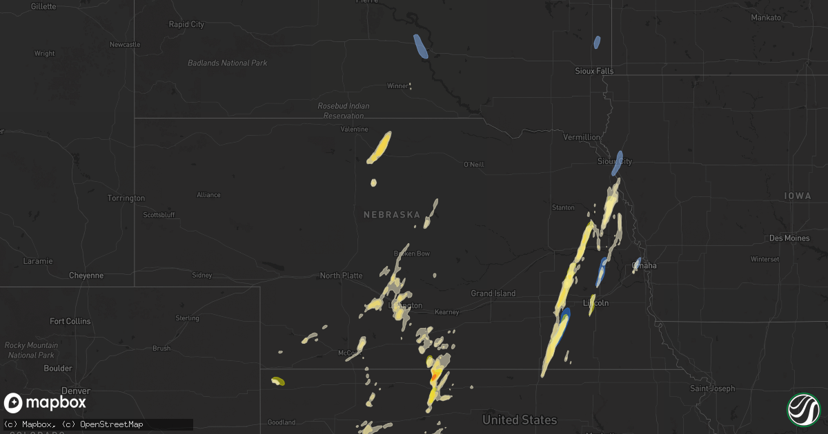
Hail Map in Nebraska on September 14, 2025
Get this storm
September 14 map
$229
one time, instant access
Download today. No call, no setup
Keep the $229
Bought the map and want the full workflow? Apply the entire $229 to a subscription within 7 days. None of it is wasted.
Every map, not just this one
This buys you this map. Subscription and you get every map we run, in the markets you choose from a few cities to whole states to nationwide. Plus real-time alerts the moment a storm fires.
Contact data
Name, contact info, occupancy, even credit band for addresses in the footprint. You go from where it hit to who to call.
Become the source they trust
Unlimited branding weather history reports on demand. You already have the documented answer ready for the property owner, and you are the one who showed up with it.
Property data and RoofTrace estimates
Pull up any address you have got, its value and the exact code rules for that jurisdiction, straight from One Click Code. Then RoofTrace estimates the squares, pitch, and roof value, priced the way you price.
Storm reports in Nebraska
Nebraska
| Date | Description |
|---|---|
| 09/14/20256:57 PM CDT | Photo via facebook. |
| 09/14/20255:00 PM CDT | Former nws employee reported wind gusts 60-65 mph... Bringing down a couple 6-8 inch tree limbs. Time estimated via radar. |
| 09/14/20254:50 PM CDT | Delayed report. Large tree branches snapped; one of which fell on a house. Report and photos shared by broadcast media. Report time based on radar data. |
| 09/14/20254:50 PM CDT | A local report indicates 60 MPH wind near Wahoo |
| 09/14/20254:35 PM CDT | A local report indicates 1.25 inch wind near Lyons |
| 09/14/20254:10 PM CDT | Nickel to quarter-sized hail. |
| 09/14/20254:05 PM CDT | A local report indicates 1.00 inch wind near 1 SSW Snyder |
| 09/14/20254:00 PM CDT | A local report indicates 1.00 inch wind near 4 E Denton |
| 09/14/20253:36 PM CDT | Photos shared via social media of a destroyed outbuilding and a large... Downed tree branch which did damage to the roof of a home. Time estimated based on radar. |
| 09/14/20253:18 PM CDT | Delayed public report of hail measured at 1 inch in diameter. Time estimated via radar. |
| 09/14/20253:12 PM CDT | Tree uprooted. Time estimated from radar. |
| 09/14/20253:10 PM CDT | A local report indicates 1.00 inch wind near 3 NNE Tamora |
| 09/14/20253:06 PM CDT | Social media report of a lot of power poles down near tamora. |
| 09/14/20252:56 PM CDT | A local report indicates 59 MPH wind near 2 W Dorchester |
| 09/14/20252:48 PM CDT | Large branch down on house near friend. Reported via social media. Time estimated from radar. |
| 09/14/20252:36 PM CDT | Trees and power lines down. Power poles snapped. |
| 09/14/20252:16 PM CDT | Brief quarter size hail...also somewhat strong winds but no speed estimation. |
All States Impacted by Hail Map on September 14, 2025
Cities Impacted by Hail Map on September 14, 2025
- Mobridge, SD
- Cannon Ball, ND
- Linton, ND
- Daykin, NE
- Gilead, NE
- Hebron, NE
- Ohiowa, NE
- Western, NE
- Tobias, NE
- Alexandria, NE
- Mound City, SD
- Hazelton, ND
- Strasburg, ND
- Fort Yates, ND
- Wakpala, SD
- Glenham, SD
- Eagle Butte, SD
- Pollock, SD
- Mandan, ND
- Livermore, KY
- Centertown, KY
- Hartford, KY
- Saint Francis, KS
- West Point, NE
- Oakland, NE
- Munden, KS
- Hubbell, NE
- Chester, NE
- Belvidere, NE
- Scribner, NE
- Seward, NE
- Curtis, NE
- Milligan, NE
- Friend, NE
- Bismarck, ND
- Staplehurst, NE
- Parks, NE
- Gothenburg, NE
- Hooper, NE
- Dorchester, NE
- Beaver Crossing, NE
- Goehner, NE
- Ulysses, NE
- Cordova, NE
- Rosalie, NE
- Dwight, NE
- Lyons, NE
- Milford, NE
- Utica, NE
- Fairbury, NE
- Exeter, NE
- David City, NE
- Brainard, NE
- Sergeant Bluff, IA
- Homer, NE
- Sioux City, IA
- Dakota City, NE
- South Sioux City, NE
- Hinton, IA
- Wauneta, NE
- Endicott, NE
- Walthill, NE
- Palisade, NE
- Menoken, ND
- Cedar Bluffs, NE
- Farnam, NE
- Moorefield, NE
- Callaway, NE
- Macy, NE
- Linwood, NE
- Bruno, NE
- Haviland, KS
- Ellington, MO
- Baldwin, ND
- Rogers, NE
- Morse Bluff, NE
- North Bend, NE
- Dodge, NE
- Brady, NE
- Ames, NE
- Winnebago, NE
- Sloan, IA
- Salix, IA
- Bee, NE
- Abie, NE
- Schuyler, NE
- Trenton, NE
- Wing, ND
- Snyder, NE
- Martell, NE
- Lincoln, NE
- Broken Bow, NE
- Cozad, NE
- North Platte, NE
- Hayes Center, NE
- Prague, NE
- Denton, NE
- Beemer, NE
- Butte, ND
- Merna, NE
- Willow Island, NE
- McCook, NE
- Bancroft, NE
- Shattuck, OK
- Fargo, OK
- Hedley, TX
- Memphis, TX
- Stockville, NE
- Indianola, NE
- Denhoff, ND
- Voltaire, ND
- Balfour, ND
- Hoxie, KS
- Mount Vernon, IL
- Waltonville, IL
- Bonnie, IL
- Salem, MO
- Wishek, ND
- Zeeland, ND
- Wellington, TX
- Ceresco, NE
- Davey, NE
- Iberia, MO
- Golconda, IL
- Lakeview, TX
- Dell Rapids, SD
- Trent, SD
- Egan, SD
- Beaver Creek, MN
- Hills, MN
- Luverne, MN
- Hardwick, MN
- Jasper, MN
- New Effington, SD
- Sisseton, SD
- Rosholt, SD
- Fairmount, ND
- Hankinson, ND
- Wahpeton, ND
- Mantador, ND
- Mooreton, ND
- Barney, ND
- Wyndmere, ND
- Wilton, ND
- Karlsruhe, ND
- La Vista, NE
- Papillion, NE
- Omaha, NE
- Oberlin, KS
- Clayton, IL
- Hamilton, KS
- Decatur, NE
- Wahoo, NE
- Oconto, NE
- Childress, TX
- Pingree, ND
- Sargent, NE
- Fremont, NE
- Mead, NE
- Colon, NE
- Anselmo, NE
- Dresden, KS
- Jennings, KS
- Danbury, NE
- Butler, IL
- Selden, KS
- Greenville, MO
- Du Bois, IL
- Ashley, IL
- Eureka, KS
- Greenville, IL
- Sorento, IL
- Royalton, IL
- Metropolis, IL
- Napoleon, ND
- Mulkeytown, IL
- Lexington, NE
- Turtle Lake, ND
- Mercer, ND
- Carrington, ND
- Booker, TX
- Lake City, KS
- Litchfield, IL
- Burwell, NE
- Taylor, NE
- Olpe, KS
- Carterville, IL
- Scheller, IL
- Nickerson, NE
- Arlington, NE
- Madison, KS
- Emporia, KS
- Hartford, KS
- Neosho Rapids, KS
- Ithaca, NE
- Dodson, TX
- Johnstown, NE
- Elsmere, NE
- Wood Lake, NE
- Jacksonville, IL
- Alexander, IL
- Follett, TX
- De Soto, IL
- Herman, NE
- Tekamah, NE
- Craig, NE
- Vergennes, IL
- Elwood, NE
- Blair, NE
- Eustis, NE
- Reading, KS
- Admire, KS
- Astoria, SD
- Brandt, SD
- Gary, SD
- New Rockford, ND
- Grace City, ND
- Glenfield, ND
- Mchenry, ND
- Williamsville, MO
- Murphysboro, IL
- Saint Jacob, IL
- Norcatur, KS
- Norton, KS
- Clayton, KS
- Seminole, TX
- Carbondale, IL
- Higgins, TX
- Laverne, OK
- Tamaroa, IL
- Eddyville, NE
- Cathay, ND
- Plainville, KS
- Ellis, KS
- Hays, KS
- Lipscomb, TX
- Smithfield, NE
- Warwick, ND
- Protection, KS
- Springview, NE
- Arapahoe, NE
- Edison, NE
- Bertrand, NE
- Drake, ND
- Sumner, NE
- Morland, KS
- New Baden, IL
- Mullinville, KS
- Fairdealing, MO
- Harviell, MO
- Grandin, MO
- Loomis, NE
- Atlanta, NE
- Quinter, KS
- Doniphan, MO
- Arnett, OK
- Ellsinore, MO
- Pomona, IL
- Canadian, TX
- Moro, IL
- Oxford, NE
- Orleans, NE
- Alma, NE
- Holdrege, NE
- Miami, TX
- Phillipsburg, KS
- Rockwood, IL
- Jacob, IL
- Campbell Hill, IL
- Glade, KS
- Ava, IL
- Gorham, IL
- Collyer, KS
- Penokee, KS
- Harrisburg, IL
- Mason City, NE
- Republican City, NE
- Devils Lake, ND
- Hill City, KS
- Winner, SD
- Van Horn, TX
- Pinckneyville, IL
- Greensburg, KS
- Granville, ND
- Oacoma, SD
- Reliance, SD
- Chamberlain, SD
- Cadiz, KY
- Wilcox, NE
- Benton, IL
- Stockton, KS
- Cutler, IL
- Funk, NE
- Colome, SD
- Agra, KS
- Hildreth, NE
- Naponee, NE
- Sparta, IL
- Coulterville, IL
- Cottage Grove, TN
- Puryear, TN
- Paris, TN
- Wakeeney, KS
- Lower Brule, SD
- Dallas, SD
- Bloomington, NE
- Pocahontas, AR
- Minden, NE
- Odin, IL
- Murray, KY
- Dexter, KY
- Axtell, NE
- Sandoval, IL
- Centralia, IL
- Christopher, IL
- Sesser, IL
- Palmersville, TN
- Upland, NE
- Hampden, ND
- Kensington, KS
- Henry, TN
- Alsen, ND
- Wales, ND
- Grand Chain, IL
- Kirwin, KS
- Gaylord, KS
- Cedar, KS
- Park, KS
- Percy, IL
- Wickliffe, KY
- La Center, KY
- Kevil, KY
- Perryton, TX
- Hannah, ND
- Boaz, KY
- Bardwell, KY
- Lebanon, KS
- Smith Center, KS
- Arlington, KY
- Hickory, KY
- Natoma, KS
- Mayfield, KY
- Fancy Farm, KY
- Clinton, KY
- Marble Hill, MO
- Symsonia, KY
- Benton, KY
- Leopold, MO
- Wingo, KY
- Fulton, KY
- Hickman, KY
- Columbus, KY
- Union City, TN
- South Fulton, TN
- Charleston, MO
- Sikeston, MO
- East Prairie, MO
- Matthews, MO
- Anniston, MO
- Essex, MO
- Centerville, TN
- Nunnelly, TN
- Puxico, MO
- Lowndes, MO
- Wappapello, MO
- Duke, OK
- Mangum, OK


