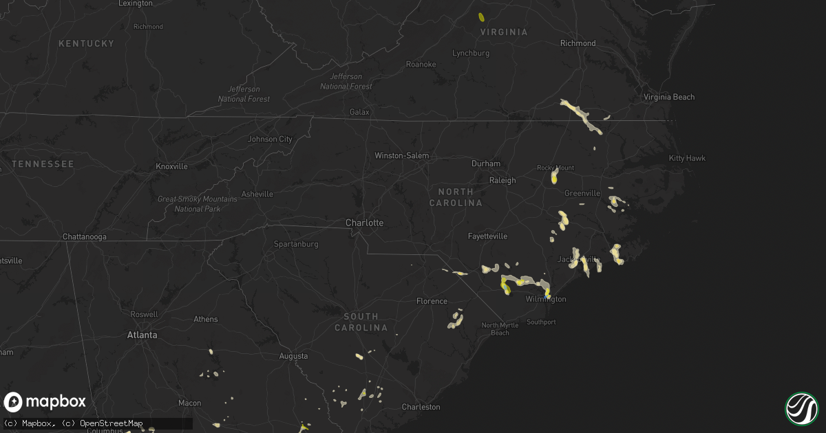
Hail Map in North Carolina on September 9, 2019
Get this storm
September 9 map
$229
one time, instant access
Download today. No call, no setup
Keep the $229
Bought the map and want the full workflow? Apply the entire $229 to a subscription within 7 days. None of it is wasted.
Every map, not just this one
This buys you this map. Subscription and you get every map we run, in the markets you choose from a few cities to whole states to nationwide. Plus real-time alerts the moment a storm fires.
Contact data
Name, contact info, occupancy, even credit band for addresses in the footprint. You go from where it hit to who to call.
Become the source they trust
Unlimited branding weather history reports on demand. You already have the documented answer ready for the property owner, and you are the one who showed up with it.
Property data and RoofTrace estimates
Pull up any address you have got, its value and the exact code rules for that jurisdiction, straight from One Click Code. Then RoofTrace estimates the squares, pitch, and roof value, priced the way you price.
Storm reports in North Carolina
North Carolina
| Date | Description |
|---|---|
| 09/09/20195:57 PM CDT | A local report indicates 1.00 inch wind near KELLY |
| 09/09/20195:42 PM CDT | Quarter sized hail reported on pender avenue. |
| 09/09/20195:35 PM CDT | Minor roof damage to wilson center. |
| 09/09/20195:32 PM CDT | Report of strong winds with debris in the air at patsy lane and gordon road. Dime sized hail also reported. |
| 09/09/20195:28 PM CDT | Report of strong winds with debris in the air at patsy lane and gordon road. Dime sized hail also reported. |
| 09/09/20195:12 PM CDT | Damage to scotts hill market on hwy 17. Time estimated by radar. |
| 09/09/20193:50 PM CDT | A couple of trees down causing power outages. |
| 09/09/20193:40 PM CDT | Pea to quarter size hail. |
| 09/09/20195:11 AM CDT | At 1011 AM EDT, a severe thunderstorm was located over Claresville, or 7 miles southeast of Emporia, moving southeast at 25 mph. HAZARD...60 mph wind gusts and quarter size hail. SOURCE...Radar indicated. IMPACT...Minor damage to vehicles is possible. Expect wind damage to trees and powerlines. This severe thunderstorm will be near, Boykins around 1040 AM EDT. Conway around 1050 AM EDT. Murfreesboro, Chowan University and Como around 1100 AM EDT.Other locations impacted by this severe thunderstorm includeMilwaukee, Pendleton, Menola, Mapleton, Bryants Corner, Union,Riddicksville, Sunbeam, Saint John and Severn. |
| 09/09/20194:46 AM CDT | At 946 PM EDT, a severe thunderstorm was located over Clio, or 8 miles east of Bennettsville, moving west at 15 mph. HAZARD...60 mph wind gusts and quarter size hail. SOURCE...Radar indicated. IMPACT...Minor hail damage to vehicles is possible. Expect wind damage to trees and power lines. Locations impacted include... Bennettsville, Mccoll, Clio, Blenheim and Tatum. |
| 09/09/20194:34 AM CDT | At 934 AM EDT, a severe thunderstorm was located over Emporia, moving southeast at 20 mph. HAZARD...60 mph wind gusts and quarter size hail. SOURCE...Radar indicated. IMPACT...Minor damage to vehicles is possible. Expect wind damage to trees and powerlines. This severe thunderstorm will be near, Green Plain around 945 AM EDT. Claresville around 955 AM EDT.Other locations impacted by this severe thunderstorm include AdamsGrove, Grizzard, Lanes Corner, Bryants Corner, Emporia Reservoir,Mason, Durand, Branchville, Drewryville and Shiloh. |
| 09/09/20194:25 AM CDT | At 925 PM EDT, a severe thunderstorm was located near Raemon, or 10 miles north of Dillon, moving southwest at 20 mph. HAZARD...60 mph wind gusts and quarter size hail. SOURCE...Radar indicated. IMPACT...Minor hail damage to vehicles is possible. Expect wind damage to trees and power lines. Locations impacted include... Rowland, Clio, Raemon, Purvis, Dunbar, Minturn and Little Rock. |
| 09/09/20193:25 AM CDT | At 824 PM EDT, a severe thunderstorm was located near Elm City, or near Rocky Mount, moving south at 20 mph. HAZARD...60 mph wind gusts and quarter size hail. SOURCE...Radar indicated. IMPACT...Hail damage to vehicles is expected. Expect wind damage to roofs, siding, and trees. Locations impacted include... Wilson, Elm City, Sharpsburg, Pinetops, Stantonsburg, Black Creek, Macclesfield, Saratoga, Tar River Reservoir and Willbanks. |
| 09/09/20193:19 AM CDT | At 818 PM EDT, a severe thunderstorm was located near Elkton, or near Whiteville, moving west at 20 mph. HAZARD...60 mph wind gusts and quarter size hail. SOURCE...Radar indicated. IMPACT...Minor hail damage to vehicles is possible. Expect wind damage to trees and power lines. Locations impacted include... Whiteville, Chadbourn, Boardman, Hallsboro, Redbug, Elkton, Emerson, Council, Southeastern Community College, Clarendon, Evergreen, Brunswick, Clarkton and Columbus Regional Healthcare System. |
| 09/09/20191:52 AM CDT | At 652 PM EDT, a severe thunderstorm was located over Kelly, or 17 miles southeast of Elizabethtown, moving west at 10 mph. HAZARD...60 mph wind gusts and quarter size hail. SOURCE...Radar indicated. IMPACT...Minor hail damage to vehicles is possible. Expect wind damage to trees and power lines. Locations impacted include... Rowan, Carvers, Lisbon, Lagoon, Emerson, Council, Kelly and White Lake. |
| 09/09/20191:19 AM CDT | At 619 PM EDT, a severe thunderstorm was located over Wilmington International Airport, or near Wilmington, moving south at 15 mph. HAZARD...60 mph wind gusts and quarter size hail. SOURCE...Trained weather spotters. IMPACT...Minor hail damage to vehicles is possible. Expect wind damage to trees and power lines. Locations impacted include... Wilmington, Leland, Wrightsville Beach, South Masonboro Island, North Masonboro Island, Figure Eight Island, Hightsville, Cape Fear Community College North Campus, Wilmington International Airport, Myrtle Grove, Murrayville, Masonboro, Castle Hayne, Ogden, Mayfaire, Wrightsboro, Silver Lake, Windemere, Bayshore and Porters Neck. |
| 09/09/201912:34 AM CDT | At 533 PM EDT, a severe thunderstorm was located over Rocky Point, or 9 miles south of Burgaw, moving southeast at 20 mph. HAZARD...60 mph wind gusts and penny size hail. SOURCE...Radar indicated. IMPACT...Expect wind damage to trees and power lines. Locations impacted include... Wilmington, Burgaw, Wrightsville Beach, Surf City, Figure Eight Island, Hampstead, Topsail Beach, Maple Hill, Long Creek, Cape Fear Community College North Campus, Ashton, Rocky Point, Murrayville, Castle Hayne, Scotts Hill, Ogden, Woodside, White Stocking, Mayfaire and Montague. |
| 09/09/201912:18 AM CDT | At 517 PM EDT, a severe thunderstorm was located over Verona, or over New River Station, moving southeast at 10 mph. HAZARD...60 mph wind gusts and quarter size hail. SOURCE...Radar indicated. IMPACT...Hail damage to vehicles is expected. Expect wind damage to roofs, siding, and trees. Locations impacted include... Jacksonville, North Topsail Beach, New River Station, Camp Lejeune Center, Folkstone, Verona, Dixon, Onslow Beach, Sneads Ferry, Sea View Pier, Holly Ridge and Haws Run. |
| 09/08/201911:32 PM CDT | At 432 PM EDT, a severe thunderstorm was located over Murfreesboro, moving southeast at 15 mph. HAZARD...60 mph wind gusts and quarter size hail. SOURCE...Radar indicated. IMPACT...Minor damage to vehicles is possible. Expect wind damage to trees and powerlines. This severe thunderstorm will be near, Ahoskie, Winton and Cofield around 500 PM EDT.Other locations impacted by this severe thunderstorm include Tunis,Eure, Oak Villa, Bartonsville, Chowan Beach, Rays Beach, Mapleton,Barretts Crossroad, Brantleys Grove and Union. |
| 09/08/20197:20 PM CDT | Several large trees down |
All States Impacted by Hail Map on September 9, 2019
Cities Impacted by Hail Map on September 9, 2019
- York, NE
- Letohatchee, AL
- Fort Deposit, AL
- Humboldt, NE
- Dawson, NE
- Greenville, MS
- Lake Village, AR
- Newton, TX
- Winona, KS
- New Raymer, CO
- Hill City, KS
- Lyons, GA
- Emerald Isle, NC
- Johnsonville, SC
- Little Rock, SC
- Hamer, SC
- Fairmont, NC
- Rowland, NC
- Eaton, CO
- Hollandale, MS
- Bennington, NE
- Kennard, NE
- Valley, NE
- Lumberton, NC
- Cedar Falls, IA
- Hudson, IA
- Waterloo, IA
- Jacksonville, NC
- Baton Rouge, LA
- Saint Gabriel, LA
- Prairieville, LA
- Castle Hayne, NC
- Wilmington, NC
- Vidalia, GA
- Monticello, MS
- Jayess, MS
- Petal, MS
- Hattiesburg, MS
- Cordova, SC
- Orangeburg, SC
- Mullins, SC
- Marion, SC
- Woodville, MS
- Hoxie, KS
- Cusseta, GA
- Monument, KS
- Grinnell, KS
- Wallace, KS
- Oakley, KS
- Holly, CO
- Granada, CO
- La Salle, CO
- Leakesville, MS
- Kinder, LA
- Dyersville, IA
- Earlville, IA
- Worthington, IA
- Farley, IA
- Hopkinton, IA
- Hayneville, AL
- Buena Vista, GA
- Grundy Center, IA
- Glenwood, GA
- Monona, IA
- Mead, NE
- Fremont, NE
- Arlington, NE
- Yutan, NE
- Wahoo, NE
- Lineville, AL
- Ashland, AL
- Talladega, AL
- Gresham, SC
- Galivants Ferry, SC
- Morehead City, NC
- Atlantic Beach, NC
- Kersey, CO
- Fort Morgan, CO
- Orchard, CO
- Weldona, CO
- Briggsdale, CO
- Joaquin, TX
- Lingle, WY
- Mchenry, IL
- Roxie, MS
- Hawk Springs, WY
- Whiteville, NC
- Hallsboro, NC
- Clarkton, NC
- Reynolds, GA
- Ideal, GA
- Ashland, NE
- Kinston, NC
- Ulysses, NE
- Jesup, IA
- Fairfax, SC
- Newport, NC
- Mechanicsville, IA
- Lisbon, IA
- Soso, MS
- Havelock, NC
- Rocky Mount, NC
- Elm City, NC
- Perry, IA
- Olla, LA
- Merino, CO
- Pine Bluff, AR
- Dadeville, AL
- Clanton, AL
- Luray, SC
- Estill, SC
- Brunson, SC
- Hampton, SC
- Pineview, GA
- Hawkinsville, GA
- Moselle, MS
- Ellisville, MS
- Greeley, CO
- Gill, CO
- Montrose, GA
- Taylorsville, MS
- Collins, MS
- Mount Olive, MS
- Luverne, AL
- Rutledge, AL
- Greenville, AL
- Ovett, MS
- Richton, MS
- Bogue Chitto, MS
- Ailey, GA
- Mount Vernon, GA
- Strawberry Point, IA
- Evergreen, AL
- Brewton, AL
- Columbia, MS
- Bassfield, MS
- Carson, MS
- Call, TX
- Buckhead, GA
- Scribner, NE
- Elkhorn, NE
- Dermott, AR
- Rayville, LA
- Lake Waccamaw, NC
- Richland, GA
- Castleberry, AL
- Fleming, CO
- Burgaw, NC
- Rolling Fork, MS
- Yazoo City, MS
- Holly Bluff, MS
- Silver Creek, MS
- Newhebron, MS
- Emporia, VA
- Branchville, VA
- Freeman, VA
- Margarettsville, NC
- Laurel, MS
- Waynesboro, MS
- Shubuta, MS
- Hubert, NC
- Sterling, CO
- Iliff, CO
- Stoneham, CO
- Snyder, CO
- Jena, LA
- Trout, LA
- Torrington, WY
- Yoder, WY
- Veteran, WY
- Omaha, GA
- Pittsview, AL
- Lumpkin, GA
- Fort Mitchell, AL
- Hermanville, MS
- Maplesville, AL
- Franklin, VA
- Union Church, MS
- Barneveld, WI
- Blue Mounds, WI
- Dublin, GA
- Camp Lejeune, NC
- Rupert, GA
- Bastrop, LA
- Woodstock, IL
- Platteville, CO
- Tarrytown, GA
- Sumrall, MS
- Natchez, MS
- Crosby, MS
- Minter, AL
- Rhine, GA
- Milan, GA
- Rochelle, GA
- Abbeville, GA
- Wilson, NC
- Morland, KS
- Cascade, IA
- Bernard, IA
- Anamosa, IA
- Rexford, KS
- Mauk, GA
- Cobbtown, GA
- Traer, IA
- Dysart, IA
- Statesboro, GA
- Verbena, AL
- Pinetown, NC
- Hamburg, AR
- Crossett, AR
- Pollock, LA
- Albany, GA
- Rupert, ID
- Pilger, NE
- Pink Hill, NC
- Kenansville, NC
- Beulaville, NC
- Billingsley, AL
- Madison, MS
- Canton, MS
- Shirley, AR
- Alamo, GA
- Murfreesboro, NC
- Winnfield, LA
- Kelly, LA
- Brainard, NE
- Staplehurst, NE
- Gresham, NE
- David City, NE
- Dwight, NE
- Bladenboro, NC
- Browns Valley, MN
- Sisseton, SD
- Monticello, IA
- Center Junction, IA
- Avoca, WI
- Tar Heel, NC
- Elizabethtown, NC
- Bath, NC
- Washington, NC
- Conrad, IA
- Union, IA
- New Providence, IA
- Eldora, IA
- Tifton, GA
- Preston, GA
- Council, NC
- Riegelwood, NC
- Fort Benning, GA
- Glen Haven, WI
- Portland, AR
- Thomasville, AL
- Kelly, NC
- Kelford, NC
- Lewiston Woodville, NC
- De Witt, IA
- Midway Park, NC
- Tarawa Terrace, NC
- Albertson, NC
- Sylvester, GA
- Baxley, GA
- Stratford, SD
- Janesville, IA
- Register, GA
- Deep Run, NC
- Snow Hill, NC
- La Grange, NC
- Pembroke, GA
- Fort Myers, FL
- Lehigh Acres, FL
- Waterloo, NE
- Deatsville, AL
- Marbury, AL
- Geismar, LA
- Madison, NE
- Ashburn, GA
- Dodson, LA
- Sikes, LA
- Harrells, NC
- Eastman, GA
- Penokee, KS
- Wilmot, AR
- Early Branch, SC
- Millen, GA
- Rentz, GA
- Waverly, IA
- Libertyville, IL
- Vernon Hills, IL
- Mundelein, IL
- Ithaca, NE
- Mount Olive, NC
- Pioneer, LA
- Reinbeck, IA
- Omaha, NE
- Danville, GA
- Hazlehurst, MS
- Georgetown, MS
- Jesup, GA
- Dumont, MN
- Sontag, MS
- Cheyenne, WY
- McRae Helena, GA
- Hazelton, ID
- Jerome, ID
- Savannah, GA
- Bloomingdale, GA
- Alma, GA
- Gunnison, MS
- Utica, MS
- Ryan, IA
- Manchester, IA
- Stanton, NE
- Meadville, MS
- Fitzgerald, GA
- Ahoskie, NC
- Pattison, MS
- Fayette, MS
- Lorman, MS
- Americus, GA
- Plains, GA
- Eatonton, GA
- La Porte City, IA
- Brenham, TX
- Alva, FL
- Clio, SC
- Albion, IA
- Cobb, GA
- Manning, SC
- Red Level, AL
- Andalusia, AL
- Butler, GA
- La Motte, IA
- Zwingle, IA
- Bellevue, IA
- Ruffin, SC
- Jackson, AL
- Grosse Tete, LA
- Plaquemine, LA
- Farmersburg, IA
- Andrews, TX
- Ralls, TX
- Ludowici, GA
- Eudora, AR
- Seale, AL
- Grady, AL
- Aurora, NC
- Edward, NC
- Blounts Creek, NC
- Allendale, SC
- Chula, GA
- Merryville, LA
- Shullsburg, WI
- Brookeland, TX
- Shell Rock, IA
- New Hartford, IA
- Livingston, LA
- Groton, SD
- Andover, SD
- Pierpont, SD
- Bentonia, MS
- De Berry, TX
- Carthage, TX
- Grayslake, IL
- Round Lake, IL
- Wauconda, IL
- Ingleside, IL
- Ellaville, GA
- Soperton, GA
- Brandon, IA
- Pinola, MS
- Currie, NC
- Beaufort, NC
- Shelby, NE
- Hemphill, TX
- Cameron, SC
- Mize, MS
- Verona, WI
- Round O, SC
- Utica, NE
- Rising City, NE
- Sandersville, GA
- Tennille, GA
- Flora, MS
- Arabi, GA
- Toomsboro, GA
- Clarence, IA
- Lowden, IA
- Crystal Lake, IL
- Fox Lake, IL
- Cary, IL
- Island Lake, IL
- Port Allen, LA
- Hatchechubbee, AL
- Brookhaven, MS
- Gurnee, IL
- Wadsworth, IL
- Wray, GA
- Columbus, NE
- Wisner, NE
- Box Springs, GA
- Brooklet, GA
- Union Springs, AL
- Highland Home, AL
- Greensboro, GA
- Gilbertville, IA
- Dike, IA
- Holland, IA
- Parkersburg, IA
- Buckingham, IA
- Dawson, IA
- Linden, IA
- Oak Vale, MS
- Winthrop, IA
- Quasqueton, IA
- Rowley, IA
- Belhaven, NC
- Jay Em, WY
- Pendleton, NC
- Conway, NC
- Clutier, IA
- Waco, NE
- Camden, AL
- Stella, NC
- Swansboro, NC
- Vinton, IA
- Mount Auburn, IA
- Coggon, IA
- Walker, IA
- Garrison, IA
- Smoaks, SC
- Bon Wier, TX
- Grove Hill, AL
- Oglethorpe, GA
- Quitman, LA
- Harpers Ferry, IA
- Sparta, GA
- Masonville, IA
- Hazleton, IA
- Independence, IA
- Metter, GA
- Mount Horeb, WI
- Peru, NE
- Brownville, NE
- Louin, MS
- Oakfield, GA
- Ayden, NC
- Delmar, IA
- Lost Nation, IA
- Wheatland, IA
- Selden, KS
- Florien, LA
- Many, LA
- Chesterfield, SC
- Rocky Point, NC
- Clinton, AR
- Richlands, NC
- Guttenberg, IA
- West Branch, IA
- Tipton, IA
- Iowa City, IA
- Baker, LA
- Walterboro, SC
- Hooper, NE
- Herman, NE
- Prattville, AL
- Drewryville, VA
- Boykins, VA
- Clio, AL
- Louisville, AL
- Saint Stephens, AL
- Harrisonburg, LA
- Grayson, LA
- Warwick, GA
- Leesburg, GA
- Colo, IA
- State Center, IA
- Richards, TX
- Wyoming, IA
- Oxford Junction, IA
- Ivanhoe, NC
- Atkinson, NC
- Port Wentworth, GA
- Pooler, GA
- Seminary, MS
- Plantersville, AL
- Islandton, SC
- Franklinton, LA
- Lamont, IA
- Dexter, IA
- Andersonville, GA
- Prentiss, MS
- Marshalltown, IA
- Beaman, IA
- Sylvania, GA
- Satartia, MS
- Ogden, IA
- Donnelly, MN
- Mansfield, LA
- Logansport, LA
- Twin Falls, ID
- Hansen, ID
- Filer, ID
- Paul, ID
- Eden, ID
- Kimberly, ID
- Earlham, IA
- Van Meter, IA
- Adair, IA
- Waukee, IA
- Bridgewater, IA
- Fontanelle, IA
- Casey, IA
- De Soto, IA
- Greenfield, IA
- Dallas Center, IA
- Adel, IA
- Anita, IA
- Clive, IA
- Stuart, IA
- Menlo, IA
- Urbandale, IA
- Massena, IA
- Minburn, IA
- Redfield, IA
- Ames, IA
- McCallsburg, IA
- Garden City, IA
- Boone, IA
- Gilbert, IA
- Radcliffe, IA
- Hubbard, IA
- Nevada, IA
- Story City, IA
- Roland, IA
- Clemons, IA
- Saint Anthony, IA
- Zearing, IA
- Liscomb, IA
- Morrison, IA
- Whitten, IA
- Collins, IA
- Maxwell, IA
- Corning, IA
- Aplington, IA
- Steamboat Rock, IA
- Wellsburg, IA
- Stanwood, IA
- Maquoketa, IA
- Spragueville, IA
- Des Moines, IA
- Norwalk, IA
- Tyro, VA
- Lyndhurst, VA
- Roseland, VA
- Raleigh, MS
- Morton, MS
- Brandon, MS
- Cross Plains, WI
- Middleton, WI
- Madison, WI
- Walworth, WI
- Williams Bay, WI
- Fontana, WI
- Hayti, SD
- Bristol, SD


