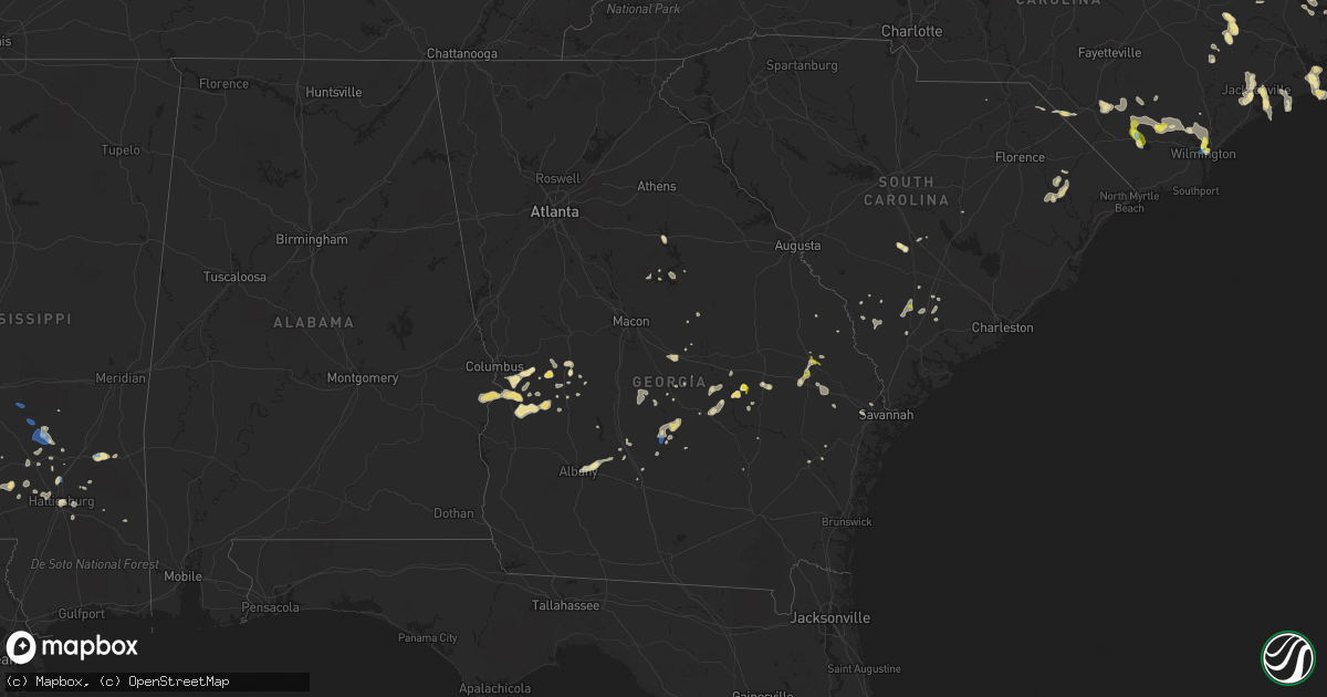
Hail Map in Georgia on September 9, 2019
Get this storm
September 9 map
$229
one time, instant access
Download today. No call, no setup
Keep the $229
Bought the map and want the full workflow? Apply the entire $229 to a subscription within 7 days. None of it is wasted.
Every map, not just this one
This buys you this map. Subscription and you get every map we run, in the markets you choose from a few cities to whole states to nationwide. Plus real-time alerts the moment a storm fires.
Contact data
Name, contact info, occupancy, even credit band for addresses in the footprint. You go from where it hit to who to call.
Become the source they trust
Unlimited branding weather history reports on demand. You already have the documented answer ready for the property owner, and you are the one who showed up with it.
Property data and RoofTrace estimates
Pull up any address you have got, its value and the exact code rules for that jurisdiction, straight from One Click Code. Then RoofTrace estimates the squares, pitch, and roof value, priced the way you price.
Storm reports in Georgia
Georgia
| Date | Description |
|---|---|
| 09/09/20195:00 PM CDT | Tree down. |
| 09/09/20192:49 PM CDT | Tree down near the intersection of louvale rd and jamestown rd. |
| 09/09/20192:46 PM CDT | A tree was reported down on 215 south near sibbie road. |
| 09/09/20192:40 PM CDT | A 911 call center reported a tree down at the 700 block of bowen lane. |
| 09/09/20192:38 PM CDT | Log truck toppled over by wind on mistletoe road... Near american legion road. |
| 09/09/20192:30 PM CDT | A 911 call center reported a tree down at old groveland rd and nevills groveland rd. |
| 09/09/20192:05 PM CDT | A tree was reported down on high 280 near sand grove baptist church. |
| 09/09/20191:47 PM CDT | Tree reported down on lotts creek rd. |
| 09/09/20191:40 PM CDT | Report of quarter-sized hail at the intersection of hunters way and lakeview rd. |
| 09/09/20191:39 PM CDT | A member of the public reported approximately quarter-sized hail near the intersection of lakeview and maria sorrell road. |
| 09/09/20191:35 PM CDT | A member of the public reported nickel to quarter-sized hail on akins pond road in the town of hopeulikit. |
| 09/09/20191:30 PM CDT | A member of the public reported quarter-sized hail near the hwy 80/25 split. |
| 09/09/20191:30 PM CDT | A report of a tree down on the side of the road near the hwy 80/25 split. |
| 09/09/20191:28 PM CDT | Tree reported down on the road on old glenwood rd. |
| 09/09/20191:25 PM CDT | A tree was reported down on orphans cemetary road. |
| 09/09/20191:25 PM CDT | Quarter size hail on middle ground road. |
| 09/09/20191:20 PM CDT | Public reported quarter to ping pong ball sized hail at the intersection of hamilton rd and thompson pond rd. |
| 09/09/201912:55 AM CDT | At 554 PM EDT, a severe thunderstorm was located near Marine Corps Logistics Base, or 8 miles east of Albany, moving southwest at 10 mph. HAZARD...60 mph wind gusts and nickel size hail. SOURCE...Radar indicated. IMPACT...Expect damage to roofs, siding, and trees. Locations impacted include... Albany, Turner City, East Albany, Marine Corps Logistics Base, Stocks, Pecan City and South Albany. |
| 09/08/201910:47 PM CDT | At 346 PM EDT, a severe thunderstorm was located over Browning, or near Abbeville, moving southwest at 10 mph. HAZARD...60 mph wind gusts and quarter size hail. SOURCE...Radar indicated. IMPACT...Hail damage to vehicles is expected. Expect wind damage to roofs, siding, and trees. Locations impacted include... Abbeville, Rhine, Browning and Antioch Church. |
| 09/08/201910:21 PM CDT | At 320 PM EDT, a severe thunderstorm was located near Eelbeck/West Fort Benning, or 8 miles northeast of Cusseta, moving southwest at 10 mph. HAZARD...60 mph wind gusts and quarter size hail. SOURCE...Radar indicated. IMPACT...Hail damage to vehicles is expected. Expect wind damage to roofs, siding, and trees. Locations impacted include... Cusseta, Brantley, Christopher and Eelbeck/West Fort Benning. |
| 09/08/201910:17 PM CDT | At 316 PM EDT, a severe thunderstorm was located near Richland, or near Preston, and is nearly stationary. HAZARD...60 mph wind gusts and nickel size hail. SOURCE...Radar indicated. IMPACT...Expect damage to roofs, siding, and trees. Locations impacted include... Lumpkin, Richland, Seminole and Brooklyn. |
| 09/08/201910:10 PM CDT | At 310 PM CDT, a severe thunderstorm was located 8 miles south of Fort Benning/lawson Army Air Fld, or 15 miles west of Cusseta, moving west at 5 mph. HAZARD...60 mph wind gusts. SOURCE...Radar indicated. IMPACT...Expect damage to roofs, siding, and trees. Locations impacted include... Russell County Sports Complex, Seale, Rutherford, Hatchechubbe, Uchee Creek, Fort Mitchell and Fort Mitchell Activity Center. |
| 09/08/20199:54 PM CDT | At 254 PM EDT, a severe thunderstorm was located over Friendship, or near Preston, moving southwest at 10 mph. HAZARD...60 mph wind gusts and quarter size hail. SOURCE...Radar indicated. IMPACT...Hail damage to vehicles is expected. Expect wind damage to roofs, siding, and trees. Locations impacted include... Preston, Plains, Church Hill, Friendship and Dumas. |
| 09/08/20199:51 PM CDT | At 251 PM EDT, a severe thunderstorm was located over Scotland, or near Alamo, moving southeast at 10 mph. HAZARD...60 mph wind gusts and quarter size hail. SOURCE...Radar indicated. IMPACT...Hail damage to vehicles is expected. Expect wind damage to roofs, siding, and trees. Locations impacted include... Alamo, Scotland, Towns, Little Ocmulgee State Park, Jordan and Spring Hill. |
| 09/08/20199:48 PM CDT | At 248 PM EDT, a severe thunderstorm was located near Westside, moving south at 10 mph. HAZARD...60 mph wind gusts and quarter size hail. SOURCE...Radar indicated. IMPACT...Minor hail damage to vehicles is possible. Expect wind damage to trees and powerlines. Locations impacted include... Statesboro, Metter, Claxton, Westside, Bay, Brooklet, Hagan and Pulaski.This warning includes I-16 between mile markers 101 and 137. |
| 09/08/20199:38 PM CDT | At 238 PM EDT, severe thunderstorms were located along a line extending from Cedar Creel to near Ideal, moving southwest at 10 mph. HAZARD...60 mph wind gusts and quarter size hail. SOURCE...Radar indicated. IMPACT...Hail damage to vehicles is expected. Expect wind damage to roofs, siding, and trees. Locations impacted include... Buena Vista, Ellaville, Ideal, Putnam, Brantley, Murrays Crossroads, Rupert, Garden Valley, Draneville, Zellobee, Tazewell, Doyle and Walls Crossing. |
| 09/08/20199:23 PM CDT | At 223 PM EDT, a severe thunderstorm was located over Glenwood, or near Alamo, moving southeast at 10 mph. HAZARD...60 mph wind gusts and quarter size hail. SOURCE...Radar indicated. IMPACT...Hail damage to vehicles is expected. Expect wind damage to roofs, siding, and trees. Locations impacted include... Alamo, Mount Vernon, Glenwood and Ailey. |
| 09/08/20199:15 PM CDT | At 215 PM EDT, a severe thunderstorm was located near Cedar Grove, or 9 miles north of Alamo, moving west at 10 mph. HAZARD...60 mph wind gusts and quarter size hail. SOURCE...Radar indicated. IMPACT...Hail damage to vehicles is expected. Expect wind damage to roofs, siding, and trees. Locations impacted include... Lowery and Cedar Grove. |
| 09/08/20199:10 PM CDT | At 210 PM EDT, a severe thunderstorm was located over Middleground, moving east at 5 mph. HAZARD...60 mph wind gusts and penny size hail. SOURCE...Radar indicated. IMPACT...Expect damage to trees and powerlines. Locations impacted include... Statesboro, Sylvania, Middleground, Newington, Oliver, Rocky Ford, Altman and Georgia Southern. |
All States Impacted by Hail Map on September 9, 2019
Cities Impacted by Hail Map on September 9, 2019
- York, NE
- Letohatchee, AL
- Fort Deposit, AL
- Humboldt, NE
- Dawson, NE
- Greenville, MS
- Lake Village, AR
- Newton, TX
- Winona, KS
- New Raymer, CO
- Hill City, KS
- Lyons, GA
- Emerald Isle, NC
- Johnsonville, SC
- Little Rock, SC
- Hamer, SC
- Fairmont, NC
- Rowland, NC
- Eaton, CO
- Hollandale, MS
- Bennington, NE
- Kennard, NE
- Valley, NE
- Lumberton, NC
- Cedar Falls, IA
- Hudson, IA
- Waterloo, IA
- Jacksonville, NC
- Baton Rouge, LA
- Saint Gabriel, LA
- Prairieville, LA
- Castle Hayne, NC
- Wilmington, NC
- Vidalia, GA
- Monticello, MS
- Jayess, MS
- Petal, MS
- Hattiesburg, MS
- Cordova, SC
- Orangeburg, SC
- Mullins, SC
- Marion, SC
- Woodville, MS
- Hoxie, KS
- Cusseta, GA
- Monument, KS
- Grinnell, KS
- Wallace, KS
- Oakley, KS
- Holly, CO
- Granada, CO
- La Salle, CO
- Leakesville, MS
- Kinder, LA
- Dyersville, IA
- Earlville, IA
- Worthington, IA
- Farley, IA
- Hopkinton, IA
- Hayneville, AL
- Buena Vista, GA
- Grundy Center, IA
- Glenwood, GA
- Monona, IA
- Mead, NE
- Fremont, NE
- Arlington, NE
- Yutan, NE
- Wahoo, NE
- Lineville, AL
- Ashland, AL
- Talladega, AL
- Gresham, SC
- Galivants Ferry, SC
- Morehead City, NC
- Atlantic Beach, NC
- Kersey, CO
- Fort Morgan, CO
- Orchard, CO
- Weldona, CO
- Briggsdale, CO
- Joaquin, TX
- Lingle, WY
- Mchenry, IL
- Roxie, MS
- Hawk Springs, WY
- Whiteville, NC
- Hallsboro, NC
- Clarkton, NC
- Reynolds, GA
- Ideal, GA
- Ashland, NE
- Kinston, NC
- Ulysses, NE
- Jesup, IA
- Fairfax, SC
- Newport, NC
- Mechanicsville, IA
- Lisbon, IA
- Soso, MS
- Havelock, NC
- Rocky Mount, NC
- Elm City, NC
- Perry, IA
- Olla, LA
- Merino, CO
- Pine Bluff, AR
- Dadeville, AL
- Clanton, AL
- Luray, SC
- Estill, SC
- Brunson, SC
- Hampton, SC
- Pineview, GA
- Hawkinsville, GA
- Moselle, MS
- Ellisville, MS
- Greeley, CO
- Gill, CO
- Montrose, GA
- Taylorsville, MS
- Collins, MS
- Mount Olive, MS
- Luverne, AL
- Rutledge, AL
- Greenville, AL
- Ovett, MS
- Richton, MS
- Bogue Chitto, MS
- Ailey, GA
- Mount Vernon, GA
- Strawberry Point, IA
- Evergreen, AL
- Brewton, AL
- Columbia, MS
- Bassfield, MS
- Carson, MS
- Call, TX
- Buckhead, GA
- Scribner, NE
- Elkhorn, NE
- Dermott, AR
- Rayville, LA
- Lake Waccamaw, NC
- Richland, GA
- Castleberry, AL
- Fleming, CO
- Burgaw, NC
- Rolling Fork, MS
- Yazoo City, MS
- Holly Bluff, MS
- Silver Creek, MS
- Newhebron, MS
- Emporia, VA
- Branchville, VA
- Freeman, VA
- Margarettsville, NC
- Laurel, MS
- Waynesboro, MS
- Shubuta, MS
- Hubert, NC
- Sterling, CO
- Iliff, CO
- Stoneham, CO
- Snyder, CO
- Jena, LA
- Trout, LA
- Torrington, WY
- Yoder, WY
- Veteran, WY
- Omaha, GA
- Pittsview, AL
- Lumpkin, GA
- Fort Mitchell, AL
- Hermanville, MS
- Maplesville, AL
- Franklin, VA
- Union Church, MS
- Barneveld, WI
- Blue Mounds, WI
- Dublin, GA
- Camp Lejeune, NC
- Rupert, GA
- Bastrop, LA
- Woodstock, IL
- Platteville, CO
- Tarrytown, GA
- Sumrall, MS
- Natchez, MS
- Crosby, MS
- Minter, AL
- Rhine, GA
- Milan, GA
- Rochelle, GA
- Abbeville, GA
- Wilson, NC
- Morland, KS
- Cascade, IA
- Bernard, IA
- Anamosa, IA
- Rexford, KS
- Mauk, GA
- Cobbtown, GA
- Traer, IA
- Dysart, IA
- Statesboro, GA
- Verbena, AL
- Pinetown, NC
- Hamburg, AR
- Crossett, AR
- Pollock, LA
- Albany, GA
- Rupert, ID
- Pilger, NE
- Pink Hill, NC
- Kenansville, NC
- Beulaville, NC
- Billingsley, AL
- Madison, MS
- Canton, MS
- Shirley, AR
- Alamo, GA
- Murfreesboro, NC
- Winnfield, LA
- Kelly, LA
- Brainard, NE
- Staplehurst, NE
- Gresham, NE
- David City, NE
- Dwight, NE
- Bladenboro, NC
- Browns Valley, MN
- Sisseton, SD
- Monticello, IA
- Center Junction, IA
- Avoca, WI
- Tar Heel, NC
- Elizabethtown, NC
- Bath, NC
- Washington, NC
- Conrad, IA
- Union, IA
- New Providence, IA
- Eldora, IA
- Tifton, GA
- Preston, GA
- Council, NC
- Riegelwood, NC
- Fort Benning, GA
- Glen Haven, WI
- Portland, AR
- Thomasville, AL
- Kelly, NC
- Kelford, NC
- Lewiston Woodville, NC
- De Witt, IA
- Midway Park, NC
- Tarawa Terrace, NC
- Albertson, NC
- Sylvester, GA
- Baxley, GA
- Stratford, SD
- Janesville, IA
- Register, GA
- Deep Run, NC
- Snow Hill, NC
- La Grange, NC
- Pembroke, GA
- Fort Myers, FL
- Lehigh Acres, FL
- Waterloo, NE
- Deatsville, AL
- Marbury, AL
- Geismar, LA
- Madison, NE
- Ashburn, GA
- Dodson, LA
- Sikes, LA
- Harrells, NC
- Eastman, GA
- Penokee, KS
- Wilmot, AR
- Early Branch, SC
- Millen, GA
- Rentz, GA
- Waverly, IA
- Libertyville, IL
- Vernon Hills, IL
- Mundelein, IL
- Ithaca, NE
- Mount Olive, NC
- Pioneer, LA
- Reinbeck, IA
- Omaha, NE
- Danville, GA
- Hazlehurst, MS
- Georgetown, MS
- Jesup, GA
- Dumont, MN
- Sontag, MS
- Cheyenne, WY
- McRae Helena, GA
- Hazelton, ID
- Jerome, ID
- Savannah, GA
- Bloomingdale, GA
- Alma, GA
- Gunnison, MS
- Utica, MS
- Ryan, IA
- Manchester, IA
- Stanton, NE
- Meadville, MS
- Fitzgerald, GA
- Ahoskie, NC
- Pattison, MS
- Fayette, MS
- Lorman, MS
- Americus, GA
- Plains, GA
- Eatonton, GA
- La Porte City, IA
- Brenham, TX
- Alva, FL
- Clio, SC
- Albion, IA
- Cobb, GA
- Manning, SC
- Red Level, AL
- Andalusia, AL
- Butler, GA
- La Motte, IA
- Zwingle, IA
- Bellevue, IA
- Ruffin, SC
- Jackson, AL
- Grosse Tete, LA
- Plaquemine, LA
- Farmersburg, IA
- Andrews, TX
- Ralls, TX
- Ludowici, GA
- Eudora, AR
- Seale, AL
- Grady, AL
- Aurora, NC
- Edward, NC
- Blounts Creek, NC
- Allendale, SC
- Chula, GA
- Merryville, LA
- Shullsburg, WI
- Brookeland, TX
- Shell Rock, IA
- New Hartford, IA
- Livingston, LA
- Groton, SD
- Andover, SD
- Pierpont, SD
- Bentonia, MS
- De Berry, TX
- Carthage, TX
- Grayslake, IL
- Round Lake, IL
- Wauconda, IL
- Ingleside, IL
- Ellaville, GA
- Soperton, GA
- Brandon, IA
- Pinola, MS
- Currie, NC
- Beaufort, NC
- Shelby, NE
- Hemphill, TX
- Cameron, SC
- Mize, MS
- Verona, WI
- Round O, SC
- Utica, NE
- Rising City, NE
- Sandersville, GA
- Tennille, GA
- Flora, MS
- Arabi, GA
- Toomsboro, GA
- Clarence, IA
- Lowden, IA
- Crystal Lake, IL
- Fox Lake, IL
- Cary, IL
- Island Lake, IL
- Port Allen, LA
- Hatchechubbee, AL
- Brookhaven, MS
- Gurnee, IL
- Wadsworth, IL
- Wray, GA
- Columbus, NE
- Wisner, NE
- Box Springs, GA
- Brooklet, GA
- Union Springs, AL
- Highland Home, AL
- Greensboro, GA
- Gilbertville, IA
- Dike, IA
- Holland, IA
- Parkersburg, IA
- Buckingham, IA
- Dawson, IA
- Linden, IA
- Oak Vale, MS
- Winthrop, IA
- Quasqueton, IA
- Rowley, IA
- Belhaven, NC
- Jay Em, WY
- Pendleton, NC
- Conway, NC
- Clutier, IA
- Waco, NE
- Camden, AL
- Stella, NC
- Swansboro, NC
- Vinton, IA
- Mount Auburn, IA
- Coggon, IA
- Walker, IA
- Garrison, IA
- Smoaks, SC
- Bon Wier, TX
- Grove Hill, AL
- Oglethorpe, GA
- Quitman, LA
- Harpers Ferry, IA
- Sparta, GA
- Masonville, IA
- Hazleton, IA
- Independence, IA
- Metter, GA
- Mount Horeb, WI
- Peru, NE
- Brownville, NE
- Louin, MS
- Oakfield, GA
- Ayden, NC
- Delmar, IA
- Lost Nation, IA
- Wheatland, IA
- Selden, KS
- Florien, LA
- Many, LA
- Chesterfield, SC
- Rocky Point, NC
- Clinton, AR
- Richlands, NC
- Guttenberg, IA
- West Branch, IA
- Tipton, IA
- Iowa City, IA
- Baker, LA
- Walterboro, SC
- Hooper, NE
- Herman, NE
- Prattville, AL
- Drewryville, VA
- Boykins, VA
- Clio, AL
- Louisville, AL
- Saint Stephens, AL
- Harrisonburg, LA
- Grayson, LA
- Warwick, GA
- Leesburg, GA
- Colo, IA
- State Center, IA
- Richards, TX
- Wyoming, IA
- Oxford Junction, IA
- Ivanhoe, NC
- Atkinson, NC
- Port Wentworth, GA
- Pooler, GA
- Seminary, MS
- Plantersville, AL
- Islandton, SC
- Franklinton, LA
- Lamont, IA
- Dexter, IA
- Andersonville, GA
- Prentiss, MS
- Marshalltown, IA
- Beaman, IA
- Sylvania, GA
- Satartia, MS
- Ogden, IA
- Donnelly, MN
- Mansfield, LA
- Logansport, LA
- Twin Falls, ID
- Hansen, ID
- Filer, ID
- Paul, ID
- Eden, ID
- Kimberly, ID
- Earlham, IA
- Van Meter, IA
- Adair, IA
- Waukee, IA
- Bridgewater, IA
- Fontanelle, IA
- Casey, IA
- De Soto, IA
- Greenfield, IA
- Dallas Center, IA
- Adel, IA
- Anita, IA
- Clive, IA
- Stuart, IA
- Menlo, IA
- Urbandale, IA
- Massena, IA
- Minburn, IA
- Redfield, IA
- Ames, IA
- McCallsburg, IA
- Garden City, IA
- Boone, IA
- Gilbert, IA
- Radcliffe, IA
- Hubbard, IA
- Nevada, IA
- Story City, IA
- Roland, IA
- Clemons, IA
- Saint Anthony, IA
- Zearing, IA
- Liscomb, IA
- Morrison, IA
- Whitten, IA
- Collins, IA
- Maxwell, IA
- Corning, IA
- Aplington, IA
- Steamboat Rock, IA
- Wellsburg, IA
- Stanwood, IA
- Maquoketa, IA
- Spragueville, IA
- Des Moines, IA
- Norwalk, IA
- Tyro, VA
- Lyndhurst, VA
- Roseland, VA
- Raleigh, MS
- Morton, MS
- Brandon, MS
- Cross Plains, WI
- Middleton, WI
- Madison, WI
- Walworth, WI
- Williams Bay, WI
- Fontana, WI
- Hayti, SD
- Bristol, SD


