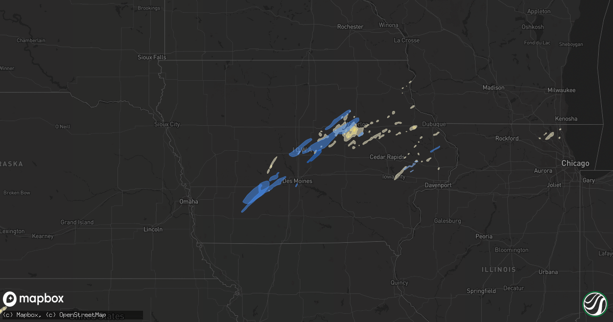
Hail Map in Iowa on September 9, 2019
Get this storm
September 9 map
$229
one time, instant access
Download today. No call, no setup
Keep the $229
Bought the map and want the full workflow? Apply the entire $229 to a subscription within 7 days. None of it is wasted.
Every map, not just this one
This buys you this map. Subscription and you get every map we run, in the markets you choose from a few cities to whole states to nationwide. Plus real-time alerts the moment a storm fires.
Contact data
Name, contact info, occupancy, even credit band for addresses in the footprint. You go from where it hit to who to call.
Become the source they trust
Unlimited branding weather history reports on demand. You already have the documented answer ready for the property owner, and you are the one who showed up with it.
Property data and RoofTrace estimates
Pull up any address you have got, its value and the exact code rules for that jurisdiction, straight from One Click Code. Then RoofTrace estimates the squares, pitch, and roof value, priced the way you price.
Storm reports in Iowa
Iowa
| Date | Description |
|---|---|
| 09/09/20196:33 PM CDT | Several tree limbs... A few large ones... Down throughout the town of shell rock. Some were blocking street. Delayed report and time estimated by radar. |
| 09/09/20196:32 PM CDT | Large tree limb down on a home in clarksville. Delayed report and time estimated by radar. |
| 09/09/20196:25 PM CDT | Trained spotter reports tree damage around conrad and a couple power lines down. Delayed report. Time estimated from radar. |
| 09/09/20196:15 PM CDT | Several large tree limbs down throughout parkersburg and a couple trees reported to have fallen on homes. Delayed report and time estimated by radar. |
| 09/09/20195:50 PM CDT | 10 inch tree limb down on older tree. 3 to 4 inch tree limbs down on newer trees. |
| 09/09/20195:46 PM CDT | Power pole broken at intersection of white pole road and adair street. |
| 09/09/20195:43 PM CDT | Report via social media. |
| 09/09/20195:11 PM CDT | Wall of a building pushed in 6 ft. Damage to the walls and doors. Contents inside blown around. Also trees down. Reported by ames police department. Delayed report. Tim |
| 09/09/20195:01 PM CDT | Large tree down at 10th street and division. |
| 09/09/20194:48 PM CDT | Telephone pole leaned over. No passing sign leaned over. Delayed report. Time estimated from radar. |
| 09/09/20194:43 PM CDT | Branches down in clarinda. One branch fell on power line. |
| 09/09/20194:41 PM CDT | 120th and o ave in page county between stanton and bethesda. Wind damage to 2 large metal buildings and various tree damage. |
| 09/09/20194:38 PM CDT | Updated information: emergency manager drone photos and survey indicate localized downburst wind damage with small areas of flattened crops. Wind caused metal building |
| 09/09/20194:35 PM CDT | 12 inch diameter tree snapped. Relayed by dallas county emergency management. Time estimated from radar. |
| 09/09/20194:08 PM CDT | Several 4 to 6 inch tree limbs down. |
| 09/09/20194:00 PM CDT | Law enforcement reports 4 to 6 inch tree limbs down in menlo. Time estimated from radar. |
| 09/09/20194:30 AM CDT | At 929 PM CDT, severe thunderstorms were located along a line extending from near Lamont to Quasqueton, moving east at 40 mph. At 915 PM, a trained spotter reported wind gusts of 60 MPH and several tree branches down in Independence. HAZARD...60 mph wind gusts. SOURCE...Trained weather spotters. IMPACT...Expect damage to roofs, siding, and trees. Locations impacted include... Manchester, Edgewood, Quasqueton, Lamont, Greeley, Dundee, Delaware, Masonville, Oneida, Winthrop Golf Course, Delaware County Fairgrounds, Manchester Airport, Coffins Grove Park, Twin Bridges Park and Backbone State Park. |
| 09/09/20193:58 AM CDT | At 858 PM CDT, severe thunderstorms were located along a line extending from near Fairbank to near Jesup to near Mount Auburn, moving east at 30 mph. HAZARD...60 mph wind gusts. SOURCE...Radar indicated. IMPACT...Expect damage to roofs, siding, and trees. Locations impacted include... Jesup, La Porte City, Dunkerton and Gilbertville. This includes Interstate 380 between mile markers 56 and 66. |
| 09/09/20193:57 AM CDT | At 856 PM CDT, severe thunderstorms were located along a line extending from near Jesup to near Dysart, moving northeast at 35 mph. HAZARD...60 mph wind gusts. SOURCE...Radar indicated. IMPACT...Expect damage to roofs, siding, and trees. Locations impacted include... Independence, Jesup, Urbana, Dysart, Winthrop, Hazleton, Quasqueton, Brandon, Rowley, Aurora, Mount Auburn, Stanley, Wapsipinicon Golf Course, Fontana County Park, Otterville, Minne Estema Park, Jakway Park, Cheney, Lime Creek County Park and Rodgers Park.This includes Interstate 380 between mile markers 42 and 55. |
| 09/09/20193:55 AM CDT | Dsm public safety reports tree fell on power line causing power flashes in south des moines. |
| 09/09/20193:50 AM CDT | Reports trees down in neighborhood; strong winds over 60 mph. |
| 09/09/20193:37 AM CDT | At 836 PM CDT, a severe thunderstorm was located 9 miles north of State Center, or 14 miles northeast of Nevada, moving northeast at 45 mph. HAZARD...60 mph wind gusts. SOURCE...Radar indicated. IMPACT...Expect damage to roofs, siding, and trees. Locations impacted include... Eldora, Grundy Center, Ackley, Wellsburg, Zearing, Union, Steamboat Rock, Liscomb, Holland, New Providence, Whitten, Clemons, St. Anthony, Pine Lake State Park, Eldora Municipal Airport and Ackley Municipal Airport. |
| 09/09/20193:03 AM CDT | At 803 PM CDT, severe thunderstorms were located along a line extending from near Fredericksburg to 6 miles northwest of Uni-Dome And McLeod Center to near Reinbeck, moving east at 40 mph. HAZARD...60 mph wind gusts. SOURCE...Radar indicated. IMPACT...Expect damage to roofs, siding, and trees. Locations impacted include... Waterloo, Cedar Falls, Waverly, Evansdale, Jesup, La Porte City, Hudson, Sumner, Denver, Traer, Reinbeck, Dysart, Tripoli, Shell Rock, Dike, Elk Run Heights, Waterloo Municipal Airport, Crossroads Mall, Uni-Dome And McLeod Center and Janesville.This includes Interstate 380 between mile markers 56 and 73. |
| 09/09/20192:47 AM CDT | At 747 PM CDT, a severe thunderstorm was located over Jordan Creek Town Center, or over Clive, moving northeast at 50 mph. HAZARD...60 mph wind gusts. SOURCE...Radar indicated. IMPACT...Expect damage to roofs, siding, and trees. Locations impacted include... Des Moines, West Des Moines, Ankeny, Urbandale, Johnston, Clive, Waukee, Grimes, Adel, Windsor Heights, Polk City, Saylorville, Granger, De Soto, Van Meter, Jordan Creek Town Center, Saylorville Lake, Merle Hay Mall, Big Creek Lake and Drake Stadium And Knapp Center.This includes the following highways... Interstate 35 between mile markers 67 and 72, and between milemarkers 87 and 101. Interstate 80 between mile markers 112 and 138. Interstate 235 between mile markers 1 and 7. |
| 09/09/20192:42 AM CDT | At 741 PM CDT, a severe thunderstorm was located near Conrad, or 8 miles north of Marshalltown, moving northeast at 35 mph. HAZARD...60 mph wind gusts. SOURCE...Radar indicated. IMPACT...Expect damage to roofs, siding, and trees. Locations impacted include... Marshalltown, Grundy Center, Traer, Reinbeck, Dike, Conrad, Gladbrook, Holland, Beaman, Lincoln, Green Mountain, Morrison, Marshalltown Municipal Airport, Union Grove State Park and Tf Clark State Park. |
| 09/09/20192:33 AM CDT | At 732 PM CDT, a severe thunderstorm was located near Allison, moving northeast at 85 mph. HAZARD...60 mph wind gusts. SOURCE...Trained weather spotters. At 707 pm trained spotters reported 60 mph wind and damage to large tree limbs south of Hubbard. IMPACT...Expect damage to roofs, siding, and trees. Locations impacted include... Waverly, Allison, Parkersburg, Ackley, Clarksville, Shell Rock, Greene, Aplington, Wellsburg, Dumont, Plainfield, Stout, Frederika, Geneva, Bristow, Bradford, Hansell, Aredale, Allison Municipal Airport and Waverly Municipal Airport. |
| 09/09/20192:21 AM CDT | At 721 PM CDT, severe thunderstorms were located along a line extending from Fairbank to Jesup to near La Porte City, moving east at 35 mph. HAZARD...60 mph wind gusts. SOURCE...Radar indicated. IMPACT...Expect damage to roofs, siding, and trees. Locations impacted include... Independence, Jesup, Fairbank, Winthrop, Hazleton, Quasqueton, Lamont, Brandon, Rowley, Aurora, Stanley, Lime Creek County Park, Winthrop Golf Course, Wapsipinicon Golf Course, Fontana County Park, Littleton, Buchanan County Fairgrounds, Otterville, Independence Airport and Jakway Park.This includes Interstate 380 between mile markers 49 and 55. |
| 09/09/20192:10 AM CDT | At 710 PM CDT, a severe thunderstorm was located 7 miles west of La Porte City, or 10 miles south of Waterloo, moving northeast at 35 mph. HAZARD...70 mph wind gusts. SOURCE...Radar indicated. IMPACT...Expect considerable tree damage. Damage is likely to mobile homes, roofs, and outbuildings. Locations impacted include... Waterloo, Evansdale, Jesup, La Porte City, Elk Run Heights, Washburn, Raymond and Gilbertville.This includes Interstate 380 between mile markers 56 and 69. |
| 09/09/20192:05 AM CDT | At 705 PM CDT, a severe thunderstorm was located 12 miles southwest of Eldora, moving northeast at 50 mph. HAZARD...60 mph wind gusts. SOURCE...Radar indicated. IMPACT...Expect damage to roofs, siding, and trees. Locations impacted include... Iowa Falls, Eldora, Ackley, Hubbard, Wellsburg, Steamboat Rock, New Providence, Garden City, Owasa, Pine Lake State Park, Iowa Falls Municipal Airport, Eldora Municipal Airport and Ackley Municipal Airport. |
| 09/09/20192:00 AM CDT | Corrects previous report. Grain bin collapsed... Multiple trees down. Time estimated from radar. |
| 09/09/20191:48 AM CDT | At 647 PM CDT, severe thunderstorms were located along a line extending from near Tripoli to near Elk Run Heights, moving east at 50 mph. HAZARD...60 mph wind gusts. SOURCE...Radar indicated. IMPACT...Expect damage to roofs, siding, and trees. Locations impacted include... Fairbank, Hazleton, Stanley, Fontana County Park and Fontana Park. |
| 09/09/20191:45 AM CDT | At 645 PM CDT, severe thunderstorms were located along a line extending from near Nashua to near Tripoli to near Evansdale, moving northeast at 50 mph. HAZARD...60 mph wind gusts and penny size hail. SOURCE...Radar indicated. IMPACT...Expect damage to roofs, siding, and trees. Severe thunderstorms will be near... Fredericksburg around 700 PM CDT. New Hampton around 705 PM CDT. Oelwein around 710 PM CDT. West Union around 720 PM CDT. Fayette and Arlington around 725 PM CDT. Other locations impacted by these severe thunderstorms includeDonnan, Eldorado, Randalia, Highways 3 And 187, Republic, WaucomaCampground and County Road W 33 And 187. |
| 09/09/20191:25 AM CDT | At 624 PM CDT, a severe thunderstorm was located near Shell Rock, or 9 miles southwest of Waverly, moving northeast at 50 mph. HAZARD...60 mph wind gusts and penny size hail. SOURCE...Radar indicated. IMPACT...Expect damage to roofs, siding, and trees. Locations impacted include... Waterloo, Cedar Falls, Waverly, Evansdale, Hudson, Sumner, Denver, Tripoli, Shell Rock, Elk Run Heights, Crossroads Mall, Waterloo Municipal Airport, Uni-Dome And McLeod Center, Janesville, Dunkerton, Readlyn, Raymond, Plainfield, Frederika and George Wyth State Park.This includes Interstate 380 between mile markers 69 and 73. |
| 09/09/20191:13 AM CDT | Iowa dot rwis at us 61 and highway 64. |
| 09/09/20191:05 AM CDT | Several trees snapped in delmar. |
| 09/09/20191:00 AM CDT | Trees down. Time estimated from radar. |
| 09/09/201912:54 AM CDT | At 553 PM CDT, a severe thunderstorm was located 9 miles west of Adel, moving northeast at 50 mph. HAZARD...60 mph wind gusts. SOURCE...Radar indicated. IMPACT...Expect damage to roofs, siding, and trees. Locations impacted include... West Des Moines, Ankeny, Urbandale, Johnston, Clive, Waukee, Grimes, Perry, Adel, Polk City, Saylorville, Dallas Center, Earlham, Granger, Panora, De Soto, Woodward, Van Meter, Saylorville Lake and Big Creek Lake.This includes the following highways... Interstate 35 near mile marker 93. Interstate 80 between mile markers 98 and 117, and between milemarkers 126 and 130. |
| 09/09/201912:53 AM CDT | At 553 PM CDT, severe thunderstorms were located along a line extending from 7 miles east of Big Wall Lake to 6 miles east of Eldora to 7 miles southeast of State Center, moving northeast at 50 mph. HAZARD...60 mph wind gusts and penny size hail. SOURCE...Radar indicated. IMPACT...Expect damage to roofs, siding, and trees. Locations impacted include... Iowa Falls, Hampton, Eldora, Grundy Center, Allison, Parkersburg, Reinbeck, Ackley, State Center, Clarksville, Shell Rock, Dike, Sheffield, Greene, Aplington, Conrad, Gladbrook, Alden, Wellsburg and Dumont.This includes Interstate 35 between mile markers 155 and 175. |
| 09/09/201912:48 AM CDT | Few large 5 inch tree limbs down in town. Time estimated from radar. |
| 09/09/201912:30 AM CDT | A few branches and limbs down. Time estimated from radar. |
| 09/09/201912:29 AM CDT | Report via social media. Several large tree branches down in town. Time estimated from radar. |
| 09/09/201912:25 AM CDT | At 525 PM CDT, a severe thunderstorm was located over Greenfield, moving northeast at 55 mph. HAZARD...60 mph wind gusts and penny size hail. SOURCE...Radar indicated. IMPACT...Expect damage to roofs, siding, and trees. Locations impacted include... Creston, Winterset, Greenfield, Stuart, Green Valley Lake, Adair, Fontanelle, Dexter, Casey, Orient, Massena, Menlo, Cumberland, Bridgewater, Macksburg, Cromwell, Greenfield Municipal Airport, Nodaway Park, Green Valley Lake State Park and Winterset-Madison County Airport.This includes Interstate 80 between mile markers 75 and 99. |
| 09/09/201912:21 AM CDT | Tree down on a power line. |
| 09/09/201912:20 AM CDT | At 519 PM CDT, severe thunderstorms were located along a line extending from 8 miles west of Jewell Junction to near Roland to 10 miles west of Baxter, moving northeast at 55 mph. HAZARD...60 mph wind gusts and penny size hail. SOURCE...Radar indicated. IMPACT...Expect damage to roofs, siding, and trees. Locations impacted include... Nevada, Iowa Falls, Eldora, Story City, Ackley, State Center, Roland, Jewell Junction, Colo, Hubbard, Alden, Zearing, Radcliffe, Ellsworth, Collins, Stanhope, Union, Williams, McCallsburg and Steamboat Rock.This includes Interstate 35 between mile markers 117 and 148. |
| 09/09/201912:03 AM CDT | At 503 PM CDT, a severe thunderstorm was located 7 miles northwest of Lake Icaria, or 10 miles northwest of Corning, moving northeast at 50 mph. HAZARD...60 mph wind gusts and penny size hail. SOURCE...Radar indicated. IMPACT...Expect damage to roofs, siding, and trees. Locations impacted include... Greenfield, Anita, Adair, Fontanelle, Massena, Cumberland, Bridgewater, Wiota, Carbon, Lake Anita State Park, Greenfield Municipal Airport, Nodaway Park and Anita Municipal Airport.This includes Interstate 80 between mile markers 66 and 77. |
| 09/09/201912:00 AM CDT | Large tree down. |
| 09/08/201911:47 PM CDT | At 445 PM CDT, a severe thunderstorm was located over Clarinda, or 14 miles west of Bedford, moving northeast at 30 mph. HAZARD...60 mph wind gusts and penny size hail. SOURCE...Trained weather spotters. A 60mph wind gust was reported at the Clarinda Airport. IMPACT...Expect damage to roofs, siding, and trees. Locations impacted include... Corning, Bedford, Lenox, Lake Icaria, New Market, Clearfield, Prescott, Gravity, Nodaway, Sharpsburg, Kent, Conway, Carbon, Lake Of Three Fires State Park, Corning Municipal Airport and Lake Icaria State Park. |
| 09/08/201911:39 PM CDT | At 439 PM CDT, severe thunderstorms were located along a line extending from near Perry to near Granger to Waukee, moving northeast at 30 mph. HAZARD...60 mph wind gusts and penny size hail. SOURCE...Radar indicated. IMPACT...Expect damage to roofs, siding, and trees. Locations impacted include... Ames, Ankeny, Urbandale, Johnston, Clive, Boone, Grimes, Nevada, Polk City, Huxley, Saylorville, Madrid, Ogden, Slater, Granger, Gilbert, Woodward, Iowa State Center, Saylorville Lake and Big Creek Lake.This includes the following highways... Interstate 35 between mile markers 90 and 117. Interstate 80 between mile markers 126 and 132. |
| 09/08/201911:06 PM CDT | At 406 PM CDT, a severe thunderstorm was located over Stuart, or 13 miles northeast of Greenfield, moving northeast at 50 mph. HAZARD...60 mph wind gusts and nickel size hail. SOURCE...Radar indicated. IMPACT...Expect damage to roofs, siding, and trees. Locations impacted include... West Des Moines, Urbandale, Clive, Waukee, Grimes, Perry, Adel, Stuart, Dallas Center, Earlham, Granger, Panora, De Soto, Woodward, Van Meter, Jordan Creek Town Center, Lake Panorama, Redfield, Dexter and Diamondhead Lake.This includes Interstate 80 between mile markers 97 and 122. |
| 09/08/201910:49 PM CDT | At 349 PM CDT, a severe thunderstorm was located near Greenfield, moving northeast at 45 mph. HAZARD...60 mph wind gusts and penny size hail. SOURCE...Radar indicated. IMPACT...Expect damage to roofs, siding, and trees. Locations impacted include... Greenfield, Stuart, Fontanelle, Casey, Menlo, Bridgewater, Greenfield Municipal Airport and Nodaway Park.This includes Interstate 80 between mile markers 81 and 98. |
| 09/08/201910:24 PM CDT | At 324 AM CDT, a severe thunderstorm was located 7 miles southwest of Norwalk, moving northeast at 20 mph. HAZARD...60 mph wind gusts and quarter size hail. SOURCE...Radar indicated. IMPACT...Hail damage to vehicles is expected. Expect wind damage to roofs, siding, and trees. Locations impacted include... Des Moines, West Des Moines, Urbandale, Clive, Waukee, Norwalk, Pleasant Hill, Grimes, Windsor Heights, Southridge Mall, Iowa State Fairgrounds, Principal Park, Des Moines Int'l Airport, Drake Stadium And Knapp Center, Jordan Creek Town Center, Valley West Mall, Merle Hay Mall, Iowa Events Center, Martensdale and Cumming.This includes the following highways... Interstate 35 between mile markers 55 and 72. Interstate 80 between mile markers 116 and 128. Interstate 235 between mile markers 1 and 12. |
| 09/08/20199:55 PM CDT | Delayed report from social media. A few trees and branches down in masonville... Along with 2.2 inches of rain in an hour. Time estimated from radar. |
| 09/08/20199:30 PM CDT | Trees down that knocked power off. Some trees landed on cars in town. |
| 09/08/20199:15 PM CDT | A local report indicates 60 MPH wind near 1 W INDEPENDENCE |
| 09/08/20199:15 PM CDT | Several small to medium size branches down. |
| 09/08/20199:15 PM CDT | Power pole down. Time estimated from radar. |
| 09/08/20198:48 PM CDT | Report just northwest of la porte city on highway 218 near eagle road. |
| 09/08/20198:40 PM CDT | Damage to mobile home skirting. 2.5 inch tree limbs down. Time estimated by radar. |
| 09/08/20198:03 PM CDT | Trees blown down onto highway 76 |
| 09/08/20197:50 PM CDT | Social media report of estimated 60 mph gust. |
| 09/08/20197:43 PM CDT | Asos station kmiw marshalltown airport. |
| 09/08/20197:30 PM CDT | Shed knocked over. Time estimated from radar. |
| 09/08/20197:28 PM CDT | Report from mping: 1-inch tree limbs broken; shingles blown off. |
| 09/08/20197:27 PM CDT | A local report indicates 60 MPH wind near ELK RUN HEIGHTS |
| 09/08/20197:15 PM CDT | Tree limb down across road |
| 09/08/20197:07 PM CDT | Multiple trees down south of hubbard. One of the trees was 24 inches in diameter. Spotter estimated wind gust up to 60 mph. |
| 09/08/20197:02 PM CDT | Asos station kalo waterloo airport. |
All States Impacted by Hail Map on September 9, 2019
Cities Impacted by Hail Map on September 9, 2019
- York, NE
- Letohatchee, AL
- Fort Deposit, AL
- Humboldt, NE
- Dawson, NE
- Greenville, MS
- Lake Village, AR
- Newton, TX
- Winona, KS
- New Raymer, CO
- Hill City, KS
- Lyons, GA
- Emerald Isle, NC
- Johnsonville, SC
- Little Rock, SC
- Hamer, SC
- Fairmont, NC
- Rowland, NC
- Eaton, CO
- Hollandale, MS
- Bennington, NE
- Kennard, NE
- Valley, NE
- Lumberton, NC
- Cedar Falls, IA
- Hudson, IA
- Waterloo, IA
- Jacksonville, NC
- Baton Rouge, LA
- Saint Gabriel, LA
- Prairieville, LA
- Castle Hayne, NC
- Wilmington, NC
- Vidalia, GA
- Monticello, MS
- Jayess, MS
- Petal, MS
- Hattiesburg, MS
- Cordova, SC
- Orangeburg, SC
- Mullins, SC
- Marion, SC
- Woodville, MS
- Hoxie, KS
- Cusseta, GA
- Monument, KS
- Grinnell, KS
- Wallace, KS
- Oakley, KS
- Holly, CO
- Granada, CO
- La Salle, CO
- Leakesville, MS
- Kinder, LA
- Dyersville, IA
- Earlville, IA
- Worthington, IA
- Farley, IA
- Hopkinton, IA
- Hayneville, AL
- Buena Vista, GA
- Grundy Center, IA
- Glenwood, GA
- Monona, IA
- Mead, NE
- Fremont, NE
- Arlington, NE
- Yutan, NE
- Wahoo, NE
- Lineville, AL
- Ashland, AL
- Talladega, AL
- Gresham, SC
- Galivants Ferry, SC
- Morehead City, NC
- Atlantic Beach, NC
- Kersey, CO
- Fort Morgan, CO
- Orchard, CO
- Weldona, CO
- Briggsdale, CO
- Joaquin, TX
- Lingle, WY
- Mchenry, IL
- Roxie, MS
- Hawk Springs, WY
- Whiteville, NC
- Hallsboro, NC
- Clarkton, NC
- Reynolds, GA
- Ideal, GA
- Ashland, NE
- Kinston, NC
- Ulysses, NE
- Jesup, IA
- Fairfax, SC
- Newport, NC
- Mechanicsville, IA
- Lisbon, IA
- Soso, MS
- Havelock, NC
- Rocky Mount, NC
- Elm City, NC
- Perry, IA
- Olla, LA
- Merino, CO
- Pine Bluff, AR
- Dadeville, AL
- Clanton, AL
- Luray, SC
- Estill, SC
- Brunson, SC
- Hampton, SC
- Pineview, GA
- Hawkinsville, GA
- Moselle, MS
- Ellisville, MS
- Greeley, CO
- Gill, CO
- Montrose, GA
- Taylorsville, MS
- Collins, MS
- Mount Olive, MS
- Luverne, AL
- Rutledge, AL
- Greenville, AL
- Ovett, MS
- Richton, MS
- Bogue Chitto, MS
- Ailey, GA
- Mount Vernon, GA
- Strawberry Point, IA
- Evergreen, AL
- Brewton, AL
- Columbia, MS
- Bassfield, MS
- Carson, MS
- Call, TX
- Buckhead, GA
- Scribner, NE
- Elkhorn, NE
- Dermott, AR
- Rayville, LA
- Lake Waccamaw, NC
- Richland, GA
- Castleberry, AL
- Fleming, CO
- Burgaw, NC
- Rolling Fork, MS
- Yazoo City, MS
- Holly Bluff, MS
- Silver Creek, MS
- Newhebron, MS
- Emporia, VA
- Branchville, VA
- Freeman, VA
- Margarettsville, NC
- Laurel, MS
- Waynesboro, MS
- Shubuta, MS
- Hubert, NC
- Sterling, CO
- Iliff, CO
- Stoneham, CO
- Snyder, CO
- Jena, LA
- Trout, LA
- Torrington, WY
- Yoder, WY
- Veteran, WY
- Omaha, GA
- Pittsview, AL
- Lumpkin, GA
- Fort Mitchell, AL
- Hermanville, MS
- Maplesville, AL
- Franklin, VA
- Union Church, MS
- Barneveld, WI
- Blue Mounds, WI
- Dublin, GA
- Camp Lejeune, NC
- Rupert, GA
- Bastrop, LA
- Woodstock, IL
- Platteville, CO
- Tarrytown, GA
- Sumrall, MS
- Natchez, MS
- Crosby, MS
- Minter, AL
- Rhine, GA
- Milan, GA
- Rochelle, GA
- Abbeville, GA
- Wilson, NC
- Morland, KS
- Cascade, IA
- Bernard, IA
- Anamosa, IA
- Rexford, KS
- Mauk, GA
- Cobbtown, GA
- Traer, IA
- Dysart, IA
- Statesboro, GA
- Verbena, AL
- Pinetown, NC
- Hamburg, AR
- Crossett, AR
- Pollock, LA
- Albany, GA
- Rupert, ID
- Pilger, NE
- Pink Hill, NC
- Kenansville, NC
- Beulaville, NC
- Billingsley, AL
- Madison, MS
- Canton, MS
- Shirley, AR
- Alamo, GA
- Murfreesboro, NC
- Winnfield, LA
- Kelly, LA
- Brainard, NE
- Staplehurst, NE
- Gresham, NE
- David City, NE
- Dwight, NE
- Bladenboro, NC
- Browns Valley, MN
- Sisseton, SD
- Monticello, IA
- Center Junction, IA
- Avoca, WI
- Tar Heel, NC
- Elizabethtown, NC
- Bath, NC
- Washington, NC
- Conrad, IA
- Union, IA
- New Providence, IA
- Eldora, IA
- Tifton, GA
- Preston, GA
- Council, NC
- Riegelwood, NC
- Fort Benning, GA
- Glen Haven, WI
- Portland, AR
- Thomasville, AL
- Kelly, NC
- Kelford, NC
- Lewiston Woodville, NC
- De Witt, IA
- Midway Park, NC
- Tarawa Terrace, NC
- Albertson, NC
- Sylvester, GA
- Baxley, GA
- Stratford, SD
- Janesville, IA
- Register, GA
- Deep Run, NC
- Snow Hill, NC
- La Grange, NC
- Pembroke, GA
- Fort Myers, FL
- Lehigh Acres, FL
- Waterloo, NE
- Deatsville, AL
- Marbury, AL
- Geismar, LA
- Madison, NE
- Ashburn, GA
- Dodson, LA
- Sikes, LA
- Harrells, NC
- Eastman, GA
- Penokee, KS
- Wilmot, AR
- Early Branch, SC
- Millen, GA
- Rentz, GA
- Waverly, IA
- Libertyville, IL
- Vernon Hills, IL
- Mundelein, IL
- Ithaca, NE
- Mount Olive, NC
- Pioneer, LA
- Reinbeck, IA
- Omaha, NE
- Danville, GA
- Hazlehurst, MS
- Georgetown, MS
- Jesup, GA
- Dumont, MN
- Sontag, MS
- Cheyenne, WY
- McRae Helena, GA
- Hazelton, ID
- Jerome, ID
- Savannah, GA
- Bloomingdale, GA
- Alma, GA
- Gunnison, MS
- Utica, MS
- Ryan, IA
- Manchester, IA
- Stanton, NE
- Meadville, MS
- Fitzgerald, GA
- Ahoskie, NC
- Pattison, MS
- Fayette, MS
- Lorman, MS
- Americus, GA
- Plains, GA
- Eatonton, GA
- La Porte City, IA
- Brenham, TX
- Alva, FL
- Clio, SC
- Albion, IA
- Cobb, GA
- Manning, SC
- Red Level, AL
- Andalusia, AL
- Butler, GA
- La Motte, IA
- Zwingle, IA
- Bellevue, IA
- Ruffin, SC
- Jackson, AL
- Grosse Tete, LA
- Plaquemine, LA
- Farmersburg, IA
- Andrews, TX
- Ralls, TX
- Ludowici, GA
- Eudora, AR
- Seale, AL
- Grady, AL
- Aurora, NC
- Edward, NC
- Blounts Creek, NC
- Allendale, SC
- Chula, GA
- Merryville, LA
- Shullsburg, WI
- Brookeland, TX
- Shell Rock, IA
- New Hartford, IA
- Livingston, LA
- Groton, SD
- Andover, SD
- Pierpont, SD
- Bentonia, MS
- De Berry, TX
- Carthage, TX
- Grayslake, IL
- Round Lake, IL
- Wauconda, IL
- Ingleside, IL
- Ellaville, GA
- Soperton, GA
- Brandon, IA
- Pinola, MS
- Currie, NC
- Beaufort, NC
- Shelby, NE
- Hemphill, TX
- Cameron, SC
- Mize, MS
- Verona, WI
- Round O, SC
- Utica, NE
- Rising City, NE
- Sandersville, GA
- Tennille, GA
- Flora, MS
- Arabi, GA
- Toomsboro, GA
- Clarence, IA
- Lowden, IA
- Crystal Lake, IL
- Fox Lake, IL
- Cary, IL
- Island Lake, IL
- Port Allen, LA
- Hatchechubbee, AL
- Brookhaven, MS
- Gurnee, IL
- Wadsworth, IL
- Wray, GA
- Columbus, NE
- Wisner, NE
- Box Springs, GA
- Brooklet, GA
- Union Springs, AL
- Highland Home, AL
- Greensboro, GA
- Gilbertville, IA
- Dike, IA
- Holland, IA
- Parkersburg, IA
- Buckingham, IA
- Dawson, IA
- Linden, IA
- Oak Vale, MS
- Winthrop, IA
- Quasqueton, IA
- Rowley, IA
- Belhaven, NC
- Jay Em, WY
- Pendleton, NC
- Conway, NC
- Clutier, IA
- Waco, NE
- Camden, AL
- Stella, NC
- Swansboro, NC
- Vinton, IA
- Mount Auburn, IA
- Coggon, IA
- Walker, IA
- Garrison, IA
- Smoaks, SC
- Bon Wier, TX
- Grove Hill, AL
- Oglethorpe, GA
- Quitman, LA
- Harpers Ferry, IA
- Sparta, GA
- Masonville, IA
- Hazleton, IA
- Independence, IA
- Metter, GA
- Mount Horeb, WI
- Peru, NE
- Brownville, NE
- Louin, MS
- Oakfield, GA
- Ayden, NC
- Delmar, IA
- Lost Nation, IA
- Wheatland, IA
- Selden, KS
- Florien, LA
- Many, LA
- Chesterfield, SC
- Rocky Point, NC
- Clinton, AR
- Richlands, NC
- Guttenberg, IA
- West Branch, IA
- Tipton, IA
- Iowa City, IA
- Baker, LA
- Walterboro, SC
- Hooper, NE
- Herman, NE
- Prattville, AL
- Drewryville, VA
- Boykins, VA
- Clio, AL
- Louisville, AL
- Saint Stephens, AL
- Harrisonburg, LA
- Grayson, LA
- Warwick, GA
- Leesburg, GA
- Colo, IA
- State Center, IA
- Richards, TX
- Wyoming, IA
- Oxford Junction, IA
- Ivanhoe, NC
- Atkinson, NC
- Port Wentworth, GA
- Pooler, GA
- Seminary, MS
- Plantersville, AL
- Islandton, SC
- Franklinton, LA
- Lamont, IA
- Dexter, IA
- Andersonville, GA
- Prentiss, MS
- Marshalltown, IA
- Beaman, IA
- Sylvania, GA
- Satartia, MS
- Ogden, IA
- Donnelly, MN
- Mansfield, LA
- Logansport, LA
- Twin Falls, ID
- Hansen, ID
- Filer, ID
- Paul, ID
- Eden, ID
- Kimberly, ID
- Earlham, IA
- Van Meter, IA
- Adair, IA
- Waukee, IA
- Bridgewater, IA
- Fontanelle, IA
- Casey, IA
- De Soto, IA
- Greenfield, IA
- Dallas Center, IA
- Adel, IA
- Anita, IA
- Clive, IA
- Stuart, IA
- Menlo, IA
- Urbandale, IA
- Massena, IA
- Minburn, IA
- Redfield, IA
- Ames, IA
- McCallsburg, IA
- Garden City, IA
- Boone, IA
- Gilbert, IA
- Radcliffe, IA
- Hubbard, IA
- Nevada, IA
- Story City, IA
- Roland, IA
- Clemons, IA
- Saint Anthony, IA
- Zearing, IA
- Liscomb, IA
- Morrison, IA
- Whitten, IA
- Collins, IA
- Maxwell, IA
- Corning, IA
- Aplington, IA
- Steamboat Rock, IA
- Wellsburg, IA
- Stanwood, IA
- Maquoketa, IA
- Spragueville, IA
- Des Moines, IA
- Norwalk, IA
- Tyro, VA
- Lyndhurst, VA
- Roseland, VA
- Raleigh, MS
- Morton, MS
- Brandon, MS
- Cross Plains, WI
- Middleton, WI
- Madison, WI
- Walworth, WI
- Williams Bay, WI
- Fontana, WI
- Hayti, SD
- Bristol, SD


