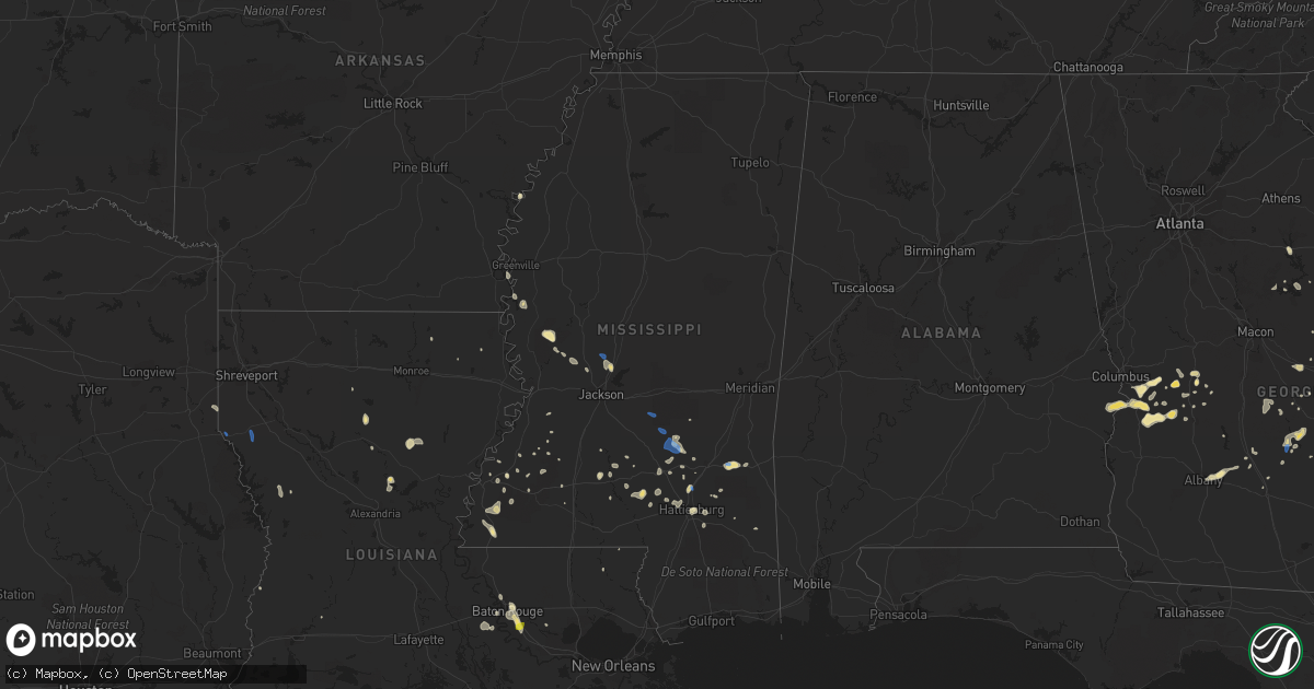
Hail Map in Mississippi on September 9, 2019
Get this storm
September 9 map
$229
one time, instant access
Download today. No call, no setup
Keep the $229
Bought the map and want the full workflow? Apply the entire $229 to a subscription within 7 days. None of it is wasted.
Every map, not just this one
This buys you this map. Subscription and you get every map we run, in the markets you choose from a few cities to whole states to nationwide. Plus real-time alerts the moment a storm fires.
Contact data
Name, contact info, occupancy, even credit band for addresses in the footprint. You go from where it hit to who to call.
Become the source they trust
Unlimited branding weather history reports on demand. You already have the documented answer ready for the property owner, and you are the one who showed up with it.
Property data and RoofTrace estimates
Pull up any address you have got, its value and the exact code rules for that jurisdiction, straight from One Click Code. Then RoofTrace estimates the squares, pitch, and roof value, priced the way you price.
Storm reports in Mississippi
Mississippi
| Date | Description |
|---|---|
| 09/09/20196:18 PM CDT | A few trees down with one down on a vehicle. A few others had the tops blown out. Power lines were down along with dime to penny size hail. |
| 09/09/20196:08 PM CDT | Tree down at stokes road and cloud road. |
| 09/09/20195:40 PM CDT | Few trees down on chapel hill road. |
| 09/09/20195:35 PM CDT | Powerline down at gunter road and old natchez trace. Due to outflow winds and likely sub severe wind gusts. |
| 09/09/20195:22 PM CDT | Tree down on n old canton road. Due to outflow winds and likely sub severe wind gusts. |
| 09/09/20195:07 PM CDT | Trees down s of polkville. |
| 09/09/20194:52 PM CDT | Tree down on columbia avenue. |
| 09/09/20194:50 PM CDT | Several trees down along hwy 503. |
| 09/09/20194:30 PM CDT | Around 5-6 trees down... With some large limbs downed as well. Mainly on rural roads near magee... South of mendenhall and near the braxton area. |
| 09/09/20194:06 PM CDT | Tree down along hwy 84 east of collins at cutoff rd. |
| 09/09/20194:02 PM CDT | Trees and power lines down in the mize area. |
| 09/09/20193:45 PM CDT | Fencing blown down along with damage to the batting cages. |
| 09/09/20193:00 PM CDT | Trees reported down on old highway 84 loop road and pleasant grove road. |
| 09/09/20192:50 PM CDT | Trees down on hwy 11 @ beasly rd. There is also damage to moselle elementary school. |
| 09/09/20192:49 PM CDT | *** 1 inj *** an awning was downed at moselle elementary school... Striking a teacher. The teacher sustained a minor injury... But refused to be transported to the loca |
| 09/09/20191:10 AM CDT | At 609 PM CDT, a severe thunderstorm was located over Holly Bluff, or 10 miles east of Rolling Fork, moving northwest at 25 mph. HAZARD...60 mph wind gusts and penny size hail. SOURCE...Radar indicated. IMPACT...Expect damage to roofs, siding, and trees. This severe thunderstorm will be near... Rolling Fork around 630 PM CDT. Anguilla around 635 PM CDT. Nitta Yuma around 645 PM CDT. Delta City around 650 PM CDT. Panther Burn around 655 PM CDT. |
| 09/09/20191:08 AM CDT | At 608 PM CDT, a severe thunderstorm was located near Myrleville, or 12 miles northwest of Canton, moving north at 20 mph. HAZARD...60 mph wind gusts and penny size hail. SOURCE...Radar indicated. IMPACT...Expect damage to roofs, siding, and trees. This severe thunderstorm will be near... Benton around 630 PM CDT.Other locations impacted by this severe thunderstorm include Eden. |
| 09/08/201911:45 PM CDT | At 445 PM CDT, a severe thunderstorm was located over Robinwood, or 21 miles east of Brookhaven, moving west at 20 mph. HAZARD...60 mph wind gusts and penny size hail. SOURCE...Radar indicated. IMPACT...Expect damage to roofs, siding, and trees. This severe thunderstorm will be near... Monticello around 450 PM CDT. Topeka around 500 PM CDT.Other locations impacted by this severe thunderstorm include SilverCreek. |
| 09/08/201911:44 PM CDT | At 444 PM CDT, a severe thunderstorm was located near White Oak, or 9 miles northeast of Mendenhall, moving northwest at 15 mph. HAZARD...60 mph wind gusts and penny size hail. SOURCE...Radar indicated. IMPACT...Expect damage to roofs, siding, and trees. This severe thunderstorm will be near... Johns and Cato around 515 PM CDT.Other locations impacted by this severe thunderstorm includePolkville and Puckett. |
| 09/08/201911:09 PM CDT | At 409 PM CDT, a severe thunderstorm was located near Magee, moving west at 25 mph. HAZARD...60 mph wind gusts and penny size hail. SOURCE...Radar indicated. IMPACT...Expect damage to roofs, siding, and trees. This severe thunderstorm will be near... Magee around 415 PM CDT. Sanatorium and Martinville around 425 PM CDT. Mendenhall around 440 PM CDT. Pinola around 450 PM CDT.Other locations impacted by this severe thunderstorm include D'Lo. |
| 09/08/201911:06 PM CDT | At 406 PM CDT, a severe thunderstorm was located over Prentiss, or 16 miles west of Collins, moving west at 25 mph. HAZARD...60 mph wind gusts and quarter size hail. SOURCE...Radar indicated. IMPACT...Hail damage to vehicles is expected. Expect wind damage to roofs, siding, and trees. This severe thunderstorm will be near... Prentiss around 410 PM CDT. Progress around 420 PM CDT. Monticello around 440 PM CDT.Other locations impacted by this severe thunderstorm includeBassfield, New Hebron and Silver Creek. |
| 09/08/201910:55 PM CDT | At 355 PM CDT, a severe thunderstorm was located near Taylorsville, or 11 miles east of Magee, moving northwest at 25 mph. HAZARD...60 mph wind gusts. SOURCE...Radar indicated. IMPACT...Expect damage to roofs, siding, and trees. This severe thunderstorm will be near... Center Ridge around 400 PM CDT.Other locations impacted by this severe thunderstorm include Mize. |
| 09/08/20199:43 PM CDT | At 243 PM CDT, a severe thunderstorm was located 7 miles east of Mill Creek, or 11 miles west of Waynesboro, moving west at 10 mph. HAZARD...60 mph wind gusts. SOURCE...Radar indicated. IMPACT...Expect damage to roofs, siding, and trees. This severe thunderstorm will remain over mainly rural areas of northwestern Wayne County. |
All States Impacted by Hail Map on September 9, 2019
Cities Impacted by Hail Map on September 9, 2019
- York, NE
- Letohatchee, AL
- Fort Deposit, AL
- Humboldt, NE
- Dawson, NE
- Greenville, MS
- Lake Village, AR
- Newton, TX
- Winona, KS
- New Raymer, CO
- Hill City, KS
- Lyons, GA
- Emerald Isle, NC
- Johnsonville, SC
- Little Rock, SC
- Hamer, SC
- Fairmont, NC
- Rowland, NC
- Eaton, CO
- Hollandale, MS
- Bennington, NE
- Kennard, NE
- Valley, NE
- Lumberton, NC
- Cedar Falls, IA
- Hudson, IA
- Waterloo, IA
- Jacksonville, NC
- Baton Rouge, LA
- Saint Gabriel, LA
- Prairieville, LA
- Castle Hayne, NC
- Wilmington, NC
- Vidalia, GA
- Monticello, MS
- Jayess, MS
- Petal, MS
- Hattiesburg, MS
- Cordova, SC
- Orangeburg, SC
- Mullins, SC
- Marion, SC
- Woodville, MS
- Hoxie, KS
- Cusseta, GA
- Monument, KS
- Grinnell, KS
- Wallace, KS
- Oakley, KS
- Holly, CO
- Granada, CO
- La Salle, CO
- Leakesville, MS
- Kinder, LA
- Dyersville, IA
- Earlville, IA
- Worthington, IA
- Farley, IA
- Hopkinton, IA
- Hayneville, AL
- Buena Vista, GA
- Grundy Center, IA
- Glenwood, GA
- Monona, IA
- Mead, NE
- Fremont, NE
- Arlington, NE
- Yutan, NE
- Wahoo, NE
- Lineville, AL
- Ashland, AL
- Talladega, AL
- Gresham, SC
- Galivants Ferry, SC
- Morehead City, NC
- Atlantic Beach, NC
- Kersey, CO
- Fort Morgan, CO
- Orchard, CO
- Weldona, CO
- Briggsdale, CO
- Joaquin, TX
- Lingle, WY
- Mchenry, IL
- Roxie, MS
- Hawk Springs, WY
- Whiteville, NC
- Hallsboro, NC
- Clarkton, NC
- Reynolds, GA
- Ideal, GA
- Ashland, NE
- Kinston, NC
- Ulysses, NE
- Jesup, IA
- Fairfax, SC
- Newport, NC
- Mechanicsville, IA
- Lisbon, IA
- Soso, MS
- Havelock, NC
- Rocky Mount, NC
- Elm City, NC
- Perry, IA
- Olla, LA
- Merino, CO
- Pine Bluff, AR
- Dadeville, AL
- Clanton, AL
- Luray, SC
- Estill, SC
- Brunson, SC
- Hampton, SC
- Pineview, GA
- Hawkinsville, GA
- Moselle, MS
- Ellisville, MS
- Greeley, CO
- Gill, CO
- Montrose, GA
- Taylorsville, MS
- Collins, MS
- Mount Olive, MS
- Luverne, AL
- Rutledge, AL
- Greenville, AL
- Ovett, MS
- Richton, MS
- Bogue Chitto, MS
- Ailey, GA
- Mount Vernon, GA
- Strawberry Point, IA
- Evergreen, AL
- Brewton, AL
- Columbia, MS
- Bassfield, MS
- Carson, MS
- Call, TX
- Buckhead, GA
- Scribner, NE
- Elkhorn, NE
- Dermott, AR
- Rayville, LA
- Lake Waccamaw, NC
- Richland, GA
- Castleberry, AL
- Fleming, CO
- Burgaw, NC
- Rolling Fork, MS
- Yazoo City, MS
- Holly Bluff, MS
- Silver Creek, MS
- Newhebron, MS
- Emporia, VA
- Branchville, VA
- Freeman, VA
- Margarettsville, NC
- Laurel, MS
- Waynesboro, MS
- Shubuta, MS
- Hubert, NC
- Sterling, CO
- Iliff, CO
- Stoneham, CO
- Snyder, CO
- Jena, LA
- Trout, LA
- Torrington, WY
- Yoder, WY
- Veteran, WY
- Omaha, GA
- Pittsview, AL
- Lumpkin, GA
- Fort Mitchell, AL
- Hermanville, MS
- Maplesville, AL
- Franklin, VA
- Union Church, MS
- Barneveld, WI
- Blue Mounds, WI
- Dublin, GA
- Camp Lejeune, NC
- Rupert, GA
- Bastrop, LA
- Woodstock, IL
- Platteville, CO
- Tarrytown, GA
- Sumrall, MS
- Natchez, MS
- Crosby, MS
- Minter, AL
- Rhine, GA
- Milan, GA
- Rochelle, GA
- Abbeville, GA
- Wilson, NC
- Morland, KS
- Cascade, IA
- Bernard, IA
- Anamosa, IA
- Rexford, KS
- Mauk, GA
- Cobbtown, GA
- Traer, IA
- Dysart, IA
- Statesboro, GA
- Verbena, AL
- Pinetown, NC
- Hamburg, AR
- Crossett, AR
- Pollock, LA
- Albany, GA
- Rupert, ID
- Pilger, NE
- Pink Hill, NC
- Kenansville, NC
- Beulaville, NC
- Billingsley, AL
- Madison, MS
- Canton, MS
- Shirley, AR
- Alamo, GA
- Murfreesboro, NC
- Winnfield, LA
- Kelly, LA
- Brainard, NE
- Staplehurst, NE
- Gresham, NE
- David City, NE
- Dwight, NE
- Bladenboro, NC
- Browns Valley, MN
- Sisseton, SD
- Monticello, IA
- Center Junction, IA
- Avoca, WI
- Tar Heel, NC
- Elizabethtown, NC
- Bath, NC
- Washington, NC
- Conrad, IA
- Union, IA
- New Providence, IA
- Eldora, IA
- Tifton, GA
- Preston, GA
- Council, NC
- Riegelwood, NC
- Fort Benning, GA
- Glen Haven, WI
- Portland, AR
- Thomasville, AL
- Kelly, NC
- Kelford, NC
- Lewiston Woodville, NC
- De Witt, IA
- Midway Park, NC
- Tarawa Terrace, NC
- Albertson, NC
- Sylvester, GA
- Baxley, GA
- Stratford, SD
- Janesville, IA
- Register, GA
- Deep Run, NC
- Snow Hill, NC
- La Grange, NC
- Pembroke, GA
- Fort Myers, FL
- Lehigh Acres, FL
- Waterloo, NE
- Deatsville, AL
- Marbury, AL
- Geismar, LA
- Madison, NE
- Ashburn, GA
- Dodson, LA
- Sikes, LA
- Harrells, NC
- Eastman, GA
- Penokee, KS
- Wilmot, AR
- Early Branch, SC
- Millen, GA
- Rentz, GA
- Waverly, IA
- Libertyville, IL
- Vernon Hills, IL
- Mundelein, IL
- Ithaca, NE
- Mount Olive, NC
- Pioneer, LA
- Reinbeck, IA
- Omaha, NE
- Danville, GA
- Hazlehurst, MS
- Georgetown, MS
- Jesup, GA
- Dumont, MN
- Sontag, MS
- Cheyenne, WY
- McRae Helena, GA
- Hazelton, ID
- Jerome, ID
- Savannah, GA
- Bloomingdale, GA
- Alma, GA
- Gunnison, MS
- Utica, MS
- Ryan, IA
- Manchester, IA
- Stanton, NE
- Meadville, MS
- Fitzgerald, GA
- Ahoskie, NC
- Pattison, MS
- Fayette, MS
- Lorman, MS
- Americus, GA
- Plains, GA
- Eatonton, GA
- La Porte City, IA
- Brenham, TX
- Alva, FL
- Clio, SC
- Albion, IA
- Cobb, GA
- Manning, SC
- Red Level, AL
- Andalusia, AL
- Butler, GA
- La Motte, IA
- Zwingle, IA
- Bellevue, IA
- Ruffin, SC
- Jackson, AL
- Grosse Tete, LA
- Plaquemine, LA
- Farmersburg, IA
- Andrews, TX
- Ralls, TX
- Ludowici, GA
- Eudora, AR
- Seale, AL
- Grady, AL
- Aurora, NC
- Edward, NC
- Blounts Creek, NC
- Allendale, SC
- Chula, GA
- Merryville, LA
- Shullsburg, WI
- Brookeland, TX
- Shell Rock, IA
- New Hartford, IA
- Livingston, LA
- Groton, SD
- Andover, SD
- Pierpont, SD
- Bentonia, MS
- De Berry, TX
- Carthage, TX
- Grayslake, IL
- Round Lake, IL
- Wauconda, IL
- Ingleside, IL
- Ellaville, GA
- Soperton, GA
- Brandon, IA
- Pinola, MS
- Currie, NC
- Beaufort, NC
- Shelby, NE
- Hemphill, TX
- Cameron, SC
- Mize, MS
- Verona, WI
- Round O, SC
- Utica, NE
- Rising City, NE
- Sandersville, GA
- Tennille, GA
- Flora, MS
- Arabi, GA
- Toomsboro, GA
- Clarence, IA
- Lowden, IA
- Crystal Lake, IL
- Fox Lake, IL
- Cary, IL
- Island Lake, IL
- Port Allen, LA
- Hatchechubbee, AL
- Brookhaven, MS
- Gurnee, IL
- Wadsworth, IL
- Wray, GA
- Columbus, NE
- Wisner, NE
- Box Springs, GA
- Brooklet, GA
- Union Springs, AL
- Highland Home, AL
- Greensboro, GA
- Gilbertville, IA
- Dike, IA
- Holland, IA
- Parkersburg, IA
- Buckingham, IA
- Dawson, IA
- Linden, IA
- Oak Vale, MS
- Winthrop, IA
- Quasqueton, IA
- Rowley, IA
- Belhaven, NC
- Jay Em, WY
- Pendleton, NC
- Conway, NC
- Clutier, IA
- Waco, NE
- Camden, AL
- Stella, NC
- Swansboro, NC
- Vinton, IA
- Mount Auburn, IA
- Coggon, IA
- Walker, IA
- Garrison, IA
- Smoaks, SC
- Bon Wier, TX
- Grove Hill, AL
- Oglethorpe, GA
- Quitman, LA
- Harpers Ferry, IA
- Sparta, GA
- Masonville, IA
- Hazleton, IA
- Independence, IA
- Metter, GA
- Mount Horeb, WI
- Peru, NE
- Brownville, NE
- Louin, MS
- Oakfield, GA
- Ayden, NC
- Delmar, IA
- Lost Nation, IA
- Wheatland, IA
- Selden, KS
- Florien, LA
- Many, LA
- Chesterfield, SC
- Rocky Point, NC
- Clinton, AR
- Richlands, NC
- Guttenberg, IA
- West Branch, IA
- Tipton, IA
- Iowa City, IA
- Baker, LA
- Walterboro, SC
- Hooper, NE
- Herman, NE
- Prattville, AL
- Drewryville, VA
- Boykins, VA
- Clio, AL
- Louisville, AL
- Saint Stephens, AL
- Harrisonburg, LA
- Grayson, LA
- Warwick, GA
- Leesburg, GA
- Colo, IA
- State Center, IA
- Richards, TX
- Wyoming, IA
- Oxford Junction, IA
- Ivanhoe, NC
- Atkinson, NC
- Port Wentworth, GA
- Pooler, GA
- Seminary, MS
- Plantersville, AL
- Islandton, SC
- Franklinton, LA
- Lamont, IA
- Dexter, IA
- Andersonville, GA
- Prentiss, MS
- Marshalltown, IA
- Beaman, IA
- Sylvania, GA
- Satartia, MS
- Ogden, IA
- Donnelly, MN
- Mansfield, LA
- Logansport, LA
- Twin Falls, ID
- Hansen, ID
- Filer, ID
- Paul, ID
- Eden, ID
- Kimberly, ID
- Earlham, IA
- Van Meter, IA
- Adair, IA
- Waukee, IA
- Bridgewater, IA
- Fontanelle, IA
- Casey, IA
- De Soto, IA
- Greenfield, IA
- Dallas Center, IA
- Adel, IA
- Anita, IA
- Clive, IA
- Stuart, IA
- Menlo, IA
- Urbandale, IA
- Massena, IA
- Minburn, IA
- Redfield, IA
- Ames, IA
- McCallsburg, IA
- Garden City, IA
- Boone, IA
- Gilbert, IA
- Radcliffe, IA
- Hubbard, IA
- Nevada, IA
- Story City, IA
- Roland, IA
- Clemons, IA
- Saint Anthony, IA
- Zearing, IA
- Liscomb, IA
- Morrison, IA
- Whitten, IA
- Collins, IA
- Maxwell, IA
- Corning, IA
- Aplington, IA
- Steamboat Rock, IA
- Wellsburg, IA
- Stanwood, IA
- Maquoketa, IA
- Spragueville, IA
- Des Moines, IA
- Norwalk, IA
- Tyro, VA
- Lyndhurst, VA
- Roseland, VA
- Raleigh, MS
- Morton, MS
- Brandon, MS
- Cross Plains, WI
- Middleton, WI
- Madison, WI
- Walworth, WI
- Williams Bay, WI
- Fontana, WI
- Hayti, SD
- Bristol, SD


