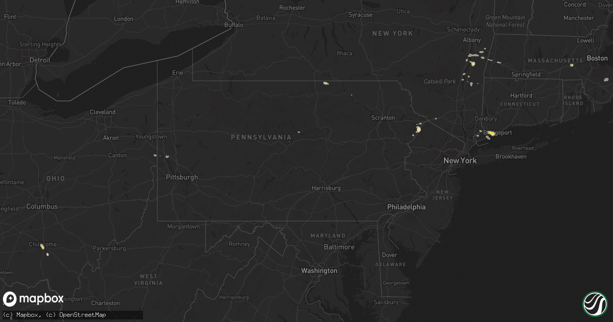
Hail Map in Pennsylvania on September 6, 2018
Get this storm
September 6 map
$229
one time, instant access
Download today. No call, no setup
Keep the $229
Bought the map and want the full workflow? Apply the entire $229 to a subscription within 7 days. None of it is wasted.
Every map, not just this one
This buys you this map. Subscription and you get every map we run, in the markets you choose from a few cities to whole states to nationwide. Plus real-time alerts the moment a storm fires.
Contact data
Name, contact info, occupancy, even credit band for addresses in the footprint. You go from where it hit to who to call.
Become the source they trust
Unlimited branding weather history reports on demand. You already have the documented answer ready for the property owner, and you are the one who showed up with it.
Property data and RoofTrace estimates
Pull up any address you have got, its value and the exact code rules for that jurisdiction, straight from One Click Code. Then RoofTrace estimates the squares, pitch, and roof value, priced the way you price.
Storm reports in Pennsylvania
Pennsylvania
| Date | Description |
|---|---|
| 09/06/20183:52 PM CDT | Trees reported down in east hanover township. Confirmed with dauphin county 911 call center. |
| 09/06/20183:38 PM CDT | Trees and large branches down along iams station road from very strong thunderstorm wind |
| 09/06/20183:37 PM CDT | Trees and large branches down around the area of mccullough rd. Wind also ripped a nailed-down tarp off a roof in this area. |
| 09/06/20183:35 PM CDT | Trees and power lines down. |
| 09/06/20183:35 PM CDT | Widespread branches down and power out along andrews rd from very strong thunderstorm wind gusts. |
| 09/06/20183:30 PM CDT | Uprooted and snapped trees photographed along beulah ridge road associated with a downburst |
| 09/05/201811:32 PM CDT | At 432 PM EDT, a severe thunderstorm was located 10 miles northwest of Waynesburg, moving east at 15 mph. HAZARD...Wind gusts to 60 mph and quarter-size hail. SOURCE...Radar. IMPACT...Minor hail damage to vehicles is possible. Expect wind damage to trees and power lines, resulting in some power outages. Locations impacted include... Marianna... Amity...This includes Interstate 79 in Pennsylvania between mile markers 16and 24. |
| 09/05/201811:29 PM CDT | At 428 PM EDT, a severe thunderstorm was located over Dingmans Ferry, or 7 miles southwest of Montague, moving southeast at 10 mph. HAZARD...60 mph wind gusts and nickel size hail. SOURCE...Radar indicated. IMPACT...Damage to roofs, siding, trees, and power lines is possible. Locations impacted include... Branchville, Crandon Lakes and Hainesville. |
| 09/05/201810:23 PM CDT | At 323 PM EDT, a severe thunderstorm was located over West Liberty, moving east at 10 mph. HAZARD...Wind gusts to 60 mph and quarter-size hail. SOURCE...Radar. IMPACT...Minor hail damage to vehicles is possible. Expect wind damage to trees and power lines, resulting in some power outages. Locations impacted include... Wellsburg... West Liberty... Avella... Wolfdale... Bethany... Claysville... Franklin... Hickory... West Alexander... Taylorstown... West Middletown... Green Hills...This includes Interstate 70 in Pennsylvania between mile markers 1and 15. |
| 09/05/20189:46 PM CDT | At 246 PM EDT, a severe thunderstorm was located over Gillett, or 10 miles southwest of Chemung, moving east at 25 mph. HAZARD...60 mph wind gusts and quarter size hail. SOURCE...Radar indicated. IMPACT...Hail damage to vehicles is expected. Expect wind damage to roofs, siding, and trees. This severe thunderstorm will be near... Ridgebury around 255 PM EDT. Springfield around 300 PM EDT. Wetona around 305 PM EDT. East Smithfield around 310 PM EDT. Athens, Ulster and Milan around 315 PM EDT. |
| 09/05/20189:17 PM CDT | At 216 PM EDT, a severe thunderstorm was located over Compton, or near Wyalusing, moving east at 25 mph. HAZARD...60 mph wind gusts and quarter size hail. SOURCE...Radar indicated. IMPACT...Hail damage to vehicles is expected. Expect wind damage to roofs, siding, and trees. This severe thunderstorm will be near... Rushville around 220 PM EDT. Laceyville around 225 PM EDT. Meshoppen and Auburn Center around 240 PM EDT. Springville and Lake Carey around 245 PM EDT. |
| 09/05/20188:40 PM CDT | At 139 PM EDT, a severe thunderstorm was located over Pittston, moving east at 15 mph. HAZARD...60 mph wind gusts and quarter size hail. SOURCE...Radar indicated. IMPACT...Hail damage to vehicles is expected. Expect wind damage to roofs, siding, and trees. This severe thunderstorm will be near... Moosic and Glendale around 155 PM EDT. Dunmore around 210 PM EDT. Elmhurst around 225 PM EDT. Moscow, Lehigh and Gouldsboro around 230 PM EDT. |
All States Impacted by Hail Map on September 6, 2018
Cities Impacted by Hail Map on September 6, 2018
- Yazoo City, MS
- Silver City, MS
- Hebron, ND
- Glen Ullin, ND
- Richardton, ND
- Churchs Ferry, ND
- Devils Lake, ND
- Beulah, ND
- Zap, ND
- Auburn, KY
- Russellville, KY
- Topsham, ME
- Ezel, KY
- West Liberty, KY
- Mize, KY
- Carbondale, IL
- Murphysboro, IL
- Makanda, IL
- Nashville, TN
- Ashland City, TN
- Linden, TN
- Howard, PA
- Morganfield, KY
- Clay, KY
- Oberlin, LA
- Hudson, NY
- Ghent, NY
- Chillicothe, OH
- Frenchburg, KY
- Stanton, KY
- Means, KY
- Burns, TN
- Dickson, TN
- McKee, KY
- Marion, IL
- Wolford, ND
- Bowling Green, KY
- Pioneer, TN
- La Follette, TN
- Deridder, LA
- Dingmans Ferry, PA
- Ferdinand, IN
- Clay City, KY
- Germantown, OH
- Taylor, ND
- West Stockbridge, MA
- Stockbridge, MA
- Hanson, KY
- Manitou, KY
- Stottville, NY
- Athens, NY
- Oakland, KY
- Scottsville, KY
- Smiths Grove, KY
- Cando, ND
- Martin, TN
- South Fulton, TN
- Englewood, TN
- Leeds, ND
- York, ND
- Towner, ND
- Willow City, ND
- Franklin, TN
- Eaton, OH
- West Alexandria, OH
- Tellico Plains, TN
- Westport, CT
- Southport, CT
- Norwalk, CT
- Wilton, CT
- Weston, CT
- Fairfield, CT
- Cannelton, IN
- Tell City, IN
- Rugby, ND
- Waverly, OH
- Walpole, ME
- South Bristol, ME
- Wiscasset, ME
- Trevett, ME
- Woolwich, ME
- Boothbay, ME
- Liberty, KY
- Nolensville, TN
- Brentwood, TN
- Antioch, TN
- Corydon, KY
- Dixon, KY
- Sebree, KY
- Cutler, IL
- Percy, IL
- Ava, IL
- Becket, MA
- Lee, MA
- Franklin, KY
- Cedar Grove, TN
- Slaughters, KY
- Rolette, ND
- Knox, ND
- Charlotte, TN
- Gillett, PA
- Millerton, PA
- Pegram, TN
- Pemaquid, ME
- Bristol, ME
- Edgecomb, ME
- Bath, ME
- Danville, WV
- Julian, WV
- Ridgeview, WV
- Foster, WV
- Stamford, CT
- Greenwich, CT
- Rockfield, KY
- Layton, NJ
- Durham, ME
- Altenburg, MO
- Jackson, MO
- Jeffersonville, KY
- Mylo, ND
- Bisbee, ND
- Starkweather, ND
- Red Hook, NY
- Stanfordville, NY
- Clinton Corners, NY
- Melber, KY
- Milford, PA
- Franklin, OH
- Middletown, OH
- Miamisburg, OH
- Farmersville, OH
- Perry Hall, MD
- Parkville, MD
- Nottingham, MD
- Singer, LA
- New Leipzig, ND
- Darlington, PA
- Henderson, KY
- Nellis, WV
- Madison, WV
- Costa, WV
- White Bluff, TN
- Saugerties, NY
- Barrytown, NY
- Joelton, TN
- Albany, KY
- Negley, OH
- East Palestine, OH
- Rogers, OH
- East Nassau, NY
- Williamsburg, KY
- Crary, ND
- Etowah, TN
- Webster, ND
- Brunswick, ME
- Wysox, PA
- Steeleville, IL
- Campbell Hill, IL
- Mittie, LA
- Dry Creek, LA
- Kinder, LA
- Lakota, ND
- Westborough, MA
- Hopkinton, MA
- Flemingsburg, KY
- New Palestine, IN
- Greenfield, IN
- Fountaintown, IN
- Duff, TN
- Street, MD
- Coxsackie, NY
- Wolf Lake, IL
- Alto Pass, IL
- Pomona, IL
- Jonesboro, IL
- Cape Girardeau, MO
- New Harbor, ME
- Chamberlain, ME
- Elizaville, NY
- Tivoli, NY
- Germantown, NY
- Middletown, NY
- Slate Hill, NY
- Old Appleton, MO
- De Soto, IL
- Frohna, MO
- Grand Tower, IL
- Oak Ridge, MO
- Cobden, IL
- Uniontown, MO
- Vergennes, IL
- Gorham, IL
- Pleasant View, TN
- Chester, IL
- Rockwood, IL
- Perryville, MO
- Pound Ridge, NY
- New Canaan, CT
- Wickliffe, KY
- Barlow, KY
- Pembroke, MA
- Hanson, MA
- Halifax, MA
- Auburn, ME
- Lisbon, ME
- New Gloucester, ME
- Lock Haven, PA
- Kevil, KY
- Brookport, IL
- Paducah, KY
- West Paducah, KY
- Valley Grove, WV
- Bethany, WV
- Irvine, KY
- Beattyville, KY
- Lewisburg, KY
- Morgantown, KY
- East Chatham, NY
- Old Chatham, NY
- Brainard, NY
- Manchester, KY
- Boonville, IN
- Malden On Hudson, NY
- Salt Lick, KY
- Olympia, KY
- Glasgow, KY
- Austerlitz, NY
- Chatham, NY
- Waynesville, OH
- Lebanon, OH
- Tamiment, PA
- Bushkill, PA
- Hazel Green, KY
- Halls, TN
- Pine Plains, NY
- Gandeeville, WV
- Round Pond, ME
- Bowdoinham, ME
- Columbia, NJ
- Montague, NJ
- Minnewaukan, ND
- Beaver Falls, PA
- New Brighton, PA
- Brownsville, KY
- Wildersville, TN
- Lexington, TN
- Alvaton, KY
- Merryville, LA
- Longville, LA
- Richland, IN
- West Coxsackie, NY
- Valatie, NY
- Kinderhook, NY
- Stuyvesant, NY
- Schodack Landing, NY


