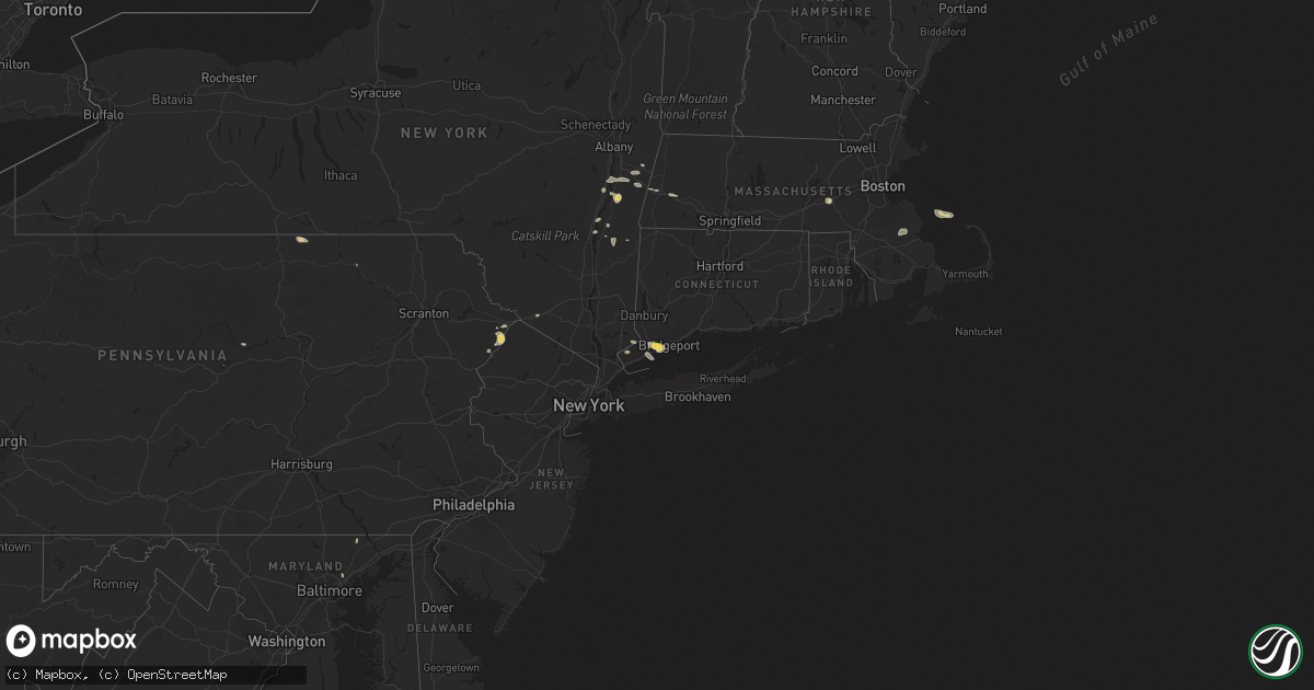
Hail Map on September 6, 2018
Get this storm
September 6 map
$229
one time, instant access
Download today. No call, no setup
Keep the $229
Bought the map and want the full workflow? Apply the entire $229 to a subscription within 7 days. None of it is wasted.
Every map, not just this one
This buys you this map. Subscription and you get every map we run, in the markets you choose from a few cities to whole states to nationwide. Plus real-time alerts the moment a storm fires.
Contact data
Name, contact info, occupancy, even credit band for addresses in the footprint. You go from where it hit to who to call.
Become the source they trust
Unlimited branding weather history reports on demand. You already have the documented answer ready for the property owner, and you are the one who showed up with it.
Property data and RoofTrace estimates
Pull up any address you have got, its value and the exact code rules for that jurisdiction, straight from One Click Code. Then RoofTrace estimates the squares, pitch, and roof value, priced the way you price.
States Impacted by Hail Map on September 6, 2018
Storm reports
Montana
| Date | Description |
|---|---|
| 09/06/20184:30 PM CDT | Mesonet station ekhm8... Elkhorn raws - 8 w townsend. Time of event is estimated. |
Maine
| Date | Description |
|---|---|
| 09/06/201811:46 AM CDT | Pemiquid lighthouse measured wind gust to 69 mph. |
| 09/06/201811:41 AM CDT | Trees and wires down in westport maine. |
| 09/06/201811:40 AM CDT | Quarter size hail. |
| 09/06/201811:35 AM CDT | Numerous trees and power lines down. Between 6 and 8 power poles down on back river road |
| 09/06/201811:30 AM CDT | Trees and wires down on larabees grove road in bath maine. |
| 09/06/201811:30 AM CDT | Lines down in phippsburg maine. |
| 09/06/201811:30 AM CDT | Wires down on washington st in bath maine. |
| 09/06/201811:25 AM CDT | Trees and power lines down |
| 09/06/201811:25 AM CDT | Numerous trees and power lines down |
| 09/06/201811:22 AM CDT | Trees down on cars at courthouse |
| 09/06/201811:17 AM CDT | A local report indicates 58 MPH wind near BRUNSWICK NAVAL AIR STA |
| 09/06/201811:12 AM CDT | Trees and power lines down |
| 09/06/201811:12 AM CDT | Numerous trees and power lines down |
| 09/06/201811:07 AM CDT | Trees and wires down |
| 09/06/201811:07 AM CDT | Trees and power lines down |
| 09/06/201811:02 AM CDT | Large pine down on pope road in windham maine. |
| 09/06/201810:55 AM CDT | Trees and wires downed. |
| 09/06/201810:47 AM CDT | Trees and wires down on granite hill road... Mayberry road. |
| 09/06/201810:42 AM CDT | Trees down on wires on megquire hill rd |
| 09/06/201810:35 AM CDT | Trees and power lines down |
| 09/06/201810:30 AM CDT | Trees and power lines down |
| 09/06/201810:18 AM CDT | Numerous trees and power lines down |
| 09/06/20187:24 AM CDT | At 1223 PM EDT, a two severe thunderstorms located near Georgetown, and Bath, moving east at 40 mph. HAZARD...60 mph wind gusts and quarter size hail. SOURCE...Radar indicated. IMPACT...Hail damage to vehicles is expected. Expect wind damage to roofs, siding, and trees. Locations impacted include... Bath, Wiscasset, Bristol, Georgetown, Bremen, Woolwich, Harpswell, Boothbay, Dresden, Cushing, Edgecomb, Friendship, Arowsic, Monhegan, Westport, Southport, South Bristol, Phippsburg, West Bath and Newcastle.This also includes... Reid State Park and Pemaquid Beach. Burnt Island, Metinic Island, Friendship Long Island, CranberryIsland, and Otter Island. |
| 09/06/20186:40 AM CDT | At 1139 AM EDT, a couple of severe thunderstorms located near Raymond, or near Naples, moving east, southeast at 40 mph. HAZARD...60 mph wind gusts and quarter size hail. SOURCE...Radar indicated. IMPACT...Hail damage to vehicles is expected. Expect wind damage to roofs, siding, and trees. Locations impacted include... Portland, South Portland, Brunswick, Westbrook, Bridgton, Naples, Cumberland, Gorham, Falmouth, Cape Elizabeth, Freeport, Gray, Hiram, Raymond, Yarmouth, Standish, Harpswell, Casco, Brownfield and Denmark.This includes the following highways... Interstate 295 between mile markers 2 and 23. Interstate 95 between mile markers 46 and 68.This also includes... Sebago Lake, Douglas Mountain, and Mount Cutler. Peaks Island, Long Island, Cushing Island, Cousins Island, andBailey Island. |
Mississippi
| Date | Description |
|---|---|
| 09/06/20183:08 PM CDT | Damage to a shed some of tree damage along longvue drive. Possible tornado. |
| 09/06/20187:05 AM CDT | Tree down on south main & sparta road. Likely sub-severe wind gusts. Time estimated based on radar. |
New Hampshire
| Date | Description |
|---|---|
| 09/06/20186:44 AM CDT | At 1144 AM EDT, a severe thunderstorm was located over Bomoseen, moving east at 40 mph. HAZARD...60 mph wind gusts and quarter size hail. SOURCE...Radar indicated. IMPACT...Minor hail damage to vehicles is possible. Expect wind damage to trees and powerlines. Locations impacted include... Woodstock, Rutland, Chester, Castleton, Hartland Four Corners, Cavendish, Killington, Ludlow Village, Rutland City, Perkinsville Village, Mt. Holly, Rutland - Southern Vermont Airport, Plymouth, Hartland, Fair Haven, Clarendon, West Rutland, Ira, West Castleton and Windsor. |
Rhode Island
| Date | Description |
|---|---|
| 09/06/20183:49 PM CDT | Large tree down on pequot ave |
| 09/05/201811:43 PM CDT | At 442 PM EDT, a severe thunderstorm was located over Foxborough, or near Franklin, moving southeast at 50 mph. HAZARD...60 mph wind gusts. SOURCE...Radar indicated. IMPACT...Expect damage to trees and power lines. Locations impacted include... Brockton, Taunton, Cumberland, Franklin, North Attleborough, Stoughton, Bridgewater, Attleboro, Walpole, Mansfield, Middleborough, Easton, Canton, Norton, Sharon, Foxborough, Bellingham, Swansea, East Bridgewater and Raynham. |
Kentucky
| Date | Description |
|---|---|
| 09/06/20186:50 PM CDT | Very large storage buildings composed of metal siding and wood framing were destroyed. |
| 09/06/20182:55 PM CDT | Damage to an outbuilding near albany. |
| 09/06/201812:06 PM CDT | One large tree down on house. |
| 09/06/20183:22 AM CDT | At 821 PM EDT, a severe thunderstorm was located over Greear, or near West Liberty, and is nearly stationary. HAZARD...60 mph wind gusts and quarter size hail. SOURCE...Radar indicated. IMPACT...Hail damage to vehicles is expected. Expect wind damage to roofs, siding, and trees. Locations impacted include... West Liberty, Henry, Woodsbend, Malone, Greear, Gordon Ford, Mize, Licking River, Rexville, Stacy Fork, Index and Pekin. |
| 09/05/20188:29 PM CDT | At 128 PM CDT, a severe thunderstorm was located near Clarksville, moving north at 25 mph. HAZARD...60 mph wind gusts. SOURCE...Radar indicated. IMPACT...Expect damage to roofs, siding, and trees. Locations impacted include... Clarksville.This includes Interstate 24 between mile markers 1 and 16. |
| 09/05/20187:25 PM CDT | Trees down between mile markers 5 and 8 on highway 705. Time estimated off of radar. |
Ohio
| Date | Description |
|---|---|
| 09/06/20182:59 PM CDT | Multiple trees down. Time estimated from radar data. |
| 09/06/20181:42 PM CDT | Wind damage to large tree branches |
| 09/06/20181:38 PM CDT | Trees down along route 658 |
| 09/06/20181:29 PM CDT | Quarter sized hail near n dixie hwy and pennyroyal rd. |
| 09/06/20181:25 PM CDT | Tree down. Time estimated from radar data. |
| 09/06/20181:08 PM CDT | Tree down. Time estimated from radar data. |
| 09/06/201812:51 PM CDT | Tree down. Time estimated from radar data. |
| 09/06/201811:55 AM CDT | Several large tree limbs down on route 16. |
| 09/06/201811:54 AM CDT | Five inch diameter branches downed at partridge rd and partridge ct. Time estimated via radar. |
| 09/06/20187:42 AM CDT | At 1242 PM EDT, a severe thunderstorm was located over Hebron, moving east at 25 mph. HAZARD...60 mph wind gusts. SOURCE...Radar indicated. IMPACT...Expect damage to trees and power lines. Locations impacted include... Newark, Heath, Granville, Buckeye Lake, Hebron, Hanover, Harbor Hills, Granville South, Marne, Fairfield Beach, Thornport, Kirkersville, Gratiot, Toboso, Brownsville, Interstate 70 at State Route 37 and Interstate 70 at State Route 13.This includes I-70 in Ohio between mile markers 123 and 142, and nearmile marker 144. |
| 09/05/201810:59 PM CDT | At 358 PM EDT, a severe thunderstorm was located near Chillicothe, moving east at 20 mph. HAZARD...60 mph wind gusts and quarter size hail. SOURCE...Radar indicated. IMPACT...Minor hail damage to vehicles is possible. Expect wind damage to trees and power lines. Locations impacted include... Chillicothe, Londonderry, Massieville, Mooresville, Scioto Trail State Park and Richmond Dale. |
| 09/05/20189:24 PM CDT | At 223 PM EDT, a severe thunderstorm was located 7 miles south of Coshocton, moving east at 25 mph. HAZARD...Wind gusts to 60 mph and quarter-size hail. SOURCE...Radar. IMPACT...Minor hail damage to vehicles is possible. Expect wind damage to trees and power lines, resulting in some power outages. Locations impacted include... Coshocton... Cambridge... Newcomerstown... West Lafayette... Conesville... Old Washington... Plainfield... Otsego... Boden... Birmingham... Salt Fork State Park... Kimbolton...This includes Interstate 77 in Ohio between mile markers 48 and 66. |
| 09/05/20189:24 PM CDT | At 224 PM EDT, a severe thunderstorm was located over Springboro, moving east at 20 mph. HAZARD...60 mph wind gusts and quarter size hail. SOURCE...Radar indicated. IMPACT...Minor hail damage to vehicles is possible. Expect wind damage to trees and power lines. Locations impacted include... Kettering, Middletown, Miamisburg, Springboro, Franklin, Moraine, Carlisle, West Carrollton, Centerville, Lytle, Pekin, State Route 48 at State Route 73 and Woodbourne-Hyde Park.This includes I-75 in Ohio between mile markers 35 and 46. |
| 09/05/20189:06 PM CDT | At 206 PM EDT, a severe thunderstorm was located over Carlisle, moving east at 15 mph. HAZARD...60 mph wind gusts and nickel size hail. SOURCE...Radar indicated. IMPACT...Expect damage to trees and power lines. Locations impacted include... Kettering, Middletown, Miamisburg, Springboro, Franklin, Moraine, Carlisle, West Carrollton, Germantown and Poast Town Heights.This includes I-75 in Ohio between mile markers 36 and 48. |
| 09/05/20188:20 PM CDT | At 120 PM EDT, a severe thunderstorm was located over West Alexandria, moving east at 15 mph. HAZARD...60 mph wind gusts and quarter size hail. SOURCE...Radar indicated. IMPACT...Minor hail damage to vehicles is possible. Expect wind damage to trees and power lines. Locations impacted include... Trotwood, Eaton, West Alexandria, Gratis, Germantown, New Lebanon, Farmersville, Wheatville and Pyrmont. |
Vermont
| Date | Description |
|---|---|
| 09/06/201811:00 AM CDT | Tree down on avenue d. Manhole covers dislodged by heavy rain runoff. |
| 09/06/20185:36 AM CDT | At 1033 AM EDT, a severe thunderstorm was located over Haverhill, or 20 miles west of Lincoln, moving east at 50 mph. HAZARD...60 mph wind gusts and penny size hail. SOURCE...Radar indicated an intensifying strong thunderstorm near south Newbury, Vt that is expected to become severe shortly with damaging winds in its path. Also other strong storms were developing in this area to the east and may become severe shortly. IMPACT...Expect damage to roofs, siding, and trees. Locations impacted include... Lincoln, Haverhill, Woodstock, Piermont, Bath, Benton, Easton, Ellsworth, Livermore, Waterville Valley, Thornton, Landaff and Hart's Location.This includes Interstate 93 between mile markers 92 and 106. This also includes... Mount Moosilauke, Long Pond Recreation Area, Elbow Pond RecreationArea, South Kinsman Mountain, and Mount Flume. |
North Dakota
| Date | Description |
|---|---|
| 09/06/20186:30 PM CDT | A local report indicates 1.00 inch wind near 4 N RICHARDTON |
| 09/06/20183:50 PM CDT | Report with picture of pea to quarter sized hail covering a deck on social media with time estimated via radar |
| 09/06/20183:50 PM CDT | Mostly pea-sized but a few quarter size hail stones. Heavy rain total was 0.66 inches in just a few minutes. |
| 09/06/20183:30 AM CDT | At 829 PM CDT/729 PM MDT/, a severe thunderstorm was located 5 miles southeast of Glen Ullin, moving east at 20 mph. HAZARD...60 mph wind gusts and quarter size hail. SOURCE...Radar indicated. IMPACT...Hail damage to vehicles is expected. Expect wind damage to roofs, siding, and trees. This severe thunderstorm will be near... Almont around 900 PM CDT. |
| 09/06/20182:24 AM CDT | At 722 PM CDT/622 PM MDT/, a severe thunderstorm was located 5 miles southwest of Hebron, or 13 miles west of Glen Ullin, moving east at 15 mph. HAZARD...Ping pong ball size hail and 60 mph wind gusts. SOURCE...Radar indicated. IMPACT...People and animals outdoors will be injured. Expect hail damage to roofs, siding, windows, and vehicles. Expect wind damage to roofs, siding, and trees. This severe thunderstorm will be near... Hebron around 745 PM CDT. Glen Ullin around 825 PM CDT. |
| 09/06/20181:29 AM CDT | At 628 PM CDT/528 PM MDT/, a severe thunderstorm was located over Richardton, or 21 miles west of Glen Ullin, moving northeast at 10 mph. HAZARD...60 mph wind gusts and quarter size hail. SOURCE...Radar indicated. IMPACT...Hail damage to vehicles is expected. Expect wind damage to roofs, siding, and trees. This severe thunderstorm will be near... Hebron around 610 PM MDT. |
| 09/05/20189:57 PM CDT | At 257 PM CDT, a severe thunderstorm was located near Pleasant Lake, or 47 miles northwest of Devils Lake, moving east at 30 mph. HAZARD...Quarter size hail. SOURCE...Radar indicated. IMPACT...Damage to vehicles is expected. This severe thunderstorm will be near... Knox around 305 PM CDT. York around 320 PM CDT. Leeds around 330 PM CDT. Maza and Cando around 355 PM CDT. |
| 09/05/20189:55 PM CDT | At 254 PM CDT, a severe thunderstorm was located 5 miles north of Rugby, moving east at 30 mph. HAZARD...Quarter size hail. SOURCE...Radar indicated. IMPACT...Damage to vehicles is expected. This severe thunderstorm will be near... Wolford around 325 PM CDT.Other locations impacted by this severe thunderstorm include Nanson. |
| 09/05/20187:40 PM CDT | Lasted about 20 minutes. |
Maryland
| Date | Description |
|---|---|
| 09/06/20186:20 PM CDT | Wires down in the 700 block of churchville road. |
| 09/06/20186:20 PM CDT | Tree on wires and pole down on md-22 in bel air. |
| 09/06/20185:55 PM CDT | Tree down on macton road at the bridge over broad creek. |
| 09/06/20182:42 AM CDT | At 742 PM EDT, a severe thunderstorm was located over Perry Hall, or near Middle River, moving southeast at 10 mph. HAZARD...60 mph wind gusts. SOURCE...Radar indicated. IMPACT...Damaging winds will cause some trees and large branches to fall. This could injure those outdoors, as well as damage homes and vehicles. Roadways may become blocked by downed trees. Localized power outages are possible. Unsecured light objects may become projectiles. Locations impacted include... Middle River, Essex, Carney, Perry Hall, Rossville, White Marsh, Bowleys Quarters, Kingsville, Joppatowne, Nottingham, Glen Arm, Fork, Chase, Bradshaw, Martin State Airport, Upper Falls and Gunpowder. |
| 09/06/20182:08 AM CDT | At 708 PM EDT, a severe thunderstorm was located near Bel Air North, or 9 miles northwest of Aberdeen, moving southeast at 10 mph. HAZARD...60 mph wind gusts. SOURCE...Radar indicated. IMPACT...Damaging winds will cause some trees and large branches to fall. This could injure those outdoors, as well as damage homes and vehicles. Roadways may become blocked by downed trees. Localized power outages are possible. Unsecured light objects may become projectiles. Locations impacted include... Bel Air South, Bel Air North, Darlington, Churchville, Carsins, Scarboro and Hickory. |
| 09/05/201811:15 PM CDT | At 414 PM EDT, a severe thunderstorm was located near Lonaconing, or near Bel Air, and is nearly stationary. HAZARD...60 mph wind gusts. SOURCE...Radar indicated. IMPACT...Damaging winds will cause some trees and large branches to fall. This could injure those outdoors, as well as damage homes and vehicles. Roadways may become blocked by downed trees. Localized power outages are possible. Unsecured light objects may become projectiles. Locations impacted include... Rawlings and Short Gap. |
| 09/05/20187:15 PM CDT | A local report indicates 60 MPH wind near 1 N BALTIMORE MARTIN ST |
| 09/05/20187:15 PM CDT | Tree down into an apartment building on beech drive. |
New York
| Date | Description |
|---|---|
| 09/06/20181:30 PM CDT | Trees down. |
| 09/06/20181:28 PM CDT | Trees and wires down. |
| 09/06/20181:28 PM CDT | Multiple trees and wires down. Road closed. |
| 09/06/20181:25 PM CDT | Trees down. |
| 09/06/20181:25 PM CDT | Trees down. Corrected location. |
| 09/06/20181:19 PM CDT | Tree and wires down. |
| 09/06/20181:18 PM CDT | Tree down on wires along route 9. |
| 09/06/20181:14 PM CDT | Trees and wires down. |
| 09/05/201811:43 PM CDT | At 442 PM EDT, a severe thunderstorm was located near Ridgefield, or near New Canaan, moving east at 15 mph. HAZARD...60 mph wind gusts and quarter size hail. SOURCE...Radar indicated. IMPACT...Minor hail damage to vehicles is possible. Expect wind damage to trees and power lines. This severe thunderstorm will be near... Norwalk around 450 PM EDT. Wilton and Georgetown around 500 PM EDT. Weston around 510 PM EDT. Westport around 515 PM EDT. Fairfield and Trumbull around 530 PM EDT. |
| 09/05/20189:13 PM CDT | At 212 PM EDT, a severe thunderstorm was located over Coxsackie, or near Hudson, moving east at 20 mph. HAZARD...60 mph wind gusts and penny size hail. SOURCE...Radar indicated. IMPACT...Expect damage to roofs, siding, and trees. This severe thunderstorm will be near... Valatie and Claverack-Red Mills around 220 PM EDT. Claverack around 225 PM EDT. Philmont around 230 PM EDT. Chatham around 235 PM EDT.Other locations impacted by this severe thunderstorm includeStuyvesant Falls, Hamburg Light, Chatham Center, Stuyvesant,Columbiaville, Greenport Center, Mellenville, West Coxsackie, Rossmanand Otter Hook. |
| 09/05/20188:46 PM CDT | At 145 PM EDT, a severe thunderstorm was located over Kinderhook, or near Chatham, moving east at 25 mph. HAZARD...60 mph wind gusts and penny size hail. SOURCE...Radar indicated. IMPACT...Expect damage to roofs, siding, and trees. This severe thunderstorm will be near... Valatie around 150 PM EDT. Chatham around 200 PM EDT. Austerlitz around 215 PM EDT.Other locations impacted by this severe thunderstorm include Canaan,Stuyvesant Falls, Chatham Center, Stuyvesant, Columbiaville, Rossman,Rayville, Red Rock, Malden Bridge and Riders Mills. |
Connecticut
| Date | Description |
|---|---|
| 09/06/20184:13 PM CDT | Mulitple trees reported down and snapped...time estimated by radar |
| 09/06/20183:55 PM CDT | Numerous trees reported down on briscoe road |
| 09/06/20183:30 PM CDT | Trees and wires down closing 4 roads including marion ave at sunnyside drive |
| 09/06/20183:20 PM CDT | Tree and wires down on skungamaug road |
| 09/06/20182:34 PM CDT | Tree down on wires. |
| 09/06/20182:25 PM CDT | Tree down on wires. |
| 09/06/20182:14 PM CDT | Tree down on wires. |
| 09/06/201812:22 AM CDT | At 522 PM EDT, a severe thunderstorm was located over Fairfield, or near Bridgeport, moving east at 25 mph. HAZARD...70 mph wind gusts and ping pong ball size hail. SOURCE...Radar indicated. IMPACT...People and animals outdoors will be injured. Expect hail damage to roofs, siding, windows, and vehicles. Expect considerable tree damage. Wind damage is also likely to mobile homes, roofs, and outbuildings. This severe thunderstorm will be near... Bridgeport around 525 PM EDT. |
| 09/05/201810:43 PM CDT | At 343 PM EDT, a severe thunderstorm was located near Litchfield, or 7 miles southwest of Torrington, moving east at 25 mph. HAZARD...60 mph wind gusts and penny size hail. SOURCE...Radar indicated. IMPACT...Expect damage to roofs, siding, and trees. This severe thunderstorm will be near... Litchfield around 355 PM EDT. Thomaston and Northwest Harwinton around 400 PM EDT.Other locations impacted by this severe thunderstorm includeGrappaville, South Kent, Haight Vineyard, Pequabuck, Reynolds Bridge,Kent Furnace, Hancock, Skiff Mountain, Lower Merryall and Warren. |
| 09/05/20189:59 PM CDT | At 259 PM EDT, severe thunderstorms were located along a line extending from near Chester to Otis and Sandisfield in the Berkshires, moving east at 25 mph. HAZARD...60 mph wind gusts and penny size hail. SOURCE...Radar indicated. IMPACT...Expect damage to trees and power lines. Locations impacted include... Springfield, Chicopee, Westfield, Holyoke, Agawam, West Springfield, Simsbury, Ludlow, South Hadley, Easthampton, Suffield, Granby, Canton, Southwick, Southampton, East Granby, Huntington, Hartland, Russell and Westhampton. |
Pennsylvania
| Date | Description |
|---|---|
| 09/06/20183:52 PM CDT | Trees reported down in east hanover township. Confirmed with dauphin county 911 call center. |
| 09/06/20183:38 PM CDT | Trees and large branches down along iams station road from very strong thunderstorm wind |
| 09/06/20183:37 PM CDT | Trees and large branches down around the area of mccullough rd. Wind also ripped a nailed-down tarp off a roof in this area. |
| 09/06/20183:35 PM CDT | Trees and power lines down. |
| 09/06/20183:35 PM CDT | Widespread branches down and power out along andrews rd from very strong thunderstorm wind gusts. |
| 09/06/20183:30 PM CDT | Uprooted and snapped trees photographed along beulah ridge road associated with a downburst |
| 09/05/201811:32 PM CDT | At 432 PM EDT, a severe thunderstorm was located 10 miles northwest of Waynesburg, moving east at 15 mph. HAZARD...Wind gusts to 60 mph and quarter-size hail. SOURCE...Radar. IMPACT...Minor hail damage to vehicles is possible. Expect wind damage to trees and power lines, resulting in some power outages. Locations impacted include... Marianna... Amity...This includes Interstate 79 in Pennsylvania between mile markers 16and 24. |
| 09/05/201811:29 PM CDT | At 428 PM EDT, a severe thunderstorm was located over Dingmans Ferry, or 7 miles southwest of Montague, moving southeast at 10 mph. HAZARD...60 mph wind gusts and nickel size hail. SOURCE...Radar indicated. IMPACT...Damage to roofs, siding, trees, and power lines is possible. Locations impacted include... Branchville, Crandon Lakes and Hainesville. |
| 09/05/201810:23 PM CDT | At 323 PM EDT, a severe thunderstorm was located over West Liberty, moving east at 10 mph. HAZARD...Wind gusts to 60 mph and quarter-size hail. SOURCE...Radar. IMPACT...Minor hail damage to vehicles is possible. Expect wind damage to trees and power lines, resulting in some power outages. Locations impacted include... Wellsburg... West Liberty... Avella... Wolfdale... Bethany... Claysville... Franklin... Hickory... West Alexander... Taylorstown... West Middletown... Green Hills...This includes Interstate 70 in Pennsylvania between mile markers 1and 15. |
| 09/05/20189:46 PM CDT | At 246 PM EDT, a severe thunderstorm was located over Gillett, or 10 miles southwest of Chemung, moving east at 25 mph. HAZARD...60 mph wind gusts and quarter size hail. SOURCE...Radar indicated. IMPACT...Hail damage to vehicles is expected. Expect wind damage to roofs, siding, and trees. This severe thunderstorm will be near... Ridgebury around 255 PM EDT. Springfield around 300 PM EDT. Wetona around 305 PM EDT. East Smithfield around 310 PM EDT. Athens, Ulster and Milan around 315 PM EDT. |
| 09/05/20189:17 PM CDT | At 216 PM EDT, a severe thunderstorm was located over Compton, or near Wyalusing, moving east at 25 mph. HAZARD...60 mph wind gusts and quarter size hail. SOURCE...Radar indicated. IMPACT...Hail damage to vehicles is expected. Expect wind damage to roofs, siding, and trees. This severe thunderstorm will be near... Rushville around 220 PM EDT. Laceyville around 225 PM EDT. Meshoppen and Auburn Center around 240 PM EDT. Springville and Lake Carey around 245 PM EDT. |
| 09/05/20188:40 PM CDT | At 139 PM EDT, a severe thunderstorm was located over Pittston, moving east at 15 mph. HAZARD...60 mph wind gusts and quarter size hail. SOURCE...Radar indicated. IMPACT...Hail damage to vehicles is expected. Expect wind damage to roofs, siding, and trees. This severe thunderstorm will be near... Moosic and Glendale around 155 PM EDT. Dunmore around 210 PM EDT. Elmhurst around 225 PM EDT. Moscow, Lehigh and Gouldsboro around 230 PM EDT. |
Massachusetts
| Date | Description |
|---|---|
| 09/06/20184:10 PM CDT | Large tree branch down on a car on elm street |
| 09/06/20184:00 PM CDT | Multiple wires down scattered on norfolk street |
| 09/06/20184:00 PM CDT | Tree down on wires on north street |
| 09/06/20183:59 PM CDT | Tree down on school street |
| 09/06/20183:44 PM CDT | Tree branch down on wires on water row at plympton sreet |
| 09/06/20183:41 PM CDT | Large tree down on lovering street |
| 09/06/20183:40 PM CDT | Wires and tree down on fuller place |
| 09/06/20183:34 PM CDT | Tree down on hiler street in the rolling meadow area |
| 09/06/20183:33 PM CDT | Tree down blocking road on high street |
| 09/06/20183:25 PM CDT | Tree down on north washington street |
| 09/06/20183:25 PM CDT | Tree down on rocky pond road |
| 09/06/20183:25 PM CDT | Trees down on princeton road... Chamberlin road... And campground road |
| 09/06/20182:55 PM CDT | Tree down on princeton road |
| 09/06/20182:37 PM CDT | Large tree down on browning pond road at the oakham line |
| 09/06/20182:35 PM CDT | Trees and wires down on alpine road |
| 09/06/20182:35 PM CDT | Tree and wires down between williams and laurel road |
| 09/06/20182:25 PM CDT | 3 trees down blocking north lane |
| 09/06/20182:20 PM CDT | Tree and wires down on a trcuk on hardwick road at mechanic street. |
| 09/06/20181:53 PM CDT | Road blocked by downed tree and wires down. |
| 09/06/20181:43 PM CDT | Tree and wires down on a house. |
| 09/06/20181:17 PM CDT | Tree down on wires. |
| 09/06/20181:17 PM CDT | Large tree down with wires blocking road. |
| 09/06/20181:17 PM CDT | Tree down on wires. |
| 09/05/201811:51 PM CDT | At 451 PM EDT, a severe thunderstorm was located over the coastal waters 8 miles northwest of Provincetown, moving east at 30 mph. HAZARD...60 mph wind gusts and quarter size hail. SOURCE...Radar indicated. IMPACT...Hail damage to vehicles is possible. Expect damage to trees and power lines. Locations impacted include... Provincetown, Wellfleet and Truro. |
| 09/05/201811:23 PM CDT | At 422 PM EDT, a severe thunderstorm was located over Hopkinton, or near Milford, moving east at 45 mph. HAZARD...60 mph wind gusts and quarter size hail. SOURCE...Radar indicated. IMPACT...Hail damage to vehicles is possible. Expect damage to trees and power lines. Locations impacted include... Boston, Cambridge, Quincy, Lynn, Newton, Somerville, Framingham, Waltham, Malden, Brookline, Medford, Weymouth, Revere, Arlington, Everett, Salem, Marlborough, Braintree, Chelsea and Natick. |
| 09/05/20189:58 PM CDT | At 257 PM EDT, a severe thunderstorm was located over Pine Plains, or 13 miles east of Rhinebeck, moving east at 25 mph. HAZARD...70 mph wind gusts and penny size hail. SOURCE...Radar indicated. IMPACT...Expect considerable tree damage. Damage is likely to mobile homes, roofs, and outbuildings. This severe thunderstorm will be near... Amenia and Millerton around 310 PM EDT. Sharon around 320 PM EDT. Falls Village around 330 PM EDT. Canaan around 335 PM EDT. Norfolk around 350 PM EDT. Torrington around 355 PM EDT. Winsted around 400 PM EDT.Other locations impacted by this severe thunderstorm includeCornwall, West Torrington, Ancramdale, South Canaan, Lithgow,Wrightville, Salisbury, Smithfield, South Amenia and Taconic. |
| 09/05/20189:36 PM CDT | At 236 PM EDT, a severe thunderstorm was located near Great Barrington, moving east at 25 mph. HAZARD...60 mph wind gusts and penny size hail. SOURCE...Radar indicated. IMPACT...Expect damage to roofs, siding, and trees. This severe thunderstorm will be near... Great Barrington and Housatonic around 240 PM EDT. Sheffield around 245 PM EDT. Ashley Falls around 250 PM EDT. Otis and Sandisfield around 315 PM EDT.Other locations impacted by this severe thunderstorm includeHartsville, Konkapot, Gomorrah, New Boston, Alford, Newsboy Statue,Montville, North Hillsdale, Alander and Southfield. |
| 09/05/20189:18 PM CDT | At 218 PM EDT, a severe thunderstorm was located over Clermont, or 7 miles east of Saugerties, moving east at 25 mph. HAZARD...60 mph wind gusts and penny size hail. SOURCE...Radar indicated. IMPACT...Expect damage to roofs, siding, and trees. This severe thunderstorm will be near... Pine Plains and Ancram around 240 PM EDT. Copake around 250 PM EDT. Millerton around 300 PM EDT.Other locations impacted by this severe thunderstorm include PachinMills, Ancramdale, Kerleys Corners, Burden Dock, Burden, Churchtown,Linden Acres, Linlithgo Mills, Nevis and Fraleighs. |
| 09/05/20189:06 PM CDT | At 206 PM EDT, a severe thunderstorm was located near Austerlitz, or 9 miles east of Chatham, moving east at 30 mph. HAZARD...60 mph wind gusts and penny size hail. SOURCE...Radar indicated. IMPACT...Expect damage to roofs, siding, and trees. This severe thunderstorm will be near... Lenox around 220 PM EDT. Lee around 225 PM EDT. Pittsfield around 230 PM EDT. Becket around 245 PM EDT.Other locations impacted by this severe thunderstorm includeBarkerville, Glendale, Williamsville, Lenox Dale, The Center AtLenox, Stearnsville, Carey Corner, West Pittsfield, West StockbridgeCenter and Leisure Lee. |
West Virginia
| Date | Description |
|---|---|
| 09/06/20184:30 PM CDT | A few trees down on patterson creek road near the mineral county line. |
| 09/06/20183:40 PM CDT | Tree down near the intersection of cut off road and new creek highway. |
| 09/06/20183:35 PM CDT | Three large trees down including one into a barn and multiple large limbs down near the 4400 block of knobley road in short gap. |
| 09/06/20182:41 PM CDT | Trees down |
| 09/06/20182:34 PM CDT | Branches down between bethany and west liberty. |
| 09/05/201811:29 PM CDT | At 429 PM EDT, a severe thunderstorm was located 8 miles northeast of Cameron, or 10 miles southeast of Triadelphia, moving east at 15 mph. HAZARD...Wind gusts to 60 mph and quarter-size hail. SOURCE...Radar. IMPACT...Minor hail damage to vehicles is possible. Expect wind damage to trees and power lines, resulting in some power outages. Locations impacted include... Rogersville... |
| 09/05/201810:42 PM CDT | At 342 PM EDT, a severe thunderstorm was located near Mannington, moving east at 10 mph. HAZARD...Wind gusts to 60 mph and quarter-size hail. SOURCE...Radar. IMPACT...Minor hail damage to vehicles is possible. Expect wind damage to trees and power lines, resulting in some power outages. Locations impacted include... Fairmont... Mannington... Barrackville... Monongah... Farmington... Worthington... Grangeville... Rachel... Carolina... Idamay... White Hall... |
Cities Impacted by Hail Map on September 6, 2018
- Yazoo City, MS
- Silver City, MS
- Hebron, ND
- Glen Ullin, ND
- Richardton, ND
- Churchs Ferry, ND
- Devils Lake, ND
- Beulah, ND
- Zap, ND
- Auburn, KY
- Russellville, KY
- Topsham, ME
- Ezel, KY
- West Liberty, KY
- Mize, KY
- Carbondale, IL
- Murphysboro, IL
- Makanda, IL
- Nashville, TN
- Ashland City, TN
- Linden, TN
- Howard, PA
- Morganfield, KY
- Clay, KY
- Oberlin, LA
- Hudson, NY
- Ghent, NY
- Chillicothe, OH
- Frenchburg, KY
- Stanton, KY
- Means, KY
- Burns, TN
- Dickson, TN
- McKee, KY
- Marion, IL
- Wolford, ND
- Bowling Green, KY
- Pioneer, TN
- La Follette, TN
- Deridder, LA
- Dingmans Ferry, PA
- Ferdinand, IN
- Clay City, KY
- Germantown, OH
- Taylor, ND
- West Stockbridge, MA
- Stockbridge, MA
- Hanson, KY
- Manitou, KY
- Stottville, NY
- Athens, NY
- Oakland, KY
- Scottsville, KY
- Smiths Grove, KY
- Cando, ND
- Martin, TN
- South Fulton, TN
- Englewood, TN
- Leeds, ND
- York, ND
- Towner, ND
- Willow City, ND
- Franklin, TN
- Eaton, OH
- West Alexandria, OH
- Tellico Plains, TN
- Westport, CT
- Southport, CT
- Norwalk, CT
- Wilton, CT
- Weston, CT
- Fairfield, CT
- Cannelton, IN
- Tell City, IN
- Rugby, ND
- Waverly, OH
- Walpole, ME
- South Bristol, ME
- Wiscasset, ME
- Trevett, ME
- Woolwich, ME
- Boothbay, ME
- Liberty, KY
- Nolensville, TN
- Brentwood, TN
- Antioch, TN
- Corydon, KY
- Dixon, KY
- Sebree, KY
- Cutler, IL
- Percy, IL
- Ava, IL
- Becket, MA
- Lee, MA
- Franklin, KY
- Cedar Grove, TN
- Slaughters, KY
- Rolette, ND
- Knox, ND
- Charlotte, TN
- Gillett, PA
- Millerton, PA
- Pegram, TN
- Pemaquid, ME
- Bristol, ME
- Edgecomb, ME
- Bath, ME
- Danville, WV
- Julian, WV
- Ridgeview, WV
- Foster, WV
- Stamford, CT
- Greenwich, CT
- Rockfield, KY
- Layton, NJ
- Durham, ME
- Altenburg, MO
- Jackson, MO
- Jeffersonville, KY
- Mylo, ND
- Bisbee, ND
- Starkweather, ND
- Red Hook, NY
- Stanfordville, NY
- Clinton Corners, NY
- Melber, KY
- Milford, PA
- Franklin, OH
- Middletown, OH
- Miamisburg, OH
- Farmersville, OH
- Perry Hall, MD
- Parkville, MD
- Nottingham, MD
- Singer, LA
- New Leipzig, ND
- Darlington, PA
- Henderson, KY
- Nellis, WV
- Madison, WV
- Costa, WV
- White Bluff, TN
- Saugerties, NY
- Barrytown, NY
- Joelton, TN
- Albany, KY
- Negley, OH
- East Palestine, OH
- Rogers, OH
- East Nassau, NY
- Williamsburg, KY
- Crary, ND
- Etowah, TN
- Webster, ND
- Brunswick, ME
- Wysox, PA
- Steeleville, IL
- Campbell Hill, IL
- Mittie, LA
- Dry Creek, LA
- Kinder, LA
- Lakota, ND
- Westborough, MA
- Hopkinton, MA
- Flemingsburg, KY
- New Palestine, IN
- Greenfield, IN
- Fountaintown, IN
- Duff, TN
- Street, MD
- Coxsackie, NY
- Wolf Lake, IL
- Alto Pass, IL
- Pomona, IL
- Jonesboro, IL
- Cape Girardeau, MO
- New Harbor, ME
- Chamberlain, ME
- Elizaville, NY
- Tivoli, NY
- Germantown, NY
- Middletown, NY
- Slate Hill, NY
- Old Appleton, MO
- De Soto, IL
- Frohna, MO
- Grand Tower, IL
- Oak Ridge, MO
- Cobden, IL
- Uniontown, MO
- Vergennes, IL
- Gorham, IL
- Pleasant View, TN
- Chester, IL
- Rockwood, IL
- Perryville, MO
- Pound Ridge, NY
- New Canaan, CT
- Wickliffe, KY
- Barlow, KY
- Pembroke, MA
- Hanson, MA
- Halifax, MA
- Auburn, ME
- Lisbon, ME
- New Gloucester, ME
- Lock Haven, PA
- Kevil, KY
- Brookport, IL
- Paducah, KY
- West Paducah, KY
- Valley Grove, WV
- Bethany, WV
- Irvine, KY
- Beattyville, KY
- Lewisburg, KY
- Morgantown, KY
- East Chatham, NY
- Old Chatham, NY
- Brainard, NY
- Manchester, KY
- Boonville, IN
- Malden On Hudson, NY
- Salt Lick, KY
- Olympia, KY
- Glasgow, KY
- Austerlitz, NY
- Chatham, NY
- Waynesville, OH
- Lebanon, OH
- Tamiment, PA
- Bushkill, PA
- Hazel Green, KY
- Halls, TN
- Pine Plains, NY
- Gandeeville, WV
- Round Pond, ME
- Bowdoinham, ME
- Columbia, NJ
- Montague, NJ
- Minnewaukan, ND
- Beaver Falls, PA
- New Brighton, PA
- Brownsville, KY
- Wildersville, TN
- Lexington, TN
- Alvaton, KY
- Merryville, LA
- Longville, LA
- Richland, IN
- West Coxsackie, NY
- Valatie, NY
- Kinderhook, NY
- Stuyvesant, NY
- Schodack Landing, NY