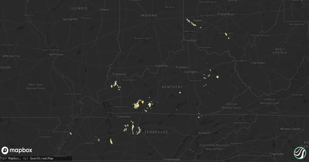
Hail Map in Kentucky on September 6, 2018
Get this storm
September 6 map
$229
one time, instant access
Download today. No call, no setup
Keep the $229
Bought the map and want the full workflow? Apply the entire $229 to a subscription within 7 days. None of it is wasted.
Every map, not just this one
This buys you this map. Subscription and you get every map we run, in the markets you choose from a few cities to whole states to nationwide. Plus real-time alerts the moment a storm fires.
Contact data
Name, contact info, occupancy, even credit band for addresses in the footprint. You go from where it hit to who to call.
Become the source they trust
Unlimited branding weather history reports on demand. You already have the documented answer ready for the property owner, and you are the one who showed up with it.
Property data and RoofTrace estimates
Pull up any address you have got, its value and the exact code rules for that jurisdiction, straight from One Click Code. Then RoofTrace estimates the squares, pitch, and roof value, priced the way you price.
Storm reports in Kentucky
Kentucky
| Date | Description |
|---|---|
| 09/06/20186:50 PM CDT | Very large storage buildings composed of metal siding and wood framing were destroyed. |
| 09/06/20182:55 PM CDT | Damage to an outbuilding near albany. |
| 09/06/201812:06 PM CDT | One large tree down on house. |
| 09/06/20183:22 AM CDT | At 821 PM EDT, a severe thunderstorm was located over Greear, or near West Liberty, and is nearly stationary. HAZARD...60 mph wind gusts and quarter size hail. SOURCE...Radar indicated. IMPACT...Hail damage to vehicles is expected. Expect wind damage to roofs, siding, and trees. Locations impacted include... West Liberty, Henry, Woodsbend, Malone, Greear, Gordon Ford, Mize, Licking River, Rexville, Stacy Fork, Index and Pekin. |
| 09/05/20188:29 PM CDT | At 128 PM CDT, a severe thunderstorm was located near Clarksville, moving north at 25 mph. HAZARD...60 mph wind gusts. SOURCE...Radar indicated. IMPACT...Expect damage to roofs, siding, and trees. Locations impacted include... Clarksville.This includes Interstate 24 between mile markers 1 and 16. |
| 09/05/20187:25 PM CDT | Trees down between mile markers 5 and 8 on highway 705. Time estimated off of radar. |
All States Impacted by Hail Map on September 6, 2018
Cities Impacted by Hail Map on September 6, 2018
- Yazoo City, MS
- Silver City, MS
- Hebron, ND
- Glen Ullin, ND
- Richardton, ND
- Churchs Ferry, ND
- Devils Lake, ND
- Beulah, ND
- Zap, ND
- Auburn, KY
- Russellville, KY
- Topsham, ME
- Ezel, KY
- West Liberty, KY
- Mize, KY
- Carbondale, IL
- Murphysboro, IL
- Makanda, IL
- Nashville, TN
- Ashland City, TN
- Linden, TN
- Howard, PA
- Morganfield, KY
- Clay, KY
- Oberlin, LA
- Hudson, NY
- Ghent, NY
- Chillicothe, OH
- Frenchburg, KY
- Stanton, KY
- Means, KY
- Burns, TN
- Dickson, TN
- McKee, KY
- Marion, IL
- Wolford, ND
- Bowling Green, KY
- Pioneer, TN
- La Follette, TN
- Deridder, LA
- Dingmans Ferry, PA
- Ferdinand, IN
- Clay City, KY
- Germantown, OH
- Taylor, ND
- West Stockbridge, MA
- Stockbridge, MA
- Hanson, KY
- Manitou, KY
- Stottville, NY
- Athens, NY
- Oakland, KY
- Scottsville, KY
- Smiths Grove, KY
- Cando, ND
- Martin, TN
- South Fulton, TN
- Englewood, TN
- Leeds, ND
- York, ND
- Towner, ND
- Willow City, ND
- Franklin, TN
- Eaton, OH
- West Alexandria, OH
- Tellico Plains, TN
- Westport, CT
- Southport, CT
- Norwalk, CT
- Wilton, CT
- Weston, CT
- Fairfield, CT
- Cannelton, IN
- Tell City, IN
- Rugby, ND
- Waverly, OH
- Walpole, ME
- South Bristol, ME
- Wiscasset, ME
- Trevett, ME
- Woolwich, ME
- Boothbay, ME
- Liberty, KY
- Nolensville, TN
- Brentwood, TN
- Antioch, TN
- Corydon, KY
- Dixon, KY
- Sebree, KY
- Cutler, IL
- Percy, IL
- Ava, IL
- Becket, MA
- Lee, MA
- Franklin, KY
- Cedar Grove, TN
- Slaughters, KY
- Rolette, ND
- Knox, ND
- Charlotte, TN
- Gillett, PA
- Millerton, PA
- Pegram, TN
- Pemaquid, ME
- Bristol, ME
- Edgecomb, ME
- Bath, ME
- Danville, WV
- Julian, WV
- Ridgeview, WV
- Foster, WV
- Stamford, CT
- Greenwich, CT
- Rockfield, KY
- Layton, NJ
- Durham, ME
- Altenburg, MO
- Jackson, MO
- Jeffersonville, KY
- Mylo, ND
- Bisbee, ND
- Starkweather, ND
- Red Hook, NY
- Stanfordville, NY
- Clinton Corners, NY
- Melber, KY
- Milford, PA
- Franklin, OH
- Middletown, OH
- Miamisburg, OH
- Farmersville, OH
- Perry Hall, MD
- Parkville, MD
- Nottingham, MD
- Singer, LA
- New Leipzig, ND
- Darlington, PA
- Henderson, KY
- Nellis, WV
- Madison, WV
- Costa, WV
- White Bluff, TN
- Saugerties, NY
- Barrytown, NY
- Joelton, TN
- Albany, KY
- Negley, OH
- East Palestine, OH
- Rogers, OH
- East Nassau, NY
- Williamsburg, KY
- Crary, ND
- Etowah, TN
- Webster, ND
- Brunswick, ME
- Wysox, PA
- Steeleville, IL
- Campbell Hill, IL
- Mittie, LA
- Dry Creek, LA
- Kinder, LA
- Lakota, ND
- Westborough, MA
- Hopkinton, MA
- Flemingsburg, KY
- New Palestine, IN
- Greenfield, IN
- Fountaintown, IN
- Duff, TN
- Street, MD
- Coxsackie, NY
- Wolf Lake, IL
- Alto Pass, IL
- Pomona, IL
- Jonesboro, IL
- Cape Girardeau, MO
- New Harbor, ME
- Chamberlain, ME
- Elizaville, NY
- Tivoli, NY
- Germantown, NY
- Middletown, NY
- Slate Hill, NY
- Old Appleton, MO
- De Soto, IL
- Frohna, MO
- Grand Tower, IL
- Oak Ridge, MO
- Cobden, IL
- Uniontown, MO
- Vergennes, IL
- Gorham, IL
- Pleasant View, TN
- Chester, IL
- Rockwood, IL
- Perryville, MO
- Pound Ridge, NY
- New Canaan, CT
- Wickliffe, KY
- Barlow, KY
- Pembroke, MA
- Hanson, MA
- Halifax, MA
- Auburn, ME
- Lisbon, ME
- New Gloucester, ME
- Lock Haven, PA
- Kevil, KY
- Brookport, IL
- Paducah, KY
- West Paducah, KY
- Valley Grove, WV
- Bethany, WV
- Irvine, KY
- Beattyville, KY
- Lewisburg, KY
- Morgantown, KY
- East Chatham, NY
- Old Chatham, NY
- Brainard, NY
- Manchester, KY
- Boonville, IN
- Malden On Hudson, NY
- Salt Lick, KY
- Olympia, KY
- Glasgow, KY
- Austerlitz, NY
- Chatham, NY
- Waynesville, OH
- Lebanon, OH
- Tamiment, PA
- Bushkill, PA
- Hazel Green, KY
- Halls, TN
- Pine Plains, NY
- Gandeeville, WV
- Round Pond, ME
- Bowdoinham, ME
- Columbia, NJ
- Montague, NJ
- Minnewaukan, ND
- Beaver Falls, PA
- New Brighton, PA
- Brownsville, KY
- Wildersville, TN
- Lexington, TN
- Alvaton, KY
- Merryville, LA
- Longville, LA
- Richland, IN
- West Coxsackie, NY
- Valatie, NY
- Kinderhook, NY
- Stuyvesant, NY
- Schodack Landing, NY


