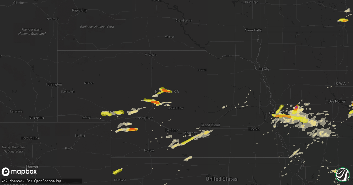
Hail Map in Nebraska on August 31, 2018
Get this storm
August 31 map
$229
one time, instant access
Download today. No call, no setup
Keep the $229
Bought the map and want the full workflow? Apply the entire $229 to a subscription within 7 days. None of it is wasted.
Every map, not just this one
This buys you this map. Subscription and you get every map we run, in the markets you choose from a few cities to whole states to nationwide. Plus real-time alerts the moment a storm fires.
Contact data
Name, contact info, occupancy, even credit band for addresses in the footprint. You go from where it hit to who to call.
Become the source they trust
Unlimited branding weather history reports on demand. You already have the documented answer ready for the property owner, and you are the one who showed up with it.
Property data and RoofTrace estimates
Pull up any address you have got, its value and the exact code rules for that jurisdiction, straight from One Click Code. Then RoofTrace estimates the squares, pitch, and roof value, priced the way you price.
Storm reports in Nebraska
Nebraska
| Date | Description |
|---|---|
| 08/31/20186:49 PM CDT | A local report indicates 1.75 inch wind near 7 ENE STAPLETON |
| 08/31/20185:58 PM CDT | A local report indicates 1.00 inch wind near 5 NW DUNNING |
| 08/31/20184:55 PM CDT | Report via social media |
| 08/31/20184:17 PM CDT | Report via social media with pictures. |
| 08/31/20189:00 AM CDT | Public report with pictures on facebook. Time estimated from radar. |
| 08/31/20187:26 AM CDT | At 1226 AM CDT, a severe thunderstorm was located near Powhattan, moving northeast at 20 mph. HAZARD...60 mph wind gusts and quarter size hail. SOURCE...Radar indicated. IMPACT...Hail damage to vehicles is expected. Expect wind damage to roofs, siding, and trees. Locations impacted include... Hiawatha, Fairview, Robinson, Reserve, Powhattan and Hamlin. |
| 08/31/20185:13 AM CDT | At 1013 PM CDT, a severe thunderstorm was located near Wallace, or 20 miles north of Hayes Center, moving east at 30 mph. HAZARD...Ping pong ball size hail and 60 mph wind gusts. SOURCE...Radar indicated. IMPACT...People and animals outdoors will be injured. Expect hail damage to roofs, siding, windows, and vehicles. Expect wind damage to roofs, siding, and trees. Locations impacted include... Wallace, Dickens and Somerset. |
| 08/31/20183:51 AM CDT | At 851 PM CDT, a severe thunderstorm was located 10 miles north of Sutherland, or 20 miles southwest of Tryon, moving northeast at 25 mph. HAZARD...60 mph wind gusts and quarter size hail. SOURCE...Radar indicated. IMPACT...Hail damage to vehicles is expected. Expect wind damage to roofs, siding, and trees. This severe thunderstorm will remain over mainly rural areas of northwestern Lincoln and south central McPherson Counties.This includes the following highways... Highway 92 between mile markers 198 and 204. Highway 97 between mile markers 9 and 19, and near mile marker 32. |
| 08/31/20182:26 AM CDT | Large tree limbs/branches down in the city. Pictures from facebook. Time estimated from radar. |
| 08/31/20182:23 AM CDT | Pictures from facebook show very large tree limbs down on top of vehicles and a home. No damage known to home or vehicle. Time estimated from radar. |
| 08/31/20182:03 AM CDT | A local report indicates 58 MPH wind near GRAND ISLAND AIRPORT |
| 08/31/20181:54 AM CDT | At 653 PM MDT, a severe thunderstorm was located over Lemoyne, or 10 miles north of Ogallala, moving east at 20 mph. HAZARD...60 mph wind gusts and quarter size hail. SOURCE...Radar indicated. IMPACT...Hail damage to vehicles is expected. Expect wind damage to roofs, siding, and trees. Locations impacted include... Lemoyne, Keystone, Kingsley Dam, Big Bald Hill, Bucktail Lake, Broganville and Lake View Campground.This includes the following highways... Highway 61 between mile markers 94 and 111. Highway 92 between mile markers 128 and 138. |
| 08/31/20181:50 AM CDT | Large diameter limb... Upwards to a foot... Down. Estimated 60-70 mph winds. Noted tree damage not widespread... But it is noticeable around town. |
| 08/31/20181:41 AM CDT | At 641 PM CDT, a severe thunderstorm was located 7 miles northeast of Gandy, or 10 miles northeast of Stapleton, moving east at 20 mph. HAZARD...60 mph wind gusts and quarter size hail. SOURCE...Radar indicated. IMPACT...Hail damage to vehicles is expected. Expect wind damage to roofs, siding, and trees. Locations impacted include... Arnold, Logan, Tarboz Lake, Shanklin Bluff, Pleasant Hill, Hoagland and Finchville.This includes Highway 92 between mile markers 243 and 260. |
| 08/31/20181:34 AM CDT | A local report indicates 60 MPH wind near HASTINGS AIRPORT |
| 08/31/20181:33 AM CDT | A local report indicates 69 MPH wind near 2 NNE NORMAN |
| 08/31/201812:59 AM CDT | At 559 PM MDT, a severe thunderstorm was located near Lewellen, or 10 miles southeast of Oshkosh, moving east at 15 mph. HAZARD...60 mph wind gusts and quarter size hail. SOURCE...Radar indicated. IMPACT...Hail damage to vehicles is expected. Expect wind damage to roofs, siding, and trees. Locations impacted include... Lewellen, Ash Hollow State Historical Park, Eagle Gulch Campground, Ruthon, Belmar, Clear Creek State Wildlife Management Area, Bluewater Battlefield State Historical Park, Otter Creek Campground, Windlass Hill and Lake View Campground.This includes Highway 92 between mile markers 115 and 129. |
| 08/31/201812:47 AM CDT | At 546 PM CDT, a severe thunderstorm was located near Halsey, or 18 miles southeast of Thedford, moving northeast at 25 mph. HAZARD...Quarter size hail. SOURCE...Radar indicated. IMPACT...Damage to vehicles is expected. Locations impacted include... Dunning and Hawley Flats. This includes Highway 2 between mile markers 228 and 240. |
| 08/31/201812:37 AM CDT | Delayed report: hail ranged from pea to quarter size. Time est fm radar. |
| 08/30/201811:54 PM CDT | At 453 PM CDT, a severe thunderstorm was located near Ringgold, or 12 miles northwest of Stapleton, moving southeast at 15 mph. HAZARD...Quarter size hail. SOURCE...Radar indicated. IMPACT...Damage to vehicles is expected. Locations impacted include... Stapleton and Gandy. This includes the following highways... Highway 92 between mile markers 224 and 234. Highway 83 between mile markers 108 and 123. |
| 08/30/201810:15 PM CDT | Thunderstorm wind gust estimated at 60 mph droped a large tree limb on a house. |
| 08/30/20188:49 PM CDT | At 149 AM CDT, a severe thunderstorm was located near White Cloud, or near Highland, moving northeast at 20 mph. HAZARD...Ping pong ball size hail. SOURCE...Radar indicated. IMPACT...People and animals outdoors will be injured. Expect damage to roofs, siding, windows, and vehicles. Locations impacted include... Highland, White Cloud and Iowa Point. |
| 08/30/20188:26 PM CDT | At 126 AM CDT, a severe thunderstorm was located 5 miles north of Robinson, moving northeast at 25 mph. HAZARD...Ping pong ball size hail and 60 mph wind gusts. SOURCE...Radar indicated. IMPACT...People and animals outdoors will be injured. Expect hail damage to roofs, siding, windows, and vehicles. Expect wind damage to roofs, siding, and trees. Locations impacted include... Robinson. |
| 08/30/20188:03 PM CDT | Mostly dime size but up to quarter size hail. |
| 08/30/20188:03 PM CDT | A local report indicates 60 MPH wind near 5 E LEMOYNE |
| 08/30/20187:01 PM CDT | A local report indicates 1.00 inch wind near 5 SW LEWELLEN |
All States Impacted by Hail Map on August 31, 2018
Cities Impacted by Hail Map on August 31, 2018
- Kearney, NE
- Anita, IA
- Adair, IA
- Exira, IA
- Glenwood, IA
- Pacific Junction, IA
- Sutherland, NE
- Hershey, NE
- Holden, MO
- Harrisonville, MO
- Creighton, MO
- Garden City, MO
- Pelkie, MI
- Lanse, MI
- Wallace, NE
- Elsie, NE
- Madrid, NE
- Owatonna, MN
- Cloquet, MN
- Fairmount, ND
- Emerson, IA
- Imogene, IA
- Randolph, IA
- Malvern, IA
- Hastings, IA
- Ferrum, VA
- Council Bluffs, IA
- Grant, NE
- Venango, NE
- Clifton, AZ
- Halsey, NE
- Mount Ayr, IA
- Brock, NE
- Talmage, NE
- Martinsville, MO
- Braymer, MO
- Ludlow, MO
- Dawn, MO
- New Sharon, IA
- What Cheer, IA
- Rose Hill, IA
- Oskaloosa, IA
- Mayodan, NC
- Holton, KS
- Kellerton, IA
- Lamoni, IA
- Underwood, MN
- Arnold, NE
- Fairfax, MO
- Centerview, MO
- Odessa, MO
- Montezuma, IA
- Searsboro, IA
- Hartwick, IA
- Brooklyn, IA
- Malcom, IA
- Grinnell, IA
- Wadena, MN
- Deer Creek, MN
- Virginia Beach, VA
- Chesapeake, VA
- Concordia, MO
- Park, KS
- Axtell, NE
- Edison, NE
- Oxford, NE
- Minden, NE
- Atlanta, NE
- Bertrand, NE
- Funk, NE
- Holdrege, NE
- Heartwell, NE
- Kenesaw, NE
- Wood River, NE
- Henning, MN
- Clitherall, MN
- Vining, MN
- Fergus Falls, MN
- Battle Lake, MN
- Lucama, NC
- Wilson, NC
- Ellsworth, WI
- Fort Mill, SC
- Rock Hill, SC
- Papillion, NE
- Rush Center, KS
- Fisher, MN
- La Pointe, WI
- Gladbrook, IA
- Canyon, MN
- Alborn, MN
- Saginaw, MN
- Brookston, MN
- Peru, IA
- Campbellsburg, IN
- Crosslake, MN
- Pequot Lakes, MN
- Pine River, MN
- Nisswa, MN
- Otoe, NE
- Nebraska City, NE
- Lawson, MO
- Lathrop, MO
- Holt, MO
- Badger, MN
- Roseau, MN
- Bayfield, WI
- Cornucopia, WI
- San Carlos, AZ
- Brewster, NE
- Purdum, NE
- Higginsville, MO
- Corder, MO
- Gothenburg, NE
- Dickens, NE
- Cumberland, IA
- Griswold, IA
- Masonville, IA
- Coggon, IA
- Urbana, IA
- Rowley, IA
- Vinton, IA
- Winthrop, IA
- Center Point, IA
- Walker, IA
- Bloomfield, KY
- Knoxville, IA
- Corning, IA
- Villisca, IA
- Oshkosh, NE
- Chappell, NE
- Big Springs, NE
- Lewellen, NE
- White Pine, MI
- Wakefield, MI
- Bessemer, MI
- Ontonagon, MI
- Montour, IA
- Tama, IA
- Aurora, NC
- Scott City, KS
- Wiota, IA
- Edgewood, IA
- Toledo, IA
- Marne, IA
- Atlantic, IA
- Underwood, IA
- Crescent, IA
- Hager City, WI
- Marienthal, KS
- Cowgill, MO
- Floodwood, MN
- Wright, MN
- Sigourney, IA
- Stapleton, NE
- Arapahoe, NE
- Macedonia, IA
- Carbon, IA
- Lenox, IA
- Cromwell, IA
- Treynor, IA
- Oakland, IA
- Walnut, IA
- Grant, IA
- Massena, IA
- Bellevue, NE
- Red Oak, IA
- Stanton, IA
- Elliott, IA
- Silver City, IA
- Lewis, IA
- Henderson, IA
- Carson, IA
- Omaha, NE
- Diagonal, IA
- Prescott, IA
- Nodaway, IA
- Creston, IA
- Esko, MN
- Hancock, MI
- Aitkin, MN
- Tintah, MN
- Inverness, FL
- Chassell, MI
- Lake Linden, MI
- Harvey, IA
- Pella, IA
- Collyer, KS
- Quinter, KS
- Cromwell, MN
- Agra, KS
- Tryon, NE
- Stockville, NE
- Stuart, VA
- Woolwine, VA
- Hankinson, ND
- Crosby, MN
- Merrifield, MN
- Gonvick, MN
- Madison, NC
- Greenwood, DE
- Houston, DE
- Lincoln, DE
- Milford, DE
- Grinnell, KS
- Oakley, KS
- Gove, KS
- Leoti, KS
- Watersmeet, MI
- Eldridge, IA
- Bettendorf, IA
- Princeton, IA
- Davenport, IA
- Le Claire, IA
- Anselmo, NE
- Merna, NE
- Traer, IA
- Brayton, IA
- Lakin, KS
- Ulysses, KS
- Tracy, IA
- Meade, KS
- Afton, IA
- Warrensburg, MO
- West Point, NE
- Dodge, NE
- Weldon, IA
- Osceola, IA
- Eckerman, MI
- Essex, IA
- Meadowlands, MN
- Ramah, NM
- Carrollton, MO
- Norborne, MO
- Max Meadows, VA
- Campbell, MN
- Wahpeton, ND
- Hancock, IA
- Walsh, CO
- Bogard, MO
- Grants, NM
- Duluth, MN
- Palmyra, NE
- Unadilla, NE
- Pleasant Hill, MO
- Adams, NE
- Reinbeck, IA
- Gallatin, MO
- International Falls, MN
- Waterloo, IA
- Hudson, IA
- La Porte City, IA
- Alma, MO
- Blackburn, MO
- Britton, SD
- University Park, IA
- Gibson, IA
- Beacon, IA
- Fremont, IA
- Barnes City, IA
- Deep River, IA
- Delta, IA
- Keswick, IA
- Saint Francis, KS
- Goodland, KS
- Bird City, KS
- Kanorado, KS
- Johnson, KS
- East Grand Forks, MN
- Thompson, ND
- Paxton, NE
- Genoa, NE
- McClelland, IA
- Victor, IA
- Sebeka, MN
- Decatur, IA
- Freeman, MO
- New Effington, SD
- Sully, IA
- Isanti, MN
- Lemoyne, NE
- Brule, NE
- Ogallala, NE
- Keystone, NE
- Doniphan, NE
- Hastings, NE
- Juniata, NE
- Loomis, NE
- Giltner, NE
- Big Clifty, KY
- Leitchfield, KY
- Garfield, KY
- Eastview, KY
- Globe, AZ
- Chariton, IA
- Elizabethtown, NC
- Garland, NC
- Monroe, IA
- Reasnor, IA
- Verndale, MN
- Lutsen, MN
- Boone, IA
- Ogden, IA
- Moyock, NC
- Lynnville, IA
- Columbia, IA
- Mcgregor, MN
- Deerwood, MN
- Tamarack, MN
- Palisade, MN
- Melcher Dallas, IA
- Killduff, IA
- Newton, IA
- Bussey, IA
- Chelsea, IA
- Guernsey, IA
- Otley, IA
- Lovilia, IA
- Swan, IA
- Leighton, IA
- Hamilton, IA
- Staples, MN
- Motley, MN
- Creswell, NC
- Roper, NC
- Salem, NE
- Crystal Falls, MI
- Amasa, MI
- Hazel Green, WI
- Cuba City, WI
- Platteville, WI
- Salem, IN
- Springfield, CO
- Columbia, NC
- Pima, AZ
- Fontanelle, IA
- North Platte, NE
- Crookston, MN
- Mule Creek, NM
- Union, NE
- Murray, NE
- Emily, MN
- Clemons, IA
- Hayfield, MN
- Kasson, MN
- Dodge Center, MN
- Felton, DE
- Harrington, DE
- Kettle River, MN
- Sawyer, MN
- Winterset, IA
- Dalton, MN
- Goodridge, MN
- Columbus, NE
- Grant City, MO
- Parnell, MO
- Ravenwood, MO
- Plattsmouth, NE
- Curtis, NE
- Garden Grove, IA
- Knob Noster, MO
- Whiteman Air Force Base, MO
- Cameron, MO
- Turney, MO
- Rocky Mount, VA
- Clarkton, NC
- Shullsburg, WI
- Benton, WI
- Burdett, KS
- Pollocksville, NC
- Neola, IA
- East Dubuque, IL
- Muscotah, KS
- Effingham, KS
- Ironton, MN
- Port Wing, WI
- Big Lake, MN
- Becker, MN
- Farley, IA
- Dyersville, IA
- Iron River, MI
- Netawaka, KS
- Whiting, KS
- De Witt, IA
- Grand Mound, IA
- Kidder, MO
- Saint Cloud, MN
- Crystal River, FL
- Homosassa, FL
- Herbster, WI
- Geneva, MN
- Hartland, MN
- Ellendale, MN
- Clarks Grove, MN
- Hollandale, MN
- Kellogg, IA
- Gilman, IA
- Borden, IN
- Pickrell, NE
- Greene, IA
- Charles City, IA
- Manchester, IA
- Dundee, IA
- Clear Lake, MN
- Saint Joseph, MO
- Savannah, MO
- Graham, MO
- Skidmore, MO
- Craig, MO
- Maitland, MO
- Mound City, MO
- Forest City, MO
- Shelton, NE
- Gibbon, NE
- New Richland, MN
- Sparks, GA
- Adel, GA
- Oconto, NE
- Rogers, NE
- Schuyler, NE
- Howells, NE
- Mayview, MO
- Sweet Springs, MO
- Lexington, MO
- Davis City, IA
- Macksburg, IA
- Orient, IA
- Thayer, IA
- Murray, IA
- Mendon, MO
- Two Buttes, CO
- Grainfield, KS
- Calamus, IA
- Horton, KS
- Hiawatha, KS
- New Vienna, IA
- Worthington, IA
- Waverly, MO
- New York Mills, MN
- Ottertail, MN
- Worth, MO
- Sheridan, MO
- Lorimor, IA
- Lineville, IA
- Leon, IA
- Sublette, KS
- Phillipsburg, KS
- Kensington, KS
- Bloomington, NE
- Naponee, NE
- Mohawk, MI
- Redding, IA
- Blockton, IA
- Blooming Prairie, MN
- Claremont, MN
- Wytheville, VA
- Cripple Creek, VA
- Benson, NC
- Thief River Falls, MN
- Elkhart, KS
- Clearwater, MN
- La Monte, MO
- Washburn, WI
- Shelby, IA
- Falls City, NE
- Monticello, MN
- Macclesfield, NC
- Wellington, MO
- Elwood, NE
- Eustis, NE
- Dry Ridge, KY
- Foley, MN
- Bedford, IA
- Dunning, NE
- Nekoma, KS
- Maple Lake, MN
- Annandale, MN
- Wells, MN
- Roosevelt, MN
- Cotton, MN
- Zimmerman, MN
- Princeton, MN
- Miami, MO
- Oregon, MO
- Holland, IA
- Grundy Center, IA
- Mystic, IA
- Hamilton, MO
- Stantonsburg, NC
- Leeton, MO
- Garwin, IA
- Red Lake Falls, MN
- Cascade, IA
- Rulo, NE
- Barnard, MO
- Bolckow, MO
- White Cloud, KS
- Healy, KS
- Bardstown, KY
- Sunbury, NC
- Hobbsville, NC
- Guttenberg, IA
- Van Horne, IA
- Shellsburg, IA
- Garrison, IA
- Syracuse, NE
- Lynch Station, VA
- Belle Plaine, IA
- Keystone, IA
- Kingsville, MO
- Jacobson, MN
- Galena, IL
- New Castle, VA
- Garber, IA
- Brunswick, MO
- Frederica, DE
- Ellendale, DE
- Dubuque, IA
- Dike, IA
- Rosholt, SD
- Nashua, MN
- Lidgerwood, ND
- Madrid, IA
- Logan, KS
- Albemarle, NC
- Stockton, KS
- De Witt, MO
- Marshalltown, IA
- Bluffton, MN
- Menahga, MN
- Two Harbors, MN
- Emerado, ND
- Robinson, KS
- Highland, KS
- Eyota, MN
- Clarinda, IA
- Gravity, IA
- Edward, NC
- Lancaster, WI
- Cassville, WI
- Bloomington, WI
- Pekin, IN
- Moorefield, NE
- Saint Hilaire, MN
- Plummer, MN
- Morland, KS
- Holy Cross, IA
- Fillmore, MO
- Vallonia, IN
- Whiteriver, AZ
- Spring Valley, WI
- Auburn, NE
- La Vista, NE
- Mineola, IA
- Denver, MO
- Camanche, IA
- Malta Bend, MO
- Tingley, IA
- Shannon City, IA
- Bridgewater, IA
- New Market, IA
- Nehawka, NE
- Louisville, NE
- Offutt Afb, NE
- Ellston, IA
- Warwick, GA
- Beemer, NE
- Cambridge, MN
- Durango, IA
- Sherrill, IA
- Camden, NC
- Cecilia, KY
- Elk Creek, VA
- Dover, MO
- Long Grove, IA
- Belvidere, NC
- Grand River, IA
- Clearfield, IA
- Van Wert, IA
- Benton, IA
- Strasburg, MO
- Hill City, KS
- Penokee, KS
- Farragut, IA
- Greenfield, IA
- River Falls, WI
- Oberlin, KS
- Union Hall, VA
- Kimball, MN
- Kearney, MO
- Maiden, NC
- Newton, NC
- Hopkinton, IA
- Delhi, IA
- Epworth, IA
- Earlville, IA
- Elm Creek, NE
- Blairstown, MO
- Bates City, MO
- Lone Jack, MO
- Nashua, IA
- Avoca, IA
- Backus, MN
- Tomahawk, WI
- Rhinelander, WI
- Boulder Junction, WI
- Conception Junction, MO
- Beldenville, WI
- Sauk Rapids, MN
- Salol, MN
- Winona, KS


