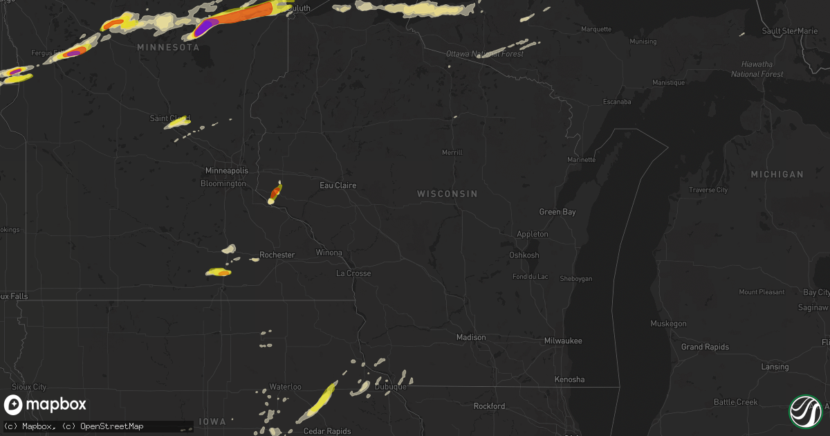
Hail Map in Wisconsin on August 31, 2018
Get this storm
August 31 map
$229
one time, instant access
Download today. No call, no setup
Keep the $229
Bought the map and want the full workflow? Apply the entire $229 to a subscription within 7 days. None of it is wasted.
Every map, not just this one
This buys you this map. Subscription and you get every map we run, in the markets you choose from a few cities to whole states to nationwide. Plus real-time alerts the moment a storm fires.
Contact data
Name, contact info, occupancy, even credit band for addresses in the footprint. You go from where it hit to who to call.
Become the source they trust
Unlimited branding weather history reports on demand. You already have the documented answer ready for the property owner, and you are the one who showed up with it.
Property data and RoofTrace estimates
Pull up any address you have got, its value and the exact code rules for that jurisdiction, straight from One Click Code. Then RoofTrace estimates the squares, pitch, and roof value, priced the way you price.
Storm reports in Wisconsin
Wisconsin
| Date | Description |
|---|---|
| 08/31/201811:42 AM CDT | A local report indicates 2.00 inch wind near ELLSWORTH |
| 08/31/201811:40 AM CDT | Ping pong to golf ball size hail... Lasted about 8 minutes. |
| 08/31/20186:38 AM CDT | At 1138 AM CDT, a severe thunderstorm was located over Ellsworth, or 11 miles southeast of River Falls, moving northeast at 20 mph. HAZARD...Quarter size hail. SOURCE...Radar indicated. IMPACT...Damage to vehicles is expected. This severe thunderstorm will remain over mainly rural areas of northeastern Pierce County, including the following locations... Beldenville, El Paso and Martel. |
| 08/31/20186:22 AM CDT | At 1122 PM CDT, a severe thunderstorm was located 9 miles south of Cornucopia, moving east at 50 mph. HAZARD...60 mph wind gusts and penny size hail. SOURCE...Radar indicated. IMPACT...Expect damage to roofs, siding, and trees. This severe thunderstorm will be near, Barksdale around 1130 PM CDT. Washburn around 1135 PM CDT. Ashland, Bayfield, La Pointe and Red Cliff around 1140 PM CDT. Odanah and Madeline Island around 1145 PM CDT. Other locations impacted by this severe thunderstorm include Big BayState Park, New Odanah, Stockton Island, Apostle Islands NationalLake Shore, Red Cliff Reservation, and Bad River Reservation. |
| 08/31/20185:02 AM CDT | At 1002 PM CDT, severe thunderstorms were located along a line extending from Saginaw, to near Scanlon, to near Carlton, moving east at 55 mph. HAZARD...Golf ball size hail and 70 mph wind gusts. SOURCE...Radar indicated. IMPACT...People and animals outdoors will be injured. Expect hail damage to roofs, siding, windows, and vehicles. Expect considerable tree damage. Wind damage is also likely to mobile homes, roofs, and outbuildings. Locations impacted include... Duluth, Superior, Cloquet, Hermantown, Proctor, Scanlon, Carlton, Oliver, Wrenshall, Thomson, Saginaw, Wisconsin Point, Pike Lake Near Duluth, City of Rice Lake, French River, Island Lake, Fond Du Lac Reservation, Grand Lake, Fredenberg, and Irving. |
| 08/31/20183:02 AM CDT | At 802 PM CDT, dangerous severe thunderstorms were located along a line extending from near Toivola, to near Brookston, to 7 miles southwest of Cloquet, moving east-northeast at 60 mph. These are very dangerous storms with a history of producing widespread wind damage across Aitkin County between 7 and 8 pm. HAZARD...90 mph wind gusts and penny size hail. SOURCE...Radar indicated. IMPACT...You are in a life-threatening situation. Flying debris may be deadly to those caught without shelter. Mobile homes will be heavily damaged or destroyed. Homes and businesses will have substantial roof and window damage. Expect extensive tree damage and power outages. Locations impacted include... Duluth, Superior, Cloquet, Hermantown, Two Harbors, Proctor, Scanlon, Carlton, Cotton, Thomson, Brookston, Meadowlands, Fairbanks, Wolf Lake, Boulder Lake, Brimson, Pike Lake Near Duluth, City of Rice Lake, Thomas Lake Near Brimson, and Whiteface Reservoir.People in the Cotton, Canyon, and Independence areas along Highway 53, as well as around Island Lake and Twig should seek shelter immediately!! |
| 08/31/20181:49 AM CDT | At 649 AM CDT, a severe thunderstorm was located over Luck, or 31 miles southeast of Pine City, moving northeast at 25 mph. HAZARD...Half dollar size hail. SOURCE...Radar indicated. IMPACT...Damage to vehicles is expected. This severe thunderstorm will be near... Frederic around 700 AM CDT.Other locations impacted by this severe thunderstorm include ClamFalls, Mckinley and Straight Lake Wilderness State Park. |
| 08/30/201811:06 PM CDT | At 406 AM CDT, a severe thunderstorm was located near Fifield, or 8 miles southeast of Park Falls, moving east at 40 mph. HAZARD...60 mph wind gusts and quarter size hail. SOURCE...Radar indicated. IMPACT...Hail damage to vehicles is expected. Expect wind damage to roofs, siding, and trees. Locations impacted include... Pike Lake. |
All States Impacted by Hail Map on August 31, 2018
Cities Impacted by Hail Map on August 31, 2018
- Kearney, NE
- Anita, IA
- Adair, IA
- Exira, IA
- Glenwood, IA
- Pacific Junction, IA
- Sutherland, NE
- Hershey, NE
- Holden, MO
- Harrisonville, MO
- Creighton, MO
- Garden City, MO
- Pelkie, MI
- Lanse, MI
- Wallace, NE
- Elsie, NE
- Madrid, NE
- Owatonna, MN
- Cloquet, MN
- Fairmount, ND
- Emerson, IA
- Imogene, IA
- Randolph, IA
- Malvern, IA
- Hastings, IA
- Ferrum, VA
- Council Bluffs, IA
- Grant, NE
- Venango, NE
- Clifton, AZ
- Halsey, NE
- Mount Ayr, IA
- Brock, NE
- Talmage, NE
- Martinsville, MO
- Braymer, MO
- Ludlow, MO
- Dawn, MO
- New Sharon, IA
- What Cheer, IA
- Rose Hill, IA
- Oskaloosa, IA
- Mayodan, NC
- Holton, KS
- Kellerton, IA
- Lamoni, IA
- Underwood, MN
- Arnold, NE
- Fairfax, MO
- Centerview, MO
- Odessa, MO
- Montezuma, IA
- Searsboro, IA
- Hartwick, IA
- Brooklyn, IA
- Malcom, IA
- Grinnell, IA
- Wadena, MN
- Deer Creek, MN
- Virginia Beach, VA
- Chesapeake, VA
- Concordia, MO
- Park, KS
- Axtell, NE
- Edison, NE
- Oxford, NE
- Minden, NE
- Atlanta, NE
- Bertrand, NE
- Funk, NE
- Holdrege, NE
- Heartwell, NE
- Kenesaw, NE
- Wood River, NE
- Henning, MN
- Clitherall, MN
- Vining, MN
- Fergus Falls, MN
- Battle Lake, MN
- Lucama, NC
- Wilson, NC
- Ellsworth, WI
- Fort Mill, SC
- Rock Hill, SC
- Papillion, NE
- Rush Center, KS
- Fisher, MN
- La Pointe, WI
- Gladbrook, IA
- Canyon, MN
- Alborn, MN
- Saginaw, MN
- Brookston, MN
- Peru, IA
- Campbellsburg, IN
- Crosslake, MN
- Pequot Lakes, MN
- Pine River, MN
- Nisswa, MN
- Otoe, NE
- Nebraska City, NE
- Lawson, MO
- Lathrop, MO
- Holt, MO
- Badger, MN
- Roseau, MN
- Bayfield, WI
- Cornucopia, WI
- San Carlos, AZ
- Brewster, NE
- Purdum, NE
- Higginsville, MO
- Corder, MO
- Gothenburg, NE
- Dickens, NE
- Cumberland, IA
- Griswold, IA
- Masonville, IA
- Coggon, IA
- Urbana, IA
- Rowley, IA
- Vinton, IA
- Winthrop, IA
- Center Point, IA
- Walker, IA
- Bloomfield, KY
- Knoxville, IA
- Corning, IA
- Villisca, IA
- Oshkosh, NE
- Chappell, NE
- Big Springs, NE
- Lewellen, NE
- White Pine, MI
- Wakefield, MI
- Bessemer, MI
- Ontonagon, MI
- Montour, IA
- Tama, IA
- Aurora, NC
- Scott City, KS
- Wiota, IA
- Edgewood, IA
- Toledo, IA
- Marne, IA
- Atlantic, IA
- Underwood, IA
- Crescent, IA
- Hager City, WI
- Marienthal, KS
- Cowgill, MO
- Floodwood, MN
- Wright, MN
- Sigourney, IA
- Stapleton, NE
- Arapahoe, NE
- Macedonia, IA
- Carbon, IA
- Lenox, IA
- Cromwell, IA
- Treynor, IA
- Oakland, IA
- Walnut, IA
- Grant, IA
- Massena, IA
- Bellevue, NE
- Red Oak, IA
- Stanton, IA
- Elliott, IA
- Silver City, IA
- Lewis, IA
- Henderson, IA
- Carson, IA
- Omaha, NE
- Diagonal, IA
- Prescott, IA
- Nodaway, IA
- Creston, IA
- Esko, MN
- Hancock, MI
- Aitkin, MN
- Tintah, MN
- Inverness, FL
- Chassell, MI
- Lake Linden, MI
- Harvey, IA
- Pella, IA
- Collyer, KS
- Quinter, KS
- Cromwell, MN
- Agra, KS
- Tryon, NE
- Stockville, NE
- Stuart, VA
- Woolwine, VA
- Hankinson, ND
- Crosby, MN
- Merrifield, MN
- Gonvick, MN
- Madison, NC
- Greenwood, DE
- Houston, DE
- Lincoln, DE
- Milford, DE
- Grinnell, KS
- Oakley, KS
- Gove, KS
- Leoti, KS
- Watersmeet, MI
- Eldridge, IA
- Bettendorf, IA
- Princeton, IA
- Davenport, IA
- Le Claire, IA
- Anselmo, NE
- Merna, NE
- Traer, IA
- Brayton, IA
- Lakin, KS
- Ulysses, KS
- Tracy, IA
- Meade, KS
- Afton, IA
- Warrensburg, MO
- West Point, NE
- Dodge, NE
- Weldon, IA
- Osceola, IA
- Eckerman, MI
- Essex, IA
- Meadowlands, MN
- Ramah, NM
- Carrollton, MO
- Norborne, MO
- Max Meadows, VA
- Campbell, MN
- Wahpeton, ND
- Hancock, IA
- Walsh, CO
- Bogard, MO
- Grants, NM
- Duluth, MN
- Palmyra, NE
- Unadilla, NE
- Pleasant Hill, MO
- Adams, NE
- Reinbeck, IA
- Gallatin, MO
- International Falls, MN
- Waterloo, IA
- Hudson, IA
- La Porte City, IA
- Alma, MO
- Blackburn, MO
- Britton, SD
- University Park, IA
- Gibson, IA
- Beacon, IA
- Fremont, IA
- Barnes City, IA
- Deep River, IA
- Delta, IA
- Keswick, IA
- Saint Francis, KS
- Goodland, KS
- Bird City, KS
- Kanorado, KS
- Johnson, KS
- East Grand Forks, MN
- Thompson, ND
- Paxton, NE
- Genoa, NE
- McClelland, IA
- Victor, IA
- Sebeka, MN
- Decatur, IA
- Freeman, MO
- New Effington, SD
- Sully, IA
- Isanti, MN
- Lemoyne, NE
- Brule, NE
- Ogallala, NE
- Keystone, NE
- Doniphan, NE
- Hastings, NE
- Juniata, NE
- Loomis, NE
- Giltner, NE
- Big Clifty, KY
- Leitchfield, KY
- Garfield, KY
- Eastview, KY
- Globe, AZ
- Chariton, IA
- Elizabethtown, NC
- Garland, NC
- Monroe, IA
- Reasnor, IA
- Verndale, MN
- Lutsen, MN
- Boone, IA
- Ogden, IA
- Moyock, NC
- Lynnville, IA
- Columbia, IA
- Mcgregor, MN
- Deerwood, MN
- Tamarack, MN
- Palisade, MN
- Melcher Dallas, IA
- Killduff, IA
- Newton, IA
- Bussey, IA
- Chelsea, IA
- Guernsey, IA
- Otley, IA
- Lovilia, IA
- Swan, IA
- Leighton, IA
- Hamilton, IA
- Staples, MN
- Motley, MN
- Creswell, NC
- Roper, NC
- Salem, NE
- Crystal Falls, MI
- Amasa, MI
- Hazel Green, WI
- Cuba City, WI
- Platteville, WI
- Salem, IN
- Springfield, CO
- Columbia, NC
- Pima, AZ
- Fontanelle, IA
- North Platte, NE
- Crookston, MN
- Mule Creek, NM
- Union, NE
- Murray, NE
- Emily, MN
- Clemons, IA
- Hayfield, MN
- Kasson, MN
- Dodge Center, MN
- Felton, DE
- Harrington, DE
- Kettle River, MN
- Sawyer, MN
- Winterset, IA
- Dalton, MN
- Goodridge, MN
- Columbus, NE
- Grant City, MO
- Parnell, MO
- Ravenwood, MO
- Plattsmouth, NE
- Curtis, NE
- Garden Grove, IA
- Knob Noster, MO
- Whiteman Air Force Base, MO
- Cameron, MO
- Turney, MO
- Rocky Mount, VA
- Clarkton, NC
- Shullsburg, WI
- Benton, WI
- Burdett, KS
- Pollocksville, NC
- Neola, IA
- East Dubuque, IL
- Muscotah, KS
- Effingham, KS
- Ironton, MN
- Port Wing, WI
- Big Lake, MN
- Becker, MN
- Farley, IA
- Dyersville, IA
- Iron River, MI
- Netawaka, KS
- Whiting, KS
- De Witt, IA
- Grand Mound, IA
- Kidder, MO
- Saint Cloud, MN
- Crystal River, FL
- Homosassa, FL
- Herbster, WI
- Geneva, MN
- Hartland, MN
- Ellendale, MN
- Clarks Grove, MN
- Hollandale, MN
- Kellogg, IA
- Gilman, IA
- Borden, IN
- Pickrell, NE
- Greene, IA
- Charles City, IA
- Manchester, IA
- Dundee, IA
- Clear Lake, MN
- Saint Joseph, MO
- Savannah, MO
- Graham, MO
- Skidmore, MO
- Craig, MO
- Maitland, MO
- Mound City, MO
- Forest City, MO
- Shelton, NE
- Gibbon, NE
- New Richland, MN
- Sparks, GA
- Adel, GA
- Oconto, NE
- Rogers, NE
- Schuyler, NE
- Howells, NE
- Mayview, MO
- Sweet Springs, MO
- Lexington, MO
- Davis City, IA
- Macksburg, IA
- Orient, IA
- Thayer, IA
- Murray, IA
- Mendon, MO
- Two Buttes, CO
- Grainfield, KS
- Calamus, IA
- Horton, KS
- Hiawatha, KS
- New Vienna, IA
- Worthington, IA
- Waverly, MO
- New York Mills, MN
- Ottertail, MN
- Worth, MO
- Sheridan, MO
- Lorimor, IA
- Lineville, IA
- Leon, IA
- Sublette, KS
- Phillipsburg, KS
- Kensington, KS
- Bloomington, NE
- Naponee, NE
- Mohawk, MI
- Redding, IA
- Blockton, IA
- Blooming Prairie, MN
- Claremont, MN
- Wytheville, VA
- Cripple Creek, VA
- Benson, NC
- Thief River Falls, MN
- Elkhart, KS
- Clearwater, MN
- La Monte, MO
- Washburn, WI
- Shelby, IA
- Falls City, NE
- Monticello, MN
- Macclesfield, NC
- Wellington, MO
- Elwood, NE
- Eustis, NE
- Dry Ridge, KY
- Foley, MN
- Bedford, IA
- Dunning, NE
- Nekoma, KS
- Maple Lake, MN
- Annandale, MN
- Wells, MN
- Roosevelt, MN
- Cotton, MN
- Zimmerman, MN
- Princeton, MN
- Miami, MO
- Oregon, MO
- Holland, IA
- Grundy Center, IA
- Mystic, IA
- Hamilton, MO
- Stantonsburg, NC
- Leeton, MO
- Garwin, IA
- Red Lake Falls, MN
- Cascade, IA
- Rulo, NE
- Barnard, MO
- Bolckow, MO
- White Cloud, KS
- Healy, KS
- Bardstown, KY
- Sunbury, NC
- Hobbsville, NC
- Guttenberg, IA
- Van Horne, IA
- Shellsburg, IA
- Garrison, IA
- Syracuse, NE
- Lynch Station, VA
- Belle Plaine, IA
- Keystone, IA
- Kingsville, MO
- Jacobson, MN
- Galena, IL
- New Castle, VA
- Garber, IA
- Brunswick, MO
- Frederica, DE
- Ellendale, DE
- Dubuque, IA
- Dike, IA
- Rosholt, SD
- Nashua, MN
- Lidgerwood, ND
- Madrid, IA
- Logan, KS
- Albemarle, NC
- Stockton, KS
- De Witt, MO
- Marshalltown, IA
- Bluffton, MN
- Menahga, MN
- Two Harbors, MN
- Emerado, ND
- Robinson, KS
- Highland, KS
- Eyota, MN
- Clarinda, IA
- Gravity, IA
- Edward, NC
- Lancaster, WI
- Cassville, WI
- Bloomington, WI
- Pekin, IN
- Moorefield, NE
- Saint Hilaire, MN
- Plummer, MN
- Morland, KS
- Holy Cross, IA
- Fillmore, MO
- Vallonia, IN
- Whiteriver, AZ
- Spring Valley, WI
- Auburn, NE
- La Vista, NE
- Mineola, IA
- Denver, MO
- Camanche, IA
- Malta Bend, MO
- Tingley, IA
- Shannon City, IA
- Bridgewater, IA
- New Market, IA
- Nehawka, NE
- Louisville, NE
- Offutt Afb, NE
- Ellston, IA
- Warwick, GA
- Beemer, NE
- Cambridge, MN
- Durango, IA
- Sherrill, IA
- Camden, NC
- Cecilia, KY
- Elk Creek, VA
- Dover, MO
- Long Grove, IA
- Belvidere, NC
- Grand River, IA
- Clearfield, IA
- Van Wert, IA
- Benton, IA
- Strasburg, MO
- Hill City, KS
- Penokee, KS
- Farragut, IA
- Greenfield, IA
- River Falls, WI
- Oberlin, KS
- Union Hall, VA
- Kimball, MN
- Kearney, MO
- Maiden, NC
- Newton, NC
- Hopkinton, IA
- Delhi, IA
- Epworth, IA
- Earlville, IA
- Elm Creek, NE
- Blairstown, MO
- Bates City, MO
- Lone Jack, MO
- Nashua, IA
- Avoca, IA
- Backus, MN
- Tomahawk, WI
- Rhinelander, WI
- Boulder Junction, WI
- Conception Junction, MO
- Beldenville, WI
- Sauk Rapids, MN
- Salol, MN
- Winona, KS


