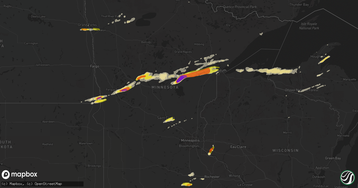
Hail Map in Minnesota on August 31, 2018
Get this storm
August 31 map
$229
one time, instant access
Download today. No call, no setup
Keep the $229
Bought the map and want the full workflow? Apply the entire $229 to a subscription within 7 days. None of it is wasted.
Every map, not just this one
This buys you this map. Subscription and you get every map we run, in the markets you choose from a few cities to whole states to nationwide. Plus real-time alerts the moment a storm fires.
Contact data
Name, contact info, occupancy, even credit band for addresses in the footprint. You go from where it hit to who to call.
Become the source they trust
Unlimited branding weather history reports on demand. You already have the documented answer ready for the property owner, and you are the one who showed up with it.
Property data and RoofTrace estimates
Pull up any address you have got, its value and the exact code rules for that jurisdiction, straight from One Click Code. Then RoofTrace estimates the squares, pitch, and roof value, priced the way you price.
Storm reports in Minnesota
Minnesota
| Date | Description |
|---|---|
| 08/31/20186:55 PM CDT | Many trees snapped 20-30 feet up. |
| 08/31/20186:53 PM CDT | Lots of trees and power lines knocked down. Time estimated from radar. |
| 08/31/20186:45 PM CDT | Lots of trees and power lines downed. Time estimated from radar. |
| 08/31/20186:36 PM CDT | Lots of tree damage and power lines downed. Time estimated from radar. |
| 08/31/20186:00 PM CDT | A local report indicates 1.50 inch wind near NIMROD |
| 08/31/20185:48 PM CDT | A local report indicates 1.00 inch wind near 1 W HENNING |
| 08/31/20185:45 PM CDT | Report and photo posted via social media. |
| 08/31/20185:40 PM CDT | Report and photo posted via social media. |
| 08/31/20185:32 PM CDT | A local report indicates 1.25 inch wind near 2 SSE CLITHERALL |
| 08/31/20185:30 PM CDT | Ten minute duration with hail stones up to half dollar with the average size around dimes |
| 08/31/20185:27 PM CDT | A local report indicates 2.00 inch wind near 1 S BATTLE LAKE |
| 08/31/20185:19 PM CDT | Report and photo posted via social media. Hail at fiske lake public access. |
| 08/31/20185:05 PM CDT | Radar estimated time. |
| 08/31/20182:55 PM CDT | Some dime to quarter sized hail fell in very heavy rain across northwest rapid river township. A few large branches were broken down as well. Time estimated based on ra |
| 08/31/20182:05 PM CDT | Lots of dime to quarter sized hail. |
| 08/31/20188:10 AM CDT | Many 2 to 3 inch hailstones. |
| 08/31/20187:45 AM CDT | Photo shared via twitter shows a couple of large tree branches down. |
| 08/31/20187:45 AM CDT | Reported near the intersection of county rd 20 and 35 in town of bath. |
| 08/31/20187:35 AM CDT | Corrects previous hail report from 4 nnw clarks grove. Reported near the intersection of county rd 20 and 35 in town of bath. Corrected time from 7:45 to 7:35 am. |
| 08/31/20187:25 AM CDT | A local report indicates 1.00 inch wind near 3 S NEW RICHLAND |
| 08/31/20185:31 AM CDT | At 1031 PM CDT, severe thunderstorms were located along a line extending from Wisconsin Point, to near South Range, to near Foxboro, moving southeast at 55 mph. HAZARD...70 mph wind gusts and nickel size hail. SOURCE...Radar indicated. IMPACT...Expect considerable tree damage. Damage is likely to mobile homes, roofs, and outbuildings. Locations impacted include... Superior, Hawthorne, Lake Nebagamon, Maple, Brule, Poplar In Douglas County, Solon Springs, Wisconsin Point, South Range, Bennett, Cloverland, Wentworth, Amnicon Lake, Amnicon Falls State Park, Pattison State Park, Blueberry, Waino, Patzau, and Lyman Lake. |
| 08/31/20185:08 AM CDT | At 1008 PM CDT, severe thunderstorms were located along a line extending from Boundary Waters Canoe Area Wilderness, to 7 miles northeast of Grand Marais, moving east at 50 mph. HAZARD...60 mph wind gusts and penny size hail. SOURCE...Radar indicated. IMPACT...Expect damage to roofs, siding, and trees. Locations impacted include... Grand Portage, Hovland, Pine Lake, Tom Lake, Bearskin Lake, Grand Portage Reservation, Judge C. R. Magney State Park, Poplar Lake, Daniels Lake, Judge Magney State Park, Watab Lake, Clearwater Lake, Swamp Lake, Grand Portage State Park, Two Island Lake, North Fowl Lake, and Brule Lake. |
| 08/31/20184:55 AM CDT | At 955 PM CDT, a severe thunderstorm was located near Fisher, or 18 miles southeast of Grand Forks, moving east at 35 mph. HAZARD...Quarter size hail. SOURCE...Radar indicated. IMPACT...Damage to vehicles is expected. This severe thunderstorm will be near... Crookston around 1005 PM CDT. Gentilly and Harold around 1015 PM CDT. Huot around 1020 PM CDT. Perault, Marcoux and Red Lake Falls around 1030 PM CDT. Dugdale around 1035 PM CDT. |
| 08/31/20184:41 AM CDT | At 940 PM CDT, a severe thunderstorm was located 7 miles northeast of Cromwell, or 14 miles west of Cloquet, moving east at 50 mph. HAZARD...70 mph wind gusts and quarter size hail. SOURCE...Radar indicated. IMPACT...Hail damage to vehicles is expected. Expect considerable tree damage. Wind damage is also likely to mobile homes, roofs, and outbuildings. Locations impacted include... Cloquet, Brookston, Fond Du Lac Reservation, and Mahnomen. |
| 08/31/20184:24 AM CDT | At 924 PM CDT, severe thunderstorms were located along a line extending from 6 miles southeast of Forest Center, to near Taconite Harbor, moving northeast at 50 mph. HAZARD...60 mph wind gusts. SOURCE...Radar indicated. IMPACT...Expect damage to roofs, siding, and trees. Locations impacted include... Grand Marais, Clear Lake, Lutsen, Tofte, Eagle Mountain, Taconite Harbor, Dumbbell Lake, Perent Lake, Temperance River State Park, Phoebe Lake, Kawishiwi Lake, White Pine Lake, Silver Island Lake, Brule Lake, Cherokee Lake, Cascade River State Park, George Manitou State Park, Devil Track Lake, Tail Lake, and Crescent Lake. |
| 08/31/20184:18 AM CDT | At 918 PM CDT, severe thunderstorms were located along a line extending from 7 miles east of Big Sandy Lake, to near Tamarack, moving east at 30 mph. HAZARD...Golf ball size hail and 60 mph wind gusts. SOURCE...Radar indicated. IMPACT...People and animals outdoors will be injured. Expect hail damage to roofs, siding, windows, and vehicles. Expect wind damage to roofs, siding, and trees. Locations impacted include... Cromwell, Tamarack, and Wright. |
| 08/31/20184:16 AM CDT | At 915 PM CDT, a severe thunderstorm was located near Thompson, or 9 miles southwest of Grand Forks, moving east at 15 mph. HAZARD...Quarter size hail. SOURCE...Radar indicated. IMPACT...Damage to vehicles is expected. This severe thunderstorm will be near... Thompson and Merrifield around 930 PM CDT. Grand Forks around 935 PM CDT. Bygland, Mallory and Davidson around 1000 PM CDT.This includes Interstate 29 between mile markers 125 and 136. |
| 08/31/20183:56 AM CDT | At 856 PM CDT, a severe thunderstorm was located near Palisade, or 13 miles southwest of Big Sandy Lake, moving east at 30 mph. HAZARD...Golf ball size hail and 60 mph wind gusts. SOURCE...Radar indicated. IMPACT...People and animals outdoors will be injured. Expect hail damage to roofs, siding, windows, and vehicles. Expect wind damage to roofs, siding, and trees. Locations impacted include... Mcgregor, Flowage Lake, and Gun Lake. |
| 08/31/20183:47 AM CDT | At 847 PM CDT, a severe thunderstorm was located near Tamarack, or near Big Sandy Lake, moving northeast at 45 mph. HAZARD...Golf ball size hail and 60 mph wind gusts. SOURCE...Radar indicated. IMPACT...People and animals outdoors will be injured. Expect hail damage to roofs, siding, windows, and vehicles. Expect wind damage to roofs, siding, and trees. Locations impacted include... Big Sandy Lake, Tamarack, Wright, Balsam, Sheshebee, and Savanna Portage State Park. |
| 08/31/20183:42 AM CDT | At 842 PM CDT, severe thunderstorms were located along a line extending from 8 miles north of Fairbanks, to near Brimson, to near French River, moving east at 65 mph. HAZARD...70 mph wind gusts. SOURCE...Radar indicated. IMPACT...Expect considerable tree damage. Damage is likely to mobile homes, roofs, and outbuildings. Locations impacted include... Duluth, Two Harbors, Hoyt Lakes, Silver Bay, Babbitt, Clear Lake, Lutsen, Tofte, Beaver Bay, Fairbanks, Wolf Lake, Little Marais, Larsmont, Brimson, Whyte, Castle Danger, Knife River, Taconite Harbor, Thomas Lake Near Brimson, and Finland. |
| 08/31/20183:11 AM CDT | At 811 PM CDT, a severe thunderstorm was located over Aitkin, or 12 miles north of Mille Lacs Lake, moving east at 45 mph. HAZARD...60 mph wind gusts and quarter size hail. SOURCE...Radar indicated. IMPACT...Hail damage to vehicles is expected. Expect wind damage to roofs, siding, and trees. Locations impacted include... Aitkin, Mcgregor, Cedar Lake, Kimberly, Hassman, Rossburg, Pine Knoll, Ripple Lake, and Rice Lake Wildlife Refuge. |
| 08/31/20182:28 AM CDT | At 725 PM CDT, dangerous severe thunderstorms were located along a line extending from 7 miles south of Jacobson, to near Mcgregor, moving east at 65 mph. These are extremely dangerous storms! HAZARD...100 mph wind gusts and penny size hail. SOURCE...Radar indicated. Wind damage has been reported by law enforcement across Aitkin County. IMPACT...You are in a life-threatening situation. Flying debris may be deadly to those caught without shelter. Mobile homes will be destroyed. Expect considerable damage to homes and businesses. Expect extensive tree damage and power outages. Locations impacted include... Cloquet, Big Sandy Lake, Scanlon, Carlton, Mahtowa, Floodwood, Wrenshall, Mcgregor, Cromwell, Palisade, Thomson, Brookston, Tamarack, Libby, Saginaw, Fond Du Lac Reservation, Canyon, Grand Lake, Mahnomen, and Alborn.People in and around Big Sandy Lake and Savanna Portage State Park should prepare immediately for wind speeds from 80 to 100 mph that will cause widespread tree damage. Seek shelter now!!! |
| 08/31/20182:24 AM CDT | At 724 AM CDT, a severe thunderstorm was located near Hartland, or 13 miles north of Albert Lea, moving east at 25 mph. HAZARD...Ping pong ball size hail. SOURCE...Radar indicated. IMPACT...People and animals outdoors will be injured. Expect damage to roofs, siding, windows, and vehicles. Locations impacted include... Blooming Prairie, Clarks Grove, Ellendale, Geneva, Hartland, Hollandale and Bixby.This includes Interstate 35 between mile markers 18 and 29. |
| 08/31/20181:44 AM CDT | At 644 PM CDT, a large severe thunderstorm was located over Crosslake, or 21 miles north of Brainerd, moving east at 45 mph. HAZARD...70 mph wind gusts and half dollar size hail. SOURCE...Radar indicated. IMPACT...Hail damage to vehicles is expected. Expect considerable tree damage. Wind damage is also likely to mobile homes, roofs, and outbuildings. Locations impacted include... Big Sandy Lake, Crosby, Breezy Point, Aitkin, Crosslake, Emily, Ironton, Deerwood, Mcgregor, Fifty Lakes, Cuyuna, Palisade, Libby, Outing, Merrifield, Swatara, Cedar Lake, Mission, Wolford, and Waukenabo. |
| 08/31/20181:10 AM CDT | At 609 AM CDT, severe thunderstorms were located along a line extending from near Janesville to near Pemberton, moving east at 30 mph. HAZARD...Half dollar size hail. SOURCE...Radar indicated. IMPACT...Damage to vehicles is expected. Severe thunderstorms will be near... Waseca around 645 AM CDT. Medford around 650 AM CDT. |
| 08/31/20181:09 AM CDT | At 609 PM CDT, severe thunderstorms were located along a line extending from 7 miles west of Backus, to near Leader, moving east at 40 mph. HAZARD...60 mph wind gusts and half dollar size hail. SOURCE...Radar indicated. IMPACT...Hail damage to vehicles is expected. Expect wind damage to roofs, siding, and trees. Locations impacted include... Brainerd, Baxter, Breezy Point, Pequot Lakes, Crosslake, Nisswa, Pine River, Pillager, Fifty Lakes, Wabedo, Backus, Poplar, Leader, Gull Lake, Merrifield, Woman Lake, Sylvan, Lake Shore, East Gull Lake, and Oshawa. |
| 08/31/201812:57 AM CDT | At 556 PM CDT, severe thunderstorms were located along a line extending from Oshawa to near Deer Creek, moving northeast at 45 mph. HAZARD...60 mph wind gusts and half dollar size hail. SOURCE...Radar indicated. IMPACT...Hail damage to vehicles is expected. Expect wind damage to roofs, siding, and trees. Severe thunderstorms will be near... Verndale around 615 PM CDT. Blue Grass and Aldrich around 620 PM CDT. Oylen around 630 PM CDT. |
| 08/31/201812:33 AM CDT | At 532 PM CDT, a severe thunderstorm was located near Sebeka, or 37 miles southeast of Detroit Lakes, moving northeast at 45 mph. HAZARD...60 mph wind gusts and quarter size hail. SOURCE...Radar indicated. IMPACT...Hail damage to vehicles is expected. Expect wind damage to roofs, siding, and trees. This severe thunderstorm will be near... Sebeka and Blue Grass around 540 PM CDT. Nimrod and Oylen around 555 PM CDT. |
| 08/31/201812:09 AM CDT | At 509 PM CDT, a severe thunderstorm was located near Dalton, or 8 miles southeast of Fergus Falls, moving northeast at 45 mph. HAZARD...60 mph wind gusts and quarter size hail. SOURCE...Radar indicated. IMPACT...Hail damage to vehicles is expected. Expect wind damage to roofs, siding, and trees. This severe thunderstorm will be near... Underwood around 515 PM CDT. Phelps around 520 PM CDT. Battle Lake, Glendalough State Park and Clitherall around 525 PM CDT. Vining around 530 PM CDT. Ottertail and Henning around 540 PM CDT.This includes Interstate 94 in Minnesota between mile markers 53 and70. |
| 08/30/201811:30 PM CDT | A few dime to quarter sized hail noted in eastern malung township. Report and photo posted via social media. |
| 08/30/201810:28 PM CDT | At 328 PM CDT, a severe thunderstorm was located near Manitou, or 27 miles west of International Falls, moving northeast at 40 mph. HAZARD...60 mph wind gusts and quarter size hail. SOURCE...Radar indicated. IMPACT...Hail damage to vehicles is expected. Expect wind damage to roofs, siding, and trees. Locations impacted include... Loman, Manitou, and Indus. |
| 08/30/201810:13 PM CDT | Most hail stones pea to penny size. |
| 08/30/201810:05 PM CDT | A local report indicates 1.00 inch wind near 2 WSW HERMANTOWN |
| 08/30/20189:58 PM CDT | At 258 PM CDT, a severe thunderstorm was located near Baudette, moving northeast at 50 mph. HAZARD...60 mph wind gusts and half dollar size hail. SOURCE...Radar indicated. IMPACT...Hail damage to vehicles is expected. Expect wind damage to roofs, siding, and trees. Locations impacted include... Birchdale. |
| 08/30/20189:57 PM CDT | A few nickel to quarter sized hail in brief heavy rain was noted across east central fisher and west central lowell townships. |
| 08/30/20189:31 PM CDT | At 230 PM CDT, a severe thunderstorm was located 9 miles southeast of Gates Corner, or 42 miles southeast of Roseau, moving northeast at 55 mph. HAZARD...60 mph wind gusts and half dollar size hail. SOURCE...Radar indicated. IMPACT...Hail damage to vehicles is expected. Expect wind damage to roofs, siding, and trees. This severe thunderstorm will be near... Oaks Corner around 240 PM CDT. Carp around 255 PM CDT. Clementson around 310 PM CDT. |
| 08/30/20189:20 PM CDT | A local report indicates 1.00 inch wind near TAMARACK |
| 08/30/20188:58 PM CDT | Several pine trees knocked down. Time estimated from radar. |
| 08/30/20188:53 PM CDT | At 153 PM CDT, a severe thunderstorm was located near High Landing, or 11 miles southeast of Thief River Falls, moving northeast at 45 mph. HAZARD...60 mph wind gusts and half dollar size hail. SOURCE...Radar indicated. IMPACT...Hail damage to vehicles is expected. Expect wind damage to roofs, siding, and trees. This severe thunderstorm will be near... High Landing and Mavie around 200 PM CDT. Goodridge around 205 PM CDT. Espelie around 215 PM CDT. Carmel around 230 PM CDT. Jelle around 235 PM CDT. |
| 08/30/20188:48 PM CDT | Few trees knocked down. Time estimated from radar. |
| 08/30/20188:30 PM CDT | Large trees down over 8th ave west. |
| 08/30/20188:30 PM CDT | Large tree crushed car. |
| 08/30/20188:25 PM CDT | 2 large trees blown down blocking road near bayview school. |
| 08/30/20188:15 PM CDT | Hail stones shattered the back window of a vehicle. Time estimated from radar. |
| 08/30/20188:13 PM CDT | A local report indicates 2.75 inch wind near 1 ESE AITKIN |
| 08/30/20188:13 PM CDT | A local report indicates 1.75 inch wind near AITKIN |
| 08/30/20188:12 PM CDT | Largest hailstone was 3.25 inches and was an ellipsoid in shape. |
| 08/30/20188:10 PM CDT | Corrects previous hail report from 1 ese aitkin. Many 2 to 3 inch hailstones. |
| 08/30/20188:03 PM CDT | Few trees knocked down along highway 210 from cromwell to cloquet. Time estimated from radar. |
| 08/30/20187:25 PM CDT | Pontoon and boat lift flipped upside down on big sandy lake. |
| 08/30/20187:24 PM CDT | A large swath of tree damage and power lines down between mile post 127 to 136 on hwy 65. |
| 08/30/20187:15 PM CDT | Large tree over hwy 169 just north of hwy 210 intersection. |
| 08/30/20187:14 PM CDT | *** 1 inj *** corrects previous tstm wnd dmg report from 2 s waukenabo. Law enforcement reported a home sustained significant damage. Downed trees blocked hwy 3. Time e |
All States Impacted by Hail Map on August 31, 2018
Cities Impacted by Hail Map on August 31, 2018
- Kearney, NE
- Anita, IA
- Adair, IA
- Exira, IA
- Glenwood, IA
- Pacific Junction, IA
- Sutherland, NE
- Hershey, NE
- Holden, MO
- Harrisonville, MO
- Creighton, MO
- Garden City, MO
- Pelkie, MI
- Lanse, MI
- Wallace, NE
- Elsie, NE
- Madrid, NE
- Owatonna, MN
- Cloquet, MN
- Fairmount, ND
- Emerson, IA
- Imogene, IA
- Randolph, IA
- Malvern, IA
- Hastings, IA
- Ferrum, VA
- Council Bluffs, IA
- Grant, NE
- Venango, NE
- Clifton, AZ
- Halsey, NE
- Mount Ayr, IA
- Brock, NE
- Talmage, NE
- Martinsville, MO
- Braymer, MO
- Ludlow, MO
- Dawn, MO
- New Sharon, IA
- What Cheer, IA
- Rose Hill, IA
- Oskaloosa, IA
- Mayodan, NC
- Holton, KS
- Kellerton, IA
- Lamoni, IA
- Underwood, MN
- Arnold, NE
- Fairfax, MO
- Centerview, MO
- Odessa, MO
- Montezuma, IA
- Searsboro, IA
- Hartwick, IA
- Brooklyn, IA
- Malcom, IA
- Grinnell, IA
- Wadena, MN
- Deer Creek, MN
- Virginia Beach, VA
- Chesapeake, VA
- Concordia, MO
- Park, KS
- Axtell, NE
- Edison, NE
- Oxford, NE
- Minden, NE
- Atlanta, NE
- Bertrand, NE
- Funk, NE
- Holdrege, NE
- Heartwell, NE
- Kenesaw, NE
- Wood River, NE
- Henning, MN
- Clitherall, MN
- Vining, MN
- Fergus Falls, MN
- Battle Lake, MN
- Lucama, NC
- Wilson, NC
- Ellsworth, WI
- Fort Mill, SC
- Rock Hill, SC
- Papillion, NE
- Rush Center, KS
- Fisher, MN
- La Pointe, WI
- Gladbrook, IA
- Canyon, MN
- Alborn, MN
- Saginaw, MN
- Brookston, MN
- Peru, IA
- Campbellsburg, IN
- Crosslake, MN
- Pequot Lakes, MN
- Pine River, MN
- Nisswa, MN
- Otoe, NE
- Nebraska City, NE
- Lawson, MO
- Lathrop, MO
- Holt, MO
- Badger, MN
- Roseau, MN
- Bayfield, WI
- Cornucopia, WI
- San Carlos, AZ
- Brewster, NE
- Purdum, NE
- Higginsville, MO
- Corder, MO
- Gothenburg, NE
- Dickens, NE
- Cumberland, IA
- Griswold, IA
- Masonville, IA
- Coggon, IA
- Urbana, IA
- Rowley, IA
- Vinton, IA
- Winthrop, IA
- Center Point, IA
- Walker, IA
- Bloomfield, KY
- Knoxville, IA
- Corning, IA
- Villisca, IA
- Oshkosh, NE
- Chappell, NE
- Big Springs, NE
- Lewellen, NE
- White Pine, MI
- Wakefield, MI
- Bessemer, MI
- Ontonagon, MI
- Montour, IA
- Tama, IA
- Aurora, NC
- Scott City, KS
- Wiota, IA
- Edgewood, IA
- Toledo, IA
- Marne, IA
- Atlantic, IA
- Underwood, IA
- Crescent, IA
- Hager City, WI
- Marienthal, KS
- Cowgill, MO
- Floodwood, MN
- Wright, MN
- Sigourney, IA
- Stapleton, NE
- Arapahoe, NE
- Macedonia, IA
- Carbon, IA
- Lenox, IA
- Cromwell, IA
- Treynor, IA
- Oakland, IA
- Walnut, IA
- Grant, IA
- Massena, IA
- Bellevue, NE
- Red Oak, IA
- Stanton, IA
- Elliott, IA
- Silver City, IA
- Lewis, IA
- Henderson, IA
- Carson, IA
- Omaha, NE
- Diagonal, IA
- Prescott, IA
- Nodaway, IA
- Creston, IA
- Esko, MN
- Hancock, MI
- Aitkin, MN
- Tintah, MN
- Inverness, FL
- Chassell, MI
- Lake Linden, MI
- Harvey, IA
- Pella, IA
- Collyer, KS
- Quinter, KS
- Cromwell, MN
- Agra, KS
- Tryon, NE
- Stockville, NE
- Stuart, VA
- Woolwine, VA
- Hankinson, ND
- Crosby, MN
- Merrifield, MN
- Gonvick, MN
- Madison, NC
- Greenwood, DE
- Houston, DE
- Lincoln, DE
- Milford, DE
- Grinnell, KS
- Oakley, KS
- Gove, KS
- Leoti, KS
- Watersmeet, MI
- Eldridge, IA
- Bettendorf, IA
- Princeton, IA
- Davenport, IA
- Le Claire, IA
- Anselmo, NE
- Merna, NE
- Traer, IA
- Brayton, IA
- Lakin, KS
- Ulysses, KS
- Tracy, IA
- Meade, KS
- Afton, IA
- Warrensburg, MO
- West Point, NE
- Dodge, NE
- Weldon, IA
- Osceola, IA
- Eckerman, MI
- Essex, IA
- Meadowlands, MN
- Ramah, NM
- Carrollton, MO
- Norborne, MO
- Max Meadows, VA
- Campbell, MN
- Wahpeton, ND
- Hancock, IA
- Walsh, CO
- Bogard, MO
- Grants, NM
- Duluth, MN
- Palmyra, NE
- Unadilla, NE
- Pleasant Hill, MO
- Adams, NE
- Reinbeck, IA
- Gallatin, MO
- International Falls, MN
- Waterloo, IA
- Hudson, IA
- La Porte City, IA
- Alma, MO
- Blackburn, MO
- Britton, SD
- University Park, IA
- Gibson, IA
- Beacon, IA
- Fremont, IA
- Barnes City, IA
- Deep River, IA
- Delta, IA
- Keswick, IA
- Saint Francis, KS
- Goodland, KS
- Bird City, KS
- Kanorado, KS
- Johnson, KS
- East Grand Forks, MN
- Thompson, ND
- Paxton, NE
- Genoa, NE
- McClelland, IA
- Victor, IA
- Sebeka, MN
- Decatur, IA
- Freeman, MO
- New Effington, SD
- Sully, IA
- Isanti, MN
- Lemoyne, NE
- Brule, NE
- Ogallala, NE
- Keystone, NE
- Doniphan, NE
- Hastings, NE
- Juniata, NE
- Loomis, NE
- Giltner, NE
- Big Clifty, KY
- Leitchfield, KY
- Garfield, KY
- Eastview, KY
- Globe, AZ
- Chariton, IA
- Elizabethtown, NC
- Garland, NC
- Monroe, IA
- Reasnor, IA
- Verndale, MN
- Lutsen, MN
- Boone, IA
- Ogden, IA
- Moyock, NC
- Lynnville, IA
- Columbia, IA
- Mcgregor, MN
- Deerwood, MN
- Tamarack, MN
- Palisade, MN
- Melcher Dallas, IA
- Killduff, IA
- Newton, IA
- Bussey, IA
- Chelsea, IA
- Guernsey, IA
- Otley, IA
- Lovilia, IA
- Swan, IA
- Leighton, IA
- Hamilton, IA
- Staples, MN
- Motley, MN
- Creswell, NC
- Roper, NC
- Salem, NE
- Crystal Falls, MI
- Amasa, MI
- Hazel Green, WI
- Cuba City, WI
- Platteville, WI
- Salem, IN
- Springfield, CO
- Columbia, NC
- Pima, AZ
- Fontanelle, IA
- North Platte, NE
- Crookston, MN
- Mule Creek, NM
- Union, NE
- Murray, NE
- Emily, MN
- Clemons, IA
- Hayfield, MN
- Kasson, MN
- Dodge Center, MN
- Felton, DE
- Harrington, DE
- Kettle River, MN
- Sawyer, MN
- Winterset, IA
- Dalton, MN
- Goodridge, MN
- Columbus, NE
- Grant City, MO
- Parnell, MO
- Ravenwood, MO
- Plattsmouth, NE
- Curtis, NE
- Garden Grove, IA
- Knob Noster, MO
- Whiteman Air Force Base, MO
- Cameron, MO
- Turney, MO
- Rocky Mount, VA
- Clarkton, NC
- Shullsburg, WI
- Benton, WI
- Burdett, KS
- Pollocksville, NC
- Neola, IA
- East Dubuque, IL
- Muscotah, KS
- Effingham, KS
- Ironton, MN
- Port Wing, WI
- Big Lake, MN
- Becker, MN
- Farley, IA
- Dyersville, IA
- Iron River, MI
- Netawaka, KS
- Whiting, KS
- De Witt, IA
- Grand Mound, IA
- Kidder, MO
- Saint Cloud, MN
- Crystal River, FL
- Homosassa, FL
- Herbster, WI
- Geneva, MN
- Hartland, MN
- Ellendale, MN
- Clarks Grove, MN
- Hollandale, MN
- Kellogg, IA
- Gilman, IA
- Borden, IN
- Pickrell, NE
- Greene, IA
- Charles City, IA
- Manchester, IA
- Dundee, IA
- Clear Lake, MN
- Saint Joseph, MO
- Savannah, MO
- Graham, MO
- Skidmore, MO
- Craig, MO
- Maitland, MO
- Mound City, MO
- Forest City, MO
- Shelton, NE
- Gibbon, NE
- New Richland, MN
- Sparks, GA
- Adel, GA
- Oconto, NE
- Rogers, NE
- Schuyler, NE
- Howells, NE
- Mayview, MO
- Sweet Springs, MO
- Lexington, MO
- Davis City, IA
- Macksburg, IA
- Orient, IA
- Thayer, IA
- Murray, IA
- Mendon, MO
- Two Buttes, CO
- Grainfield, KS
- Calamus, IA
- Horton, KS
- Hiawatha, KS
- New Vienna, IA
- Worthington, IA
- Waverly, MO
- New York Mills, MN
- Ottertail, MN
- Worth, MO
- Sheridan, MO
- Lorimor, IA
- Lineville, IA
- Leon, IA
- Sublette, KS
- Phillipsburg, KS
- Kensington, KS
- Bloomington, NE
- Naponee, NE
- Mohawk, MI
- Redding, IA
- Blockton, IA
- Blooming Prairie, MN
- Claremont, MN
- Wytheville, VA
- Cripple Creek, VA
- Benson, NC
- Thief River Falls, MN
- Elkhart, KS
- Clearwater, MN
- La Monte, MO
- Washburn, WI
- Shelby, IA
- Falls City, NE
- Monticello, MN
- Macclesfield, NC
- Wellington, MO
- Elwood, NE
- Eustis, NE
- Dry Ridge, KY
- Foley, MN
- Bedford, IA
- Dunning, NE
- Nekoma, KS
- Maple Lake, MN
- Annandale, MN
- Wells, MN
- Roosevelt, MN
- Cotton, MN
- Zimmerman, MN
- Princeton, MN
- Miami, MO
- Oregon, MO
- Holland, IA
- Grundy Center, IA
- Mystic, IA
- Hamilton, MO
- Stantonsburg, NC
- Leeton, MO
- Garwin, IA
- Red Lake Falls, MN
- Cascade, IA
- Rulo, NE
- Barnard, MO
- Bolckow, MO
- White Cloud, KS
- Healy, KS
- Bardstown, KY
- Sunbury, NC
- Hobbsville, NC
- Guttenberg, IA
- Van Horne, IA
- Shellsburg, IA
- Garrison, IA
- Syracuse, NE
- Lynch Station, VA
- Belle Plaine, IA
- Keystone, IA
- Kingsville, MO
- Jacobson, MN
- Galena, IL
- New Castle, VA
- Garber, IA
- Brunswick, MO
- Frederica, DE
- Ellendale, DE
- Dubuque, IA
- Dike, IA
- Rosholt, SD
- Nashua, MN
- Lidgerwood, ND
- Madrid, IA
- Logan, KS
- Albemarle, NC
- Stockton, KS
- De Witt, MO
- Marshalltown, IA
- Bluffton, MN
- Menahga, MN
- Two Harbors, MN
- Emerado, ND
- Robinson, KS
- Highland, KS
- Eyota, MN
- Clarinda, IA
- Gravity, IA
- Edward, NC
- Lancaster, WI
- Cassville, WI
- Bloomington, WI
- Pekin, IN
- Moorefield, NE
- Saint Hilaire, MN
- Plummer, MN
- Morland, KS
- Holy Cross, IA
- Fillmore, MO
- Vallonia, IN
- Whiteriver, AZ
- Spring Valley, WI
- Auburn, NE
- La Vista, NE
- Mineola, IA
- Denver, MO
- Camanche, IA
- Malta Bend, MO
- Tingley, IA
- Shannon City, IA
- Bridgewater, IA
- New Market, IA
- Nehawka, NE
- Louisville, NE
- Offutt Afb, NE
- Ellston, IA
- Warwick, GA
- Beemer, NE
- Cambridge, MN
- Durango, IA
- Sherrill, IA
- Camden, NC
- Cecilia, KY
- Elk Creek, VA
- Dover, MO
- Long Grove, IA
- Belvidere, NC
- Grand River, IA
- Clearfield, IA
- Van Wert, IA
- Benton, IA
- Strasburg, MO
- Hill City, KS
- Penokee, KS
- Farragut, IA
- Greenfield, IA
- River Falls, WI
- Oberlin, KS
- Union Hall, VA
- Kimball, MN
- Kearney, MO
- Maiden, NC
- Newton, NC
- Hopkinton, IA
- Delhi, IA
- Epworth, IA
- Earlville, IA
- Elm Creek, NE
- Blairstown, MO
- Bates City, MO
- Lone Jack, MO
- Nashua, IA
- Avoca, IA
- Backus, MN
- Tomahawk, WI
- Rhinelander, WI
- Boulder Junction, WI
- Conception Junction, MO
- Beldenville, WI
- Sauk Rapids, MN
- Salol, MN
- Winona, KS


