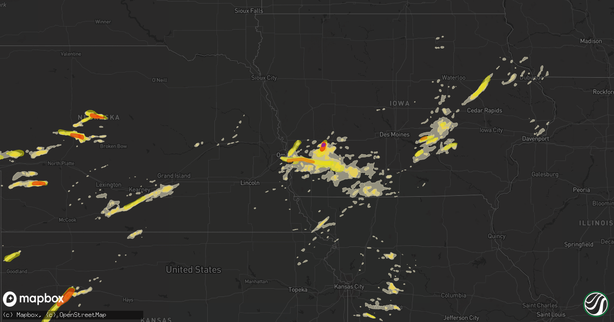
Hail Map on August 31, 2018
Get this storm
August 31 map
$229
one time, instant access
Download today. No call, no setup
Keep the $229
Bought the map and want the full workflow? Apply the entire $229 to a subscription within 7 days. None of it is wasted.
Every map, not just this one
This buys you this map. Subscription and you get every map we run, in the markets you choose from a few cities to whole states to nationwide. Plus real-time alerts the moment a storm fires.
Contact data
Name, contact info, occupancy, even credit band for addresses in the footprint. You go from where it hit to who to call.
Become the source they trust
Unlimited branding weather history reports on demand. You already have the documented answer ready for the property owner, and you are the one who showed up with it.
Property data and RoofTrace estimates
Pull up any address you have got, its value and the exact code rules for that jurisdiction, straight from One Click Code. Then RoofTrace estimates the squares, pitch, and roof value, priced the way you price.
States Impacted by Hail Map on August 31, 2018
Storm reports
Nebraska
| Date | Description |
|---|---|
| 08/31/20186:49 PM CDT | A local report indicates 1.75 inch wind near 7 ENE STAPLETON |
| 08/31/20185:58 PM CDT | A local report indicates 1.00 inch wind near 5 NW DUNNING |
| 08/31/20184:55 PM CDT | Report via social media |
| 08/31/20184:17 PM CDT | Report via social media with pictures. |
| 08/31/20189:00 AM CDT | Public report with pictures on facebook. Time estimated from radar. |
| 08/31/20187:26 AM CDT | At 1226 AM CDT, a severe thunderstorm was located near Powhattan, moving northeast at 20 mph. HAZARD...60 mph wind gusts and quarter size hail. SOURCE...Radar indicated. IMPACT...Hail damage to vehicles is expected. Expect wind damage to roofs, siding, and trees. Locations impacted include... Hiawatha, Fairview, Robinson, Reserve, Powhattan and Hamlin. |
| 08/31/20185:13 AM CDT | At 1013 PM CDT, a severe thunderstorm was located near Wallace, or 20 miles north of Hayes Center, moving east at 30 mph. HAZARD...Ping pong ball size hail and 60 mph wind gusts. SOURCE...Radar indicated. IMPACT...People and animals outdoors will be injured. Expect hail damage to roofs, siding, windows, and vehicles. Expect wind damage to roofs, siding, and trees. Locations impacted include... Wallace, Dickens and Somerset. |
| 08/31/20183:51 AM CDT | At 851 PM CDT, a severe thunderstorm was located 10 miles north of Sutherland, or 20 miles southwest of Tryon, moving northeast at 25 mph. HAZARD...60 mph wind gusts and quarter size hail. SOURCE...Radar indicated. IMPACT...Hail damage to vehicles is expected. Expect wind damage to roofs, siding, and trees. This severe thunderstorm will remain over mainly rural areas of northwestern Lincoln and south central McPherson Counties.This includes the following highways... Highway 92 between mile markers 198 and 204. Highway 97 between mile markers 9 and 19, and near mile marker 32. |
| 08/31/20182:26 AM CDT | Large tree limbs/branches down in the city. Pictures from facebook. Time estimated from radar. |
| 08/31/20182:23 AM CDT | Pictures from facebook show very large tree limbs down on top of vehicles and a home. No damage known to home or vehicle. Time estimated from radar. |
| 08/31/20182:03 AM CDT | A local report indicates 58 MPH wind near GRAND ISLAND AIRPORT |
| 08/31/20181:54 AM CDT | At 653 PM MDT, a severe thunderstorm was located over Lemoyne, or 10 miles north of Ogallala, moving east at 20 mph. HAZARD...60 mph wind gusts and quarter size hail. SOURCE...Radar indicated. IMPACT...Hail damage to vehicles is expected. Expect wind damage to roofs, siding, and trees. Locations impacted include... Lemoyne, Keystone, Kingsley Dam, Big Bald Hill, Bucktail Lake, Broganville and Lake View Campground.This includes the following highways... Highway 61 between mile markers 94 and 111. Highway 92 between mile markers 128 and 138. |
| 08/31/20181:50 AM CDT | Large diameter limb... Upwards to a foot... Down. Estimated 60-70 mph winds. Noted tree damage not widespread... But it is noticeable around town. |
| 08/31/20181:41 AM CDT | At 641 PM CDT, a severe thunderstorm was located 7 miles northeast of Gandy, or 10 miles northeast of Stapleton, moving east at 20 mph. HAZARD...60 mph wind gusts and quarter size hail. SOURCE...Radar indicated. IMPACT...Hail damage to vehicles is expected. Expect wind damage to roofs, siding, and trees. Locations impacted include... Arnold, Logan, Tarboz Lake, Shanklin Bluff, Pleasant Hill, Hoagland and Finchville.This includes Highway 92 between mile markers 243 and 260. |
| 08/31/20181:34 AM CDT | A local report indicates 60 MPH wind near HASTINGS AIRPORT |
| 08/31/20181:33 AM CDT | A local report indicates 69 MPH wind near 2 NNE NORMAN |
| 08/31/201812:59 AM CDT | At 559 PM MDT, a severe thunderstorm was located near Lewellen, or 10 miles southeast of Oshkosh, moving east at 15 mph. HAZARD...60 mph wind gusts and quarter size hail. SOURCE...Radar indicated. IMPACT...Hail damage to vehicles is expected. Expect wind damage to roofs, siding, and trees. Locations impacted include... Lewellen, Ash Hollow State Historical Park, Eagle Gulch Campground, Ruthon, Belmar, Clear Creek State Wildlife Management Area, Bluewater Battlefield State Historical Park, Otter Creek Campground, Windlass Hill and Lake View Campground.This includes Highway 92 between mile markers 115 and 129. |
| 08/31/201812:47 AM CDT | At 546 PM CDT, a severe thunderstorm was located near Halsey, or 18 miles southeast of Thedford, moving northeast at 25 mph. HAZARD...Quarter size hail. SOURCE...Radar indicated. IMPACT...Damage to vehicles is expected. Locations impacted include... Dunning and Hawley Flats. This includes Highway 2 between mile markers 228 and 240. |
| 08/31/201812:37 AM CDT | Delayed report: hail ranged from pea to quarter size. Time est fm radar. |
| 08/30/201811:54 PM CDT | At 453 PM CDT, a severe thunderstorm was located near Ringgold, or 12 miles northwest of Stapleton, moving southeast at 15 mph. HAZARD...Quarter size hail. SOURCE...Radar indicated. IMPACT...Damage to vehicles is expected. Locations impacted include... Stapleton and Gandy. This includes the following highways... Highway 92 between mile markers 224 and 234. Highway 83 between mile markers 108 and 123. |
| 08/30/201810:15 PM CDT | Thunderstorm wind gust estimated at 60 mph droped a large tree limb on a house. |
| 08/30/20188:49 PM CDT | At 149 AM CDT, a severe thunderstorm was located near White Cloud, or near Highland, moving northeast at 20 mph. HAZARD...Ping pong ball size hail. SOURCE...Radar indicated. IMPACT...People and animals outdoors will be injured. Expect damage to roofs, siding, windows, and vehicles. Locations impacted include... Highland, White Cloud and Iowa Point. |
| 08/30/20188:26 PM CDT | At 126 AM CDT, a severe thunderstorm was located 5 miles north of Robinson, moving northeast at 25 mph. HAZARD...Ping pong ball size hail and 60 mph wind gusts. SOURCE...Radar indicated. IMPACT...People and animals outdoors will be injured. Expect hail damage to roofs, siding, windows, and vehicles. Expect wind damage to roofs, siding, and trees. Locations impacted include... Robinson. |
| 08/30/20188:03 PM CDT | A local report indicates 60 MPH wind near 5 E LEMOYNE |
| 08/30/20188:03 PM CDT | Mostly dime size but up to quarter size hail. |
| 08/30/20187:01 PM CDT | A local report indicates 1.00 inch wind near 5 SW LEWELLEN |
Georgia
| Date | Description |
|---|---|
| 08/31/20186:33 PM CDT | Two trees reported down in quitman county. |
| 08/31/20186:05 PM CDT | One tree down near sasser... Ga. |
| 08/31/20185:30 PM CDT | One tree down near 2011 springflats rd. In dougherty county. |
| 08/31/20185:10 PM CDT | Tree down on highway 112 just north of greenough. |
| 08/31/20185:08 PM CDT | One tree down on palmer street. North side of camilla... Ga. |
| 08/31/20185:00 PM CDT | Tree down on waycaser road. |
| 08/31/20184:57 PM CDT | Tree down resulting in a power outage along concord street ne in pelham. |
| 08/31/20184:53 PM CDT | Large branch fell on a power line causing sparks. |
| 08/31/20184:53 PM CDT | One tree down along highway 93. |
| 08/31/20184:50 PM CDT | Sign down at the intersection of harmony and stage coach road. |
| 08/31/201812:59 AM CDT | At 559 PM EDT, a severe thunderstorm was located near Doerun, or 8 miles southwest of Sylvester, moving northwest at 20 mph. HAZARD...60 mph wind gusts. SOURCE...Radar indicated. IMPACT...Expect damage to roofs, siding, and trees. Locations impacted include... Sylvester, Albany, Putney, Baconton, Poulan, East Albany, Marine Corps Logistics Base, Turner City, Sumner, Bridgeboro, Minton, Stocks, Radium Springs, Sylvester Airport, Anderson City, South Albany, Tempy, Southwest Ga Regional A/P, Parkerville and Red Rock. |
| 08/31/201812:56 AM CDT | At 556 PM EDT, severe thunderstorms were located along a line extending from 9 miles north of Donalsonville to 14 miles south of Newton, moving northwest at 20 mph. HAZARD...60 mph wind gusts. SOURCE...Radar indicated. IMPACT...Expect damage to roofs, siding, and trees. Locations impacted include... Colquitt, Newton, Blakely, Camilla, Arlington, Baconton, Columbia, Douglasville, Centerville, Damascus, Babcock, Iveys Mill, Flint, Mayhaw, Rock Hill, Boykin, Mimsville, Early Co A/p, Branchville and Hentown. |
| 08/31/201812:31 AM CDT | At 531 PM EDT, a severe thunderstorm was located near Coolidge, or 8 miles northeast of Thomasville, moving northwest at 30 mph. HAZARD...60 mph wind gusts. SOURCE...Radar indicated. IMPACT...Expect damage to roofs, siding, and trees. Locations impacted include... Moultrie, Thomasville, Pelham, Camilla, Cairo, Omega, Norman Park, Baconton, Doerun, Ochlocknee, Coolidge, Riverside, Schley, Funston, Sale City, Capel, Dillon, Merrillville, Harrells Still and Moultrie Municipal A/P. |
| 08/30/201810:48 PM CDT | At 348 PM EDT, a severe thunderstorm was located over Tallahassee Comm College, or near Midway, moving northwest at 25 mph. HAZARD...60 mph wind gusts. SOURCE...Radar indicated. IMPACT...Expect damage to roofs, siding, and trees. Locations impacted include... Quincy, Midway, Havana, Tallahassee, Tallahassee Comm College, Freemont, Lake Talquin, Littman, Andrew, Florence, Scotland, Jamieson, Gibson, Fort Braden, Tallahassee Coml Airport, Santa Clara, Shady Rest, Lake Jackson, Quincy Airport and Wetumpka. |
North Carolina
| Date | Description |
|---|---|
| 08/31/20186:10 PM CDT | 911 call center reported trees down along robinson rd. |
| 08/31/20185:40 PM CDT | Trees down near philadelphia church and hardin rds. |
| 08/31/20183:50 PM CDT | A local report indicates 58 MPH wind near 4 SSW PAW CREEK |
| 08/31/20183:36 AM CDT | Tree down on phil road |
| 08/31/20183:35 AM CDT | Tree down on power line |
| 08/31/20182:22 AM CDT | At 721 PM EDT, a severe thunderstorm was located 9 miles northwest of Lincolnton, or 7 miles south of Mountain View, moving north at 5 mph. HAZARD...60 mph wind gusts and quarter size hail. SOURCE...Radar indicated. IMPACT...Minor hail damage to vehicles is expected. Expect wind damage to trees and power lines. Locations impacted include... Hickory, Newton, St. Stephens, Conover, Longview, Mountain View, Startown, Cooksville, Propst and Vale. |
| 08/31/20182:12 AM CDT | At 711 PM EDT, a severe thunderstorm was located between Pine Ridge and Mountain Park...or near Bottom...moving southeast at 10 mph. HAZARD...60 mph wind gusts and quarter size hail. SOURCE...Radar indicated. IMPACT...Hail damage to vehicles is expected. Expect wind damage to roofs, siding, and trees. Locations impacted include... Mount Airy... Elkin... Fairview... Dobson... and Pilot Mountain. |
| 08/31/20181:46 AM CDT | At 646 PM EDT, a severe thunderstorm was located 4 miles southeast of Newton, or near Maiden, moving north at 5 mph. HAZARD...60 mph wind gusts and quarter size hail. SOURCE...Radar indicated. IMPACT...Minor hail damage to vehicles is expected. Expect wind damage to trees and power lines. Locations impacted include... Hickory, Newton, St. Stephens, Conover, Longview, Maiden, Claremont, Catawba, Mountain View and Bandys. |
| 08/31/20181:30 AM CDT | At 630 PM EDT, a severe thunderstorm was located 7 miles south of Lincolnton, or near High Shoals, moving north at 10 mph. HAZARD...60 mph wind gusts and quarter size hail. SOURCE...Radar indicated. IMPACT...Minor hail damage to vehicles is expected. Expect wind damage to trees and power lines. Locations impacted include... Stanley, High Shoals, Iron Station, Crouse and Dallas. |
| 08/31/20181:30 AM CDT | At 630 PM EDT, severe thunderstorms were located along a line extending from 8 miles southeast of Benson to near Dunn, and are nearly stationary. HAZARD...60 mph wind gusts. SOURCE...Radar indicated. IMPACT...Expect damage to roofs, siding, and trees. Locations impacted include... Dunn, Benson, Four Oaks, Newton Grove and Spivey's Corner. |
| 08/31/20181:10 AM CDT | At 610 PM EDT, a severe thunderstorm was located 9 miles southeast of Lincolnton, or near Iron Station, moving north at 5 mph. HAZARD...60 mph wind gusts and quarter size hail. SOURCE...Radar indicated. IMPACT...Minor hail damage to vehicles is expected. Expect wind damage to trees and power lines. Locations impacted include... Westport, Boger City, Iron Station, Denver, Lowesville, Lake Norman and Lincolnton. |
| 08/31/201812:46 AM CDT | At 545 PM EDT, a severe thunderstorm was located 8 miles southeast of Gastonia, or near Town Of Lake Wylie, moving north at 5 mph. HAZARD...60 mph wind gusts and quarter size hail. SOURCE...Radar indicated. IMPACT...Minor hail damage to vehicles is expected. Expect wind damage to trees and power lines. Locations impacted include... Gastonia, Mt Holly, Belmont, South Gastonia, Clover, Dallas, Stanley, Cramerton, Town Of Lake Wylie and Lowell. |
| 08/31/201812:18 AM CDT | At 517 PM EDT, a severe thunderstorm was located 4 miles west of Rock Hill, moving north at 10 mph.Another thunderstorm from Tega Cay to Fort Mill will also produce severe weather as it moves north at 10 mph. HAZARD...60 mph wind gusts and quarter size hail. SOURCE...Radar indicated. IMPACT...Minor hail damage to vehicles is expected. Expect wind damage to trees and power lines. Locations impacted include... Rock Hill, Fort Mill, Tega Cay, Newport, Town Of Lake Wylie, Steele Creek, Carowinds, Lake Wylie and Southwest Charlotte. |
| 08/31/201812:02 AM CDT | At 501 PM EDT, a severe thunderstorm was located 6 miles northeast of Rock Hill, or near Fort Mill, moving north at 5 mph. HAZARD...60 mph wind gusts and quarter size hail. SOURCE...Radar indicated. IMPACT...Minor hail damage to vehicles is expected. Expect wind damage to trees and power lines. Locations impacted include... Southwest Charlotte, Fort Mill, Pineville, Tega Cay, Town Of Lake Wylie, Steele Creek, Carowinds, Lake Wylie, Rock Hill and South Charlotte. |
| 08/30/201811:36 PM CDT | Tree down on phil road |
| 08/30/201811:35 PM CDT | Tree down on power line |
| 08/30/201811:19 PM CDT | Thunderstorm winds blew down one large pine tree on k-fork road close to the intersection with goad road. |
Illinois
| Date | Description |
|---|---|
| 08/31/20182:40 AM CDT | At 739 PM CDT, a severe thunderstorm was located over Markham, or over Midlothian, moving north at 35 mph. HAZARD...60 mph wind gusts. SOURCE...Radar indicated. IMPACT...Expect damage to roofs, siding, and trees. Locations impacted include... Chicago, Tinley Park, Oak Lawn, Blue Island, Dolton, Alsip, Midlothian, Justice, Chatham, Worth, Flossmoor, Glenwood, Posen, Burbank, Oak Forest, Harvey, South Holland, Evergreen Park, Homewood and Palos Hills.Including the following interstates... I-57 between mile markers 343 and 358. I-80 between mile markers 150 and 155. I-94 between mile markers 62 and 64. I-294 between mile markers 62 and 64.This includes... Windy City Thunderbolts Baseball, First MidwestBank Amphitheatre, and South Suburban College. |
Iowa
| Date | Description |
|---|---|
| 08/31/20186:22 AM CDT | Also very strong winds. |
| 08/31/20185:55 AM CDT | At 1055 PM CDT, a severe thunderstorm was located 7 miles east of Monroe, or 8 miles north of Pella, moving northeast at 35 mph. HAZARD...60 mph wind gusts and half dollar size hail. SOURCE...Radar indicated. IMPACT...Hail damage to vehicles is expected. Expect wind damage to roofs, siding, and trees. Locations impacted include... Grinnell, Montezuma, Rock Creek Lake, Sully, Lynnville, Oakland Acres, Reasnor, Searsboro, Grinnell Regional Airport and Rock Creek State Park.This includes Interstate 80 between mile markers 173 and 189. |
| 08/31/20185:09 AM CDT | At 1009 PM CDT, a severe thunderstorm was located over Atlantic, moving northeast at 25 mph. HAZARD...60 mph wind gusts and quarter size hail. SOURCE...Radar indicated. IMPACT...Hail damage to vehicles is expected. Expect wind damage to roofs, siding, and trees. Locations impacted include... Atlantic, Anita, Exira, Lewis, Brayton, Marne, Wiota, Lake Anita State Park, Cold Springs State Park, Atlantic Municipal Airport and Anita Municipal Airport.This includes Interstate 80 between mile markers 53 and 70. |
| 08/31/20183:15 AM CDT | Reports of power lines down and power outage in leon. Delayed report. Basement flooding also reported at some locations. |
| 08/31/20182:33 AM CDT | Relayed by dvn nws. |
| 08/30/201811:55 PM CDT | At 455 AM CDT, severe thunderstorms were located along a line extending from near Panora to 7 miles east of Greenfield, moving northeast at 20 mph. HAZARD...60 mph wind gusts and quarter size hail. SOURCE...Radar indicated. IMPACT...Hail damage to vehicles is expected. Expect wind damage to roofs, siding, and trees. Locations impacted include... Winterset, Adel, Stuart, Dallas Center, Earlham, Panora, De Soto, Van Meter, Lake Panorama, Redfield, Dexter, Diamondhead Lake, Minburn, Linden, Badger Creek State Park and Winterset-Madison County Airport.This includes Interstate 80 between mile markers 91 and 115. |
| 08/30/201811:50 PM CDT | Hail up to quarter size northeast council bluffs near spencer ave. |
| 08/30/201811:34 PM CDT | A local report indicates 1.00 inch wind near 4 SSE LYNNVILLE |
| 08/30/201810:27 PM CDT | A local report indicates 2.00 inch wind near MARNE |
| 08/30/201810:21 PM CDT | A few quarters with a lot of pea size hail. |
Kansas
| Date | Description |
|---|---|
| 08/31/20185:10 AM CDT | At 1009 PM CDT, a severe thunderstorm was located near Quinter, moving northeast at 25 mph. HAZARD...60 mph wind gusts and quarter size hail. SOURCE...Radar indicated. IMPACT...Hail damage to vehicles is expected. Expect wind damage to roofs, siding, and trees. Locations impacted include... Quinter, Park and Saint Peter. This includes Interstate 70 in Kansas between mile markers 97 and113. |
| 08/31/20184:39 AM CDT | At 939 PM CDT, a severe thunderstorm was located 7 miles west of Gove, moving northeast at 30 mph. HAZARD...Two inch hail and 70 mph wind gusts. SOURCE...Radar indicated. IMPACT...People and animals outdoors will be injured. Expect hail damage to roofs, siding, windows, and vehicles. Expect considerable tree damage. Wind damage is also likely to mobile homes, roofs, and outbuildings. Locations impacted include... Quinter, Grainfield, Grinnell, Gove, Park, The Monument Rocks and Angelus.This includes Interstate 70 in Kansas between mile markers 80 and109. |
| 08/31/20184:17 AM CDT | At 917 PM CDT, a severe thunderstorm was located 10 miles northeast of Scott State Lake, moving northeast at 25 mph. HAZARD...Golf ball size hail and 70 mph wind gusts. SOURCE...Radar indicated. IMPACT...People and animals outdoors will be injured. Expect hail damage to roofs, siding, windows, and vehicles. Expect considerable tree damage. Wind damage is also likely to mobile homes, roofs, and outbuildings. Locations impacted include... Oakley, Grinnell, Gove and The Monument Rocks. This includes Interstate 70 in Kansas between mile markers 76 and 90. |
| 08/31/20183:48 AM CDT | At 848 PM CDT, a severe thunderstorm was located 7 miles southwest of Scott State Lake, moving northeast at 35 mph. HAZARD...60 mph wind gusts and quarter size hail. SOURCE...Radar indicated. IMPACT...Hail damage to vehicles is expected. Expect wind damage to roofs, siding, and trees. Locations impacted include... Scott State Lake. |
| 08/31/20183:46 AM CDT | At 846 PM CDT, a severe thunderstorm was located 7 miles northeast of Modoc, moving northeast at 35 mph. HAZARD...70 mph wind gusts and ping pong ball size hail. SOURCE...Radar indicated. IMPACT...People and animals outdoors will be injured. Expect hail damage to roofs, siding, windows, and vehicles. Expect considerable tree damage. Wind damage is also likely to mobile homes, roofs, and outbuildings. Locations impacted include... The Monument Rocks. |
| 08/31/20183:11 AM CDT | At 810 PM MDT/910 PM CDT/, a severe thunderstorm was located 9 miles southwest of Bird City, or 10 miles southeast of St. Francis, moving northeast at 35 mph. HAZARD...70 mph wind gusts and half dollar size hail. SOURCE...Radar indicated. IMPACT...Hail damage to vehicles is expected. Expect considerable tree damage. Wind damage is also likely to mobile homes, roofs, and outbuildings. Locations impacted include... Bird City and McDonald. |
| 08/31/20182:47 AM CDT | At 747 PM MDT/847 PM CDT/, a severe thunderstorm was located 13 miles south of St. Francis, moving northeast at 25 mph. HAZARD...70 mph wind gusts and quarter size hail. SOURCE...Radar indicated. IMPACT...Hail damage to vehicles is expected. Expect considerable tree damage. Wind damage is also likely to mobile homes, roofs, and outbuildings. Locations impacted include... Bird City and Wheeler. |
| 08/30/20189:53 PM CDT | A local report indicates 70 MPH wind near GRAINFIELD |
| 08/30/20189:45 PM CDT | Report via the public of thunderstorm wind damage. Damage includes whole large trees uprooted... Large tree branches down... A broken south-facing window... A metal roo |
| 08/30/20189:45 PM CDT | Report via the public of quarter to golf ball sized hail 3 w of gove with a severe-warned and tornado-warned storm friday night. Time estimated based on radar. |
| 08/30/20189:37 PM CDT | A local report indicates 1.75 inch wind near 3 W GOVE |
| 08/30/20189:13 PM CDT | At 213 AM CDT, a severe thunderstorm was located over Forest City, or 8 miles north of Highland, moving northeast at 15 mph. HAZARD...Half dollar size hail. SOURCE...Radar indicated. IMPACT...Damage to vehicles is expected. Locations impacted include... Oregon and Forest City. This includes Interstate 29 between mile markers 73 and 77. |
| 08/30/20188:57 PM CDT | A local report indicates 1.00 inch wind near 3 WSW SCOTT STATE LAKE |
| 08/30/20188:49 PM CDT | A local report indicates 60 MPH wind near 7 SW SCOTT STATE LAKE |
| 08/30/20188:36 PM CDT | At 136 AM CDT, a severe thunderstorm was located 5 miles southwest of Muscotah, moving northeast at 15 mph. HAZARD...60 mph wind gusts and half dollar size hail. SOURCE...Radar indicated. IMPACT...Hail damage to vehicles is expected. Expect wind damage to roofs, siding, and trees. This severe thunderstorm will remain over mainly rural areas of northeastern Jackson County. |
Wisconsin
| Date | Description |
|---|---|
| 08/31/201811:42 AM CDT | A local report indicates 2.00 inch wind near ELLSWORTH |
| 08/31/201811:40 AM CDT | Ping pong to golf ball size hail... Lasted about 8 minutes. |
| 08/31/20186:38 AM CDT | At 1138 AM CDT, a severe thunderstorm was located over Ellsworth, or 11 miles southeast of River Falls, moving northeast at 20 mph. HAZARD...Quarter size hail. SOURCE...Radar indicated. IMPACT...Damage to vehicles is expected. This severe thunderstorm will remain over mainly rural areas of northeastern Pierce County, including the following locations... Beldenville, El Paso and Martel. |
| 08/31/20186:22 AM CDT | At 1122 PM CDT, a severe thunderstorm was located 9 miles south of Cornucopia, moving east at 50 mph. HAZARD...60 mph wind gusts and penny size hail. SOURCE...Radar indicated. IMPACT...Expect damage to roofs, siding, and trees. This severe thunderstorm will be near, Barksdale around 1130 PM CDT. Washburn around 1135 PM CDT. Ashland, Bayfield, La Pointe and Red Cliff around 1140 PM CDT. Odanah and Madeline Island around 1145 PM CDT. Other locations impacted by this severe thunderstorm include Big BayState Park, New Odanah, Stockton Island, Apostle Islands NationalLake Shore, Red Cliff Reservation, and Bad River Reservation. |
| 08/31/20185:02 AM CDT | At 1002 PM CDT, severe thunderstorms were located along a line extending from Saginaw, to near Scanlon, to near Carlton, moving east at 55 mph. HAZARD...Golf ball size hail and 70 mph wind gusts. SOURCE...Radar indicated. IMPACT...People and animals outdoors will be injured. Expect hail damage to roofs, siding, windows, and vehicles. Expect considerable tree damage. Wind damage is also likely to mobile homes, roofs, and outbuildings. Locations impacted include... Duluth, Superior, Cloquet, Hermantown, Proctor, Scanlon, Carlton, Oliver, Wrenshall, Thomson, Saginaw, Wisconsin Point, Pike Lake Near Duluth, City of Rice Lake, French River, Island Lake, Fond Du Lac Reservation, Grand Lake, Fredenberg, and Irving. |
| 08/31/20183:02 AM CDT | At 802 PM CDT, dangerous severe thunderstorms were located along a line extending from near Toivola, to near Brookston, to 7 miles southwest of Cloquet, moving east-northeast at 60 mph. These are very dangerous storms with a history of producing widespread wind damage across Aitkin County between 7 and 8 pm. HAZARD...90 mph wind gusts and penny size hail. SOURCE...Radar indicated. IMPACT...You are in a life-threatening situation. Flying debris may be deadly to those caught without shelter. Mobile homes will be heavily damaged or destroyed. Homes and businesses will have substantial roof and window damage. Expect extensive tree damage and power outages. Locations impacted include... Duluth, Superior, Cloquet, Hermantown, Two Harbors, Proctor, Scanlon, Carlton, Cotton, Thomson, Brookston, Meadowlands, Fairbanks, Wolf Lake, Boulder Lake, Brimson, Pike Lake Near Duluth, City of Rice Lake, Thomas Lake Near Brimson, and Whiteface Reservoir.People in the Cotton, Canyon, and Independence areas along Highway 53, as well as around Island Lake and Twig should seek shelter immediately!! |
| 08/31/20181:49 AM CDT | At 649 AM CDT, a severe thunderstorm was located over Luck, or 31 miles southeast of Pine City, moving northeast at 25 mph. HAZARD...Half dollar size hail. SOURCE...Radar indicated. IMPACT...Damage to vehicles is expected. This severe thunderstorm will be near... Frederic around 700 AM CDT.Other locations impacted by this severe thunderstorm include ClamFalls, Mckinley and Straight Lake Wilderness State Park. |
| 08/30/201811:06 PM CDT | At 406 AM CDT, a severe thunderstorm was located near Fifield, or 8 miles southeast of Park Falls, moving east at 40 mph. HAZARD...60 mph wind gusts and quarter size hail. SOURCE...Radar indicated. IMPACT...Hail damage to vehicles is expected. Expect wind damage to roofs, siding, and trees. Locations impacted include... Pike Lake. |
Florida
| Date | Description |
|---|---|
| 08/31/20183:20 PM CDT | Tree down on a power line in the flat creek area. |
| 08/31/20181:35 PM CDT | Tree down on gwd road. |
| 08/31/20187:40 AM CDT | At 1239 PM CDT, Doppler radar indicated a severe thunderstorm capable of producing damaging winds in excess of 60 mph. This storm was located 11 miles northwest of Lynn Haven, and moving northwest at 15 mph. Locations impacted include... Live Oak, Freeport, Ebro, Hinsons Crossroads, West Bay, Red Bay, Seminole Hills, Bruce, Red Head, Eucheeanna, Holmes Valley, Millers Ferry, Pine Log, Knox Hill, Bunker, Laird and Riverside. |
| 08/30/20189:19 PM CDT | At 219 PM EDT, a severe thunderstorm was located 10 miles southwest of Obrien, or 11 miles southeast of Mayo, moving northwest at 30 mph. HAZARD...60 mph wind gusts. SOURCE...Radar indicated. IMPACT...Expect damage to roofs, siding, and trees. Locations impacted include... Mayo, Cooks Hammock, Clara, Chancey, Smith, Buckville, Guaranto Springs, Carbur, Alton, Fletcher Springs, Mayo Junction, Townsend, Hatch Bend, Salem, Fletcher, San Pedro Junction, Day and Grady. |
South Carolina
| Date | Description |
|---|---|
| 08/31/20184:06 PM CDT | 911 call center reported trees and lines down around greater fort mill. |
| 08/31/20182:11 AM CDT | At 711 PM EDT, a severe thunderstorm was located 14 miles southwest of York, or 5 miles northeast of Lockhart, moving north at 5 mph. HAZARD...60 mph wind gusts and quarter size hail. SOURCE...Radar indicated. IMPACT...Minor hail damage to vehicles is expected. Expect wind damage to trees and power lines. Locations impacted include... Sharon, Hickory Grove and Bullock Creek. |
| 08/31/20181:20 AM CDT | At 620 PM EDT, a severe thunderstorm was located 12 miles northwest of York, or near Kings Mountain State Park, moving north at 10 mph. HAZARD...60 mph wind gusts and quarter size hail. SOURCE...Radar indicated. IMPACT...Minor hail damage to vehicles is expected. Expect wind damage to trees and power lines. Locations impacted include... Grover, Earl, Smyrna, Kings Mountain State Park, Kings Creek, Blacksburg and Crowders Mountain State Park. |
Delaware
| Date | Description |
|---|---|
| 08/31/201811:36 AM CDT | Numerous trees and limbs down around the area. |
| 08/31/201811:05 AM CDT | Tree fell on a house in felton... De. Numerous trees down throughout the area. Time estimated by radar. |
| 08/31/20187:35 AM CDT | At 1234 PM EDT, a severe thunderstorm was located over Milton, or 9 miles northeast of Georgetown, moving southeast at 25 mph. HAZARD...60 mph wind gusts. SOURCE...Radar indicated. IMPACT...Damage to roofs, siding, trees, and power lines is possible. Locations impacted include... Georgetown, Milford, Harrington, Lewes, Milton, Bridgeville, Ellendale, Greenwood, Houston and Farmington. |
| 08/31/20187:00 AM CDT | At 1159 AM EDT, a severe thunderstorm was located near Andrewsville, or 13 miles northwest of Georgetown, and nearly stationary. HAZARD...60 mph wind gusts. SOURCE...Radar indicated. IMPACT...Damage to roofs, siding, trees, and power lines is possible. Locations impacted include... Woodside, Viola, Felton, Frederica, Riverview and Woodside East. |
| 08/30/20188:09 PM CDT | At 108 PM EDT, a severe thunderstorm was located over Ellendale, or 8 miles northwest of Georgetown, moving south at 10 mph. HAZARD...60 mph wind gusts and penny size hail. SOURCE...Radar indicated. IMPACT...Damage to roofs, siding, trees, and power lines is possible. Locations impacted include... Georgetown, Milford, Seaford, Lewes, Milton, Bridgeville, Ellendale, Cape Henlopen State Park and Blades. |
Missouri
| Date | Description |
|---|---|
| 08/31/20189:03 AM CDT | A local report indicates 1.00 inch wind near LA TOUR |
| 08/31/20187:59 AM CDT | At 1258 PM CDT, a severe thunderstorm was located over Whiteman Air Force Base, moving east at 15 mph. HAZARD...Golf ball size hail. SOURCE...Emergency management. IMPACT...People and animals outdoors will be injured. Expect damage to roofs, siding, windows, and vehicles. Locations impacted include... Knob Noster, Whiteman Air Force Base, La Monte and Whiteman Afb. |
| 08/30/201811:25 PM CDT | At 425 AM CDT, a severe thunderstorm was located over Bedford, moving east at 20 mph. HAZARD...60 mph wind gusts and quarter size hail. SOURCE...Radar indicated. IMPACT...Hail damage to vehicles is expected. Expect wind damage to roofs, siding, and trees. Locations impacted include... Bedford, Lenox, Clearfield, Blockton, Gravity, Sharpsburg, Conway, Athelstan, Lake Of Three Fires State Park and Bedford Municipal Airport. |
| 08/30/201810:48 PM CDT | At 348 AM CDT, a severe thunderstorm was located near Braddyville, or 11 miles west of Bedford, moving northeast at 20 mph. HAZARD...60 mph wind gusts and quarter size hail. SOURCE...Radar indicated. IMPACT...Hail damage to vehicles is expected. Expect wind damage to roofs, siding, and trees. Locations impacted include... Bedford, New Market and Bedford Municipal Airport. |
| 08/30/201810:01 PM CDT | At 301 AM CDT, a severe thunderstorm was located near Atchison, moving northeast at 15 mph. HAZARD...Ping pong ball size hail. SOURCE...Radar indicated. IMPACT...People and animals outdoors will be injured. Expect damage to roofs, siding, windows, and vehicles. Locations impacted include... Atchison, Rushville and Doniphan. |
Colorado
| Date | Description |
|---|---|
| 08/31/20182:25 AM CDT | At 724 PM MDT, a severe thunderstorm was located over Grand Junction, moving northeast at 30 mph. HAZARD...60 mph wind gusts. SOURCE...Radar indicated. IMPACT...Expect damage to roofs, siding, and trees. Locations impacted include... Grand Junction, Palisade, Cameo, Fruitvale, Clifton, Orchard Mesa and Redlands.This includes the following highways... Interstate 70 in Colorado between mile markers 24 and 47. U.S. Highway 50 in Colorado between mile markers 32 and 37. Colorado 141 between mile markers 159 and 162. |
| 08/30/20188:15 PM CDT | Lost some branches during the high wind gusts on property. |
North Dakota
| Date | Description |
|---|---|
| 08/31/20184:48 PM CDT | A local report indicates 1.00 inch wind near 1 S LAMARS |
| 08/31/20184:36 PM CDT | Measurement posted via photo and social media. |
| 08/31/20184:35 PM CDT | Time estimated via radar |
| 08/31/20184:21 PM CDT | A local report indicates 1.00 inch wind near 2 WNW FAIRMOUNT |
| 08/30/201811:48 PM CDT | At 447 PM CDT, a severe thunderstorm was located near Fairmount, or 13 miles northwest of Wheaton, moving east at 50 mph. HAZARD...60 mph wind gusts and half dollar size hail. SOURCE...Radar indicated. IMPACT...Hail damage to vehicles is expected. Expect wind damage to roofs, siding, and trees. Locations impacted include... Tintah. |
| 08/30/20189:25 PM CDT | Large hail noted along interstate 29 from mp32 to mp33. |
Alabama
| Date | Description |
|---|---|
| 08/31/20182:21 AM CDT | At 721 PM EDT, severe thunderstorms were located along a line extending from 8 miles northeast of Fort Gaines to near Smithville, moving north at 40 mph. HAZARD...60 mph wind gusts. SOURCE...Radar indicated. IMPACT...Expect damage to roofs, siding, and trees. Locations impacted include... Dawson, Cuthbert, Georgetown, Shellman, Bronwood, Parrott, Wire Bridge, Bonapartes Retreat, Watson Crossroads, Crossroads, Ricks Place, Pecan, Randolph Co A/p, Chambliss, Hatcher, Morris, Jones Crossing, Bethel, Benevolence and Springvale. |
| 08/31/20181:34 AM CDT | At 633 PM EDT, severe thunderstorms were located along a line extending from near Turner City to 11 miles northeast of Colquitt, moving northwest at 40 mph. HAZARD...60 mph wind gusts. SOURCE...Radar indicated. IMPACT...Expect damage to roofs, siding, and trees. Locations impacted include... Morgan, Albany, Dawson, Leesburg, Edison, Arlington, Shellman, Leary, East Albany, Turner City, Marine Corps Logistics Base, Walker, Sasser, Bronwood, Bellville, Bluffton, Stocks, Radium Springs, Parksville and Carnegie. |
Kentucky
| Date | Description |
|---|---|
| 08/30/201811:19 PM CDT | At 418 PM EDT/318 PM CDT/, a severe thunderstorm was located 12 miles southeast of Hardinsburg, moving north at 20 mph. HAZARD...60 mph wind gusts and penny size hail. SOURCE...Radar indicated. IMPACT...Expect damage to roofs, siding, and trees. Locations impacted include... Irvington, Maples Corner, Dyer, Constantine, High Plains Corner, Graysville, Big Spring, High Plains, Bewleyville, and Custer. |
New Jersey
| Date | Description |
|---|---|
| 08/31/20181:37 AM CDT | At 637 AM EDT, a severe thunderstorm was located near Presidential Lakes, or 24 miles west of Toms River, moving southeast at 10 mph. HAZARD...60 mph wind gusts and penny size hail. SOURCE...Radar indicated. IMPACT...Damage to roofs, siding, trees, and power lines is possible. Locations impacted include... Tabernacle, Presidential Lakes Estates, Presidential Lakes, Chatsworth, Old Halfway, Penn State Forest, Leisuretowne and Country Lake Estates. |
New Mexico
| Date | Description |
|---|---|
| 08/30/20187:51 PM CDT | Kabq asos. |
Maryland
| Date | Description |
|---|---|
| 08/31/20183:51 AM CDT | At 851 PM EDT, a severe thunderstorm was located over Pinehurst, moving south at 5 mph. HAZARD...60 mph wind gusts and quarter size hail. SOURCE...Radar indicated. IMPACT...Damaging winds will cause some trees and large branches to fall. This could injure those outdoors, as well as damage homes and vehicles. Roadways may become blocked by downed trees. Localized power outages are possible. Unsecured light objects may become projectiles. Locations impacted include... Annapolis, Naval Academy, Pinehurst, Gibson Island, Bodkin Point, Sillery Bay, Severn River, Severna Park, Arnold, Lake Shore, Parole, Cape St. Claire, Herald Harbor, Crownsville, Sherwood Forest and Belvedere Heights. |
| 08/30/20188:30 PM CDT | Tree down near jones station road. |
| 08/30/20188:20 PM CDT | Two trees down near lakeshore drive in pasadena. |
Minnesota
| Date | Description |
|---|---|
| 08/31/20186:55 PM CDT | Many trees snapped 20-30 feet up. |
| 08/31/20186:53 PM CDT | Lots of trees and power lines knocked down. Time estimated from radar. |
| 08/31/20186:45 PM CDT | Lots of trees and power lines downed. Time estimated from radar. |
| 08/31/20186:36 PM CDT | Lots of tree damage and power lines downed. Time estimated from radar. |
| 08/31/20186:00 PM CDT | A local report indicates 1.50 inch wind near NIMROD |
| 08/31/20185:48 PM CDT | A local report indicates 1.00 inch wind near 1 W HENNING |
| 08/31/20185:45 PM CDT | Report and photo posted via social media. |
| 08/31/20185:40 PM CDT | Report and photo posted via social media. |
| 08/31/20185:32 PM CDT | A local report indicates 1.25 inch wind near 2 SSE CLITHERALL |
| 08/31/20185:30 PM CDT | Ten minute duration with hail stones up to half dollar with the average size around dimes |
| 08/31/20185:27 PM CDT | A local report indicates 2.00 inch wind near 1 S BATTLE LAKE |
| 08/31/20185:19 PM CDT | Report and photo posted via social media. Hail at fiske lake public access. |
| 08/31/20185:05 PM CDT | Radar estimated time. |
| 08/31/20182:55 PM CDT | Some dime to quarter sized hail fell in very heavy rain across northwest rapid river township. A few large branches were broken down as well. Time estimated based on ra |
| 08/31/20182:05 PM CDT | Lots of dime to quarter sized hail. |
| 08/31/20188:10 AM CDT | Many 2 to 3 inch hailstones. |
| 08/31/20187:45 AM CDT | Reported near the intersection of county rd 20 and 35 in town of bath. |
| 08/31/20187:45 AM CDT | Photo shared via twitter shows a couple of large tree branches down. |
| 08/31/20187:35 AM CDT | Corrects previous hail report from 4 nnw clarks grove. Reported near the intersection of county rd 20 and 35 in town of bath. Corrected time from 7:45 to 7:35 am. |
| 08/31/20187:25 AM CDT | A local report indicates 1.00 inch wind near 3 S NEW RICHLAND |
| 08/31/20185:31 AM CDT | At 1031 PM CDT, severe thunderstorms were located along a line extending from Wisconsin Point, to near South Range, to near Foxboro, moving southeast at 55 mph. HAZARD...70 mph wind gusts and nickel size hail. SOURCE...Radar indicated. IMPACT...Expect considerable tree damage. Damage is likely to mobile homes, roofs, and outbuildings. Locations impacted include... Superior, Hawthorne, Lake Nebagamon, Maple, Brule, Poplar In Douglas County, Solon Springs, Wisconsin Point, South Range, Bennett, Cloverland, Wentworth, Amnicon Lake, Amnicon Falls State Park, Pattison State Park, Blueberry, Waino, Patzau, and Lyman Lake. |
| 08/31/20185:08 AM CDT | At 1008 PM CDT, severe thunderstorms were located along a line extending from Boundary Waters Canoe Area Wilderness, to 7 miles northeast of Grand Marais, moving east at 50 mph. HAZARD...60 mph wind gusts and penny size hail. SOURCE...Radar indicated. IMPACT...Expect damage to roofs, siding, and trees. Locations impacted include... Grand Portage, Hovland, Pine Lake, Tom Lake, Bearskin Lake, Grand Portage Reservation, Judge C. R. Magney State Park, Poplar Lake, Daniels Lake, Judge Magney State Park, Watab Lake, Clearwater Lake, Swamp Lake, Grand Portage State Park, Two Island Lake, North Fowl Lake, and Brule Lake. |
| 08/31/20184:55 AM CDT | At 955 PM CDT, a severe thunderstorm was located near Fisher, or 18 miles southeast of Grand Forks, moving east at 35 mph. HAZARD...Quarter size hail. SOURCE...Radar indicated. IMPACT...Damage to vehicles is expected. This severe thunderstorm will be near... Crookston around 1005 PM CDT. Gentilly and Harold around 1015 PM CDT. Huot around 1020 PM CDT. Perault, Marcoux and Red Lake Falls around 1030 PM CDT. Dugdale around 1035 PM CDT. |
| 08/31/20184:41 AM CDT | At 940 PM CDT, a severe thunderstorm was located 7 miles northeast of Cromwell, or 14 miles west of Cloquet, moving east at 50 mph. HAZARD...70 mph wind gusts and quarter size hail. SOURCE...Radar indicated. IMPACT...Hail damage to vehicles is expected. Expect considerable tree damage. Wind damage is also likely to mobile homes, roofs, and outbuildings. Locations impacted include... Cloquet, Brookston, Fond Du Lac Reservation, and Mahnomen. |
| 08/31/20184:24 AM CDT | At 924 PM CDT, severe thunderstorms were located along a line extending from 6 miles southeast of Forest Center, to near Taconite Harbor, moving northeast at 50 mph. HAZARD...60 mph wind gusts. SOURCE...Radar indicated. IMPACT...Expect damage to roofs, siding, and trees. Locations impacted include... Grand Marais, Clear Lake, Lutsen, Tofte, Eagle Mountain, Taconite Harbor, Dumbbell Lake, Perent Lake, Temperance River State Park, Phoebe Lake, Kawishiwi Lake, White Pine Lake, Silver Island Lake, Brule Lake, Cherokee Lake, Cascade River State Park, George Manitou State Park, Devil Track Lake, Tail Lake, and Crescent Lake. |
| 08/31/20184:18 AM CDT | At 918 PM CDT, severe thunderstorms were located along a line extending from 7 miles east of Big Sandy Lake, to near Tamarack, moving east at 30 mph. HAZARD...Golf ball size hail and 60 mph wind gusts. SOURCE...Radar indicated. IMPACT...People and animals outdoors will be injured. Expect hail damage to roofs, siding, windows, and vehicles. Expect wind damage to roofs, siding, and trees. Locations impacted include... Cromwell, Tamarack, and Wright. |
| 08/31/20184:16 AM CDT | At 915 PM CDT, a severe thunderstorm was located near Thompson, or 9 miles southwest of Grand Forks, moving east at 15 mph. HAZARD...Quarter size hail. SOURCE...Radar indicated. IMPACT...Damage to vehicles is expected. This severe thunderstorm will be near... Thompson and Merrifield around 930 PM CDT. Grand Forks around 935 PM CDT. Bygland, Mallory and Davidson around 1000 PM CDT.This includes Interstate 29 between mile markers 125 and 136. |
| 08/31/20183:56 AM CDT | At 856 PM CDT, a severe thunderstorm was located near Palisade, or 13 miles southwest of Big Sandy Lake, moving east at 30 mph. HAZARD...Golf ball size hail and 60 mph wind gusts. SOURCE...Radar indicated. IMPACT...People and animals outdoors will be injured. Expect hail damage to roofs, siding, windows, and vehicles. Expect wind damage to roofs, siding, and trees. Locations impacted include... Mcgregor, Flowage Lake, and Gun Lake. |
| 08/31/20183:47 AM CDT | At 847 PM CDT, a severe thunderstorm was located near Tamarack, or near Big Sandy Lake, moving northeast at 45 mph. HAZARD...Golf ball size hail and 60 mph wind gusts. SOURCE...Radar indicated. IMPACT...People and animals outdoors will be injured. Expect hail damage to roofs, siding, windows, and vehicles. Expect wind damage to roofs, siding, and trees. Locations impacted include... Big Sandy Lake, Tamarack, Wright, Balsam, Sheshebee, and Savanna Portage State Park. |
| 08/31/20183:42 AM CDT | At 842 PM CDT, severe thunderstorms were located along a line extending from 8 miles north of Fairbanks, to near Brimson, to near French River, moving east at 65 mph. HAZARD...70 mph wind gusts. SOURCE...Radar indicated. IMPACT...Expect considerable tree damage. Damage is likely to mobile homes, roofs, and outbuildings. Locations impacted include... Duluth, Two Harbors, Hoyt Lakes, Silver Bay, Babbitt, Clear Lake, Lutsen, Tofte, Beaver Bay, Fairbanks, Wolf Lake, Little Marais, Larsmont, Brimson, Whyte, Castle Danger, Knife River, Taconite Harbor, Thomas Lake Near Brimson, and Finland. |
| 08/31/20183:11 AM CDT | At 811 PM CDT, a severe thunderstorm was located over Aitkin, or 12 miles north of Mille Lacs Lake, moving east at 45 mph. HAZARD...60 mph wind gusts and quarter size hail. SOURCE...Radar indicated. IMPACT...Hail damage to vehicles is expected. Expect wind damage to roofs, siding, and trees. Locations impacted include... Aitkin, Mcgregor, Cedar Lake, Kimberly, Hassman, Rossburg, Pine Knoll, Ripple Lake, and Rice Lake Wildlife Refuge. |
| 08/31/20182:28 AM CDT | At 725 PM CDT, dangerous severe thunderstorms were located along a line extending from 7 miles south of Jacobson, to near Mcgregor, moving east at 65 mph. These are extremely dangerous storms! HAZARD...100 mph wind gusts and penny size hail. SOURCE...Radar indicated. Wind damage has been reported by law enforcement across Aitkin County. IMPACT...You are in a life-threatening situation. Flying debris may be deadly to those caught without shelter. Mobile homes will be destroyed. Expect considerable damage to homes and businesses. Expect extensive tree damage and power outages. Locations impacted include... Cloquet, Big Sandy Lake, Scanlon, Carlton, Mahtowa, Floodwood, Wrenshall, Mcgregor, Cromwell, Palisade, Thomson, Brookston, Tamarack, Libby, Saginaw, Fond Du Lac Reservation, Canyon, Grand Lake, Mahnomen, and Alborn.People in and around Big Sandy Lake and Savanna Portage State Park should prepare immediately for wind speeds from 80 to 100 mph that will cause widespread tree damage. Seek shelter now!!! |
| 08/31/20182:24 AM CDT | At 724 AM CDT, a severe thunderstorm was located near Hartland, or 13 miles north of Albert Lea, moving east at 25 mph. HAZARD...Ping pong ball size hail. SOURCE...Radar indicated. IMPACT...People and animals outdoors will be injured. Expect damage to roofs, siding, windows, and vehicles. Locations impacted include... Blooming Prairie, Clarks Grove, Ellendale, Geneva, Hartland, Hollandale and Bixby.This includes Interstate 35 between mile markers 18 and 29. |
| 08/31/20181:44 AM CDT | At 644 PM CDT, a large severe thunderstorm was located over Crosslake, or 21 miles north of Brainerd, moving east at 45 mph. HAZARD...70 mph wind gusts and half dollar size hail. SOURCE...Radar indicated. IMPACT...Hail damage to vehicles is expected. Expect considerable tree damage. Wind damage is also likely to mobile homes, roofs, and outbuildings. Locations impacted include... Big Sandy Lake, Crosby, Breezy Point, Aitkin, Crosslake, Emily, Ironton, Deerwood, Mcgregor, Fifty Lakes, Cuyuna, Palisade, Libby, Outing, Merrifield, Swatara, Cedar Lake, Mission, Wolford, and Waukenabo. |
| 08/31/20181:10 AM CDT | At 609 AM CDT, severe thunderstorms were located along a line extending from near Janesville to near Pemberton, moving east at 30 mph. HAZARD...Half dollar size hail. SOURCE...Radar indicated. IMPACT...Damage to vehicles is expected. Severe thunderstorms will be near... Waseca around 645 AM CDT. Medford around 650 AM CDT. |
| 08/31/20181:09 AM CDT | At 609 PM CDT, severe thunderstorms were located along a line extending from 7 miles west of Backus, to near Leader, moving east at 40 mph. HAZARD...60 mph wind gusts and half dollar size hail. SOURCE...Radar indicated. IMPACT...Hail damage to vehicles is expected. Expect wind damage to roofs, siding, and trees. Locations impacted include... Brainerd, Baxter, Breezy Point, Pequot Lakes, Crosslake, Nisswa, Pine River, Pillager, Fifty Lakes, Wabedo, Backus, Poplar, Leader, Gull Lake, Merrifield, Woman Lake, Sylvan, Lake Shore, East Gull Lake, and Oshawa. |
| 08/31/201812:57 AM CDT | At 556 PM CDT, severe thunderstorms were located along a line extending from Oshawa to near Deer Creek, moving northeast at 45 mph. HAZARD...60 mph wind gusts and half dollar size hail. SOURCE...Radar indicated. IMPACT...Hail damage to vehicles is expected. Expect wind damage to roofs, siding, and trees. Severe thunderstorms will be near... Verndale around 615 PM CDT. Blue Grass and Aldrich around 620 PM CDT. Oylen around 630 PM CDT. |
| 08/31/201812:33 AM CDT | At 532 PM CDT, a severe thunderstorm was located near Sebeka, or 37 miles southeast of Detroit Lakes, moving northeast at 45 mph. HAZARD...60 mph wind gusts and quarter size hail. SOURCE...Radar indicated. IMPACT...Hail damage to vehicles is expected. Expect wind damage to roofs, siding, and trees. This severe thunderstorm will be near... Sebeka and Blue Grass around 540 PM CDT. Nimrod and Oylen around 555 PM CDT. |
| 08/31/201812:09 AM CDT | At 509 PM CDT, a severe thunderstorm was located near Dalton, or 8 miles southeast of Fergus Falls, moving northeast at 45 mph. HAZARD...60 mph wind gusts and quarter size hail. SOURCE...Radar indicated. IMPACT...Hail damage to vehicles is expected. Expect wind damage to roofs, siding, and trees. This severe thunderstorm will be near... Underwood around 515 PM CDT. Phelps around 520 PM CDT. Battle Lake, Glendalough State Park and Clitherall around 525 PM CDT. Vining around 530 PM CDT. Ottertail and Henning around 540 PM CDT.This includes Interstate 94 in Minnesota between mile markers 53 and70. |
| 08/30/201811:30 PM CDT | A few dime to quarter sized hail noted in eastern malung township. Report and photo posted via social media. |
| 08/30/201810:28 PM CDT | At 328 PM CDT, a severe thunderstorm was located near Manitou, or 27 miles west of International Falls, moving northeast at 40 mph. HAZARD...60 mph wind gusts and quarter size hail. SOURCE...Radar indicated. IMPACT...Hail damage to vehicles is expected. Expect wind damage to roofs, siding, and trees. Locations impacted include... Loman, Manitou, and Indus. |
| 08/30/201810:13 PM CDT | Most hail stones pea to penny size. |
| 08/30/201810:05 PM CDT | A local report indicates 1.00 inch wind near 2 WSW HERMANTOWN |
| 08/30/20189:58 PM CDT | At 258 PM CDT, a severe thunderstorm was located near Baudette, moving northeast at 50 mph. HAZARD...60 mph wind gusts and half dollar size hail. SOURCE...Radar indicated. IMPACT...Hail damage to vehicles is expected. Expect wind damage to roofs, siding, and trees. Locations impacted include... Birchdale. |
| 08/30/20189:57 PM CDT | A few nickel to quarter sized hail in brief heavy rain was noted across east central fisher and west central lowell townships. |
| 08/30/20189:31 PM CDT | At 230 PM CDT, a severe thunderstorm was located 9 miles southeast of Gates Corner, or 42 miles southeast of Roseau, moving northeast at 55 mph. HAZARD...60 mph wind gusts and half dollar size hail. SOURCE...Radar indicated. IMPACT...Hail damage to vehicles is expected. Expect wind damage to roofs, siding, and trees. This severe thunderstorm will be near... Oaks Corner around 240 PM CDT. Carp around 255 PM CDT. Clementson around 310 PM CDT. |
| 08/30/20189:20 PM CDT | A local report indicates 1.00 inch wind near TAMARACK |
| 08/30/20188:58 PM CDT | Several pine trees knocked down. Time estimated from radar. |
| 08/30/20188:53 PM CDT | At 153 PM CDT, a severe thunderstorm was located near High Landing, or 11 miles southeast of Thief River Falls, moving northeast at 45 mph. HAZARD...60 mph wind gusts and half dollar size hail. SOURCE...Radar indicated. IMPACT...Hail damage to vehicles is expected. Expect wind damage to roofs, siding, and trees. This severe thunderstorm will be near... High Landing and Mavie around 200 PM CDT. Goodridge around 205 PM CDT. Espelie around 215 PM CDT. Carmel around 230 PM CDT. Jelle around 235 PM CDT. |
| 08/30/20188:48 PM CDT | Few trees knocked down. Time estimated from radar. |
| 08/30/20188:30 PM CDT | Large tree crushed car. |
| 08/30/20188:30 PM CDT | Large trees down over 8th ave west. |
| 08/30/20188:25 PM CDT | 2 large trees blown down blocking road near bayview school. |
| 08/30/20188:15 PM CDT | Hail stones shattered the back window of a vehicle. Time estimated from radar. |
| 08/30/20188:13 PM CDT | A local report indicates 1.75 inch wind near AITKIN |
| 08/30/20188:13 PM CDT | A local report indicates 2.75 inch wind near 1 ESE AITKIN |
| 08/30/20188:12 PM CDT | Largest hailstone was 3.25 inches and was an ellipsoid in shape. |
| 08/30/20188:10 PM CDT | Corrects previous hail report from 1 ese aitkin. Many 2 to 3 inch hailstones. |
| 08/30/20188:03 PM CDT | Few trees knocked down along highway 210 from cromwell to cloquet. Time estimated from radar. |
| 08/30/20187:25 PM CDT | Pontoon and boat lift flipped upside down on big sandy lake. |
| 08/30/20187:24 PM CDT | A large swath of tree damage and power lines down between mile post 127 to 136 on hwy 65. |
| 08/30/20187:15 PM CDT | Large tree over hwy 169 just north of hwy 210 intersection. |
| 08/30/20187:14 PM CDT | *** 1 inj *** corrects previous tstm wnd dmg report from 2 s waukenabo. Law enforcement reported a home sustained significant damage. Downed trees blocked hwy 3. Time e |
Virginia
| Date | Description |
|---|---|
| 08/31/20182:30 PM CDT | Tree down on 2700 block of wysor hwy |
| 08/31/20182:24 PM CDT | Tree down near baron springs post office |
| 08/31/20181:54 PM CDT | Tree down on north 4th st near west ridge st. |
| 08/31/20181:50 PM CDT | Large tree limbs down on hwy 21 |
| 08/31/20181:50 PM CDT | A local report indicates 1.00 inch wind near 3 NW CRIPPLE CREEK |
| 08/31/20181:36 PM CDT | Tree down on 3600 block of grayson turnpike. |
| 08/31/20182:04 AM CDT | Numerous trees down on dearing ford road. Steeple blown off church. Time from radar. |
| 08/31/20181:00 AM CDT | Several trees down 2 miles north of penhook palmers marina |
| 08/31/201812:10 AM CDT | Tree down |
| 08/30/201811:28 PM CDT | Large tree limbs down along highway 57. |
| 08/30/20189:50 PM CDT | At 248 PM EDT, severe thunderstorms were located along a line extending from Wytheville to Independence, moving southeast at 10 mph. HAZARD...60 mph wind gusts and quarter size hail. SOURCE...Radar indicated. IMPACT...Hail damage to vehicles is expected. Expect wind damage to roofs, siding, and trees. Locations impacted include... Wytheville... Galax... Independence... Fries... and Speedwell.Those located near Galax and Hillsville are in the path of these storms and should prepare for imminent severe weather conditions. Seek shelter now! |
Michigan
| Date | Description |
|---|---|
| 08/31/20186:48 AM CDT | Tree down at intersection of 15 mile road and m-60. Time estimated from radar. |
South Dakota
| Date | Description |
|---|---|
| 08/30/201811:43 PM CDT | At 443 PM CDT, a severe thunderstorm was located over Lamars, or 21 miles south of Wahpeton, moving northeast at 45 mph. HAZARD...60 mph wind gusts and quarter size hail. SOURCE...Radar indicated. IMPACT...Hail damage to vehicles is expected. Expect wind damage to roofs, siding, and trees. This severe thunderstorm will be near... Lamars and Sonora around 445 PM CDT. Blackmer around 450 PM CDT. Fairmount around 455 PM CDT. Tenney around 505 PM CDT. Campbell, Nashua and Doran around 510 PM CDT.Other locations impacted by this severe thunderstorm include FergusFalls Airport.This includes the following highways... Interstate 29 between mile markers 2 and 8. Interstate 94 in Minnesota between mile markers 48 and 68. |
| 08/30/201810:58 PM CDT | At 358 PM CDT, a severe thunderstorm was located over Hankinson, or 18 miles southwest of Wahpeton, moving east at 45 mph. HAZARD...60 mph wind gusts and quarter size hail. SOURCE...Radar indicated. IMPACT...Hail damage to vehicles is expected. Expect wind damage to roofs, siding, and trees. This severe thunderstorm will be near... Sonora and Great Bend around 405 PM CDT. Fairmount around 415 PM CDT. Doran and Tenney around 425 PM CDT. Campbell around 430 PM CDT. Foxhome around 440 PM CDT.This includes Interstate 29 between mile markers 1 and 16. |
Cities Impacted by Hail Map on August 31, 2018
- Kearney, NE
- Anita, IA
- Adair, IA
- Exira, IA
- Glenwood, IA
- Pacific Junction, IA
- Sutherland, NE
- Hershey, NE
- Holden, MO
- Harrisonville, MO
- Creighton, MO
- Garden City, MO
- Pelkie, MI
- Lanse, MI
- Wallace, NE
- Elsie, NE
- Madrid, NE
- Owatonna, MN
- Cloquet, MN
- Fairmount, ND
- Emerson, IA
- Imogene, IA
- Randolph, IA
- Malvern, IA
- Hastings, IA
- Ferrum, VA
- Council Bluffs, IA
- Grant, NE
- Venango, NE
- Clifton, AZ
- Halsey, NE
- Mount Ayr, IA
- Brock, NE
- Talmage, NE
- Martinsville, MO
- Braymer, MO
- Ludlow, MO
- Dawn, MO
- New Sharon, IA
- What Cheer, IA
- Rose Hill, IA
- Oskaloosa, IA
- Mayodan, NC
- Holton, KS
- Kellerton, IA
- Lamoni, IA
- Underwood, MN
- Arnold, NE
- Fairfax, MO
- Centerview, MO
- Odessa, MO
- Montezuma, IA
- Searsboro, IA
- Hartwick, IA
- Brooklyn, IA
- Malcom, IA
- Grinnell, IA
- Wadena, MN
- Deer Creek, MN
- Virginia Beach, VA
- Chesapeake, VA
- Concordia, MO
- Park, KS
- Axtell, NE
- Edison, NE
- Oxford, NE
- Minden, NE
- Atlanta, NE
- Bertrand, NE
- Funk, NE
- Holdrege, NE
- Heartwell, NE
- Kenesaw, NE
- Wood River, NE
- Henning, MN
- Clitherall, MN
- Vining, MN
- Fergus Falls, MN
- Battle Lake, MN
- Lucama, NC
- Wilson, NC
- Ellsworth, WI
- Fort Mill, SC
- Rock Hill, SC
- Papillion, NE
- Rush Center, KS
- Fisher, MN
- La Pointe, WI
- Gladbrook, IA
- Canyon, MN
- Alborn, MN
- Saginaw, MN
- Brookston, MN
- Peru, IA
- Campbellsburg, IN
- Crosslake, MN
- Pequot Lakes, MN
- Pine River, MN
- Nisswa, MN
- Otoe, NE
- Nebraska City, NE
- Lawson, MO
- Lathrop, MO
- Holt, MO
- Badger, MN
- Roseau, MN
- Bayfield, WI
- Cornucopia, WI
- San Carlos, AZ
- Brewster, NE
- Purdum, NE
- Higginsville, MO
- Corder, MO
- Gothenburg, NE
- Dickens, NE
- Cumberland, IA
- Griswold, IA
- Masonville, IA
- Coggon, IA
- Urbana, IA
- Rowley, IA
- Vinton, IA
- Winthrop, IA
- Center Point, IA
- Walker, IA
- Bloomfield, KY
- Knoxville, IA
- Corning, IA
- Villisca, IA
- Oshkosh, NE
- Chappell, NE
- Big Springs, NE
- Lewellen, NE
- White Pine, MI
- Wakefield, MI
- Bessemer, MI
- Ontonagon, MI
- Montour, IA
- Tama, IA
- Aurora, NC
- Scott City, KS
- Wiota, IA
- Edgewood, IA
- Toledo, IA
- Marne, IA
- Atlantic, IA
- Underwood, IA
- Crescent, IA
- Hager City, WI
- Marienthal, KS
- Cowgill, MO
- Floodwood, MN
- Wright, MN
- Sigourney, IA
- Stapleton, NE
- Arapahoe, NE
- Macedonia, IA
- Carbon, IA
- Lenox, IA
- Cromwell, IA
- Treynor, IA
- Oakland, IA
- Walnut, IA
- Grant, IA
- Massena, IA
- Bellevue, NE
- Red Oak, IA
- Stanton, IA
- Elliott, IA
- Silver City, IA
- Lewis, IA
- Henderson, IA
- Carson, IA
- Omaha, NE
- Diagonal, IA
- Prescott, IA
- Nodaway, IA
- Creston, IA
- Esko, MN
- Hancock, MI
- Aitkin, MN
- Tintah, MN
- Inverness, FL
- Chassell, MI
- Lake Linden, MI
- Harvey, IA
- Pella, IA
- Collyer, KS
- Quinter, KS
- Cromwell, MN
- Agra, KS
- Tryon, NE
- Stockville, NE
- Stuart, VA
- Woolwine, VA
- Hankinson, ND
- Crosby, MN
- Merrifield, MN
- Gonvick, MN
- Madison, NC
- Greenwood, DE
- Houston, DE
- Lincoln, DE
- Milford, DE
- Grinnell, KS
- Oakley, KS
- Gove, KS
- Leoti, KS
- Watersmeet, MI
- Eldridge, IA
- Bettendorf, IA
- Princeton, IA
- Davenport, IA
- Le Claire, IA
- Anselmo, NE
- Merna, NE
- Traer, IA
- Brayton, IA
- Lakin, KS
- Ulysses, KS
- Tracy, IA
- Meade, KS
- Afton, IA
- Warrensburg, MO
- West Point, NE
- Dodge, NE
- Weldon, IA
- Osceola, IA
- Eckerman, MI
- Essex, IA
- Meadowlands, MN
- Ramah, NM
- Carrollton, MO
- Norborne, MO
- Max Meadows, VA
- Campbell, MN
- Wahpeton, ND
- Hancock, IA
- Walsh, CO
- Bogard, MO
- Grants, NM
- Duluth, MN
- Palmyra, NE
- Unadilla, NE
- Pleasant Hill, MO
- Adams, NE
- Reinbeck, IA
- Gallatin, MO
- International Falls, MN
- Waterloo, IA
- Hudson, IA
- La Porte City, IA
- Alma, MO
- Blackburn, MO
- Britton, SD
- University Park, IA
- Gibson, IA
- Beacon, IA
- Fremont, IA
- Barnes City, IA
- Deep River, IA
- Delta, IA
- Keswick, IA
- Saint Francis, KS
- Goodland, KS
- Bird City, KS
- Kanorado, KS
- Johnson, KS
- East Grand Forks, MN
- Thompson, ND
- Paxton, NE
- Genoa, NE
- McClelland, IA
- Victor, IA
- Sebeka, MN
- Decatur, IA
- Freeman, MO
- New Effington, SD
- Sully, IA
- Isanti, MN
- Lemoyne, NE
- Brule, NE
- Ogallala, NE
- Keystone, NE
- Doniphan, NE
- Hastings, NE
- Juniata, NE
- Loomis, NE
- Giltner, NE
- Big Clifty, KY
- Leitchfield, KY
- Garfield, KY
- Eastview, KY
- Globe, AZ
- Chariton, IA
- Elizabethtown, NC
- Garland, NC
- Monroe, IA
- Reasnor, IA
- Verndale, MN
- Lutsen, MN
- Boone, IA
- Ogden, IA
- Moyock, NC
- Lynnville, IA
- Columbia, IA
- Mcgregor, MN
- Deerwood, MN
- Tamarack, MN
- Palisade, MN
- Melcher Dallas, IA
- Killduff, IA
- Newton, IA
- Bussey, IA
- Chelsea, IA
- Guernsey, IA
- Otley, IA
- Lovilia, IA
- Swan, IA
- Leighton, IA
- Hamilton, IA
- Staples, MN
- Motley, MN
- Creswell, NC
- Roper, NC
- Salem, NE
- Crystal Falls, MI
- Amasa, MI
- Hazel Green, WI
- Cuba City, WI
- Platteville, WI
- Salem, IN
- Springfield, CO
- Columbia, NC
- Pima, AZ
- Fontanelle, IA
- North Platte, NE
- Crookston, MN
- Mule Creek, NM
- Union, NE
- Murray, NE
- Emily, MN
- Clemons, IA
- Hayfield, MN
- Kasson, MN
- Dodge Center, MN
- Felton, DE
- Harrington, DE
- Kettle River, MN
- Sawyer, MN
- Winterset, IA
- Dalton, MN
- Goodridge, MN
- Columbus, NE
- Grant City, MO
- Parnell, MO
- Ravenwood, MO
- Plattsmouth, NE
- Curtis, NE
- Garden Grove, IA
- Knob Noster, MO
- Whiteman Air Force Base, MO
- Cameron, MO
- Turney, MO
- Rocky Mount, VA
- Clarkton, NC
- Shullsburg, WI
- Benton, WI
- Burdett, KS
- Pollocksville, NC
- Neola, IA
- East Dubuque, IL
- Muscotah, KS
- Effingham, KS
- Ironton, MN
- Port Wing, WI
- Big Lake, MN
- Becker, MN
- Farley, IA
- Dyersville, IA
- Iron River, MI
- Netawaka, KS
- Whiting, KS
- De Witt, IA
- Grand Mound, IA
- Kidder, MO
- Saint Cloud, MN
- Crystal River, FL
- Homosassa, FL
- Herbster, WI
- Geneva, MN
- Hartland, MN
- Ellendale, MN
- Clarks Grove, MN
- Hollandale, MN
- Kellogg, IA
- Gilman, IA
- Borden, IN
- Pickrell, NE
- Greene, IA
- Charles City, IA
- Manchester, IA
- Dundee, IA
- Clear Lake, MN
- Saint Joseph, MO
- Savannah, MO
- Graham, MO
- Skidmore, MO
- Craig, MO
- Maitland, MO
- Mound City, MO
- Forest City, MO
- Shelton, NE
- Gibbon, NE
- New Richland, MN
- Sparks, GA
- Adel, GA
- Oconto, NE
- Rogers, NE
- Schuyler, NE
- Howells, NE
- Mayview, MO
- Sweet Springs, MO
- Lexington, MO
- Davis City, IA
- Macksburg, IA
- Orient, IA
- Thayer, IA
- Murray, IA
- Mendon, MO
- Two Buttes, CO
- Grainfield, KS
- Calamus, IA
- Horton, KS
- Hiawatha, KS
- New Vienna, IA
- Worthington, IA
- Waverly, MO
- New York Mills, MN
- Ottertail, MN
- Worth, MO
- Sheridan, MO
- Lorimor, IA
- Lineville, IA
- Leon, IA
- Sublette, KS
- Phillipsburg, KS
- Kensington, KS
- Bloomington, NE
- Naponee, NE
- Mohawk, MI
- Redding, IA
- Blockton, IA
- Blooming Prairie, MN
- Claremont, MN
- Wytheville, VA
- Cripple Creek, VA
- Benson, NC
- Thief River Falls, MN
- Elkhart, KS
- Clearwater, MN
- La Monte, MO
- Washburn, WI
- Shelby, IA
- Falls City, NE
- Monticello, MN
- Macclesfield, NC
- Wellington, MO
- Elwood, NE
- Eustis, NE
- Dry Ridge, KY
- Foley, MN
- Bedford, IA
- Dunning, NE
- Nekoma, KS
- Maple Lake, MN
- Annandale, MN
- Wells, MN
- Roosevelt, MN
- Cotton, MN
- Zimmerman, MN
- Princeton, MN
- Miami, MO
- Oregon, MO
- Holland, IA
- Grundy Center, IA
- Mystic, IA
- Hamilton, MO
- Stantonsburg, NC
- Leeton, MO
- Garwin, IA
- Red Lake Falls, MN
- Cascade, IA
- Rulo, NE
- Barnard, MO
- Bolckow, MO
- White Cloud, KS
- Healy, KS
- Bardstown, KY
- Sunbury, NC
- Hobbsville, NC
- Guttenberg, IA
- Van Horne, IA
- Shellsburg, IA
- Garrison, IA
- Syracuse, NE
- Lynch Station, VA
- Belle Plaine, IA
- Keystone, IA
- Kingsville, MO
- Jacobson, MN
- Galena, IL
- New Castle, VA
- Garber, IA
- Brunswick, MO
- Frederica, DE
- Ellendale, DE
- Dubuque, IA
- Dike, IA
- Rosholt, SD
- Nashua, MN
- Lidgerwood, ND
- Madrid, IA
- Logan, KS
- Albemarle, NC
- Stockton, KS
- De Witt, MO
- Marshalltown, IA
- Bluffton, MN
- Menahga, MN
- Two Harbors, MN
- Emerado, ND
- Robinson, KS
- Highland, KS
- Eyota, MN
- Clarinda, IA
- Gravity, IA
- Edward, NC
- Lancaster, WI
- Cassville, WI
- Bloomington, WI
- Pekin, IN
- Moorefield, NE
- Saint Hilaire, MN
- Plummer, MN
- Morland, KS
- Holy Cross, IA
- Fillmore, MO
- Vallonia, IN
- Whiteriver, AZ
- Spring Valley, WI
- Auburn, NE
- La Vista, NE
- Mineola, IA
- Denver, MO
- Camanche, IA
- Malta Bend, MO
- Tingley, IA
- Shannon City, IA
- Bridgewater, IA
- New Market, IA
- Nehawka, NE
- Louisville, NE
- Offutt Afb, NE
- Ellston, IA
- Warwick, GA
- Beemer, NE
- Cambridge, MN
- Durango, IA
- Sherrill, IA
- Camden, NC
- Cecilia, KY
- Elk Creek, VA
- Dover, MO
- Long Grove, IA
- Belvidere, NC
- Grand River, IA
- Clearfield, IA
- Van Wert, IA
- Benton, IA
- Strasburg, MO
- Hill City, KS
- Penokee, KS
- Farragut, IA
- Greenfield, IA
- River Falls, WI
- Oberlin, KS
- Union Hall, VA
- Kimball, MN
- Kearney, MO
- Maiden, NC
- Newton, NC
- Hopkinton, IA
- Delhi, IA
- Epworth, IA
- Earlville, IA
- Elm Creek, NE
- Blairstown, MO
- Bates City, MO
- Lone Jack, MO
- Nashua, IA
- Avoca, IA
- Backus, MN
- Tomahawk, WI
- Rhinelander, WI
- Boulder Junction, WI
- Conception Junction, MO
- Beldenville, WI
- Sauk Rapids, MN
- Salol, MN
- Winona, KS