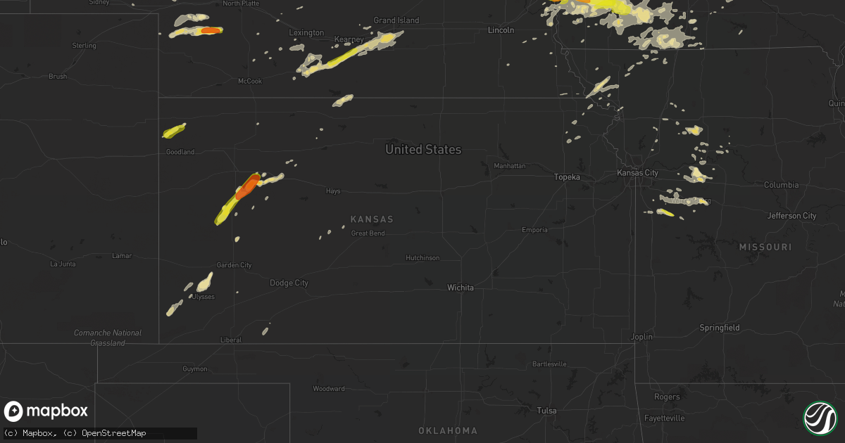
Hail Map in Kansas on August 31, 2018
Get this storm
August 31 map
$229
one time, instant access
Download today. No call, no setup
Keep the $229
Bought the map and want the full workflow? Apply the entire $229 to a subscription within 7 days. None of it is wasted.
Every map, not just this one
This buys you this map. Subscription and you get every map we run, in the markets you choose from a few cities to whole states to nationwide. Plus real-time alerts the moment a storm fires.
Contact data
Name, contact info, occupancy, even credit band for addresses in the footprint. You go from where it hit to who to call.
Become the source they trust
Unlimited branding weather history reports on demand. You already have the documented answer ready for the property owner, and you are the one who showed up with it.
Property data and RoofTrace estimates
Pull up any address you have got, its value and the exact code rules for that jurisdiction, straight from One Click Code. Then RoofTrace estimates the squares, pitch, and roof value, priced the way you price.
Storm reports in Kansas
Kansas
| Date | Description |
|---|---|
| 08/31/20185:10 AM CDT | At 1009 PM CDT, a severe thunderstorm was located near Quinter, moving northeast at 25 mph. HAZARD...60 mph wind gusts and quarter size hail. SOURCE...Radar indicated. IMPACT...Hail damage to vehicles is expected. Expect wind damage to roofs, siding, and trees. Locations impacted include... Quinter, Park and Saint Peter. This includes Interstate 70 in Kansas between mile markers 97 and113. |
| 08/31/20184:39 AM CDT | At 939 PM CDT, a severe thunderstorm was located 7 miles west of Gove, moving northeast at 30 mph. HAZARD...Two inch hail and 70 mph wind gusts. SOURCE...Radar indicated. IMPACT...People and animals outdoors will be injured. Expect hail damage to roofs, siding, windows, and vehicles. Expect considerable tree damage. Wind damage is also likely to mobile homes, roofs, and outbuildings. Locations impacted include... Quinter, Grainfield, Grinnell, Gove, Park, The Monument Rocks and Angelus.This includes Interstate 70 in Kansas between mile markers 80 and109. |
| 08/31/20184:17 AM CDT | At 917 PM CDT, a severe thunderstorm was located 10 miles northeast of Scott State Lake, moving northeast at 25 mph. HAZARD...Golf ball size hail and 70 mph wind gusts. SOURCE...Radar indicated. IMPACT...People and animals outdoors will be injured. Expect hail damage to roofs, siding, windows, and vehicles. Expect considerable tree damage. Wind damage is also likely to mobile homes, roofs, and outbuildings. Locations impacted include... Oakley, Grinnell, Gove and The Monument Rocks. This includes Interstate 70 in Kansas between mile markers 76 and 90. |
| 08/31/20183:48 AM CDT | At 848 PM CDT, a severe thunderstorm was located 7 miles southwest of Scott State Lake, moving northeast at 35 mph. HAZARD...60 mph wind gusts and quarter size hail. SOURCE...Radar indicated. IMPACT...Hail damage to vehicles is expected. Expect wind damage to roofs, siding, and trees. Locations impacted include... Scott State Lake. |
| 08/31/20183:46 AM CDT | At 846 PM CDT, a severe thunderstorm was located 7 miles northeast of Modoc, moving northeast at 35 mph. HAZARD...70 mph wind gusts and ping pong ball size hail. SOURCE...Radar indicated. IMPACT...People and animals outdoors will be injured. Expect hail damage to roofs, siding, windows, and vehicles. Expect considerable tree damage. Wind damage is also likely to mobile homes, roofs, and outbuildings. Locations impacted include... The Monument Rocks. |
| 08/31/20183:11 AM CDT | At 810 PM MDT/910 PM CDT/, a severe thunderstorm was located 9 miles southwest of Bird City, or 10 miles southeast of St. Francis, moving northeast at 35 mph. HAZARD...70 mph wind gusts and half dollar size hail. SOURCE...Radar indicated. IMPACT...Hail damage to vehicles is expected. Expect considerable tree damage. Wind damage is also likely to mobile homes, roofs, and outbuildings. Locations impacted include... Bird City and McDonald. |
| 08/31/20182:47 AM CDT | At 747 PM MDT/847 PM CDT/, a severe thunderstorm was located 13 miles south of St. Francis, moving northeast at 25 mph. HAZARD...70 mph wind gusts and quarter size hail. SOURCE...Radar indicated. IMPACT...Hail damage to vehicles is expected. Expect considerable tree damage. Wind damage is also likely to mobile homes, roofs, and outbuildings. Locations impacted include... Bird City and Wheeler. |
| 08/30/20189:53 PM CDT | A local report indicates 70 MPH wind near GRAINFIELD |
| 08/30/20189:45 PM CDT | Report via the public of quarter to golf ball sized hail 3 w of gove with a severe-warned and tornado-warned storm friday night. Time estimated based on radar. |
| 08/30/20189:45 PM CDT | Report via the public of thunderstorm wind damage. Damage includes whole large trees uprooted... Large tree branches down... A broken south-facing window... A metal roo |
| 08/30/20189:37 PM CDT | A local report indicates 1.75 inch wind near 3 W GOVE |
| 08/30/20189:13 PM CDT | At 213 AM CDT, a severe thunderstorm was located over Forest City, or 8 miles north of Highland, moving northeast at 15 mph. HAZARD...Half dollar size hail. SOURCE...Radar indicated. IMPACT...Damage to vehicles is expected. Locations impacted include... Oregon and Forest City. This includes Interstate 29 between mile markers 73 and 77. |
| 08/30/20188:57 PM CDT | A local report indicates 1.00 inch wind near 3 WSW SCOTT STATE LAKE |
| 08/30/20188:49 PM CDT | A local report indicates 60 MPH wind near 7 SW SCOTT STATE LAKE |
| 08/30/20188:36 PM CDT | At 136 AM CDT, a severe thunderstorm was located 5 miles southwest of Muscotah, moving northeast at 15 mph. HAZARD...60 mph wind gusts and half dollar size hail. SOURCE...Radar indicated. IMPACT...Hail damage to vehicles is expected. Expect wind damage to roofs, siding, and trees. This severe thunderstorm will remain over mainly rural areas of northeastern Jackson County. |
All States Impacted by Hail Map on August 31, 2018
Cities Impacted by Hail Map on August 31, 2018
- Kearney, NE
- Anita, IA
- Adair, IA
- Exira, IA
- Glenwood, IA
- Pacific Junction, IA
- Sutherland, NE
- Hershey, NE
- Holden, MO
- Harrisonville, MO
- Creighton, MO
- Garden City, MO
- Pelkie, MI
- Lanse, MI
- Wallace, NE
- Elsie, NE
- Madrid, NE
- Owatonna, MN
- Cloquet, MN
- Fairmount, ND
- Emerson, IA
- Imogene, IA
- Randolph, IA
- Malvern, IA
- Hastings, IA
- Ferrum, VA
- Council Bluffs, IA
- Grant, NE
- Venango, NE
- Clifton, AZ
- Halsey, NE
- Mount Ayr, IA
- Brock, NE
- Talmage, NE
- Martinsville, MO
- Braymer, MO
- Ludlow, MO
- Dawn, MO
- New Sharon, IA
- What Cheer, IA
- Rose Hill, IA
- Oskaloosa, IA
- Mayodan, NC
- Holton, KS
- Kellerton, IA
- Lamoni, IA
- Underwood, MN
- Arnold, NE
- Fairfax, MO
- Centerview, MO
- Odessa, MO
- Montezuma, IA
- Searsboro, IA
- Hartwick, IA
- Brooklyn, IA
- Malcom, IA
- Grinnell, IA
- Wadena, MN
- Deer Creek, MN
- Virginia Beach, VA
- Chesapeake, VA
- Concordia, MO
- Park, KS
- Axtell, NE
- Edison, NE
- Oxford, NE
- Minden, NE
- Atlanta, NE
- Bertrand, NE
- Funk, NE
- Holdrege, NE
- Heartwell, NE
- Kenesaw, NE
- Wood River, NE
- Henning, MN
- Clitherall, MN
- Vining, MN
- Fergus Falls, MN
- Battle Lake, MN
- Lucama, NC
- Wilson, NC
- Ellsworth, WI
- Fort Mill, SC
- Rock Hill, SC
- Papillion, NE
- Rush Center, KS
- Fisher, MN
- La Pointe, WI
- Gladbrook, IA
- Canyon, MN
- Alborn, MN
- Saginaw, MN
- Brookston, MN
- Peru, IA
- Campbellsburg, IN
- Crosslake, MN
- Pequot Lakes, MN
- Pine River, MN
- Nisswa, MN
- Otoe, NE
- Nebraska City, NE
- Lawson, MO
- Lathrop, MO
- Holt, MO
- Badger, MN
- Roseau, MN
- Bayfield, WI
- Cornucopia, WI
- San Carlos, AZ
- Brewster, NE
- Purdum, NE
- Higginsville, MO
- Corder, MO
- Gothenburg, NE
- Dickens, NE
- Cumberland, IA
- Griswold, IA
- Masonville, IA
- Coggon, IA
- Urbana, IA
- Rowley, IA
- Vinton, IA
- Winthrop, IA
- Center Point, IA
- Walker, IA
- Bloomfield, KY
- Knoxville, IA
- Corning, IA
- Villisca, IA
- Oshkosh, NE
- Chappell, NE
- Big Springs, NE
- Lewellen, NE
- White Pine, MI
- Wakefield, MI
- Bessemer, MI
- Ontonagon, MI
- Montour, IA
- Tama, IA
- Aurora, NC
- Scott City, KS
- Wiota, IA
- Edgewood, IA
- Toledo, IA
- Marne, IA
- Atlantic, IA
- Underwood, IA
- Crescent, IA
- Hager City, WI
- Marienthal, KS
- Cowgill, MO
- Floodwood, MN
- Wright, MN
- Sigourney, IA
- Stapleton, NE
- Arapahoe, NE
- Macedonia, IA
- Carbon, IA
- Lenox, IA
- Cromwell, IA
- Treynor, IA
- Oakland, IA
- Walnut, IA
- Grant, IA
- Massena, IA
- Bellevue, NE
- Red Oak, IA
- Stanton, IA
- Elliott, IA
- Silver City, IA
- Lewis, IA
- Henderson, IA
- Carson, IA
- Omaha, NE
- Diagonal, IA
- Prescott, IA
- Nodaway, IA
- Creston, IA
- Esko, MN
- Hancock, MI
- Aitkin, MN
- Tintah, MN
- Inverness, FL
- Chassell, MI
- Lake Linden, MI
- Harvey, IA
- Pella, IA
- Collyer, KS
- Quinter, KS
- Cromwell, MN
- Agra, KS
- Tryon, NE
- Stockville, NE
- Stuart, VA
- Woolwine, VA
- Hankinson, ND
- Crosby, MN
- Merrifield, MN
- Gonvick, MN
- Madison, NC
- Greenwood, DE
- Houston, DE
- Lincoln, DE
- Milford, DE
- Grinnell, KS
- Oakley, KS
- Gove, KS
- Leoti, KS
- Watersmeet, MI
- Eldridge, IA
- Bettendorf, IA
- Princeton, IA
- Davenport, IA
- Le Claire, IA
- Anselmo, NE
- Merna, NE
- Traer, IA
- Brayton, IA
- Lakin, KS
- Ulysses, KS
- Tracy, IA
- Meade, KS
- Afton, IA
- Warrensburg, MO
- West Point, NE
- Dodge, NE
- Weldon, IA
- Osceola, IA
- Eckerman, MI
- Essex, IA
- Meadowlands, MN
- Ramah, NM
- Carrollton, MO
- Norborne, MO
- Max Meadows, VA
- Campbell, MN
- Wahpeton, ND
- Hancock, IA
- Walsh, CO
- Bogard, MO
- Grants, NM
- Duluth, MN
- Palmyra, NE
- Unadilla, NE
- Pleasant Hill, MO
- Adams, NE
- Reinbeck, IA
- Gallatin, MO
- International Falls, MN
- Waterloo, IA
- Hudson, IA
- La Porte City, IA
- Alma, MO
- Blackburn, MO
- Britton, SD
- University Park, IA
- Gibson, IA
- Beacon, IA
- Fremont, IA
- Barnes City, IA
- Deep River, IA
- Delta, IA
- Keswick, IA
- Saint Francis, KS
- Goodland, KS
- Bird City, KS
- Kanorado, KS
- Johnson, KS
- East Grand Forks, MN
- Thompson, ND
- Paxton, NE
- Genoa, NE
- McClelland, IA
- Victor, IA
- Sebeka, MN
- Decatur, IA
- Freeman, MO
- New Effington, SD
- Sully, IA
- Isanti, MN
- Lemoyne, NE
- Brule, NE
- Ogallala, NE
- Keystone, NE
- Doniphan, NE
- Hastings, NE
- Juniata, NE
- Loomis, NE
- Giltner, NE
- Big Clifty, KY
- Leitchfield, KY
- Garfield, KY
- Eastview, KY
- Globe, AZ
- Chariton, IA
- Elizabethtown, NC
- Garland, NC
- Monroe, IA
- Reasnor, IA
- Verndale, MN
- Lutsen, MN
- Boone, IA
- Ogden, IA
- Moyock, NC
- Lynnville, IA
- Columbia, IA
- Mcgregor, MN
- Deerwood, MN
- Tamarack, MN
- Palisade, MN
- Melcher Dallas, IA
- Killduff, IA
- Newton, IA
- Bussey, IA
- Chelsea, IA
- Guernsey, IA
- Otley, IA
- Lovilia, IA
- Swan, IA
- Leighton, IA
- Hamilton, IA
- Staples, MN
- Motley, MN
- Creswell, NC
- Roper, NC
- Salem, NE
- Crystal Falls, MI
- Amasa, MI
- Hazel Green, WI
- Cuba City, WI
- Platteville, WI
- Salem, IN
- Springfield, CO
- Columbia, NC
- Pima, AZ
- Fontanelle, IA
- North Platte, NE
- Crookston, MN
- Mule Creek, NM
- Union, NE
- Murray, NE
- Emily, MN
- Clemons, IA
- Hayfield, MN
- Kasson, MN
- Dodge Center, MN
- Felton, DE
- Harrington, DE
- Kettle River, MN
- Sawyer, MN
- Winterset, IA
- Dalton, MN
- Goodridge, MN
- Columbus, NE
- Grant City, MO
- Parnell, MO
- Ravenwood, MO
- Plattsmouth, NE
- Curtis, NE
- Garden Grove, IA
- Knob Noster, MO
- Whiteman Air Force Base, MO
- Cameron, MO
- Turney, MO
- Rocky Mount, VA
- Clarkton, NC
- Shullsburg, WI
- Benton, WI
- Burdett, KS
- Pollocksville, NC
- Neola, IA
- East Dubuque, IL
- Muscotah, KS
- Effingham, KS
- Ironton, MN
- Port Wing, WI
- Big Lake, MN
- Becker, MN
- Farley, IA
- Dyersville, IA
- Iron River, MI
- Netawaka, KS
- Whiting, KS
- De Witt, IA
- Grand Mound, IA
- Kidder, MO
- Saint Cloud, MN
- Crystal River, FL
- Homosassa, FL
- Herbster, WI
- Geneva, MN
- Hartland, MN
- Ellendale, MN
- Clarks Grove, MN
- Hollandale, MN
- Kellogg, IA
- Gilman, IA
- Borden, IN
- Pickrell, NE
- Greene, IA
- Charles City, IA
- Manchester, IA
- Dundee, IA
- Clear Lake, MN
- Saint Joseph, MO
- Savannah, MO
- Graham, MO
- Skidmore, MO
- Craig, MO
- Maitland, MO
- Mound City, MO
- Forest City, MO
- Shelton, NE
- Gibbon, NE
- New Richland, MN
- Sparks, GA
- Adel, GA
- Oconto, NE
- Rogers, NE
- Schuyler, NE
- Howells, NE
- Mayview, MO
- Sweet Springs, MO
- Lexington, MO
- Davis City, IA
- Macksburg, IA
- Orient, IA
- Thayer, IA
- Murray, IA
- Mendon, MO
- Two Buttes, CO
- Grainfield, KS
- Calamus, IA
- Horton, KS
- Hiawatha, KS
- New Vienna, IA
- Worthington, IA
- Waverly, MO
- New York Mills, MN
- Ottertail, MN
- Worth, MO
- Sheridan, MO
- Lorimor, IA
- Lineville, IA
- Leon, IA
- Sublette, KS
- Phillipsburg, KS
- Kensington, KS
- Bloomington, NE
- Naponee, NE
- Mohawk, MI
- Redding, IA
- Blockton, IA
- Blooming Prairie, MN
- Claremont, MN
- Wytheville, VA
- Cripple Creek, VA
- Benson, NC
- Thief River Falls, MN
- Elkhart, KS
- Clearwater, MN
- La Monte, MO
- Washburn, WI
- Shelby, IA
- Falls City, NE
- Monticello, MN
- Macclesfield, NC
- Wellington, MO
- Elwood, NE
- Eustis, NE
- Dry Ridge, KY
- Foley, MN
- Bedford, IA
- Dunning, NE
- Nekoma, KS
- Maple Lake, MN
- Annandale, MN
- Wells, MN
- Roosevelt, MN
- Cotton, MN
- Zimmerman, MN
- Princeton, MN
- Miami, MO
- Oregon, MO
- Holland, IA
- Grundy Center, IA
- Mystic, IA
- Hamilton, MO
- Stantonsburg, NC
- Leeton, MO
- Garwin, IA
- Red Lake Falls, MN
- Cascade, IA
- Rulo, NE
- Barnard, MO
- Bolckow, MO
- White Cloud, KS
- Healy, KS
- Bardstown, KY
- Sunbury, NC
- Hobbsville, NC
- Guttenberg, IA
- Van Horne, IA
- Shellsburg, IA
- Garrison, IA
- Syracuse, NE
- Lynch Station, VA
- Belle Plaine, IA
- Keystone, IA
- Kingsville, MO
- Jacobson, MN
- Galena, IL
- New Castle, VA
- Garber, IA
- Brunswick, MO
- Frederica, DE
- Ellendale, DE
- Dubuque, IA
- Dike, IA
- Rosholt, SD
- Nashua, MN
- Lidgerwood, ND
- Madrid, IA
- Logan, KS
- Albemarle, NC
- Stockton, KS
- De Witt, MO
- Marshalltown, IA
- Bluffton, MN
- Menahga, MN
- Two Harbors, MN
- Emerado, ND
- Robinson, KS
- Highland, KS
- Eyota, MN
- Clarinda, IA
- Gravity, IA
- Edward, NC
- Lancaster, WI
- Cassville, WI
- Bloomington, WI
- Pekin, IN
- Moorefield, NE
- Saint Hilaire, MN
- Plummer, MN
- Morland, KS
- Holy Cross, IA
- Fillmore, MO
- Vallonia, IN
- Whiteriver, AZ
- Spring Valley, WI
- Auburn, NE
- La Vista, NE
- Mineola, IA
- Denver, MO
- Camanche, IA
- Malta Bend, MO
- Tingley, IA
- Shannon City, IA
- Bridgewater, IA
- New Market, IA
- Nehawka, NE
- Louisville, NE
- Offutt Afb, NE
- Ellston, IA
- Warwick, GA
- Beemer, NE
- Cambridge, MN
- Durango, IA
- Sherrill, IA
- Camden, NC
- Cecilia, KY
- Elk Creek, VA
- Dover, MO
- Long Grove, IA
- Belvidere, NC
- Grand River, IA
- Clearfield, IA
- Van Wert, IA
- Benton, IA
- Strasburg, MO
- Hill City, KS
- Penokee, KS
- Farragut, IA
- Greenfield, IA
- River Falls, WI
- Oberlin, KS
- Union Hall, VA
- Kimball, MN
- Kearney, MO
- Maiden, NC
- Newton, NC
- Hopkinton, IA
- Delhi, IA
- Epworth, IA
- Earlville, IA
- Elm Creek, NE
- Blairstown, MO
- Bates City, MO
- Lone Jack, MO
- Nashua, IA
- Avoca, IA
- Backus, MN
- Tomahawk, WI
- Rhinelander, WI
- Boulder Junction, WI
- Conception Junction, MO
- Beldenville, WI
- Sauk Rapids, MN
- Salol, MN
- Winona, KS


